Scarlet Pimpernel
-
Posts
7,815 -
Joined
-
Last visited
Content Type
Profiles
Blogs
Forums
American Weather
Media Demo
Store
Gallery
Everything posted by Scarlet Pimpernel
-
 I hear King John remembered that storm well!!
 -
Well, for the Cleveland Browns it's not superstition over the past couple of decades. They just suck and don't play well no matter what the situation, the opponent, or time of year!!!
-
I think the "weekend rule" stuff is over-stated, and/or stated with some jest. If one considers Friday as essentially nearly the weekend and considers that many events spill over into another day (e.g., starts later Friday, goes into or through Saturday), you're talking nearly half the week right there. So yeah, decent chance a storm will occur then. Add in Monday holidays in the winter (MLK Day, Pres Day) and that's even more "weekend" relatively speaking. Plus, perception bias in part, one tends to perhaps recall events that occur on a weekend more.
-
Agree. I can recall several advisory to warning-level snows between late February and mid-March, it's really not all that rare of a thing relatively speaking. I know there are those who tend to thumb their nose at later season snow events but we've had a decent number. And in not the greatest setups, too.
-
You do realize that the sleet bomb in the teens we had a couple of weeks ago was due to the mid-levels only. Nothing to do with the surface. And that was with a low cutting into the Ohio valley or there about. Point is, yeah, we were "saved" by very cold surface air in place while the surface and 850 low went way to our west but that was particular to that event. That doesn't mean such a thing would necessarily happen in another scenario where it's cold enough for snow but we get a better low track, say if that happens later this month or in March. You still don't need the coldest of the cold to get a good snow event here, even in the DC-Balt corridor.
-
Well, I wouldn't take what some deterministic model says at face value going farther out in time. I mean heck...if anyone saw the 12Z GFS earlier, it had cold coming back in the last part of its run and even had a decent snow event around the 24th. Not that it matters really that far out. So whatever.
-
LOL! Really? OK, yeah I definitely can agree we're done with Arctic air the rest of this winter. I mean, that's just climo and it's rare to get that level of cold as we get farther into this month and into March. So that's kind of a meaningless statement. But we don't need brutal cold to still get a solid wintry event or two between now and March.
-
Well, getting into the time of year when we typically don't "lock in" on any cold/warm setup so I guess that's not a surprise. I still think we don't get shut out the remainder of the season, and perhaps not even the rest of this month. A decent moderate event, maybe on the order of a SECS-MECS, would still have to be on the table I'd like to believe, between now and early-mid March. And perhaps a second event of some sort too if lucky.
-
2-m temps look horrid at 120, actually.
-
I haven't really paid much attention to the somewhat longer range in awhile. But is the previously thought more favorable NA later this month and early March now looking less likely? I recall there was some discussion awhile back about a PV split, and being on our side of the hemisphere, with a good shot at a return to more blocking around that time period. Not sure of the details though. It doesn't seem like the Pac side is going to do much to become better.
-
Appropriate for a "gray hat" then, I suppose?! Yeah, there's unfortunately a lot of localized IMBY complaining stuff in here, but I suspect that's in any other regional forum too. We've got our share of shit posters for sure, but also many, many excellent and knowledgeable ones. And realistically (for better or worse), a large majority of people in this sub-forum are in the DMV-Baltimore corridor (myself included). Just how it is. I guess I try not to let the weenie trollish and whiney comments drive me away from the otherwise good analysis and discussion from the others. Even if I personally am ticked off or disappointed at a result or how things are looking, I do my best to not let that spill over into this place with a lot of crap posting and whining.
-
True! It's still "civilized" at that time of year if you're warmer than normal! I still remember Dec. 2015, we had like a +9 departure for the month, ridiculous warmth (though it didn't feel overly uncomfortable at that time of year)...and I was thinking thank God we didn't get a +9 in July!!!
-
Well, I can do without 80s in March (though won't be the least bit surprised if we hit that at some point then)! We go well above 80 (or 90!) plenty of times each year already! But I'm with you, would be nice to score at least one really good warning-level event this season. Personally, I'd also like to see a modest March snow as well. And I'd like to see February into the first part of March remain generally BN. Agree as well! I know several in here are bummed that we got a ton of sleet from our one major event (rather than all snow) and feel it's all been a waste somehow. But I've liked the amazingly consistent cold and snow cover that literally has not diminished in 2 full weeks now due to that cold (and the layer of solid ice on top). I can literally walk on top of the ice layer and it's as if I'm walking on regular pavement (though more slippery, of course!), without sinking into it. It's actually rather easy to walk on.
-
The pendulum continues!

-
Just from my cursory look at both, it looks more Miller A-like to me. Primary low forms in the southeast and runs along the coast. Your typical Miller B would run a primary into TN/KY, and then a secondary forms off OBX or there about that takes over (in our more ideal situations for snow here from Miller Bs).
-
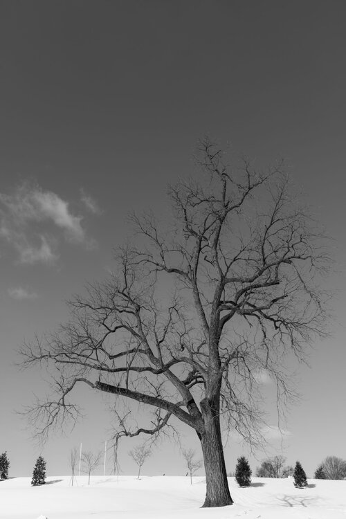
Yeah...and that tree just stands out by itself too. I will say, it was not the easiest to get a shot of. I had to work hard the first time I tried to avoid getting the brick wall along the side, the road, power lines, distant buildings farther up the Pike, and the driveway into the school in the shot. And still capture the entire tree (wide angle lens definitely needed!). I just wanted that tree with the background smaller trees and a bit of the grass in the foreground. Once I found a spot, it was easier to do the next times I went to get a photo. I'll offer this advice, if I may (such as it is!)...there's a telephone pole across from the tree (other side of the driveway entrance). I've found that standing propped up against that enabled me to avoid the other distracting elements I mentioned above.
-
Dafuq just happened in here?!?!
-
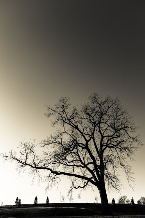
Many thanks! I live not that far from there so I've passed that school along Rockville Pike and have seen that tree many times. Always wanted to get some shots of it over the years...and finally a couple of years ago I made a point to do so. Have gotten a few photos of it since then, mainly in winter (the sparseness of the branches and how it stands out are more stunning, I think, with no leaves). Interesting side-note about that: I think sometime a year or so ago that one large branch at the bottom got cut off due to a bad storm. It actually used to extend farther out to the left side. Here's what I got (if I may) from almost exactly 3 years ago (Feb. 2023)...I actually like this shot that I took of the tree the most, using a creamy sort of black/white. It was taken later in the day (plus no snow on the ground then, grrr!), and it has that larger branch extending to the left. I like how it just stands out more, like a silhouette.
-
I believe that is an official index, like the NAO/AO/PNA/WPO/MJO!!
-
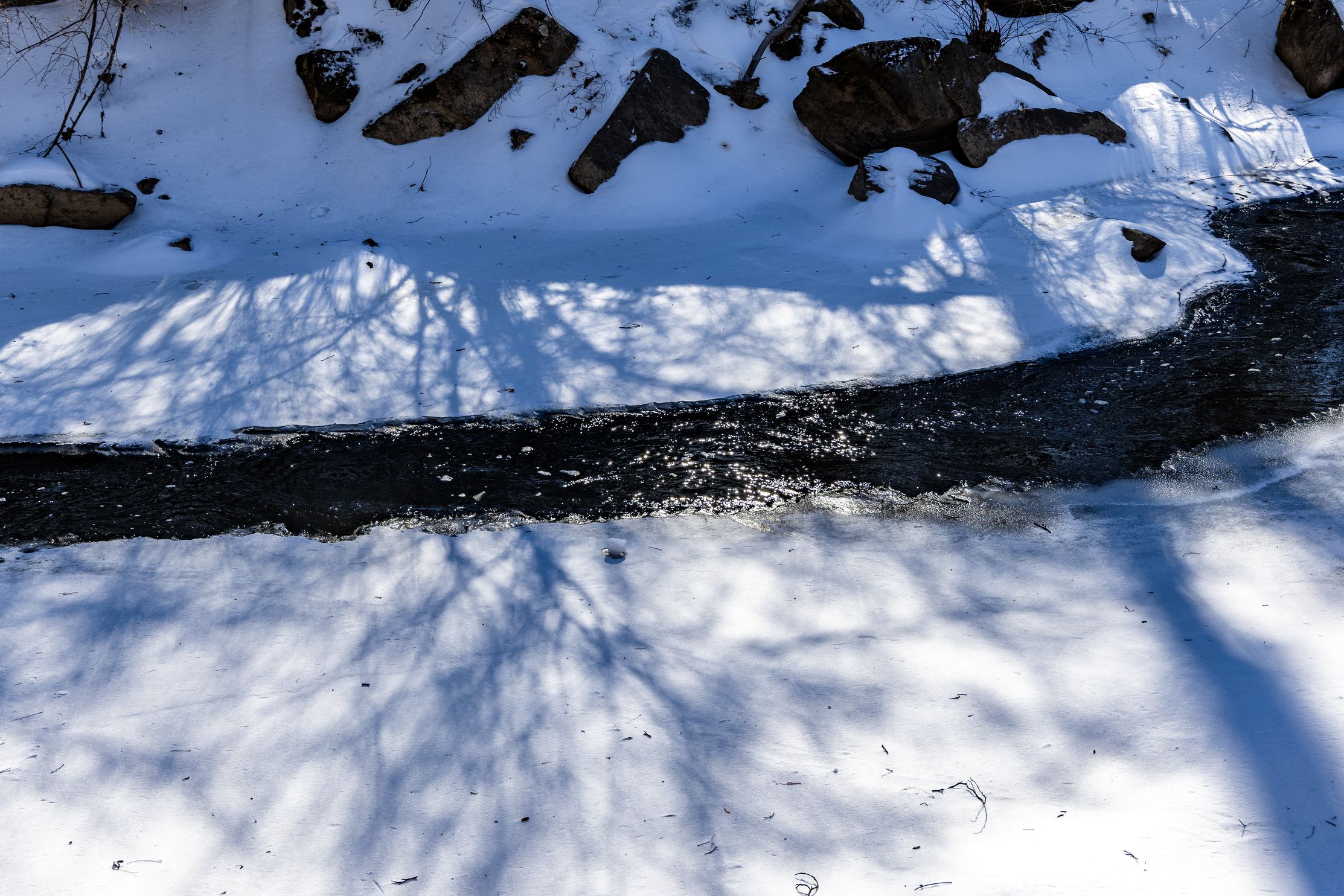
On a lighter note in here...took these shots yesterday. Yes, I went out in those conditions to do a little photography!! First one is of a nearly completely frozen Rock Creek here in suburban MD (Rock Creek Trail, near Bethesda/Silver Spring). Second one is a tree at the entrance of the Georgetown Prep school, I have always liked that tree, it's very stately-looking (black and white image)...

-
Yeah, I was going to post this the other day but I appreciate this thread. General discussion on what the overall pattern looks like, and how/if some threat could actually materialize. Without the whining, etc., with every model run. I take it that if an actual event threat materializes, that will be discussed more in the regular medium range (and potentially eventual storm specific thread). OK, on topic: It does appear that next weekend's possibility is looking pretty slim right now. I know most guidance has been advertising a general warmup sometime just after next weekend, but it's unclear (to me) how entrenched that gets. I've only followed the guidance (500-mb mainly) in a cursory way, trying to see how things evolve as we get into the last week or so of this month. It seems to me that the warmup doesn't look "extreme" and we kind of end up after that in a sort of changeable look with potential favorable situations for some decent snow chances. I am still hopeful from various things I've seen in here (various indices, extended Euro guidance, etc.) that we're not done yet. I still believe that we don't escape February with zero snow; not a HECS system, but I think a SECS to a MECS level event surely must be on the table. Similarly for the first part of March.
-
Agree. Fact is, potential is there not just for next weekend but some period beyond that as well. It doesn't appear to be wall to wall shit the blinds. (Oh no, I posted medium range discussion in the Banter thread rather than banter in the Medium Range thread!!! LOL!! )
-
FYP a little!! I swear, the freak out "OMG, I lost 8" snow since the last run, we suck, it's done!"
-