Scarlet Pimpernel
-
Posts
7,812 -
Joined
-
Last visited
Content Type
Profiles
Blogs
Forums
American Weather
Media Demo
Store
Gallery
Everything posted by Scarlet Pimpernel
-

Late February/Early March 2026 Mid-Long Range
Scarlet Pimpernel replied to WxUSAF's topic in Mid Atlantic
Well, you know in Gilbert & Sullivan's "Mikado", the "piano organist" is on Ko-Ko's list for potential victims to be beheaded!! (BTW, "guy" in these lyrics as I understand it, refers to someone dressing like Guy Fawkes, for Guy Fawks Day. Silly Brits!!!) There's the banjo serenader, and the others of his race And the piano-organist — I've got him on the list! And the people who eat peppermint and puff it in your face They never would be missed — they never would be missed! Then the idiot who praises, with enthusiastic tone All centuries but this, and every country but his own; And the lady from the provinces, who dresses like a guy And who "doesn't think she dances, but would rather like to try"; And that singular anomaly, the lady novelist — I don't think she'd be missed — I'm sure she'd not be missed! -
FYP!!!
-
Late February/Early March 2026 Mid-Long Range
Scarlet Pimpernel replied to WxUSAF's topic in Mid Atlantic
You mean, it IS (or was) showing nothing at 12Z? -
Late February/Early March 2026 Mid-Long Range
Scarlet Pimpernel replied to WxUSAF's topic in Mid Atlantic
Can't exactly recall what 12Z looked like, but the overall "distribution" looks a bit more "even" so to speak. -
Late February/Early March 2026 Mid-Long Range
Scarlet Pimpernel replied to WxUSAF's topic in Mid Atlantic
The comment you replied to is kind of ridiculous on its face, with the "Climo absolutely says no to this one." Seriously? Yeah, "climatologically" our odds decrease as we now head later into the season and March. But "absolutely no" is, to put it not so politely, a silly thing to say. I guess all those later season and March snows we've gotten over the years never occurred. In reality, we're generally realistically "in the game" for at least something up to perhaps about mid-March. Could we end up with little or nothing or even rain from this potential event? And nothing the rest of the season? Yeah, sure...of course! But I wouldn't say that's because "climo told us it's a no-go and it just followed that!" Each discrete event is its own entity with the given conditions as they exist; in other words, "climatology" is different from "weather." -
Late February/Early March 2026 Mid-Long Range
Scarlet Pimpernel replied to WxUSAF's topic in Mid Atlantic
Personally, if we can end up with a fun, decent event that can drop a few inches or so of snow, that would be a win as far as I'm concerned. Seems too many people are waaaaay too invested in some kind of upper end MECS to HECS event because some runs of the regular dynamic and the AI models showed that possibility lately...and then tear their hair out if they show anything less the next cycle, with assumptions about "trending" negatively and that's now guaranteed. I think most or all of us here are wary enough to not expect the high end solutions at this point this far out, as much as that would be nice. We don't need constant reminders about such things as "seasonal trend", "OMG, it's a Nina so we're screwed", "we never do well in Miller-B systems!", etc. Just freaking follow and track the event until such time that it's either nothing much, or we end up having something real here that's at least pretty decent. If you don't want to do that or can't deal with it, then at least keep the doom posting to yourself please. -
Yup. The f'ing doom posting is ridiculous. "Oh no, it's not a HECS, that means it's guaranteed to be nothing!!! And it's trending toward the not-so-great 12Z Euro run!! OMG!!!" Jesus. H. Christ!
-
Yeah...I swear the doom-posting with every SLIGHT change in the models every 6 hours if it doesn't show wall-to-wall HECS level snows in general is a pain in the ass and a huge one at that. Page after page of whining and saying we're toast, or "I told you that you all are just chasing a rainstorm but you wouldn't listen to my secret expertise!" You know what? We may be toast, but at this point who knows. But you know what else? Who cares. We track something interesting because we all are looking for snow, and we'll track it to the end or until such point that it looks like a loss. I'm not going to assume that "OMG it's trending badly, it's over!!!" because a couple of models seem to "back off" from 18" snow during some run. But it's no fun to sift through all the BS either. It would be nice to see the lower end of the goal posts converge on a few inches or so of snow for this upcoming potential, that would be a fun event...with an upper end of a serious MECS (or better!) possible. The whining and over-concern worry is bad enough with any event, but the troll-like posts are way over the top, up to and including actually disparaging professional mets and others in here who are very knowledgeable. That just crosses a big red line. So yeah, maybe not outright "banning" those that engage in that, but the old 5-posting would help. Maybe that would make those who are deliberately shit-stirring and trolling think twice...but if not, they at least wouldn't be posting more than 5 times within some time frame.
-
Late February/Early March 2026 Mid-Long Range
Scarlet Pimpernel replied to WxUSAF's topic in Mid Atlantic
Uhhh, weekend/week of the 23rd IS the last week of February! (ETA: See, we even get screwed for winter by the calendar, the shortest season in terms of number of days and includes the shortest month of the year!! ) -
Late February/Early March 2026 Mid-Long Range
Scarlet Pimpernel replied to WxUSAF's topic in Mid Atlantic
Thanks. Hard to tell how "heavy" the precip is in that image above, with those green shadings (and what they mean). On a related note, I believe the AI models typically are not the greatest for amounts, but are better for overall coverage. Something like that. -
Late February/Early March 2026 Mid-Long Range
Scarlet Pimpernel replied to WxUSAF's topic in Mid Atlantic
That due to not much precip, or due to temperatures that are too warm and bleah? -
Late February/Early March 2026 Mid-Long Range
Scarlet Pimpernel replied to WxUSAF's topic in Mid Atlantic
"It is easier for a camel to pass through the eye of a needle than it is for us to get a snowstorm!" But seriously, I still kinda have hope for that general period around the 24th. The 12Z GFS looked craptastic for much of its run but even still showed some potential near that time. Earlier runs showed similar hints too. -
Late February/Early March 2026 Mid-Long Range
Scarlet Pimpernel replied to WxUSAF's topic in Mid Atlantic
We need a helmet catch Hail Mary a'la the NY Giants in Super Bowl XLII!! -
You know it's bad when the medium range thread has several plots of the 300+ hour deterministic GFS showing warmth, and relative silence about that. If it were a major snowstorm being shown, everyone would be saying "looks great, but it's the GFS and at 300 hours, no way that happens!"
-
Problem from what I can see in the 00Z GFS around the 24th is that it has a low in southern Canada, which I would guess is kind of messing things up with the main system of interest that would affect us. Maybe not quite the same as a Lakes low, but I'd have to think it isn't ideal.
-
Favorite Atmospheric/Sky Phenomenon
Scarlet Pimpernel replied to SnowenOutThere's topic in Mid Atlantic
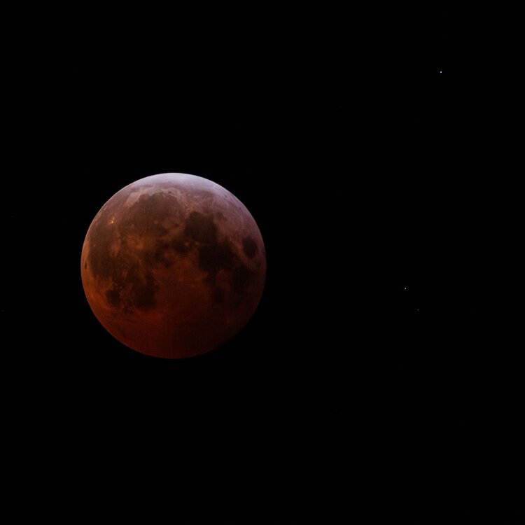
Oh and BTW, thanks @SnowenOutThere for starting this thread!! Really cool, and some amazing shots in here including yours. Photography is a serious hobby and big interest of mine, I'm curious what camera/lenses you use. The lunar eclipse is actually a bit tricky to get in a way...you need a long enough shutter because it's so much dimmer, and you also have to crank up the ISO a bit. But at least it's not fleeting so one has time to take several shots at various settings and hope a couple or so come out well! I ended up doing some noise reduction in post as well as boosting the red color a bit. Had to crop it too, though I did use a long telephoto for my shot. More recent cameras have gotten better about noise control at higher ISOs, until you get up to the really extreme values (which I have only used on very rare occasion). -
Favorite Atmospheric/Sky Phenomenon
Scarlet Pimpernel replied to SnowenOutThere's topic in Mid Atlantic
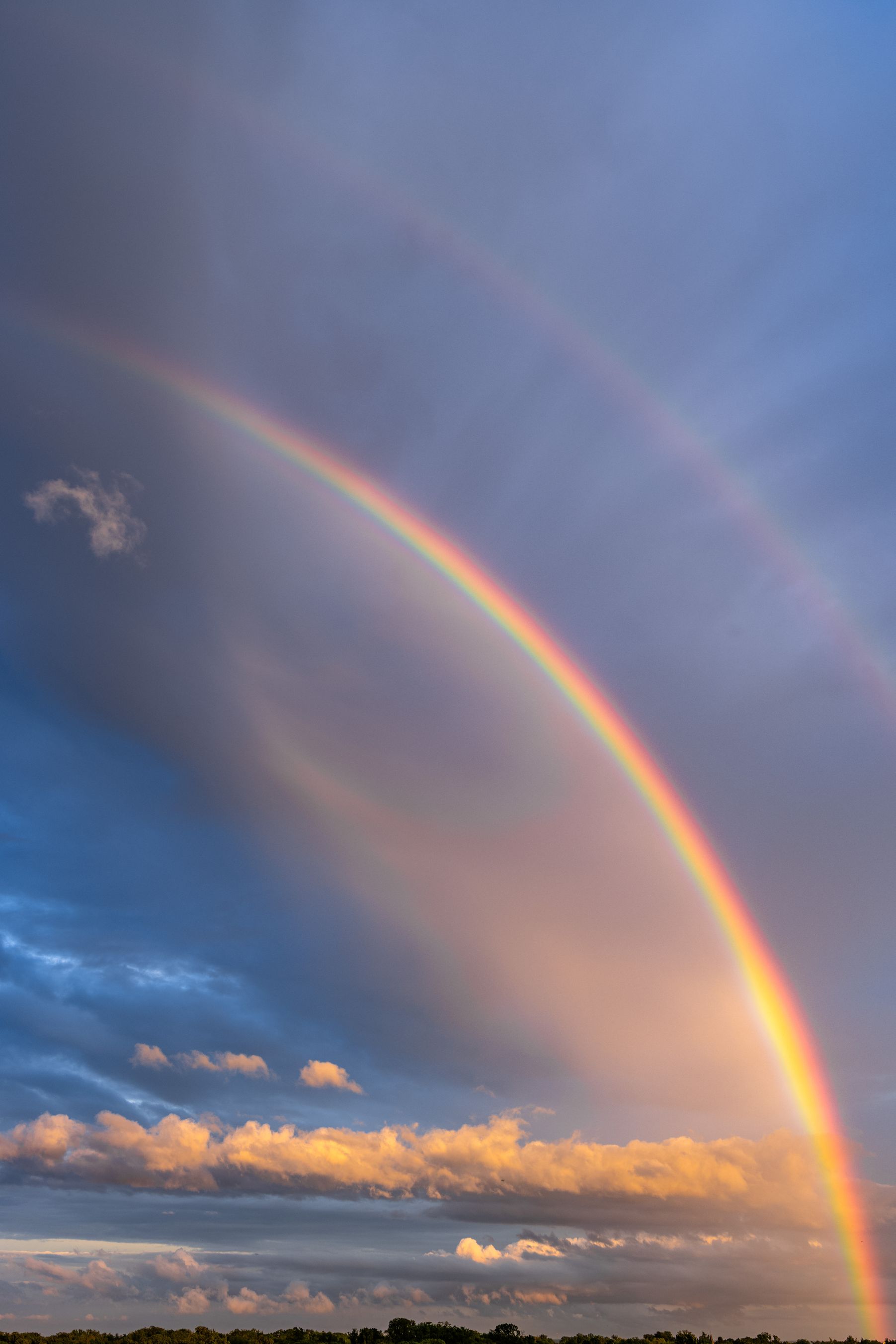
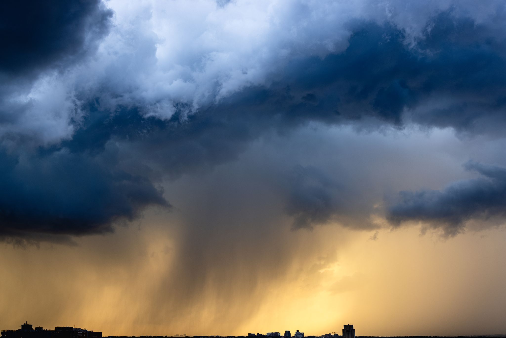
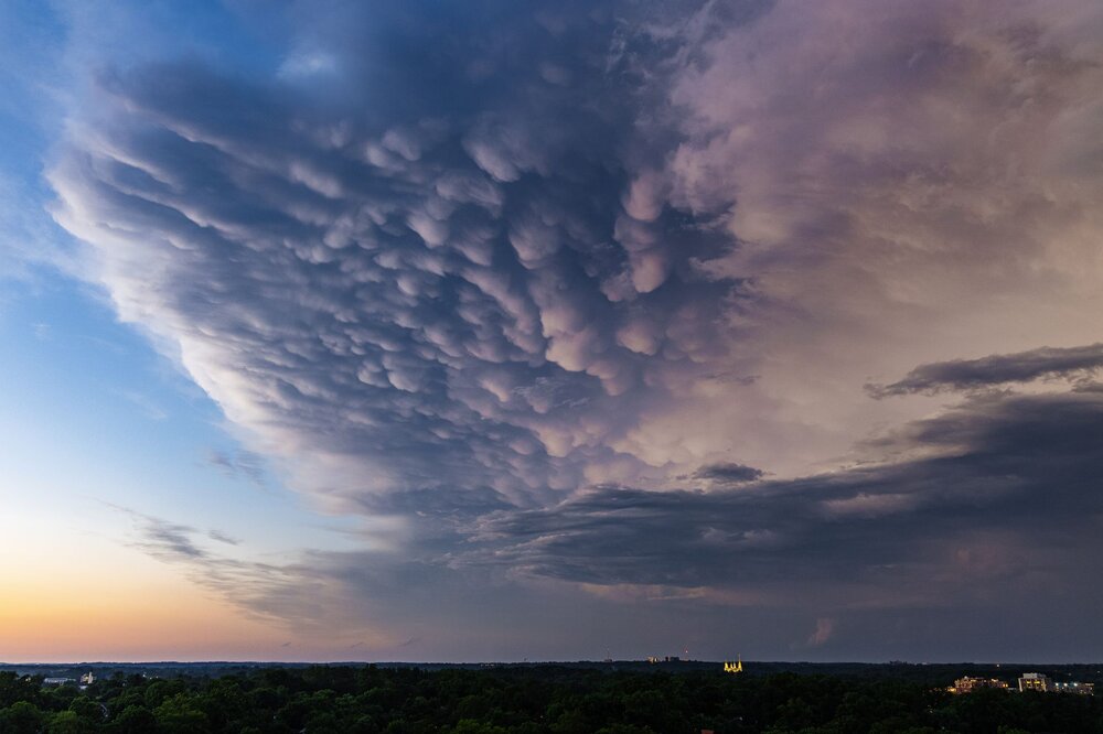
Here are some that I got. One is the lunar eclipse from March 2025...if you look closely, those are actually stars to the right in the photo. The normally bright full moon would have totally obscured those, but during a total lunar eclipse, it is very muted. The others include: a double rainbow, an incoming storm near sunset, blood-red clouds near sunset, and mammatus clouds at the edge of a storm (maybe from the same storm that @Bob Chill showed above??). I always like the sunset colors, the sky and any clouds change color constantly.


-
Not quite sure what to make of that. On the one hand, it looks like the NA is less favorable with lower heights up around Greenland, whereas the other day or so it looked better. On the other hand, the overall heights are not bad, relatively "flat" over much of the US (and no big southeast ridge). Plus, there appear to be lower heights on this side of the pole and a bit of a 50/50 trough. Seems like that could perhaps at least keep some chances for cold incursions from decent high pressures in Canada. ETA: While there were no specific threats that seemed evident in today's deterministic ops runs, some threats have appeared in the guidance on several occasions lately in this time period. For instance, yesterday's 18Z GFS had what looked like a couple or so decent shots. Those were gone today but as long as we can keep seeing those show up it would be nice, and hopefully have one or two really take shape as it gets closer.
-
Hopefully not a GFS modeling gig!!! But seriously, have a fun time up there!!
-
I posted a response in the main medium range thread, but even though this is an ops out there in time...this kind of threat has shown up in ops runs (not just the GFS) and even ensembles(?) in that time period, several times lately. So I don't think it's just fantasy land bullshit. Not saying for sure we'll get something, but it catches one's attention.
-
I know we can all laugh at an ops model at range...but a pretty good event has shown up in the ops (not just the GFS) several times now in that time frame. Not guaranteed obviously, but I don't think it's just fantasy either.
-
I hear King John remembered that storm well!!
-
Well, for the Cleveland Browns it's not superstition over the past couple of decades. They just suck and don't play well no matter what the situation, the opponent, or time of year!!!
-
I think the "weekend rule" stuff is over-stated, and/or stated with some jest. If one considers Friday as essentially nearly the weekend and considers that many events spill over into another day (e.g., starts later Friday, goes into or through Saturday), you're talking nearly half the week right there. So yeah, decent chance a storm will occur then. Add in Monday holidays in the winter (MLK Day, Pres Day) and that's even more "weekend" relatively speaking. Plus, perception bias in part, one tends to perhaps recall events that occur on a weekend more.