BlunderStorm
-
Posts
1,121 -
Joined
-
Last visited
Content Type
Profiles
Blogs
Forums
American Weather
Media Demo
Store
Gallery
Everything posted by BlunderStorm
-
Ahh, I believe I was under the storm during or after your convection timelapse. The weather yesterday was all over the place. It seemed not an hour or two would go by without sunshine and rainfall.
- 225 replies
-
- 1
-

-
- mountain snow
- thunderstorms
- (and 5 more)
-
 17/9/4 May: 1/0/0 June: 1/0/0 July: 2/1/0 August: 4/2/1 September: 5/4/2 October: 3/2/1 Nov-Dec: 1/0/0
 -
It went down to 28 on Monday and was 34 Tuesday morning. May 1st marks the final frost here. The 2017-18 seasonal snow total was 23.32"
- 225 replies
-
- 2
-
-
- mountain snow
- thunderstorms
- (and 5 more)
-
It reached a low of 28 here some snow remains from yesterday but is quickly disappearing. I don't mind cold temperatures but it would be good to see the trees green once again sooner rather than later.
-
A good dusting of snow has settled on the ground in the past 40 minutes. At times the snow fell pretty heavily and during the snowfall the temperatures dropped from 34 to 29 as of now. 1 or 2 more squalls and I may have something measurable. I might post a few pictures later but I have to compress them first. What a wild spring!
- 225 replies
-
- 4
-
-
- mountain snow
- thunderstorms
- (and 5 more)
-
37 now with "mix" showers coming through. The top of Big A mountain is white. (The mountain on my cover photo.)
- 225 replies
-
- 1
-
-
- mountain snow
- thunderstorms
- (and 5 more)
-
A few snow flakes are flying outside in Honaker at the moment. It has to end soon, today is most likely the last snow of the season although there is the small likelihood of snow on the 20th. Beyond that taking my own words with a grain of salt I think we are in the clear for winter weather til October barring nuclear winter, a catastrophic volcanic eruption, or some other major unforeseen event that would affect our weather. I was conflicted over whether or not a trace of snow counted if it was only falling with nothing sticking but after reading over the definition it in fact does seem to be. Fortunately whenever it did snow it did at the very least stick for a time for me to record it as a trace so my records remained legitimate up until the last event a week ago which I only listed as a trace after the fact.
-
The total rainfall for today was 2.22 inches. Currently the temperature is 45 and is dropping quickly.
-
Spring/Summer 2018 Mid to Long Term Discussion.
BlunderStorm replied to John1122's topic in Tennessee Valley
Ok, this has to be the last winter threat...right? It seems like a decent NW flow event at a glance. 80 and snow! This is my kind of week! -
It was just a little too warm to snow this morning currently it is 35 with a mix of rain and snow without any accumulation. Still it is nice to see flakes flying when its cold.
-
I would say at the most a dusting occurred here before melting off the ground but to see snowfall this late was really something and to top it off it may spit some more snow Monday morning.
- 225 replies
-
- 2
-
-
- mountain snow
- thunderstorms
- (and 5 more)
-
It would seem the snow redevelopment has expanded into Tennessee as of right now moderate snow is falling and sticking on the grass! Currently it is 32.
- 225 replies
-
- 4
-
-
- mountain snow
- thunderstorms
- (and 5 more)
-
Spring/Summer 2018 Mid to Long Term Discussion.
BlunderStorm replied to John1122's topic in Tennessee Valley
Oh I should have kept my mouth shut the weather models pulled the carpet out from under us big time. By the time this *possible* near non-event is over it may have very well teased 4 sub-forums in the process. It is April though so what are you going to do. If there is some light at the end of the tunnel (if you even want it to snow at this point) it's that I noticed some redevelopment on radar along the KY-VA line seemingly extending into Tennessee about where John is although I wouldn't get my hopes up. -
Spring/Summer 2018 Mid to Long Term Discussion.
BlunderStorm replied to John1122's topic in Tennessee Valley
Yep we just got NAM'd big time. You can really see the drastic drop between 18z and 0z. EDIT: On a 2nd note the RGEM and ICON up the snow totals a little.
- 279 replies
-
- 1
-

-
- tornado
- thunderstorm
- (and 5 more)
-
Sometimes the NAM makes me burst out laughing. Here we are ladies and gentleman snow for northern Louisiana in April!
-
Spring/Summer 2018 Mid to Long Term Discussion.
BlunderStorm replied to John1122's topic in Tennessee Valley
Support for snow in the Tennessee Valley has went up across the board tonight as of the 0z runs especially for me. The GFS, CMC, EURO, 3km NAM, RGEM, HRDPS, and ICON all seem to show more snow. My understanding is very limited but a common thing all the models seemingly agree on is a more robust back end to the system or at least that is what I could gather from my untrained eye. Perhaps you all could elaborate more? -
Honaker briefly tapped 80 today for the first time since fall. The winds are currently 12 mph from the south.
- 225 replies
-
- 1
-
-
- mountain snow
- thunderstorms
- (and 5 more)
-
Well it's said conversation encourages conversation. This morning I was surprised to be met with mild air 56 to be exact as I left home, it's a welcome change but on the flip side of the coin the euro doesn't want to let go of winter which I'm also fine with. I'll take anything over the 40s with rain.
- 225 replies
-
- 1
-
-
- mountain snow
- thunderstorms
- (and 5 more)
-
Gradually my snow totals for the season have risen to around average. I would determine the snow depth by measuring in the middle of the yard most of the time. If the snow depth remained the same for roughly hour I recorded it and if it started to snow again I would add to it until taking a measurement at midnight. Sure there wasn't a blockbuster winter storm this season for me but each event slowly added up with "Miraculous March" making up for "Fabulous February"! If I were to add all my snow for the season counting my recording of dustings as 0.1" and traces as 0.01 it would be 21.47" if it doesn't snow again. All in all with everything accounted for this season wasn't bad after all. US climate data has Lebanon at only 11" and Richlands at 17" which I struggle to believe for a second. I really don't know what the average annual snowfall is here though so I guesstimate it's somewhere between 20" to 28".
- 225 replies
-
- 2
-

-
-
- mountain snow
- thunderstorms
- (and 5 more)
-
As the snow was changing to rain I recorded 3.1" not much later the power went out. It just recently has come back on.
- 225 replies
-
- 3
-
-
- mountain snow
- thunderstorms
- (and 5 more)
-
Heavy snow none sticking to the roads but easily collecting on the already white ground it is hard to say when the snow depth will reach its maximum extent before melting becomes the dominant force. Currently it is 33 degrees with calm winds with roughly 2 inches of snow on the ground. March has really made up for February for snow. UPDATE: As of 12:14 conditions have remained pretty much the same all that is falling is still snow. UPDATE 2: This snow is at least advisory material if not winter storm warning material if it keeps up.
- 225 replies
-
- 2
-
-
- mountain snow
- thunderstorms
- (and 5 more)
-
Spring/Summer 2018 Mid to Long Term Discussion.
BlunderStorm replied to John1122's topic in Tennessee Valley
I'll admit to becoming somewhat winter weary but I will enjoy the snowfall while it is around. These events can surprise but I'm not holding my breath if there is a way for warm air to intrude through the valley it will find it. I looked at the temperatures in the upper levels that Jeff mentioned and it looks like the conditions could *possibly* support snow for a little while longer up here with help from dynamic cooling if it falls heavy enough and radiational cooling beforehand. The ground here may turn white once again before switching to rain despite thinking I had saw the last of it a few days ago and a week before that. I had mostly written this one off to the north and east of me but I think I'll keep an eye on it now.- 279 replies
-
- 2
-
-
- tornado
- thunderstorm
- (and 5 more)
-
It never reached freezing here it held at 31 through the afternoon. It is now 30 the snow depth has remained the same with new snow accumulating and old snow melting beneath. I can't say it definitively yet though all in all the system has under performed here. I'm glad people with a more hostile climo got a surprise with this one and really any snow this time of year is a win in my book!
- 225 replies
-
- 2
-
-
- mountain snow
- thunderstorms
- (and 5 more)
-
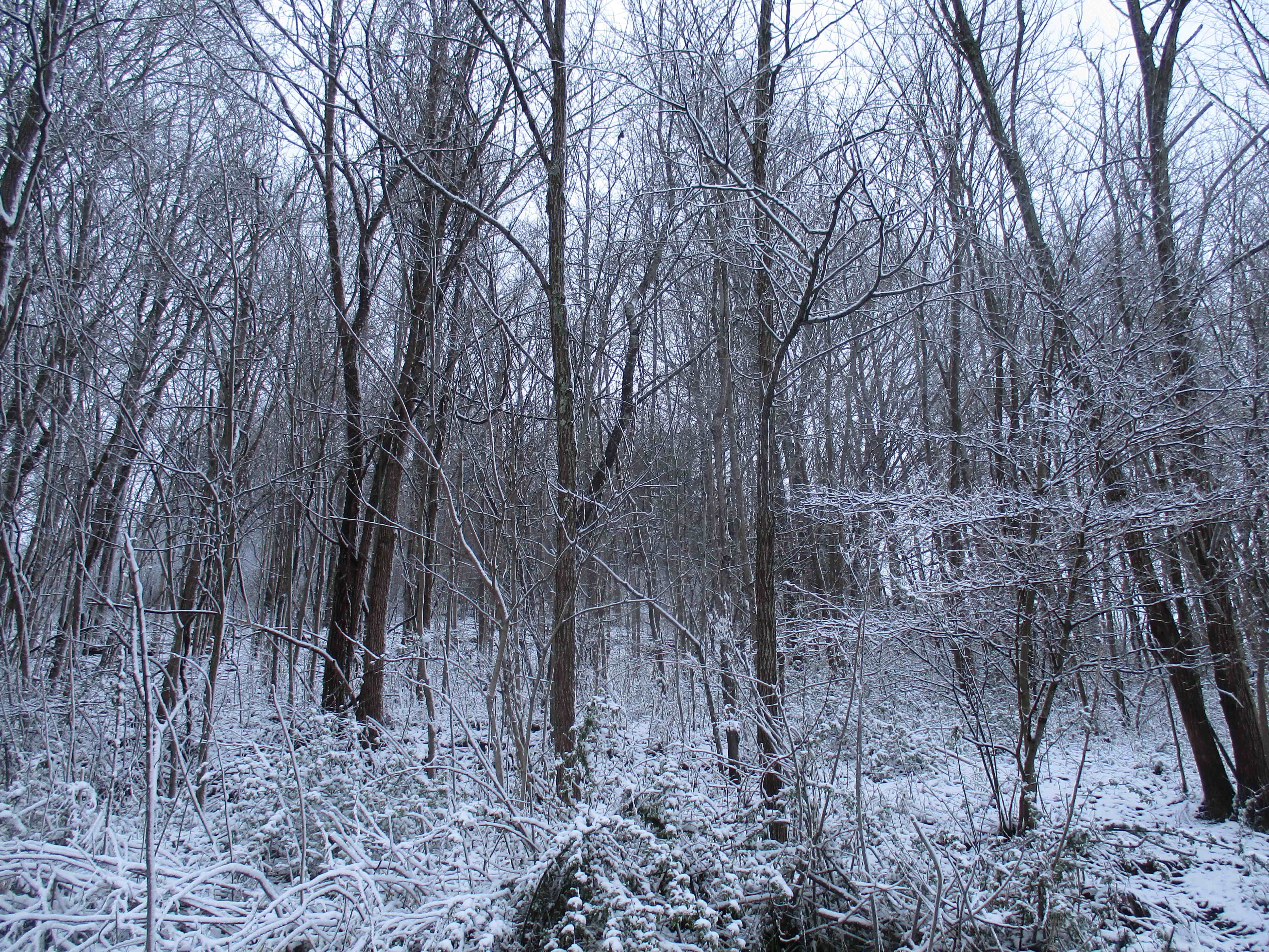
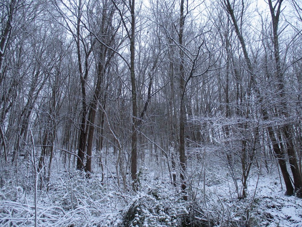
The HRRR looks to be right. I have got about 3/4ths of an inch on the ground. The wet snow certainly makes it seem more than that though with how well it stuck to the trees. I may send a picture soon. Another 1/4th of an inch and I can call it an inch even.
- 225 replies
-
- 2
-
-
- mountain snow
- thunderstorms
- (and 5 more)
-
I think I will retire for the night a quarter inch of snow has accumulated thus far as my final observation of the night. The temperature remains a steady 32 with light snowfall. A burst of moderate/heavy snow at this point would likely turn the roads white for a short time. It was enjoyable to observe and I guess my goal for the night was achieved in spite of the temperature woes.