SnowDawg
-
Posts
1,253 -
Joined
-
Last visited
Content Type
Profiles
Blogs
Forums
American Weather
Media Demo
Store
Gallery
Everything posted by SnowDawg
-
Could the timing of this strong westerly wind burst in the pacific with the cold coming finally be our luck turning? Should beef up the subtropical jet quite a bit, and no surprise that the models are looking much more active in response.
-
Yeah, gotta hope at least somebody gets something out of it. All this time tracking for it to whiff the entire southeast would just suck lol. Ensembles last night looked promising for the 4th week of the month but get me inside 3 days and maybe I’ll feel okay about it.
-
I’m gonna try to bring an ounce of positivity as I go to bed. Despite the GFS/NAM being stupid and jumping all the way off the storm on today’s runs, a lot of the other data is actually on a steady move west. Canadian and its ensemble, Euro AI, AI GFS and ensemble, and more. As bad as the GFS was at 0z, the GEFS ticked back west. Lastly the Euro itself and its ensemble did as well. I’m not ready to jump off the cliff yet on this one, it’s still too close. Probably won’t happen in the end, but we’ve gotten NW trends of this magnitude inside this timeframe before. Euro AI trend as an example.

-
Just too dang weak and positive tilted to throw enough precip back west. So frustrating… Also looks like the bigger runs this morning had a bit of a Pacific jet injection and that is trending down, so less overall moisture in the system.
-
I’ll be honest, it burns me up that while simultaneously screwing us in the south it’s trending wetter for New England. So it actually is moving west but, yet again, for the thousandth time in the last 4 years it is trending towards being too late of a bloomer for us. What happened to lows forming in the northwestern gulf?
-
Well guess it’s just the NAM and its replacement vs everything else. What could go wrong?
-
Stronger and better tilt at H5 that time for sure. Would expect a bit more precip to the NW than it showed for the mtns and foothills. Overall a positive move. Maybe a sign that the GFS steps back that direction at 18z as well.
-
Webb is sticking to his guns on a last second northwest move. I guess we’ll see.
-
Yeah I’d say almost none of the models really moved east much in that cycle, but everything trended flatter and weaker. That ain’t gonna cut it for (almost) everyone. More amped is probably also slower since it’d wanna turn the corner instead of slide straight out to sea. We can worry about temps when we actually get something to fall.
-
The longer it goes on the more it feels like something is broken in a way we aren’t going to get back. A historical average of 4-8 per year and having never had a year on record without at least a trace, to suddenly go almost 3 full years with none. And it would be 4 full years with none if not for a couple inches of wintry mix slop last January.
-
Flatter is the main trend seen so far. Makes sense given the progressive flow and has been the overall theme of the past few years. More times than not flatter, drier, and disorganized wins lately.
-
NAM didn’t really jump east but it did come in flatter there. Hopefully thermals will work out here on that Friday night/Saturday morning activity because I think that may be my best shot. Unless Euro starts making big jumps soon, I expect to be dry for Sunday.
-
Dude has changed dramatically in the past year or so. Idk if the station or something has pressured him to drive engagement or what, but it’s become incessant with the hype posts. Still a good Met but this has made me distrust him some.
-
Truly don’t understand how the surface depiction is that bad there… It’s a tiny bit more positive tilt than GFS but otherwise they are quite close at H5 to me.
-
Idk whether to be excited or scared that this trend ain’t gonna stop soon.
-
Well, NAM was way way different than the 18z GFS at the same hour. It’s the 84 hour nam though so who knows what that means really.
-
https://arctic.som.ou.edu/tburg/models/?model=era5&base=500relvort&background=plain&state=states_brown&country=countries_brown&proj=conus&archive=false&run=2021012700 This site has a reanalysis of the 2014 storm talked about, and many others if anyone is interested. Menus take a minute to figure out but a lot of great storms to look at on there.
-
Yeah I don’t actually even disagree with this but these last 4 winters has zapped my ability to have any optimism I think.
-
Plenty of other Mets disagreeing with Webb on that though. NW trend is possible for sure, but I’m not sure how much given the overall progressiveness of the pattern, and some of us need a lot. Seeing 0 members with qpf at my location was a gut check.
-
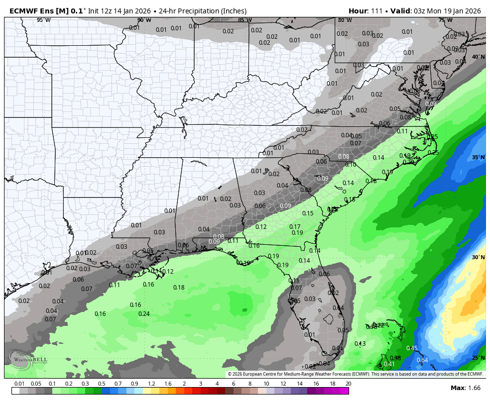
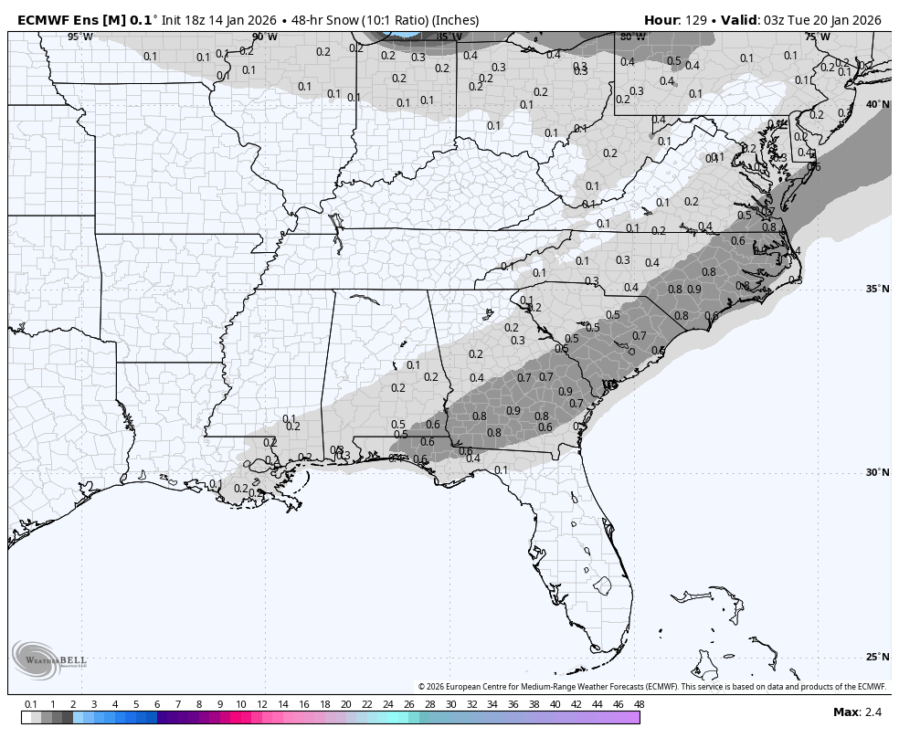
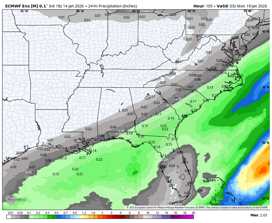
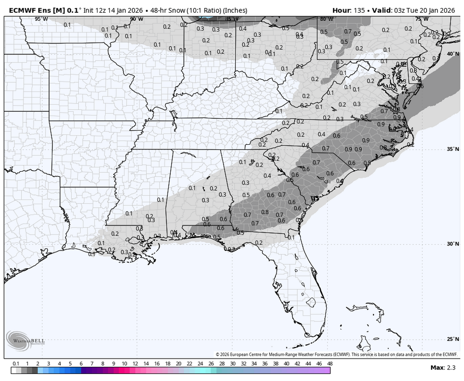
QPF 12z followed by 18z. And snowfall mean 12z followed by 18z

-
EPS is not positive. Fine for those from the FL panhandle to SE VA though. EPS is the gold standard in my book and unless it starts making big changes in the next 24 hours I’d bet that those of us to the north and west will end up disappointed yet again.
-
Much improved in all areas of interest at H5. Better separation from the wave behind plus better ridges in front and behind. Get the entire long wave trough axis to go a bit more neutral/negative and it’ll go boom. Still wouldn’t be shocked to see a bit more precip response to the NW even with that look.
-
OP was a tick towards the Euro at H5 but the GEFS continued to move NW. Will have to dive into the members more to see whether or not that’s just being skewed by some amplified outliers.
-
Just what I was going to say. Orientation is more similar to the Euro but it is a good bit further west. Ultimately it would’ve been the next few frames that really would’ve mattered with how it rounds the base of the trough.
-
Yep that’s where I’m at. I’d love to see things move towards a GFS solution but ultimately the same fail modes that caused the system moving in now to miss are still there. No blocking and no 50/50 means things are very progressive and flatter positive tilt is a serious risk.