SnowDawg
-
Posts
1,253 -
Joined
-
Last visited
Content Type
Profiles
Blogs
Forums
American Weather
Media Demo
Store
Gallery
Everything posted by SnowDawg
-
 I don't really understand those snowfall outputs in North GA from model sites that are supposed to be taking sleet out, yet the majority of that adds up while it's showing sleet?
 -
1/10-11 super awesome winter SE OBS thread
SnowDawg replied to strongwxnc's topic in Southeastern States
25/14 Clear, calm, and cold. Think we might beat the forecast low of 24. -
Yeah GSP dropped my total as well by riding the NAM. Can't say they're wrong, but I am skeptical of it. Not saying I buy the HRRR/GFS with their 6-8 totals down here but I do think the NAM and SREF start mixing way too quick, based on historical experience. Closer to 4 or so with an inch of sleet and maybe a glaze feels more likely to me, as a compromise between the different model camps.
-
It seems even among the short term models the NAM is on an island right now. HRRR, GRAF, RGEM, Fv3, and RAP all look rather similar with regards to storm evolution. They also make more sense historically for the mtns foothills area in regards to a snow to sleet back to snow scenario that we've seen a thousand times. I'm not one to discount the NAM lightly, but these can't ALL be that wrong can they?
-
I guess I'm just riding with the Euro whether it's to glory or off the cliff. If these thermals ruin everything for North GA after sitting in the bullseye for over two days I'm gonna be depressed for a bit I think.
-
Didn't even come close to the forecast high of 43 today here. Hit 35 an hour ago and starting to drop off now.
-
It looks increasingly likely, though, that the Upstate won`t escape at least a small amount of ice, and that zones as far north as I-40 will be under the gun for some sleet. Dreams of an all-snow forecast? Quashed. Looks like GSP definitely not going with the Euro/Ukie/RGEM camp that don't have sleet getting anywhere near I-40.
-
Man, those NAM thermals are soul crushing for as good as things have looked for North GA over the past 48 hours. Only saving grace for now is I don't think these CAM models are reliable at the end of their range. Still showing at 18-24 hours out then might as well throw in the towel.
-
My only concern is if we start this trend now how far is it gonna go? A little drier is fine, but remember we are going to use up a decent chunk of our qpf just on moistening the column with dewpoints being as low as they are going to be.
-
South and weaker, less qpf... Time for those nerves to set in.
-
Nam was really juicy honestly, and generally upped QPF across the south east up to the same hour as the 18z run ended. It was definitely warmer though, thus all the ice.
-
Wish the Euro would quit being such a thorn in the side when it comes to qpf.
-
NAM a little more amped therefor warmer aloft that run, but stronger CAD and much colder at the surface.
-
Hey, you're real close by right across the state line. Spend every day I can in the summer fishing down at the Chattooga on either 76 or 28. Generally if we do well over here then your area does as well, although we do have a bit better elevation.
-
I haven't looked at soundings to confirm this but it could be an elevated warm layer skewing the thickness values. Warm in the sense of relative to expected, but still isothermal. This is a snippet from Meteorologist Jeff Haby's page explaining. He's using 540 but I'm sure the same would apply to the general rule of 546 in the south. "For example, WAA can occur between 800 and 650 millibars, which causes the temperature in that layer to increase and thus results in the thickness increasing above 540. If the temperature between the surface and 650 millibars continues to stay below freezing, the precipitation will fall as snow." http://www.theweatherprediction.com/habyhints/97/
-
Seems like both GFS and Euro are making small adjustments toward one another each run. Middle ground scenario seeming likely for now.
-
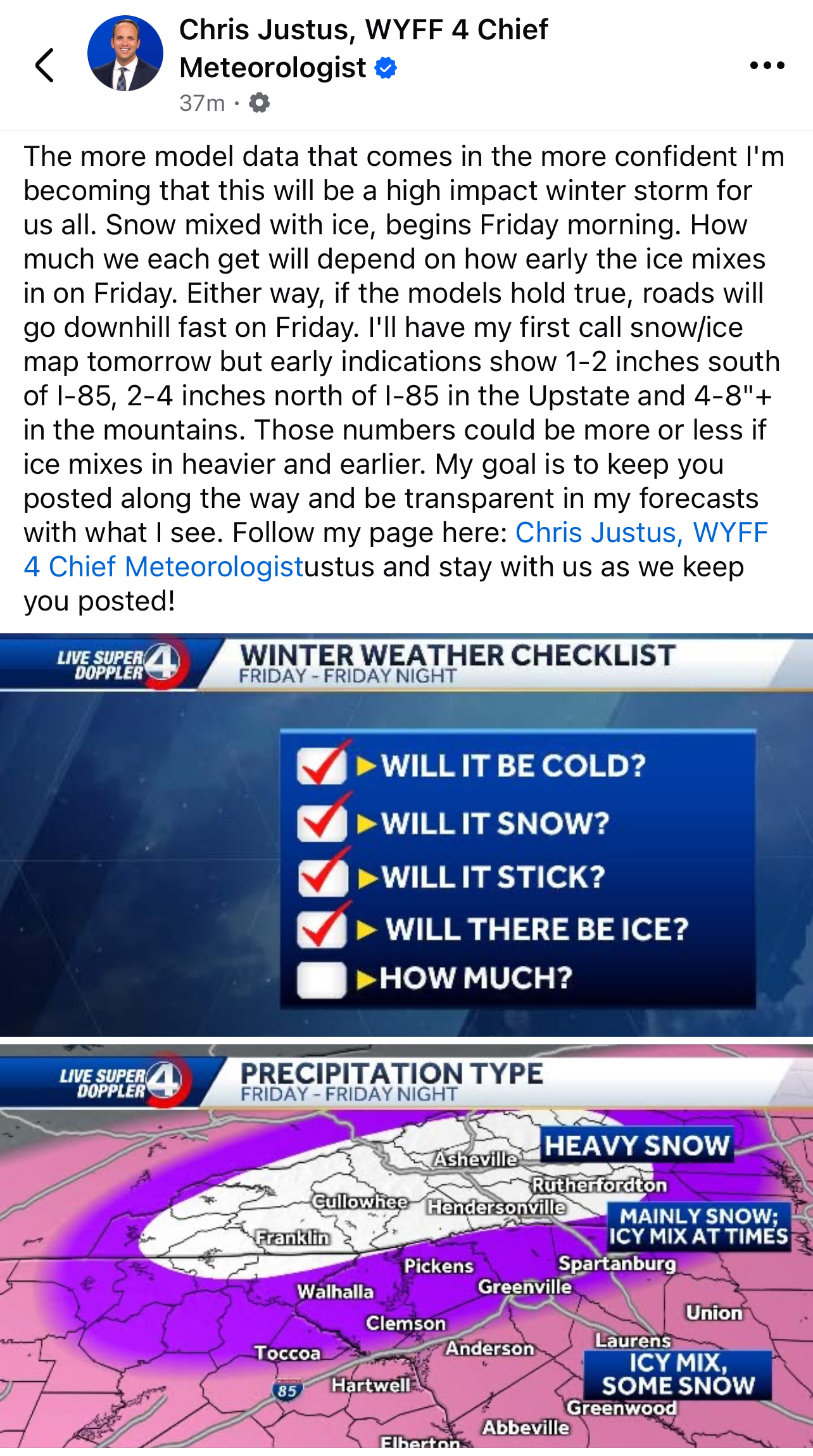
Chris Justus at WYFF in Greenville, admittedly a fellow weenie, is going all in tonight.
-
At this range I'd consider those run to run changes on the GFS as almost negligible. At 18z it was a western outlier from its ensemble suite, let's see if that continues tonight.
-
Leaves a bunch of energy behind and shears out as it moves east. Huge foot plus snow storm all the way to North Mississippi and then just falls apart. Here's hoping it's wrong, but I think we're past the range where we can just say the Euro has a bias to leave energy behind and write it off. GFS also has a tendency to over-amplify the northern stream, so safe bet for now seems to be somewhere between the two.
-
Give me an amped solution with a slightly better track and I am thrilled. I'll happily take it as is, but if we're allowed to be picky that's my request lol
-
Another change I liked, across I believe all guidance, was the axis of snowfall out in Texas/Arkansas running more east/west.
-
Euro is actually much colder in the mid-levels than the GFS was just need better rates. I wouldn't expect as wild of run to run swings from the Euro, but at least it was a tick in the right direction.
-
Yeah, I think I've mistakenly been hoping for a weaker system to reduce warm air advection, but all the weak runs are terrible. Stronger runs are pulling more cold air from nearby into the system. I'm fine with a messy winter storm, I mean that accounts for like 95% of our events, but I'd really like to score nicely on that front end before the mixing starts. GEFS also jumped considerably colder at 850 compared to 6z.
-
H5 was improved on the GFS, I'll take that and move on to the next runs. Better phase with the northern energy improved the mid-level thermals and made the front end thump last longer.
-
I'll just say, and this is not analysis of any kind, but I'd say that kind of freezing rain is rarely that widespread and I'll belive it when I see it. Better/deeper low level cold from the snow pack to the north could give us a ton of sleet which I'll take any day over zr.