

SnowDawg
-
Posts
1,253 -
Joined
-
Last visited
Content Type
Profiles
Blogs
Forums
American Weather
Media Demo
Store
Gallery
Everything posted by SnowDawg
-
-0.5 this morning is definitely one of the coldest mornings I've seen in long time down here. I think even back in 2014 we only got to the low single digits.
-
Probably one of the better all snow events I've had since at least the mid 2010's if not earlier. Most of our 6+ events have mixing at some point.
-

January 30th- Feb 1st ULL and coastal storm obs
SnowDawg replied to JoshM's topic in Southeastern States
Looks to be mostly done here. About 7.25. No wind at all still really. Should start blowing and drifting later this evening. -
January 30th- Feb 1st ULL and coastal storm obs
SnowDawg replied to JoshM's topic in Southeastern States
21.7/19.3 south of Clayton, GA. Right at 7 inches now. Another band building in to the east let's see if I can get under it! -
The “I bring the mojo” Jan 30-Feb 1 potential winter storm
SnowDawg replied to lilj4425's topic in Southeastern States
Short range models were showing that yesterday. It being largely calm in the vicinity of that meso-low and then ramping up into the evening hours. -
The “I bring the mojo” Jan 30-Feb 1 potential winter storm
SnowDawg replied to lilj4425's topic in Southeastern States
I could believe it. Winds have largely been calm up here. My highest gust of the day so far has only been 9mph. -
January 30th- Feb 1st ULL and coastal storm obs
SnowDawg replied to JoshM's topic in Southeastern States
21.7/19.8 south of Clayton, GA. Between 6.5 and 7 inches. Rates have finally slacked up with the flow changing a bit more due north. -
January 30th- Feb 1st ULL and coastal storm obs
SnowDawg replied to JoshM's topic in Southeastern States
22/20.2 South of Clayton GA. Convective band with huge flakes just back building overhead. Everytime it looks like it's gonna slack up it gets going again. Just shy of 6 inches now. Over an inch in the last 30 minutes. -
Little convective band just rolled in here and it is absolutely dumping. Quarter size flakes and reduced visibility even with little to no wind.
-
January 30th- Feb 1st ULL and coastal storm obs
SnowDawg replied to JoshM's topic in Southeastern States
22.2/20.4 south of Clayton, GA. 4.75 inches now. 1.75 in the last hour. -
January 30th- Feb 1st ULL and coastal storm obs
SnowDawg replied to JoshM's topic in Southeastern States
24.4/22.7 South of Clayton GA. 3 inches so far. At 7:30 there was only a half inch. -
January 30th- Feb 1st ULL and coastal storm obs
SnowDawg replied to JoshM's topic in Southeastern States
24.8/22.9 Around an inch between Tiger and Clayton GA. -
Wonder why the big changes on the west side of the forecast area? Pretty sure I've seen reports of around 2 inches already in Murphy.
-
Checked one last time before getting a little sleep and starting to get a few flurries.
-
Haha, wow! Definitely saving that one. Maybe the biggest fantasy storm.ever for my back yard lol.
-
Yeah dry air is a pain right now. Steady returns for an hour or more yet the humidity has dropped quite a bit. Nothing to worry about for now though I don't think. Would've just been a bonus. My NWS grid didn't even have accumulating snow til after 2-3 AM.
-
NAM and to some extent the Icon there continue to have me spooked, but man have we longed for times like these....
-
The “I bring the mojo” Jan 30-Feb 1 potential winter storm
SnowDawg replied to lilj4425's topic in Southeastern States
12km says less than an inch, 3km gives me 6-8. Glad things are clear as mud this close to the storm lol -
The good thing with that is that's not necessarily something the CAMs should have a good handle on at this range I don't think. Probably should lean on the globals until they lock in on a synoptic scale setup, and then use the mesoscale models for localized features once things are settled up top.
-
The “I bring the mojo” Jan 30-Feb 1 potential winter storm
SnowDawg replied to lilj4425's topic in Southeastern States
It nailed the lower QPF this past weekend though. -
The “I bring the mojo” Jan 30-Feb 1 potential winter storm
SnowDawg replied to lilj4425's topic in Southeastern States
I just can't confidently believe in the Euro totals in GA and upstate with the NAM/RRFS continuing to be so dry. -
The “I bring the mojo” Jan 30-Feb 1 potential winter storm
SnowDawg replied to lilj4425's topic in Southeastern States
Hard to tell at this point what are trends and what are just windshield wiper wobbles. GFS jumped back up but we lost the Candian/RGEM. Gonna be an interesting 24-48 hours. -
The “I bring the mojo” Jan 30-Feb 1 potential winter storm
SnowDawg replied to lilj4425's topic in Southeastern States
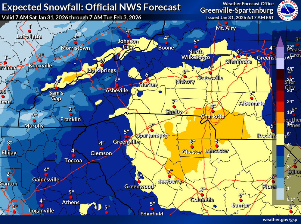
NAM and GFS Continue to worry me greatly for NE GA and the upstate. I want to lean on king Euro but NAM and GFS match up with what the GSP discussion had to say about the western half of the forecast area. -
The “I bring the mojo” Jan 30-Feb 1 potential winter storm
SnowDawg replied to lilj4425's topic in Southeastern States
Every model but the GFS and NAM are starting to look really solid for Ne GA and the upstate. I'd still take the GFS solution too but it's way too close for comfort. -
The “I bring the mojo” Jan 30-Feb 1 potential winter storm
SnowDawg replied to lilj4425's topic in Southeastern States
The splotchy presentation in Ne GA and the upstate continues to scream downsloping unfortunately.


