SnowDawg
-
Posts
1,253 -
Joined
-
Last visited
Content Type
Profiles
Blogs
Forums
American Weather
Media Demo
Store
Gallery
Everything posted by SnowDawg
-

The “I bring the mojo” Jan 30-Feb 1 potential winter storm
SnowDawg replied to lilj4425's topic in Southeastern States
Looks like small ticks south and west in the mean low position are definitely on the table if those far eastern outliers are eliminated. -
That run right there is what every single person on this board deserves. Foothills and upstate deserves this win! Reel it in.
-
The “I bring the mojo” Jan 30-Feb 1 potential winter storm
SnowDawg replied to lilj4425's topic in Southeastern States
Wow 18z euro.... I'm still not all in on this but that run is enticing me lol -
The “I bring the mojo” Jan 30-Feb 1 potential winter storm
SnowDawg replied to lilj4425's topic in Southeastern States
Would love just a bit more dig on the ULL there. Worry about downsloping across the smokies here with that trajectory. -
The “I bring the mojo” Jan 30-Feb 1 potential winter storm
SnowDawg replied to lilj4425's topic in Southeastern States
How good are the models at accounting for virga in the total QPF output? On the western side we'll be fighting for every tenth of an inch we can get so that will matter. -
The “I bring the mojo” Jan 30-Feb 1 potential winter storm
SnowDawg replied to lilj4425's topic in Southeastern States
Still having power/internet/cell service problems here so I'm not able to see any models for this one. Can load one page of this thread in like 5 minutes lol. Any chance this thing can get going in the northern gulf a little sooner? Tired of being fringed by every single event except for ice storms apparently. -
The “I bring the mojo” Jan 30-Feb 1 potential winter storm
SnowDawg replied to lilj4425's topic in Southeastern States
Definitely gonna need more moisture back this way than the Euro showed not to just lose all of it to virga given how dry the initial airmass is going to be. -
I wanna see how the grid looks here after this wind tonight before I get excited for that. I want a snow bad, but I'm not sure we'd be ready to handle that one so soon. Definitely not very far out though. Google model showed same look and it was first to lock in to this one at 6 days out.
-
Southern Crippler - Get well soon Jimbo Storm Obs
SnowDawg replied to BooneWX's topic in Southeastern States
I just desperately hope people prepared for the cold around here and got secondary heat sources. Already near 80% out of power and the wind ain't even really started yet. -
Southern Crippler - Get well soon Jimbo Storm Obs
SnowDawg replied to BooneWX's topic in Southeastern States
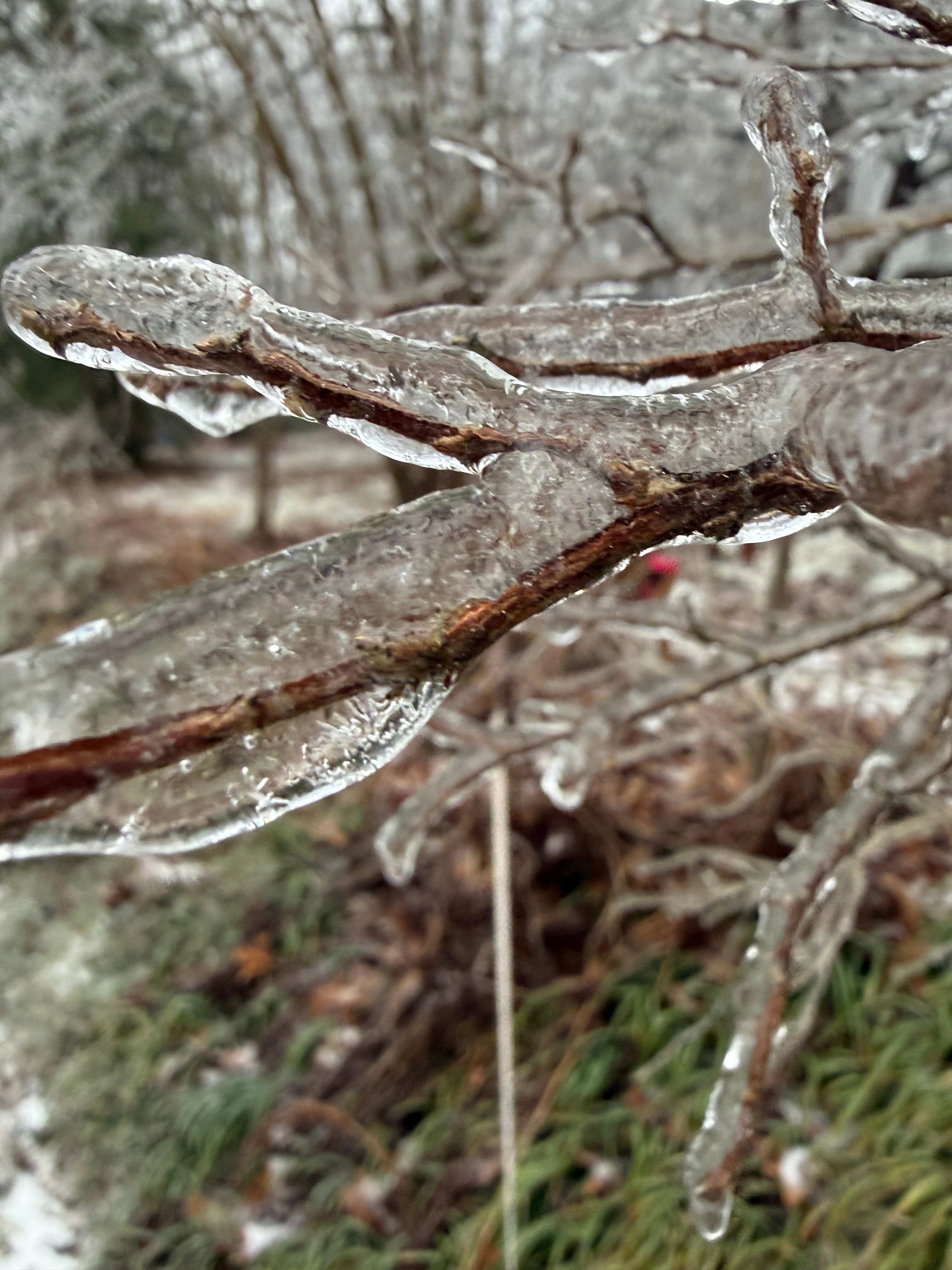
Really is, I've heard from folks in Jackson County area that it's been nothing but sleet the whole time for the most part. I've seen nothing but freezing rain since like 6 this morning. And even last night it was mixed with ZR. I had between a Qtr to half an inch already by like 9-10AM. -
Southern Crippler - Get well soon Jimbo Storm Obs
SnowDawg replied to BooneWX's topic in Southeastern States
Things are going to get real bad here when the cold front arrives late tonight into the morning. I think we've just got barely above 32 with this heavy precip pushing the warm air down, but there's got to be at least 0.5 to 0.75 built up. I don't really know honestly, alreqdy had a tree almost fall on me during helene so I ain't about to go check. Can't imagine what it's gonna sound like when the winds get up to 30-40mph -
Southern Crippler - Get well soon Jimbo Storm Obs
SnowDawg replied to BooneWX's topic in Southeastern States
Both maybe. It will all depend on your exact temp. Part of county will likely be just above freezing by then part not. No guarantee on thunder but definitely a stronger line of convective showers than seen so far regardless. -
Southern Crippler - Get well soon Jimbo Storm Obs
SnowDawg replied to BooneWX's topic in Southeastern States
Over 60% without power in Rabun county and rapidly going up. Even with a brief period just above freezing likely later, I'm very concerned about how things get when the heavy winds arrive. -
Southern Crippler - Get well soon Jimbo Storm Obs
SnowDawg replied to BooneWX's topic in Southeastern States
Freezing rain will just not let up here. Trees/branches are starting to pop at a frightening pace so I'm done walking out to try and measure but I'm confident it's well over a half inch now. -
Southern Crippler - Get well soon Jimbo Storm Obs
SnowDawg replied to BooneWX's topic in Southeastern States
Stayed wintry mix over night mostly, but has been off and on heavy freezing rain with drizzle in between this morning. Adding up fast as are the power outages.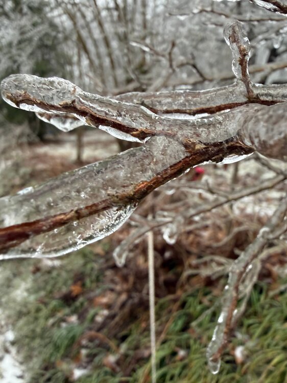
-
At my folks house taking care of them on the south side of Rabun county (Wiley). Just crossed the freezing mark at the surface and steadily dropping. Only the brighter returns are making it to the ground for now, but unfortunately all liquid. Afraid this one is gonna be really rough here...
-
Southern Crippler - Get well soon Jimbo Storm Obs
SnowDawg replied to BooneWX's topic in Southeastern States
Snow sleet mix here. 35 degrees but imagine it'll start wet bulbing down. -
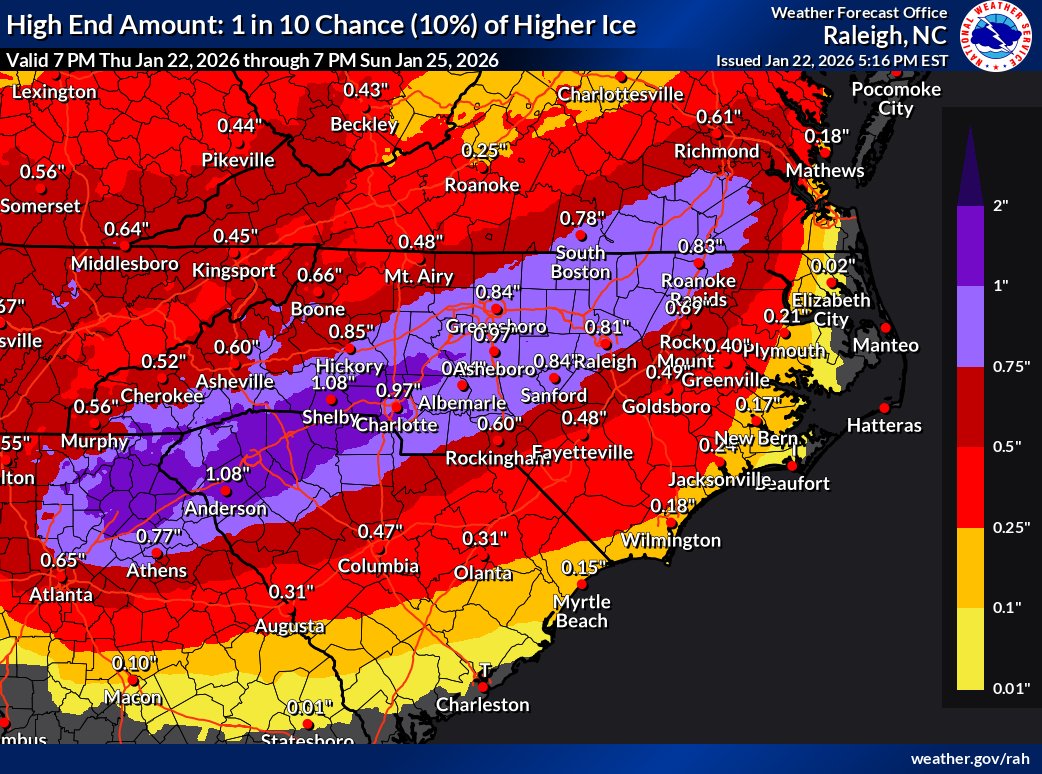
Yeah this was my thinking. Temps are usually a bit more borderline than this when we see ZR. Plus wind makes accrual more efficient. Could be more like 0.6 to 0.75 depending on localized conditions.
-
If that warm nose ends up at +10 degrees or more like some models have shown there ain't nothing stopping that. At that point it's all about that surface level wedge being deeper for sleet.
-
SW NC mountains start to get out of the CAD wedge too the further you go, which is the primary source for the low level cold needed for sustained freezing rain.
-
So nice to finally see a classic I-85 corridor winter storm again. This region has been screwed over for too long now. Oh, wait no....

-
More phasing and higher heights in the east on the mean. Not sure I'd call that better at all.
-
Just to rain on the parade a bit, The AI GFS and GEFS went slightly the other way at H5. Lots of members in both camps though so we track on.
-
Yeah the other models really have already moved that way to an extent, they all just have a much further starting point than the GFS to get back to positive for us.
-
Only thing that makes me feel this has a chance to actually at least move partially in that direction is that this has essentiallly been what every system has done for a few years now. As we get closer the northern stream gets more progressive and stronger and suppresses the flow in front of the weaker sheared southern wave. Thorn in our side all those times before but could be our saving grace this time. IF we can get it to keep trending.