SnowDawg
-
Posts
1,253 -
Joined
-
Last visited
Content Type
Profiles
Blogs
Forums
American Weather
Media Demo
Store
Gallery
Everything posted by SnowDawg
-
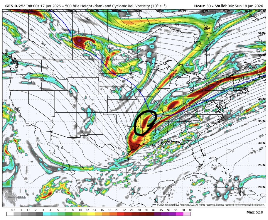
Since we should have CAD this go around too, when is the last time it hasn’t trended stronger/colder the closer we get? Seems like as long as the HP is there the CAD verifies deeper and colder than modeled and saves a lot of us in that region from significant ZR.
-
GFS AI slowly but surely catching on to the strength of the HP. The AI models almost act like ensembles as far as smoothing things out, just smoothing against historical data as opposed to other members.
-
I don’t really know what to think at this moment. I still think physics based models are better suited here than AI this time because of the AI tendency to underestimate high intensity, be it LPs or HPs. But they are always learning, and that very bias could be lessening as they ingest more data. Really sucks to be sitting here with the best overall solution being the GFS again though. Seen that movie one too many times lately. But please just give me sleet or a warm rain above all that ice.
-
Hard to be upset with where any of the major ensembles are at this point but clearly a number of scenarios ranging from cutter to varying degrees of snow and ice are on the table. Could be the first threat of several to close out the month as well.
-
If the HP is actually at least close to as strong as the other models are showing, I don’t think the AI models will handle this one well. They tend to underestimate extreme anomalous lows/highs because there aren’t enough examples of them in their training data. The other models being physics based know that, while rare, 1050ish highs can absolutely happen this time of year. We need a combination of strong high pressure and a weak (but not too weak lol) overrunning type system. Any combination of weaker high or super amped up storm hurts us.
-
Seems like BAM and a few others aren’t buying the southern shift for next weekend and think it’ll be more of a southern Great Lakes/Ohio Valley system. Up until those 12z runs I definitely thought the same, that next weekend would largely be north of us and a stage setter for multiple chances in the week that follows.
-
My thinking is that we all should’ve known better than to fall for a handful of GFS/NAM runs but we did anyway. Outside of that I actually think today’s event was fairly well modeled. South/Central GA appeared to be the bullseye at a decent lead time and it proved true. That being said I’ll absolutely temper my expectations, but if the EuroAI/Euro/EPS are all in as we move forward then there ain’t gonna be no stopping my excitement lol.
-
If that look actually came to pass there would be more snow/sleet further south and less freezing rain than it is showing. Let’s reel it in!
-
Excluding flow snow in the mtns, Euro AI had 4 separate snow events from the 24th-31st. And was the 8th straight run with a storm centered around the 28th.
-
If the blocking and 50/50 being advertised actually develop over suppression may be our biggest potential fail mode. Hopefully one of those big cutoffs can slide under the ridge out west and time up well.
-
Got down to 37 here during that but the snow level stayed just above my head. I’d say most above 2200 to 2500 saw snow during that heavier bit that came through here. All modeling keeps the next round well to the east so guess it’s on to the end of the month. Still not even a stray flurry so far this winter…
-
Euro AI at least is showing blocking and a 50/50. If that actually happens, then it won’t have much room to move north. That’s a big if though.
-
Euro AI operational is on 7 straight runs now with widespread accumulating snow on a single storm signal 27th-29th.
-
43.9/25.1 Gonna take a miracle with the front or really good rates here I’d think.
-
I’m getting February 2021 nightmares cause I swear that was the last time the models looked this good for a period. We were seeing massive fantasy storms then the rug got pulled, the trough dumped all the way into Northern Mexico, and we watched 2-3 big storms cut west of us.
-
I would say NAM is west and juicer with that initial finger, but is east/weaker with the heart of the system. If the temps workout, the finger could be out best hope. Preferred where things were heading at 6z with the northern piece of energy phasing more and getting the entire system oriented more N/S so that the pivot off the Atlantic coast was closer to us.
-
Looks like both AI models hit again. That’s like at least 3-4 in a row for the Euro AI.
-
Man, when was the last time we saw this many different models honking about the same period at this range? Hate to get my hopes up about a period 10+ days out but hard not to with how consistently it’s showing across multiple suites.
-
Could just be a blip. They like to waffle back and forth at times. The more north/south the orientation is the better for us and it bumped just a tad more east/west there.
-
NAM was a bit flatter that run. The question will be whether that becomes a trend or just a blip, and it’s gonna windshield wiper back later today.
-
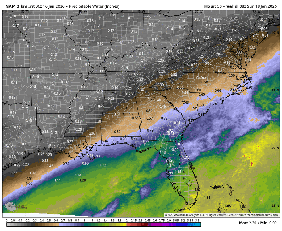
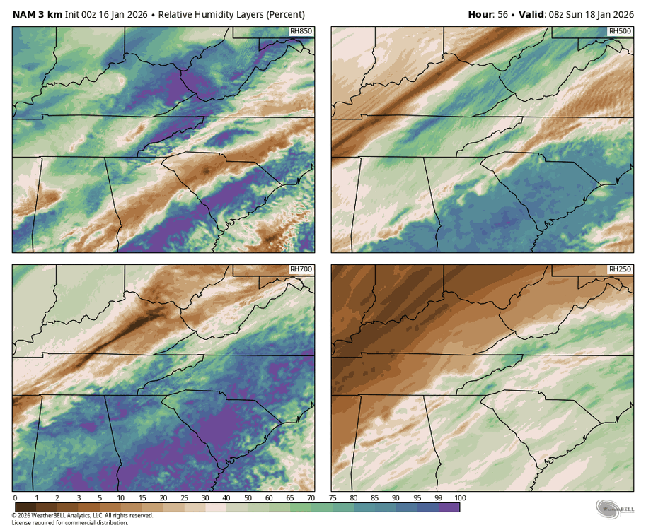
Trend is clear as day on the NAM. The angle of moisture fetch off the gulf has improved dramatically. I think the NW portion of that precip shield is likely under-modeled as well. Between the terrain and the sloped arctic front aiding in lift, it won’t take a ton of moisture to squeeze something out further north and west. Still too early to feel confident in it, but who woulda thought this time last night that we’d still be in the game? Precipitable water values trend on NAM 3km.
-
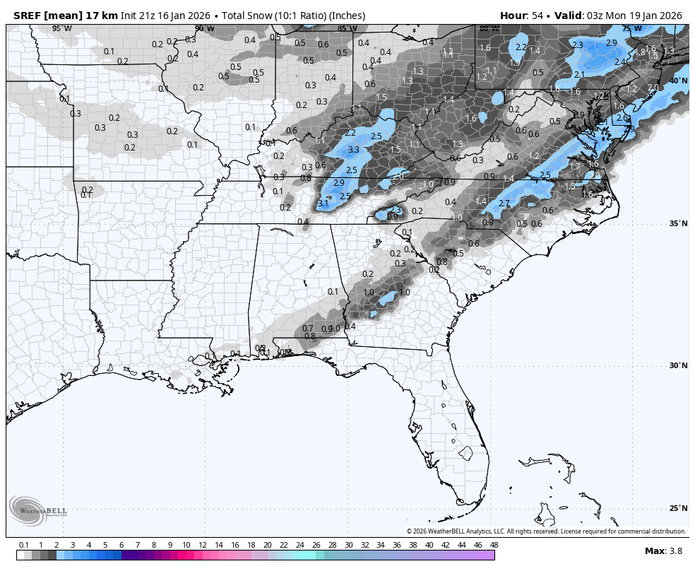
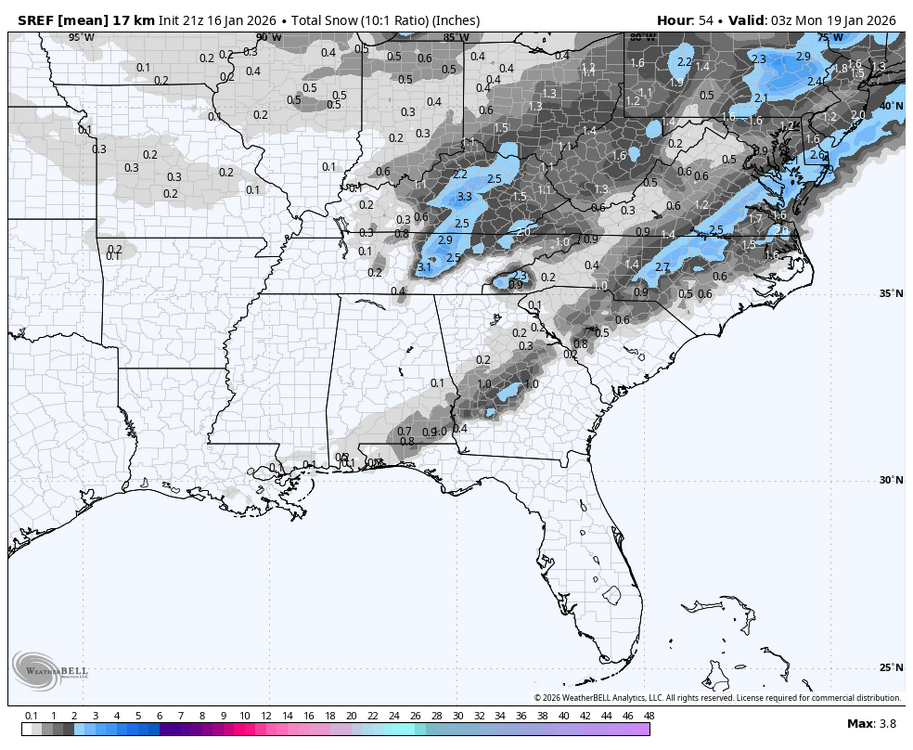
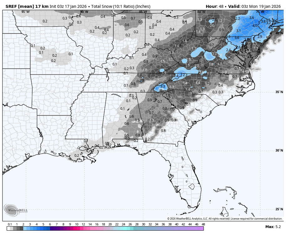
New SREF mean vs 21z. Never been that impressed with the SREF but interesting nonetheless. Old New
-
One thing that stuck out to me on that NAM and GFS run was this piece of energy is phasing with the southern part of the shortwave when it was not before. This amps the system up a bit more, earlier formation of the low pressure, and more lift to the north and west. Need 2 or 3 runs of trends back my way but could very well put a lot more people back in the goods. Now if Dr. No will just agree.
-
Great trend for the mtns and foothills with the moisture transport on NAM 3km. Still need a bit more but as we know in these situations the far western extent of the precip shield is sometimes underestimated from the moisture being pushed up and over the arctic front. Unbelievably, I think we’re still in the game with a small chance.
-
Yep and the arctic front being more past us than to the east could give some isentropic lift over the shallow cold air. Still unlikely, but it really won’t take much shallow moisture to maybe create a bit of qpf.