SnowDawg
-
Posts
1,253 -
Joined
-
Last visited
Content Type
Profiles
Blogs
Forums
American Weather
Media Demo
Store
Gallery
Everything posted by SnowDawg
-
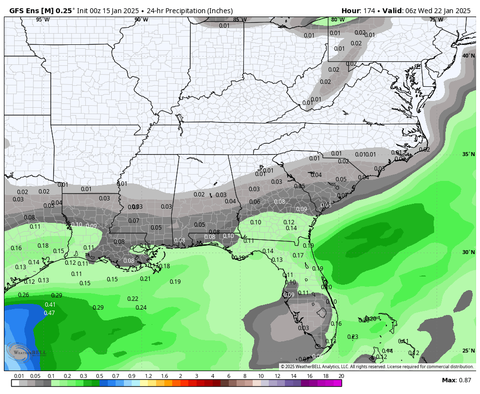
I am not betting against the EPS at this range. I am expecting dry weather for N GA, Upstate, and W NC. Hopefully we can hold on to the CAD long enough for the late week chance.
-
Yeah, yesterday's 4 run NW trend was clearly a head fake. Deep south/coastal areas definitely in a good spot right now I'd say. Further inland chances a certainly decreasing for anything significant, at least from wave 1. At the very least it'd be nice to get an inch or two of high ratio powder on the northern fringe.
-
If you're on well water, fill your bathtubs up to use for flushing the toilets. The power packs/charging hubs are definitely great for keeping your devices going. As for powering a fridge I wouldn't know without more research. I never owned a portable generator until I lost who knows how many dollars worth of food during Irma and vowed to never let that happen again.
-
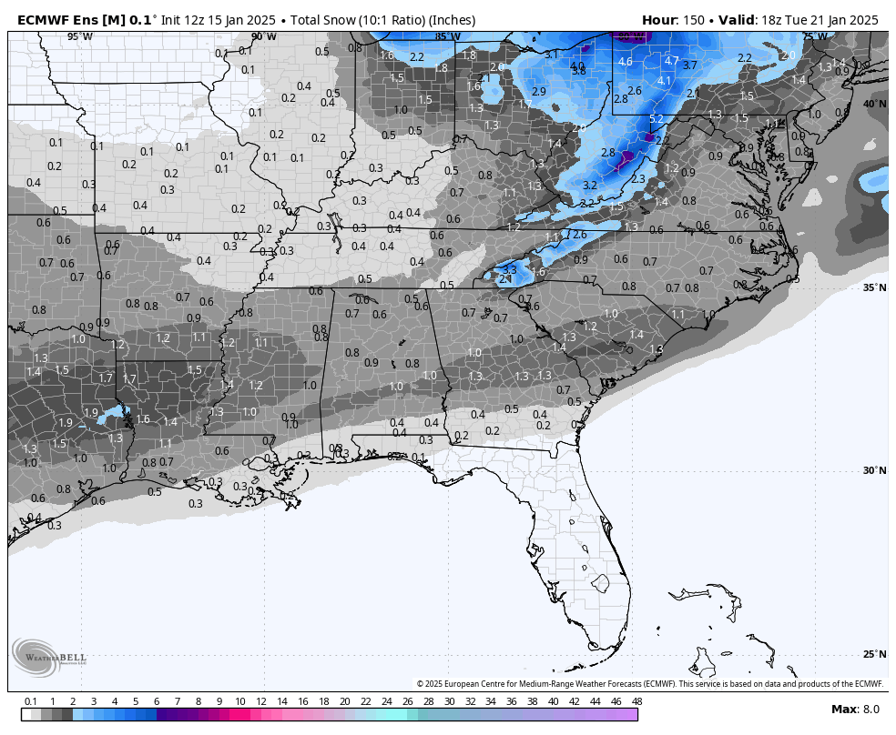
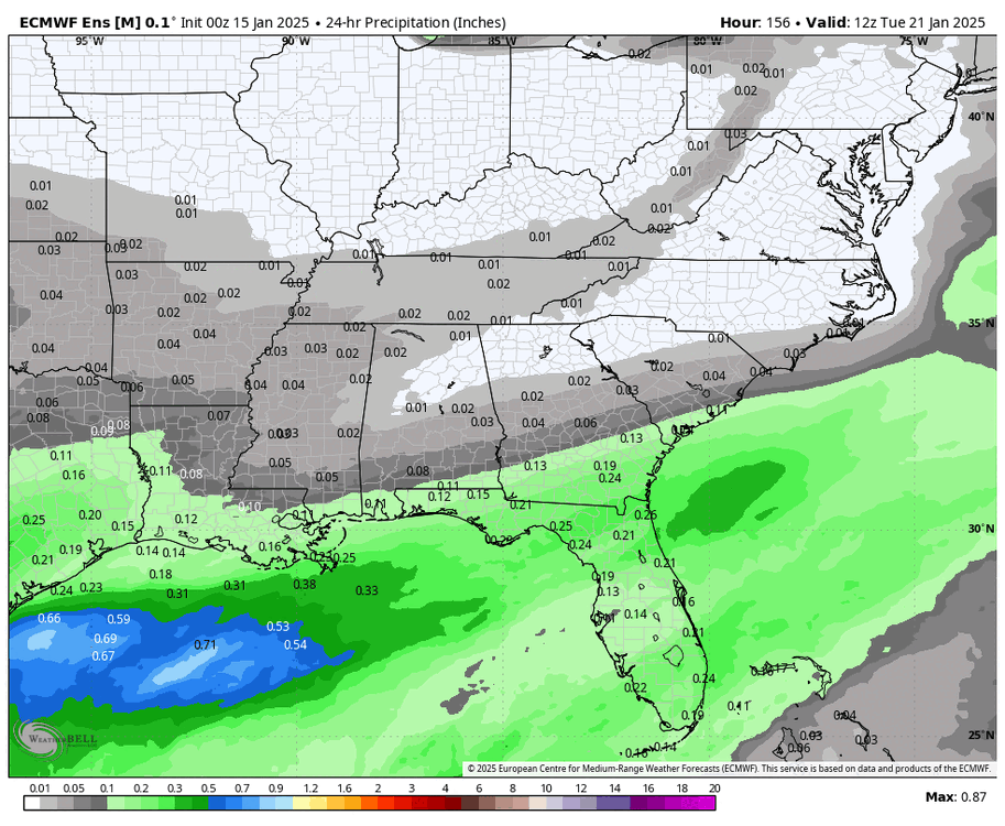
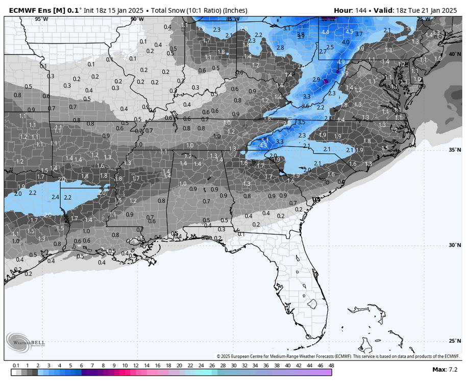
Similar story on the EPS, although across fewer runs because the mid cycle runs being only 144 hours.
-
I wouldn't say there is no NW trend showing but it certainly isn't as aggressive as usual. Despite the run to run variance of the OP GFS, the GEFS is clearly trending north with the precip for the early week threat.

-
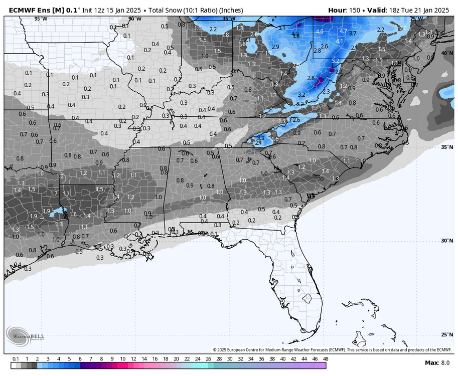
18z EPS Old 12z run. Keep in mind as well that because of the hr144 cutoff the event is still underway when this stops, otherwise totals would be even higher.
-
This for sure. I feel like we started tracking last weeks threat window shortly after Christmas. I think I'm still trying to catch up on sleep from all the last minute model chaos from that one.
-
We went through the dry suppressed look on the ensembles last time too. Give it time and see if the cold push actually verifies to the extent being shown. More often than not it moderates with time which also tends to pull the moisture back north. We should only be signal hunting at this range, and cold air looks to be around with moisture in the Gulf. Time to play the waiting game again.
-
Even acknowledging the sort of unpredictable luck with that band setting up in Atlanta, the NAM completely busted in the rest of North GA until finally getting a clue morning of the event. The rgem and the Euro both showed the warm nose changing us to sleet, and then going back to snow. Albeit the changeover on those two being an hour or so too slow. No model was perfect for the region as a whole, but overall I'd bet the Euro probably scored best which should probably come as no surprise.
-
Hi-res nam was absolute garbage in the SW mountains, GA, AL, MS, and TN. Its 18z run the night before the event still wasn't showing any snow in North GA, AL, or MS and incorrectly showed mixing way too far north in TN. Euro and RGEM were far superior to the NAM and it wasn't even close, I don't understand the praise it is getting.
-
Looks to me on the ensembles that the 3rd week of January definitely has some potential just gotta see where things go from here. Kind of has an arctic boundary/zipper low type look to it on the GFS.
-

1/10-11 super awesome winter SE OBS thread
SnowDawg replied to strongwxnc's topic in Southeastern States
Final total is impossible to measure here in Tiger, GA due to all the sleet and freezing rain compacting the previous snow. Ultimately, we've got a crusty 3 - 3.5 inches so I am estimating around 4-5 inches of snow/sleet fell all together with a glaze to a tenth of zr. -
The NAM didn't nail anything from NE GA westward. It had pretty much no snow falling at all in North GA or Alabama until like 12 hours out. It had significant mixing going all the way to the TN/KY line. For this area RGEM/Euro were far superior, with HRRR a bit behind but still very good.
-
Went through those bands in North GA too a while ago. Definitely best rates of the day. Put down another half inch on top of the crusty 3 that was there. Went out and enjoyed a little night sledding. Feels great to break the streak, now maybe we can land us a big dog before January is over with!
-
Absolutely dumping sleet here now with some snow mixed in. This should pile up if it keeps up.
-
Right at two inches maybe a bit over here in Tiger. Folks at GSP couldn't have forecasted better. Called for snow then sleet after 2, and have just switched over to mostly sleet in the last 5 minutes.
-
I've just been looking at both 850 and 700 and assuming there's a slightly warmer layer somewhere between.
-
Based on HRRR it is more elevated than that. Between 850 and 700 so unfortunately is gonna be a bit hard to track on the SPC maps.
-
I've seen reports of sleet and freezing rain all the way into Dawsonville area.
-
Not loving reports of how fast the warm nose is working north in parts of GA. Was hoping to get to at least 3 or 4 this afternoon before going over to sleet but I'm not so now.
-
Crazy to see that frontogenesis band is stretching all the way to the South Carolina coast right now with some mping reports of a mix or even snow around Charleston.
-
Have seen reports of nearly 3 inches in west Atlanta suburbs (Paulding county) and a friend in McDonough south of the city saying there is at least an inch.
-
Congrats! You definitely made the right decision.
-
Still waiting to saturate here, but hopefully shouldn't be long as better rates are slowly starting to push in.
-
That band SW of Atlanta is putting down accumulating snow in places that haven't seen it in a long time. Have seen reports of heavy snow covered roads as far as 50+ miles south of Atlanta.