Chicago Storm
-
Posts
18,917 -
Joined
-
Last visited
Content Type
Profiles
Blogs
Forums
American Weather
Media Demo
Store
Gallery
Everything posted by Chicago Storm
-

Pre-Christmas (Dec 21-23rd) Winter Storm
Chicago Storm replied to Chicago Storm's topic in Lakes/Ohio Valley
Notable changes on the 0z NAM... Ridging both ahead and behind the main through is flatter, and the main through does not dig as much. Makes sense that run turned out the way that it did. -
Pre-Christmas (Dec 21-23rd) Winter Storm
Chicago Storm replied to Chicago Storm's topic in Lakes/Ohio Valley
It pumps up better ridging immediately ahead of the trough, but further ahead things end up a bit flatter overall. This, along with changes in the Pacific/West Coast, are some of the reasons we have seen a slight shift east in the track (And other changes). -
Pre-Christmas (Dec 21-23rd) Winter Storm
Chicago Storm replied to Chicago Storm's topic in Lakes/Ohio Valley
That is most definitely one of the changes, actually briefly mentioned a change in Canada earlier...and that's it. As you can see in your animation, that alters heights ahead of the main trough/wave. -
Hawaii issues their own watches.
-
Pre-Christmas (Dec 21-23rd) Winter Storm
Chicago Storm replied to Chicago Storm's topic in Lakes/Ohio Valley
Unfortunately the Gulf feed is not the best, due the the wave moving through the Deep South/Gulf Coast over the next few days. -
Pre-Christmas (Dec 21-23rd) Winter Storm
Chicago Storm replied to Chicago Storm's topic in Lakes/Ohio Valley
Izzi went all out in his AFD. I definitely would not have at this point. -
Pre-Christmas (Dec 21-23rd) Winter Storm
Chicago Storm replied to Chicago Storm's topic in Lakes/Ohio Valley
Event underway there in about 48 hours or less, so it makes sense. The surprising one is IND already going with a WSW. I'm guessing they're giving more than usual lead time, given the upcoming holiday travel period. -
Pre-Christmas (Dec 21-23rd) Winter Storm
Chicago Storm replied to Chicago Storm's topic in Lakes/Ohio Valley
The changes we saw with the 12z suite (Even part of the 6z suit) made sense, given what's going on in the larger scale. Overall, there has been a trend towards less digging of the trough as it moves through the Western/Central US, due to some changes over the Pacific and up in Canada. This leads to a somewhat weaker storm system initially, later deepening, an eastward shift in track and a loss of some of the more significant solution output. A thing to watch is if this trend continues or is reversed over the next 24 hours or so. As we continue to move through today and tomorrow, more sampling of all of the moving pieces will occur. By the time we reach tomorrow evenings 0z runs, we should have a locked in idea on how it will all go down. -
Pre-Christmas (Dec 21-23rd) Winter Storm
Chicago Storm replied to Chicago Storm's topic in Lakes/Ohio Valley
12z guidance trend has been to have the trough move into the region further north initially, leading to a delay in when things amp up. In turn you get a bump east in the track and a weaker storm system initially. -
Pre-Christmas (Dec 21-23rd) Winter Storm
Chicago Storm replied to Chicago Storm's topic in Lakes/Ohio Valley
.
-
Pre-Christmas (Dec 21-23rd) Winter Storm
Chicago Storm replied to Chicago Storm's topic in Lakes/Ohio Valley
That was... A significant solution. -
Pre-Christmas (Dec 21-23rd) Winter Storm
Chicago Storm replied to Chicago Storm's topic in Lakes/Ohio Valley
Insider info says Tuesday would be the day, if things hold. -
Pre-Christmas (Dec 21-23rd) Winter Storm
Chicago Storm replied to Chicago Storm's topic in Lakes/Ohio Valley
There are several pieces the the puzzle that are being sampled today and tomorrow. However, the main wave is being sampled today/tomorrow over Alaska, and then will be sampled over SW Canada and the Pac NW on tomorrow/Tuesday once again. -
Pre-Christmas (Dec 21-23rd) Winter Storm
Chicago Storm replied to Chicago Storm's topic in Lakes/Ohio Valley
. -
Pre-Christmas (Dec 21-23rd) Winter Storm
Chicago Storm replied to Chicago Storm's topic in Lakes/Ohio Valley
12z EPS bumped west as well, actually favor NW of the OP Euro. -
Pre-Christmas (Dec 21-23rd) Winter Storm
Chicago Storm replied to Chicago Storm's topic in Lakes/Ohio Valley
Perhaps slightly, but definitely much closer to reality. -
Pre-Christmas (Dec 21-23rd) Winter Storm
Chicago Storm replied to Chicago Storm's topic in Lakes/Ohio Valley
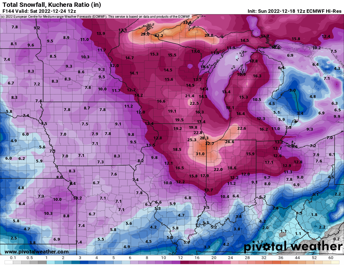
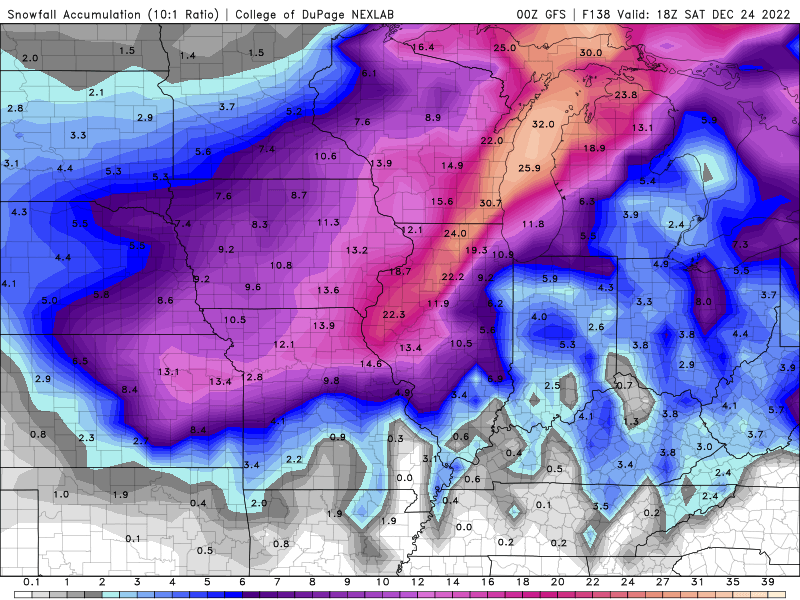
As many have said, 10:1 maps will be closer to reality, but for lolz...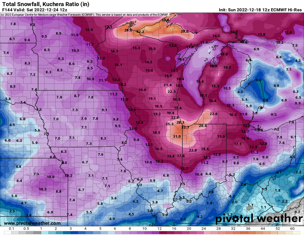
-
Pre-Christmas (Dec 21-23rd) Winter Storm
Chicago Storm replied to Chicago Storm's topic in Lakes/Ohio Valley
12z Euro will make a bump back west as well, not that it has significantly changed in the past day or so. . -
Pre-Christmas (Dec 21-23rd) Winter Storm
Chicago Storm replied to Chicago Storm's topic in Lakes/Ohio Valley
Still a few days away from that. Should current guidance pan out... Lead snow chances possibly as early as Wednesday night, but main system snow generally Thur/Fri. -
Makes sense, with a developing +EPO/+PNA pattern.
-
they have always been pretty bad.
-
Pre-Christmas (Dec 21-23rd) Winter Storm
Chicago Storm replied to Chicago Storm's topic in Lakes/Ohio Valley
12z UKMET also with a jump back west once again. Evolution aloft is different, so the SLP actually tracks from Des Moines-Chicago-Detroit. . -
Pre-Christmas (Dec 21-23rd) Winter Storm
Chicago Storm replied to Chicago Storm's topic in Lakes/Ohio Valley
The 12z GFS is a full out blizzard, with 50-70KT at 925mb on the backside of the SLP. This would lead to surface wind gusts of 50-70MPH. . -
Pre-Christmas (Dec 21-23rd) Winter Storm
Chicago Storm replied to Chicago Storm's topic in Lakes/Ohio Valley
12z GEM with a big jump back west as well, after the hiccup east on the 0z run. Trough digs in much further west and is slower, allowing the the Canada lobe to retreat north and increase ridging ahead of the main wave/trough. . -
Pre-Christmas (Dec 21-23rd) Winter Storm
Chicago Storm replied to Chicago Storm's topic in Lakes/Ohio Valley
The digging further south is kind of a mirage. The main wave is more so coming in digging a bit further west, with better trough tilt. Also a bit more ridging ahead of the wave/trough across the Eastern US, and better separation between the main wave/trough and the lobe in S Canada. .