

ma blizzard
-
Posts
3,059 -
Joined
-
Last visited
Content Type
Profiles
Blogs
Forums
American Weather
Media Demo
Store
Gallery
Everything posted by ma blizzard
-
not every day you see something like this
-
Honestly don’t mind running in the cold like this .. after a mile I’m always warmed up no matter how cold. Bigger problem is the icy sidewalks / roads
-
Sure we all want a KU but I also wouldn't mind a legit arctic blast to set some records, especially with deep snowpack in place
-
Looks like that is the all time record low for ORH? Must have been some serious fake cold to put up a 24/-24 on the day 2/9/1934 only other sub -20 min on record and 2/-20 on the day
-
good 'ol Eames hall
-
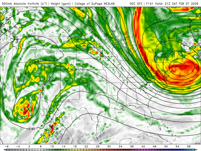
Possible coastal storm centered on Feb 1 2026.
ma blizzard replied to Typhoon Tip's topic in New England
can't wait for that inevitable run of the NAM that shows a region wide blizzard followed by a clean whiff within a couple model cycles -
Possible coastal storm centered on Feb 1 2026.
ma blizzard replied to Typhoon Tip's topic in New England
could be an all timer if you shift the ULL northeast like 100 miles .. so close to being an amazing look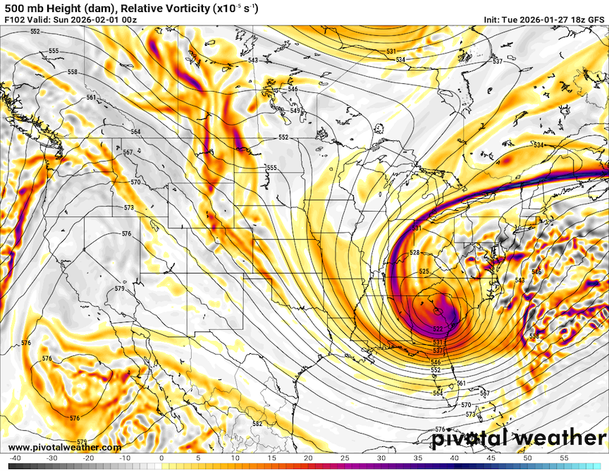
-
Possible coastal storm centered on Feb 1 2026.
ma blizzard replied to Typhoon Tip's topic in New England
Thinking the ULL closes off later and ends up tracking further NE? -
January 25-26th, 2026 Final Storm Totals
ma blizzard replied to The 4 Seasons's topic in New England
20.6" in Shrewsbury .. in line with the report from a NWS met close by in Westboro who had 21" 1.85" melted down, QPF over performed BOX PNS finally updated and just taking a peak at the totals for Worcester county, looks like a lot of reports are too low. Not sure what's going on but no way the report for Shrewsbury (13.6") is accurate .. even as a depth measurement at the end of the storm. -
low of -6 this morning, impressive considering it took til past 3 am for temps to drop below 10 wonder if we can pull a -10 min this week
-
3.2” of fluff since 5 pm
-
eyeballing a little over 2” since 5 pm
-
should be a lesson for the people expecting the kuchera snow maps to verify
-
5/1, S+ roads are a mess .. almost took out a mailbox or two on my coffee run
-
“Cory’s in LA! Let’s MECS!” Jan. 24-26 Disco
ma blizzard replied to TheSnowman's topic in New England
Don't worry we will take plenty of pictures for you -
January 2026 regional war/obs/disco thread
ma blizzard replied to Baroclinic Zone's topic in New England
kinda resembles the storm after march 01 at 500 anyway -
31.6/29 S- 3.3"
-
“Cory’s in LA! Let’s MECS!” Jan. 24-26 Disco
ma blizzard replied to TheSnowman's topic in New England
theres the high end evolution -
impressive rates with good snow growth .. wasn’t expecting this
-
January 2026 regional war/obs/disco thread
ma blizzard replied to Baroclinic Zone's topic in New England
19.4" -
January 2026 regional war/obs/disco thread
ma blizzard replied to Baroclinic Zone's topic in New England
12z Euro might be overdoing the 2m temps a bit Would be very impressive if this verified
-
Rise of the Machines: January 18-19 Winter Storm Obs Thread
ma blizzard replied to WxWatcher007's topic in New England
just under 3” so far -
Another Coating of Snow Saturday - "It's all we Got"
ma blizzard replied to Sey-Mour Snow's topic in New England
all you can do is laugh as we are getting surgically shafted going on 4 years now .. -
January 2026 regional war/obs/disco thread
ma blizzard replied to Baroclinic Zone's topic in New England
get that pv lobe to phase in sooner and its probably the best cinema of the year -
March '13 is probably the most egregious example of this


