KeenerWx
-
Posts
866 -
Joined
-
Last visited
Content Type
Profiles
Blogs
Forums
American Weather
Media Demo
Store
Gallery
Everything posted by KeenerWx
-
Winter 2025-26 Short Range Discussion
KeenerWx replied to SchaumburgStormer's topic in Lakes/Ohio Valley
Looking like we’ll struggle to squeeze an inch. Onto the next. The good news is that there seems to be several upcoming swings at the plate. -
2.1” here so far, with probably a few tenths left to go. Good stuff.
-
Still looking good locally for 2-4”. Hopefully someone cashes in on some fgen magic. These smaller events are fun in their own way.
-
Winter 2025-26 Medium/Long Range Discussion
KeenerWx replied to michsnowfreak's topic in Lakes/Ohio Valley
Looking like a 1-3/2-4 shot across portions of the sub on Monday. Perhaps a more substantial punch on table for southern and eastern portions. Gotta love every chance to bury the not so distant past of excruciatingly long and boring stretches. -
Nov 28-30th Post Turkey Day Winter Storm
KeenerWx replied to Chicago Storm's topic in Lakes/Ohio Valley
9.2” here. Still snowing lightly but about wrapped up. Memorable storm for sure. It’s a winter wonderland outside. -
Nov 28-30th Post Turkey Day Winter Storm
KeenerWx replied to Chicago Storm's topic in Lakes/Ohio Valley
Pretty spot on with your call, then. Where did your competitor measure? On the ball atop a flagpole? On a plowed road? -
Nov 28-30th Post Turkey Day Winter Storm
KeenerWx replied to Chicago Storm's topic in Lakes/Ohio Valley
On the doorstep of 7”. Another slug of heavier stuff about to move in, though, so we should still get to 8. -
Nov 28-30th Post Turkey Day Winter Storm
KeenerWx replied to Chicago Storm's topic in Lakes/Ohio Valley
Just crossed 5”. Still stacking, so 8” should be within reach. Pure bliss outside. -
Nov 28-30th Post Turkey Day Winter Storm
KeenerWx replied to Chicago Storm's topic in Lakes/Ohio Valley
~3” so far. Quality heavy snow right now. A little concerned about the slottage that has meandered throughout NC IL but seems to “fill in” before getting too close to here. -
Nov 28-30th Post Turkey Day Winter Storm
KeenerWx replied to Chicago Storm's topic in Lakes/Ohio Valley
Not much has changed from my thoughts locally over the past 24 hours. Hoping we hold steady, even as that dry slot influenced “custom screw zone” (cyclone, 2025) gets way too close for comfort. For a final call would expand the upper range and go 3-7”. Aside from total failure, I don’t see going below 3”. But imo would take a lot of things going right to get to 7”. Moving chips up a bit to 5.7” -
Nov 28-30th Post Turkey Day Winter Storm
KeenerWx replied to Chicago Storm's topic in Lakes/Ohio Valley
Yanked some stats for Kankakee County because they have done especially incredible compared to climo this November. While I don’t live there, I can geek out about random stats. Now, consider that this data comes from COOP reports. It’s justified to question some data especially as we reach further back. But it’s what we’ve got. Pulled 1925-2025 from reporting locations nearest to Kankakee. Top 5 Snowfall: Month of November Some locations in Eastern Kankakee County have already notched 2025 as #1 or will soon do so. The rest of the county will likely place at #2, with real possibility of taking #1 if things break right. 1951 - 12.3” 1959 - 9.8” 1932 - 7.2” 1950 - 7.0” 2015 - 6.3” Gamma distribution would suggest roughly along the following periods for each breaking point in total November snowfall: 8” - 1 in 35 years 12” - 1 in 75 years 16” - 1 in 150 years 20” - 1 in 300+ years Needless to say, the upcoming snowstorm will likely push the county into historic+ proportions for the month of November. Especially the eastern portions of the county where the highest breaking points are achievable. Top 5 Snowstorms: Month of November Here again areas in eastern parts of the county already notched a likely #1. The rest of the county can put these on watch to surpass. November 6-7, 1951 - 9.0” November 12-14, 1959 - 8.0” November 15-16, 1932 - 7.2” November 29, 1942 - 6.0” November 21-22, 2015 - 6.3” Finally, it looks nearly certain that the county will grab two 4”+ events in the month of November, which hasn’t ever happened from what I gathered. Soliloquy over. Carry on. -
Nov 28-30th Post Turkey Day Winter Storm
KeenerWx replied to Chicago Storm's topic in Lakes/Ohio Valley
Area wide Winter Storm Watch for LOT CWA. Last issued locally was March of 2023. -
Nov 28-30th Post Turkey Day Winter Storm
KeenerWx replied to Chicago Storm's topic in Lakes/Ohio Valley
All things considered, with fail modes still on the table, feeling pretty good about 3-6”. For the fun, will place chips on 4.8”. -
Nov 28-30th Post Turkey Day Winter Storm
KeenerWx replied to Chicago Storm's topic in Lakes/Ohio Valley
Probably 1-3” more to add depending on location. So generalized 6-10” across much of the CWA based on the map. -
Nov 28-30th Post Turkey Day Winter Storm
KeenerWx replied to Chicago Storm's topic in Lakes/Ohio Valley
Fun to track, but hard to tie any excitement locally. No real science applied to the “pessimism”, just erring on side of climo and the many fail modes favored at my specific location. On the other hand, lucked out on a record event earlier in the month. So perhaps the wins can continue. I’d be happy to just see some more snow. But as a junkie for #’s, I’m looking at the thresholds of 2”+ & 5”+. The former is just cool and gets to double digit Nov snowfall. From what I can uncover, we’ve already surpassed any reasonable verifiable record for month. The latter would mean surpassing the individual seasonal totals of ‘23/‘24 & ‘24/‘25 by end of November. Which is both silly and awesome at the same time. -
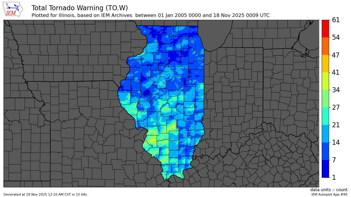
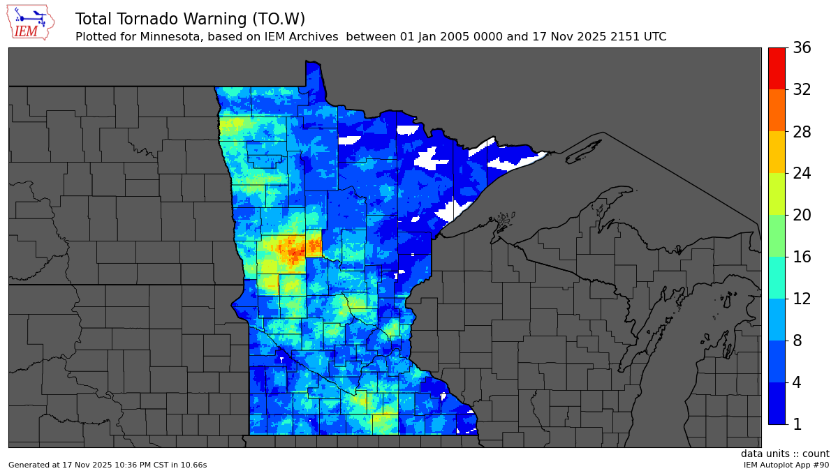
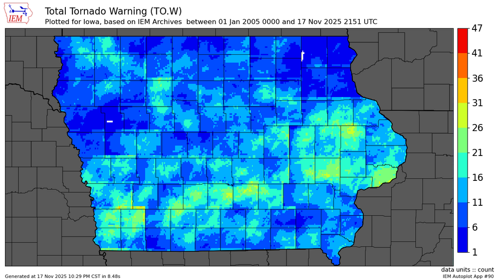
IEM is such a fun little rabbit hole to sink into. Especially when things are quiet. Looked at tornado warning counts over the past nearing 20 years (2005-2025). A few things stood out to me in particular right away. There was one small area in Illinois that has had 0 tornado warnings in the past 20 years, near Dalzell (NNW of Peru) in LaSalle County. Similarly, two small areas in Iowa that have had 0 tornado warnings in same period. One in W Winneshiek County, around/east of Protivin. The other in Ida County around Battle Creek. Indiana appeared to have full coverage over the period, which is what I’d expected from IL/IA. MN/WI/MI/OH had several gaps, but again expected given areas reaching further outside the core climatological favored areas for svr/tor. One interesting part for MN, though, was the boundary between Grand Forks & Duluth CWA. Particularly pronounced between Wadena & Cass Counties. You’ll see it immediately. There’s definitely more county boundary differences that become noticeable but that one jumped out to me quite a bit compared to the rest of the field I looked at.


-
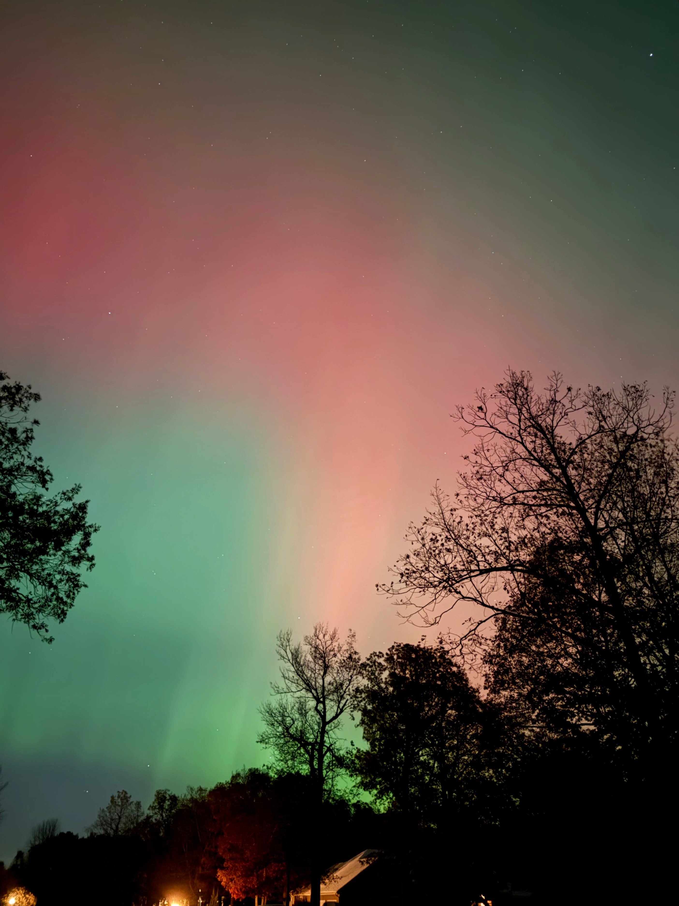
While the possibility existed, no grand finale of aurora tonight. Ingredients just did not coexist simultaneously to produce a notable show. There were some eye visible periods of reds. But compared to last night, well, it didn’t compare. Still riding the high of the past week. Quite a treat to get slammed by terrestrial and space weather in short succession. Now to settle back into a slumber and wait. Can’t get too greedy.
-
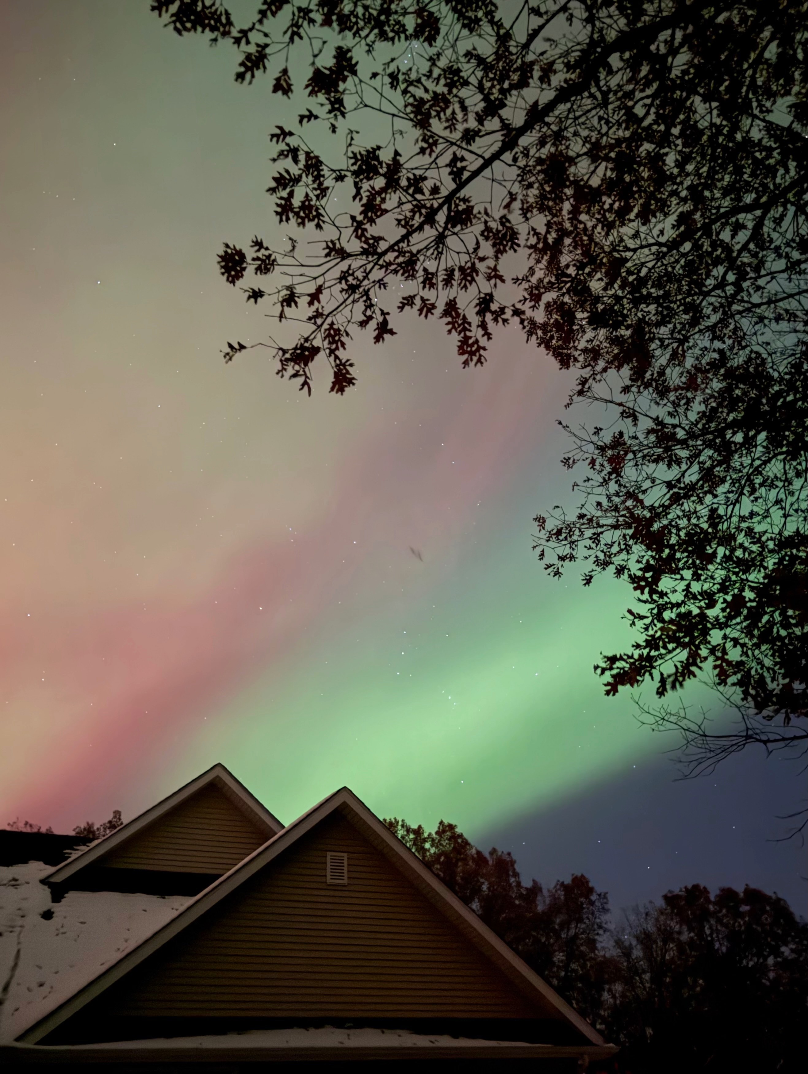
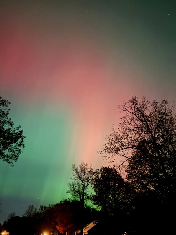
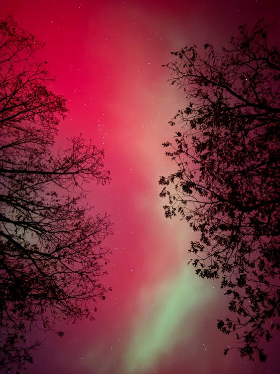
Just some more compressed iPhone pics. Possibly at risk of spamming, but this event was incredible. First was ~10:37P when things were really starting to dance. Quick movements of pillars and bleeding of vibrant reds/greens. View is to the north. Second picture is at ~10:43P and looking to the SE. The contrast of the vibrant green “snake” leader was…something. Spook-and-awe.

-
Another impact will happen from the X5 flare earlier. The impact from the X5 flare was actually forecasted to be the strongest. From the two CME’s that led to tonight’s show, forecast was for G3 @ 7+ KPI. We got to G4 @ what looks like at this point 8+/9-. Tomorrow had been forecast G4 at 8/8+. All to say, some thought is that tomorrow will end up being even more extraordinary. The downside is that (1) peak is projected during daylight hours, (2) clouds will be a problem for many in the sub during the nighttime hours.
-
-

-
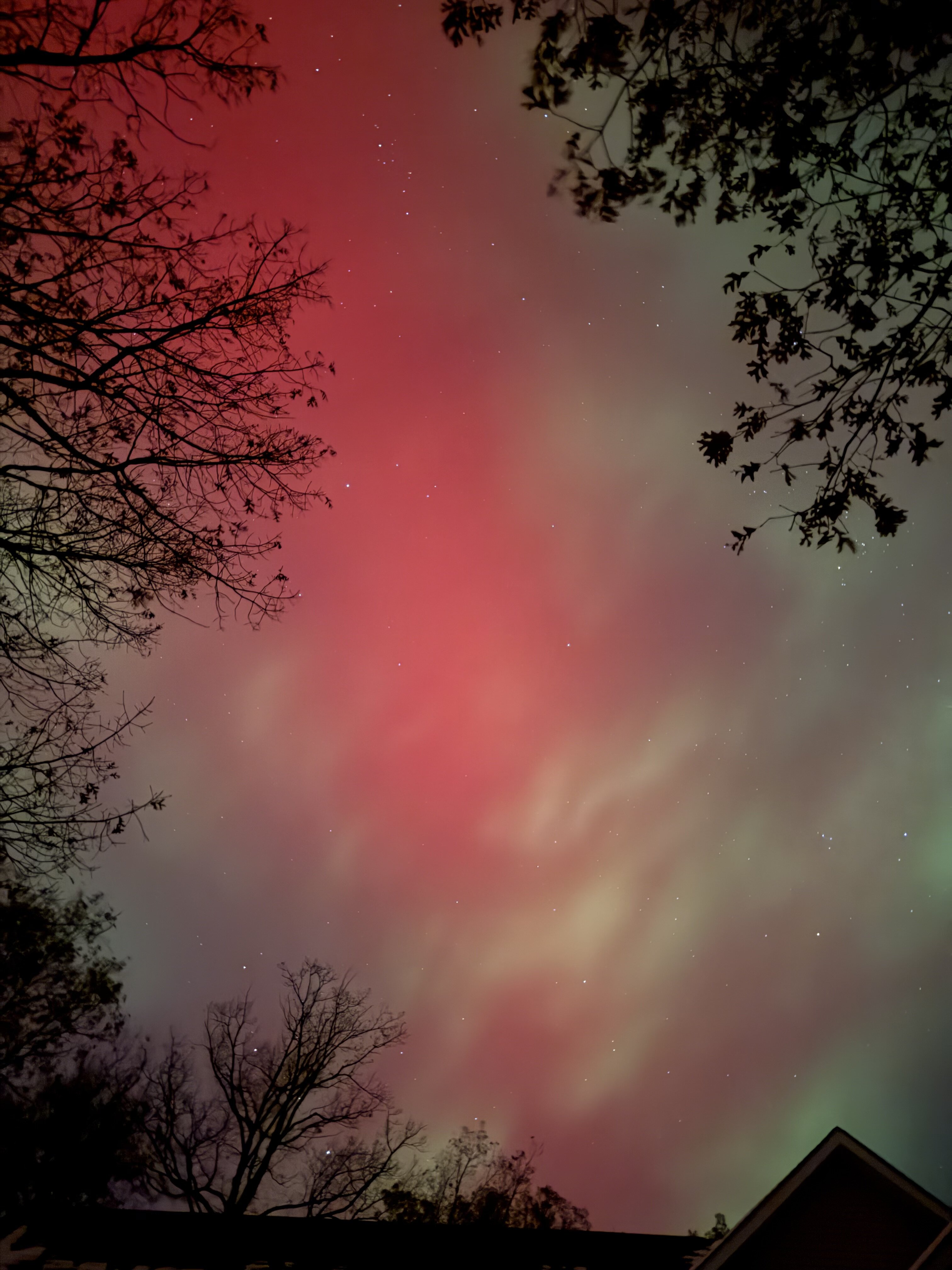
Directly overhead now in NW Indiana.
-
Aurora now naked eye visible on the horizon. Washed out haze of green and red at the moment, but we’ll see if we get any substorms that help put on a more vivid display.
-
11/8-11/10 First Snow and Lake Effect Event
KeenerWx replied to Geoboy645's topic in Lakes/Ohio Valley
Quite the middle finger pointed right into extreme SW La Porte & W Starke County. Cruel. -
For those interested in space weather, G3 conditions possible late Tuesday night into early morning Wednesday with KP index forecasted as 7+. Not unlike the most recent snow event, a lot of variables at play. And we won’t really know a lot until game time. But nonetheless, potential is there to see aurora across parts of the sub.