KeenerWx
Members-
Posts
844 -
Joined
-
Last visited
Content Type
Profiles
Blogs
Forums
American Weather
Media Demo
Store
Gallery
Everything posted by KeenerWx
-
A couple solid boomers but nothing noteworthy. Pretty satisfied that we continue to get an at-bat shot for interesting weather!
-
March def shaped up to be most exciting month since Nov, locally. Ready for boomtown tomorrow.
-
Through first half of the month: 2 SVR Watch, 1 TOR Watch, 1 SVR Warning, 1 TOR Warning & 2 High Wind Warnings. Suppose an alleged cherry on top would be some winter headline, but I’m done with snow tbh. Am entertained.
-
S tier, really. Hope we don’t pay too high of a price for it later.
-
Sucker (thankfully) missed the house by roughly a third of a mile.
-
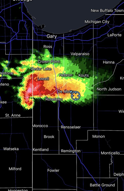
Still cellular, but slowly getting more information locally. Damage and videos show probably a few hundred yards to noticeable impact and probably less than half of a mile from considerable damage reported. Also replayed the video I took while coming out from shelter to check on the situation*. The tornado is very audibly noticeable. Boring video because it’s pitch black, but features constant roar of wind and a suction sound as the door to my patio shuts. *I’m dumb for coming out of shelter to check. It was a chaotic environment featuring me, spouse, an elderly grandparent we are caretaking, 3 dogs & 3 cats. From the moment power cut, I lost ability to monitor radar. Not even cell data would work. The couplet was clearly headed for us, and I did my best to estimate it the time it would take to clear. I was too focused on alleviating the chaos with an all clear. Lessons learned. First time I felt genuine threat from a tornado. Nerves still fried and I generally love the spicy booms.
-
I heard either the tornado or some nasty straight line winds. But thankfully no damage to the house. I was going to get out and see how close it got. But unfortunately right outside the neighborhood there’s already tree and powerline damage so I’ll have to check in the morning. Power’s out and cell service is jammed and slowwwww. I can’t even load Facebook and whatnot to see what people are sharing locally.
-
-
Yeah the lightning show is incredible.
-
Interestingly we already have sirens going off but not under any warning. Does look like we will at the very least get clipped
-
Already hearing constant rumble from her and nice CC lightning overhead. If it keeps rightward motion, may actually get close.
-
IKK cell will slide north, so locally it looks like we’ll be waiting until later tonight for any action.
-
Lake breeze went through here between 1 and 1:30. Became noticeably more chilly. But now suns out and warming back up nicely.
-
Easy 15 minute drive for me.
-
Yeah, HRRR verbatim would be a treat locally with multiple storm hits.
-
Looking forward to the possibility of some spicy booms.
-
Ready for some more thunder!
-
Had one fly into my face this afternoon. Thought I might have been about to start the sting tally early this year.
-
‘13-‘14 taught me that I have a limit with enjoying winter. Something I never would have thought possible up to that point. I “burnt out” after that season. Coincidently moved to Texas in early ‘14 summer. Not because of the weather, but certainly didn’t miss MW/GL winter the couple years I was there.
-
Near normal snowfall. Near normal days of measurable snow. Below normal days with snow depth exceeding 1”. Pro: Reeling in the late month storm. Not the most exciting but was nice to have 24+ hours of snow globe. Con: First half of the month was exceptionally dull. C-
-
1/30-1/31 Lake Effect Snow Threat - SE WI, NE IL, and NW IN
KeenerWx replied to A-L-E-K's topic in Lakes/Ohio Valley
Looks like primary threat zone shifted east a bit and now looks to center comfortably in Porter County or perhaps even on the line between Porter & LaPorte. Maybe even a bit questionable the extent of plume organization overnight, but of course, even a couple hours of LE can add up. -
What’s the point? A large population cannot even comprehend probabilities at their most simple application. Weather based probabilities already introduce a different dimension where product/forecast type and area coverage muddy how one would interpret the chance that x outcome happens specifically at their location. Ask a person what a 60% probability of an event happening within 25 miles of them means. Not a damn clue. This added level of complexity, then, cannot be for the benefit of the public. Suppose it’s a more hyper specific mode of grading forecasts internally?
-
Winter 2025-26 Short Range Discussion
KeenerWx replied to SchaumburgStormer's topic in Lakes/Ohio Valley
Rather localized and uncertain on extent of impact. Potential exists, but I’m not seeing a bonafide signal for robust stationary S/SW lake response. We shall see as it becomes more immediate. Much less enthusiastic about inland push of significance than LOT seems to be. But I’m not a met for good reason -
While there have been notably boring stretches this season, I think the floor would be a “C” grade locally. Tracking fairly well on days with snow cover, measurable days, # of significant events, and progress towards seasonal total. Without the once-in-a-lifetime November, this would be a much different story. But it’s nice not to look down the pipe and expect another “F”.
-
1/24-1/25 Major Winter Storm - S. IL, IN, and OH
KeenerWx replied to A-L-E-K's topic in Lakes/Ohio Valley
4.5” so far. Shouldn’t have a problem getting into 5-6” range.


