

SouthBuffaloSteve
-
Posts
2,617 -
Joined
-
Last visited
Content Type
Profiles
Blogs
Forums
American Weather
Media Demo
Store
Gallery
Everything posted by SouthBuffaloSteve
-
 Sun up! Should get a nice view of the ice on Lake Erie today. Can already see the central basin icing up and slowly constricting the two remaining open water pools.
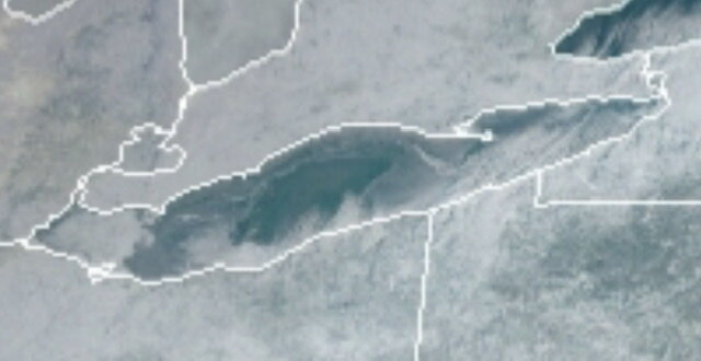
-
GFS says what thaw? Wow check out hour 240+ Could be Lake Erie last hoorah with a lake effect blizzard!
-
Hmmm the best looking band so far is over the frozen half of the lake… got it! Also a nice area of snow developing to our NW along the front itself. We could possibly burst our way to 2” overnight. BW what’s that site you have that shows the whole Great Lakes at once?
-
Well this event wasn’t really even picked up by the models… -1 for the humans on this one… but I’m still holding out. Might be aggressive for So Erie with that 6”+ zone but it’s early boys.
-
Leaving the window open for an overachiever I guess… chances for snow ramp up near the lakes due to sw low-level flow, convergence ahead of the front and sufficiently cold air for a lake response. Majority of moisture is below 10kft but lift in that layer is decent as seen by low-level omega toward northeast end of both lakes. Since the arctic front does not arrive until after 09z east of Lake Erie and toward 12z or even afterward east and southeast of Lake Ontario, low-level flow does not veer too quickly, allowing sw-w flow to stay locked in place. Though not many models show it outright, did increase QPF/snow some to east of Lake Erie especially into Southern Erie and over western Chautauqua county given potential that stronger band forming this evening into Metro Buffalo could stall out for a while over these areas.
-
Not much residence time on that band as it slides north but picked up another 1.5” here as it rolled through. Been quite the stretch. Feels like every 12 hours or so we just get a fresh dusting of snow to keep up the good looks!
-
Looking pretty good actually…
-
this Lake Ontario band has been incredible to watch. Looks like it’s going to spin up into a bigger more defined swirl as it gets pushed north
-
Yikes…
-
ARW picked this band up very well… just had the accumulation to far inland. Should be fun to watch as day progresses… It spins the Ontario band up and then tea kettles some fluff along the Lake Erie shoreline later this afternoon as flow turns to WSW.
-
Almost looks like the head of the Ontario band is getting sheared and pushed south. Few lighter returns floated over Ontario and then perked back up over Erie. Came down to do a scouting report on the ice but can’t see that far out.
-
Down at the harbor and it’s rippin!
-
That’s a big storm…
-
0, 36, 72 hour ice forecast has a pretty rapid buildup this week. That central area off Long Point is still 35-38 degrees and will hold a while longer.
-
Doesn’t look like much but a little lake plume trying to develop behind the main feature.
-
Sunrise was awesome this morning. Phone camera sucks but those colors!
-
Upstate NY Banter and General Discussion..
SouthBuffaloSteve replied to wolfie09's topic in Upstate New York/Pennsylvania
im just saying... we played the chiefs 2 out of our 4 post season super bowl runs. Allen Mahomes will be a battle through 2030 in the AFC. -
Upstate NY Banter and General Discussion..
SouthBuffaloSteve replied to wolfie09's topic in Upstate New York/Pennsylvania
Those last two minutes were like a madden game set on arcade mode with rookie difficulty... I just still cant comprehend how we lost the game... 3 different times? just a dagger tonight... sucks the trip is over but at least we have a winning team to keep building around. Allen Mahomes is going to be like??? Kelly Marino? That was the top 8 QB rivalry from an NFLcom article, #1 was Brady and Manning... Allen Mahomes could challenge that this next decade! -
Upstate NY Banter and General Discussion..
SouthBuffaloSteve replied to wolfie09's topic in Upstate New York/Pennsylvania
I like this idea! -
Upstate NY Banter and General Discussion..
SouthBuffaloSteve replied to wolfie09's topic in Upstate New York/Pennsylvania
Can tell you’ve never been to a bills game… don’t worry they ain’t our cousins like down in tenny-c -
Upstate NY Banter and General Discussion..
SouthBuffaloSteve replied to wolfie09's topic in Upstate New York/Pennsylvania
Heard a few analysts say this game could have been the super bowl match up as they were the only 2 real teams this year. KC will destroy Cinncy and whoever comes from the NFC. -
Upstate NY Banter and General Discussion..
SouthBuffaloSteve replied to wolfie09's topic in Upstate New York/Pennsylvania
I hope the books closed the live line down early… my god.. -
Upstate NY Banter and General Discussion..
SouthBuffaloSteve replied to wolfie09's topic in Upstate New York/Pennsylvania
Watching the post game shows everyone is saying this was probably one of the best playoff games you will ever watch. Bills put up a hell of a fight. I know it’s cliche… but next year mafia!


