SouthBuffaloSteve
-
Posts
2,617 -
Joined
-
Last visited
Content Type
Profiles
Blogs
Forums
American Weather
Media Demo
Store
Gallery
Everything posted by SouthBuffaloSteve
-
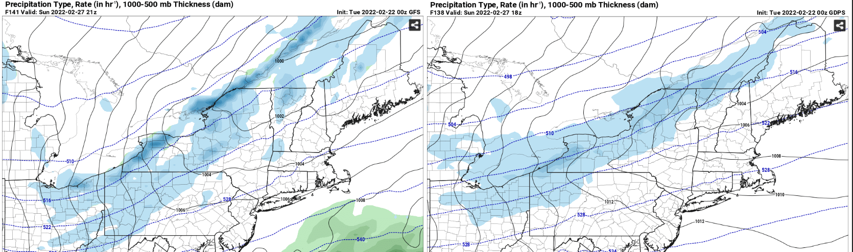
 Both in good agreement of a decent snow squall rolling across upstate NY early Sunday afternoon. GFS already trying to show a pretty solid band... If this does trend to be the forecast this will be a must chase. Snow squall screaming across the lake with daylight this time.
-
Nice video! The first 60 seconds what kind of speed were you maintaining? Looks like you were still coasting along at 30 maybe? Right at the 60 second mark that vehicle just appears so fast out of the snow. Driving on 81?
-
looks like we could have the potential for another snow squall line developing as well if this solution were to verify. This time period does look interesting to watch.
-
Upstate NY Banter and General Discussion..
SouthBuffaloSteve replied to wolfie09's topic in Upstate New York/Pennsylvania
Fact. That was the premises behind the 1995 US invasion of Canada. Following a hockey brawl over some bad beer, Niagara County Sheriff Bud Boomer lead a crack special forces unit across the River for a night time trash dumping raid on the Niagara Regional Park. Bad recon by Deputy Roy Boy ultimately lead to the Royal Mounties discovering the Americans. A small skirmish broke out forcing Boomer and team to retreat. However in their hurry Deputy Honey was left behind and captured by Canadian forces. Boomer rallied hundreds of Western New Yorkers to take up arms against the Canadians and lead a second invasion a few days later to rescue Deputy Honey. The Feds in Washington felt upset they were not involved in planning this raid and thus started a tense 3 day nuclear standoff with the Canadians. Boomer’s team ended up being victorious and not only rescued Deputy Honey but also destroyed the Canadians first strike nuclear capabilities in the CN Tower. Due to the poor handling of this incident by literally everyone it was virtually erased from the history books. If your under 25 you probably have never even heard the story of the Great Canadian Bacon War. -
BW driving up 81 right now like… lol… couldn’t have timed that any better.
-
One more video from this morning. Kinda wish I would have went out on foot… but the car was so nice and warm!
-
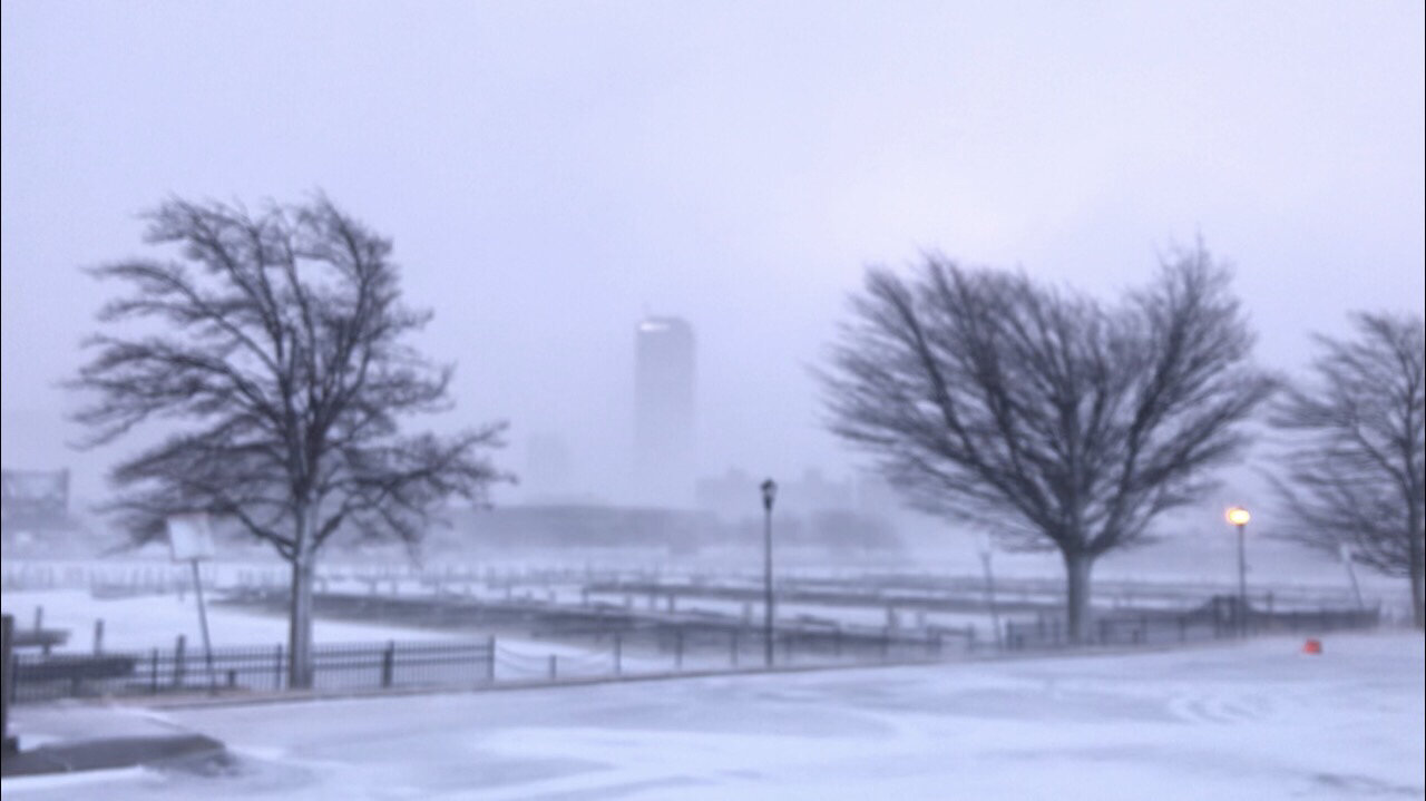
Wow! Check out this shot from Ontario after the line passed and the blue skies came out. Insane clouds and can see the snow blowing off the ice sheet.
-
Video didn’t do it any justice. That was one of the most intense snow bursts I have ever been through. From just how fast it went from flurries to whiteout. The intense winds within the line shaking my vehicle. The thunder and lightning.
-
Or they didn’t want to light up everyone’s phone with a snow squall warning early on a Saturday morning?
-
Thunder was really muted with the wind but got a nice flash right over the Buffalo skyline..
-
Yeah they really should have issued a warning for Buffalo area. I was down there waiting to intercept it and it caught me off guard, only image people out driving unaware.
-
Winds were strong pre front 40-45 but really ramped up inside the squall line. Car was violently shaking for a few minutes had to be 55-60 gusts. Crazy how fast the winds subsided to just a breeze on the backside of the front. Got at least 4 thundersnow strikes.
-
It just hit so fast. Barely made it back into the car just saw a wall of white racing towards shore and bam went from clear to whiteout in 10 seconds. Snagged 2 super bright thundersnow flashes in the whiteout.
-
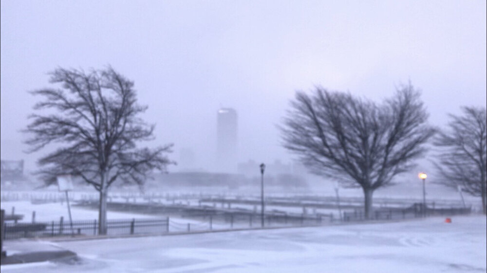
Insanity down here!
-
Was a little late getting out. Made for a very fun drive downtown this morning. Winds are really whipping the snow around… Hunkering down at the Erie Basin Marina for the front passage.
-
Still this has been an interesting little system. Was well shown on models but it’s really spinning up out of almost no where and then goes poof as quick as it appeared. Guess it’s just letting the cold air do all the work. Not asking for 100mph winds but how about a few claps of thundersnow. These pulsing squall lines along the front have some power behind them.
-
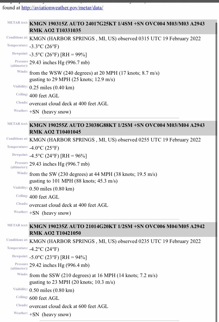
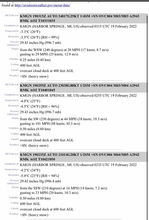
This is an official airport ASOS site in Harbor Springs Michigan with meter data. Read the middle observation!
-
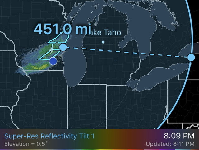
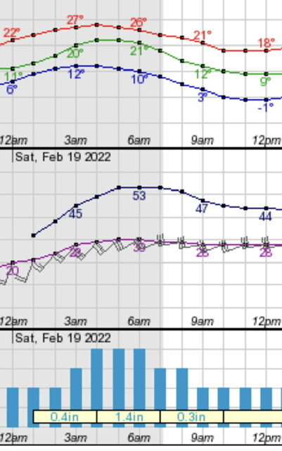
Was going to ask your thoughts on timing. Based on radar still looking like the front itself is 10 hours out (45 mph… 450 miles) so 6am ish. Feel the highest winds will only be a 3-4 hour window thinking 4am-8am with the peak period being 6am-7am when the front comes though. Winds have been brisk off Erie this evening already gusting over 30.
-
Northern Erie-Chautauqua-Southern Erie- 230 PM EST Fri Feb 18 2022 ...LAKESHORE FLOOD WATCH IN EFFECT FROM 1 AM EST SATURDAY THROUGH SATURDAY MORNING... * WHAT...Significant lakeshore flooding possible along with the potential for ice shoves. * WHERE...Erie and Chautauqua counties. * WHEN...From 1 AM EST Saturday through Saturday morning. * IMPACTS...Despite the presence of ice floes on eastern Lake Erie, strong southwest winds are expected to shift ice around which could lead to erratic water level rises at the eastern end of Lake Erie. There is a potential of localized ice shoves as well. In addition, shoreline areas free of ice could experience lakeshore flooding. This includes along Route 5 in Hamburg, Buffalo Harbor and Canalside, Dunkirk Harbor, and other flood prone locations. Very high wave action where little shoreline ice is present may also result in significant shoreline erosion.
-
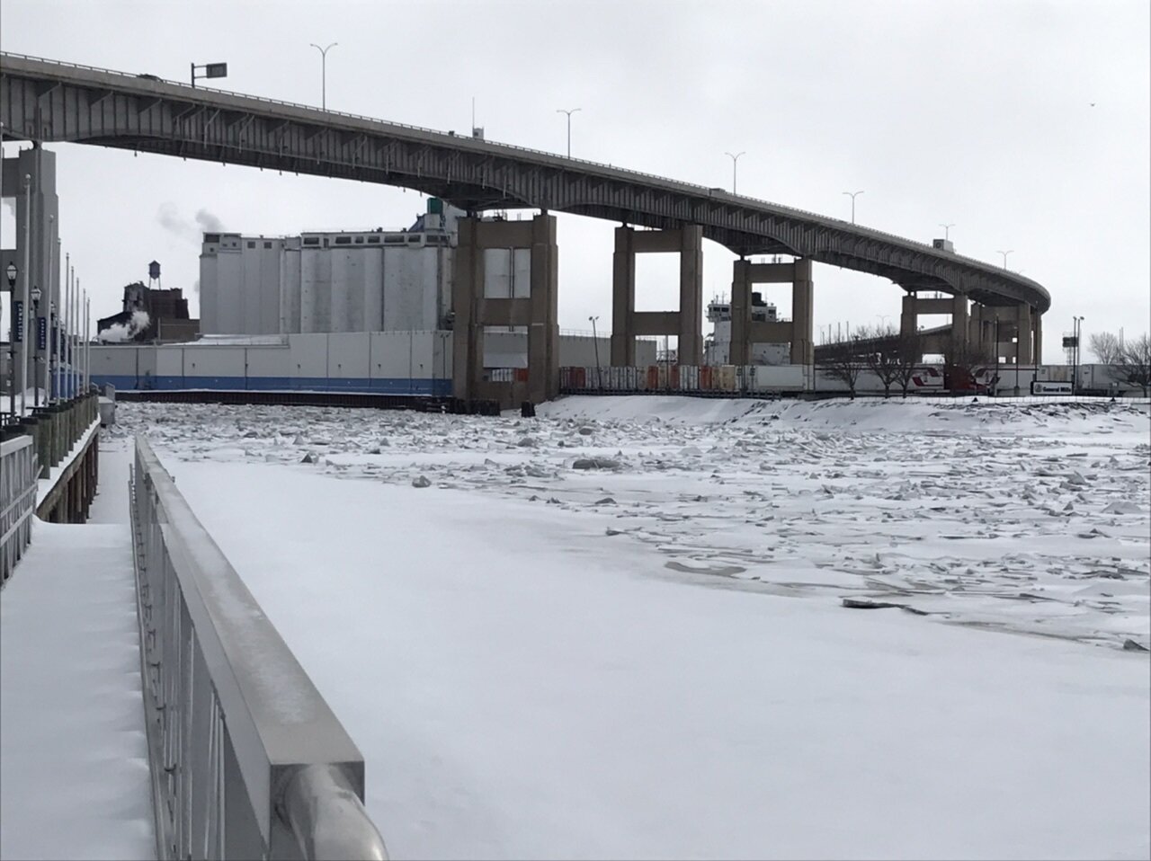
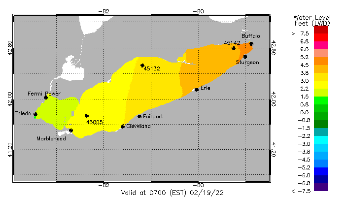
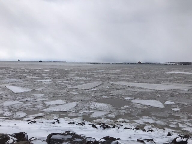
Yeah I’m not expecting the River Ice to go anywhere. I’m going down to see the Lake ice once the Seiche rises to around 4-5’ the lake level will be above the booms max height causing it to submerge and then the ice will get pushed over top of it and start to rapidly fill into the Niagara River.
-
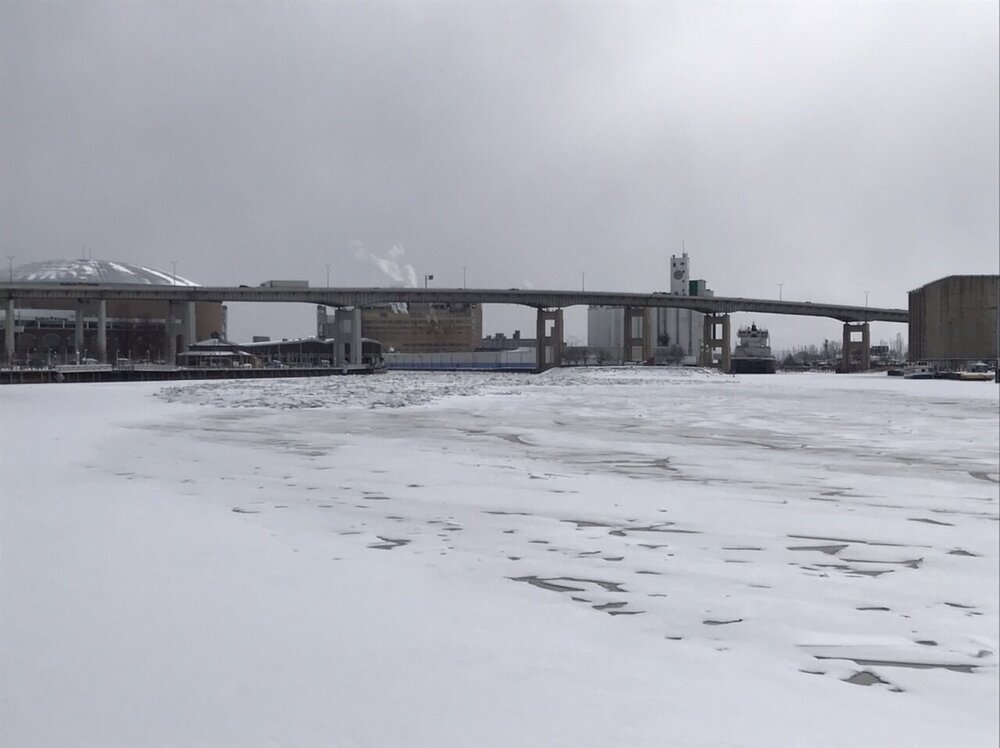
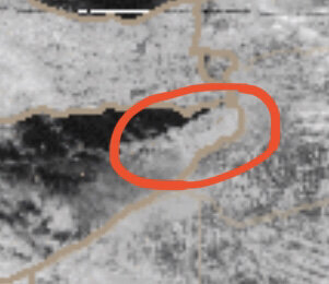
The River ice flow came to an abrupt stop about 500 yards from the lake. Rather interesting it couldn’t make that final push out considering the lake channel was ice free. There is now a jam frozen in place from the mouth of the River all the way back to the South Park lift bridge.


-
Thinking maybe 5-6am as that looks to be peak winds and so I can be at my spot before the squall rolls in. Planning to setup at Erie Basin Marina (as long as the city doesn’t close the parkway). Little shore ice but then open water until you hit the boom. Just need to make sure the timing on this doesn’t move up sooner again.
-
Nice pile in the NE end. Be interesting to see if the winds will be strong enough tomorrow to wreak any havoc. Gonna be an early rise to chase this one.
-
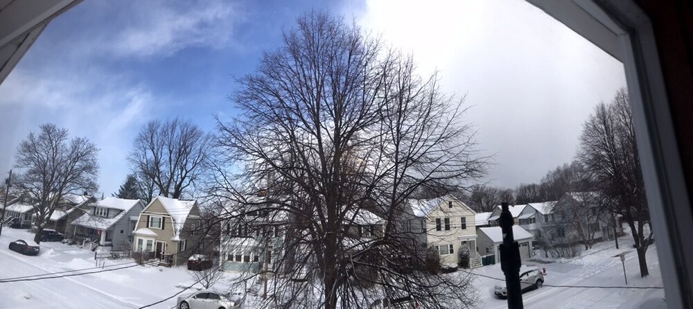
Def some nice streamers this morning. Had some blue skies and bright sun but looks like another snow burst heading in.
-
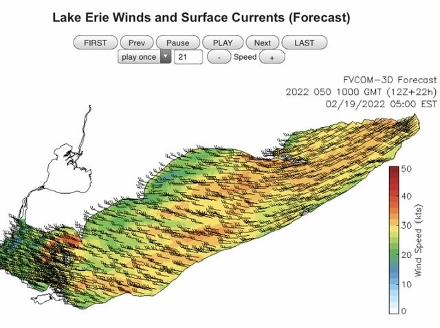
Yeah has a nice look. Planning to setup for a few hours tomorrow morning either along the lake or Niagara River. Looks like a nasty squall line could roll through to start and then a couple hour window of 50+mph gusts. Not sure if it’ll be enough to create an “ice tsunami” but only one way to find out!