sbnwx85
-
Posts
1,928 -
Joined
-
Last visited
Content Type
Profiles
Blogs
Forums
American Weather
Media Demo
Store
Gallery
Everything posted by sbnwx85
-

Nov 28-30th Post Turkey Day Winter Storm
sbnwx85 replied to Chicago Storm's topic in Lakes/Ohio Valley
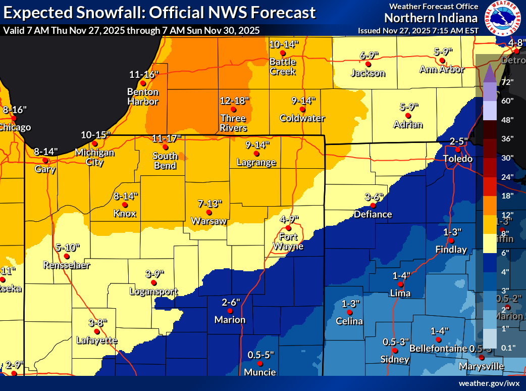
Potential for two top 10 November snowfalls in the same year in South Bend. Maximum 2-Day Total Snowfall for SOUTH BEND AP, IN Click column heading to sort ascending, click again to sort descending. Period of record: 1893-12-01 to 2025-11-26 1 20.5 1977-11-26 0 2 18.0 1911-11-03 1 - 18.0 1911-11-02 1 4 14.6 1977-11-25 0 5 14.3 2025-11-10 0 6 13.6 1951-11-07 0 7 13.5 1930-11-27 0 8 13.4 2014-11-14 0 9 13.0 1930-11-26 0 10 12.3 2014-11-13 0 -
Nov 28-30th Post Turkey Day Winter Storm
sbnwx85 replied to Chicago Storm's topic in Lakes/Ohio Valley
If IND can pull their WSW all the way south to Indy, DTX can cover their CWA with a warning, too. -
Nov 28-30th Post Turkey Day Winter Storm
sbnwx85 replied to Chicago Storm's topic in Lakes/Ohio Valley
WSW up. I never dreamed November would produce another big dog this year after the 10" lake-effect event three weeks ago, but here it is. Some areas to my immediate northeast will have 18" on the ground thanks to last night's lake event. -
Classic lake-effect event here overnight. Half-inch at my house. Within a mile of work, it started snowing, roads are a mess, and there's 2" of snow on the ground. Some areas just over the state line in Michigan picked up 6".
-
Nov 28-30th Post Turkey Day Winter Storm
sbnwx85 replied to Chicago Storm's topic in Lakes/Ohio Valley
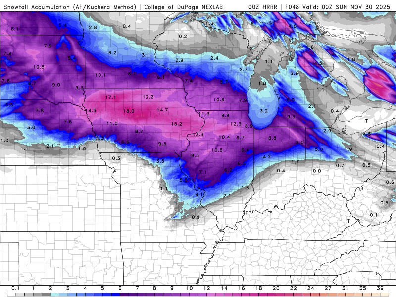
HRRR/RAP dry slot me but put down 11” of snow before that happens. That’s probably overdone. Final call: 9” -
Nov 28-30th Post Turkey Day Winter Storm
sbnwx85 replied to Chicago Storm's topic in Lakes/Ohio Valley
Last hour of the HRRR plus kuchera amounts. It’s making me a little nervous seeing how far north that warm air is budging in… and a potential dry slot.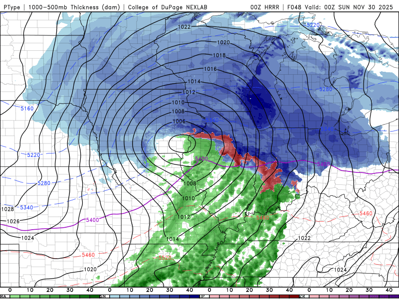
-
Light snow most of the day but DAB-. Roads are clear. Still a festive-looking day that felt more like Christmas than Thanksgiving.
-
Nov 28-30th Post Turkey Day Winter Storm
sbnwx85 replied to Chicago Storm's topic in Lakes/Ohio Valley
Could cash in on lake effect bonus Sunday. 12”+ in play. -
Nov 28-30th Post Turkey Day Winter Storm
sbnwx85 replied to Chicago Storm's topic in Lakes/Ohio Valley
The high end of the range is way overdone. 11” here by Sunday morning is plausible if things go well. For the storm itself, things have been looking good for 6-10” for a while. NAM is juiced up but that’s typical at this point. -
Nov 28-30th Post Turkey Day Winter Storm
sbnwx85 replied to Chicago Storm's topic in Lakes/Ohio Valley
This includes today’s lake effect but c’mon now.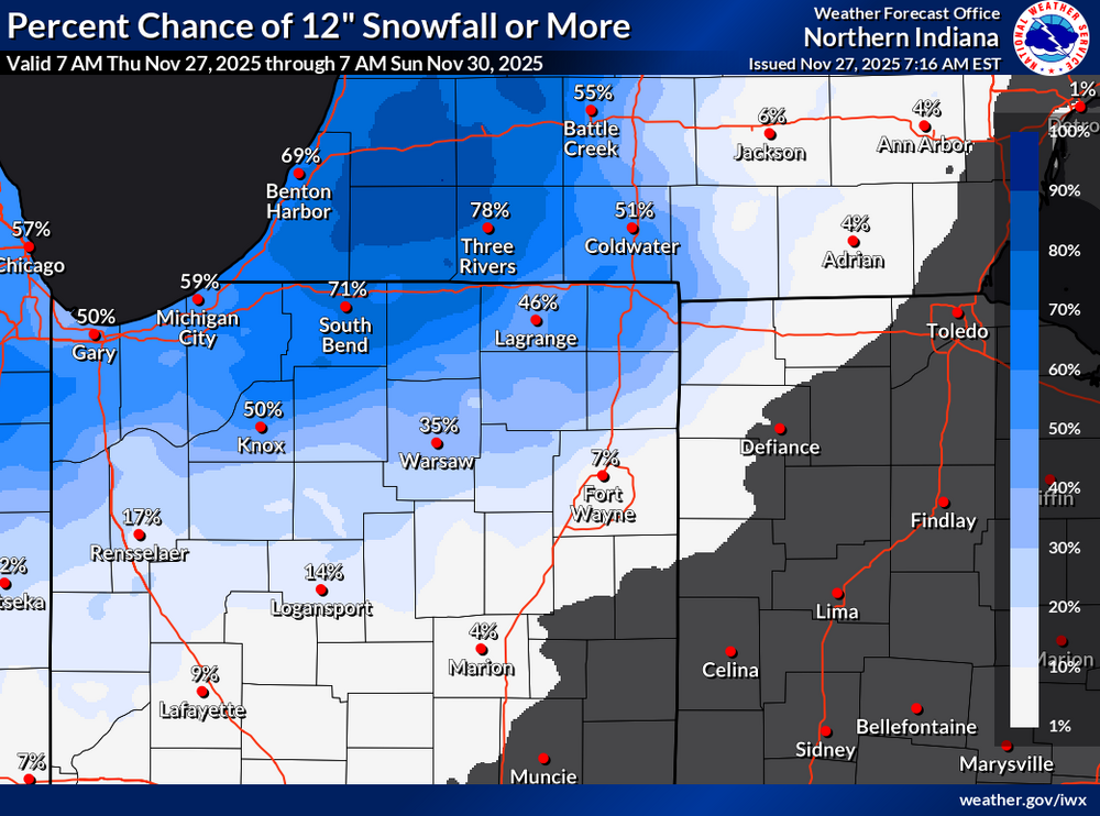

-
Power is back. Thanksgiving is still on... for better or worse.
-
Nov 28-30th Post Turkey Day Winter Storm
sbnwx85 replied to Chicago Storm's topic in Lakes/Ohio Valley
This is it. 6-8", especially in November, is a big win. Hopefully sets the tone of the rest of the winter! -
Nov 28-30th Post Turkey Day Winter Storm
sbnwx85 replied to Chicago Storm's topic in Lakes/Ohio Valley
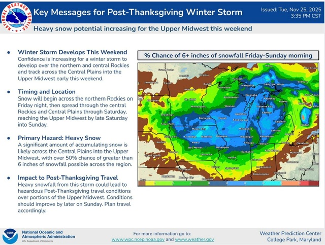
Just sharing because it shows the NWS Blend of models -
Nov 28-30th Post Turkey Day Winter Storm
sbnwx85 replied to Chicago Storm's topic in Lakes/Ohio Valley
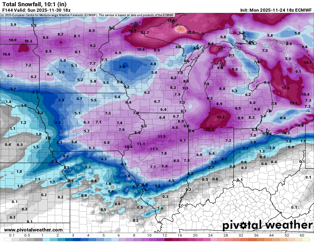
Even the 10:1 map is a big dog. -
Nov 28-30th Post Turkey Day Winter Storm
sbnwx85 replied to Chicago Storm's topic in Lakes/Ohio Valley
GFS continues to improve. I think many of us would take this in a heartbeat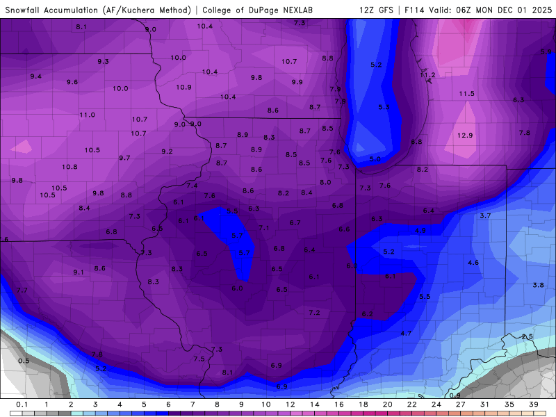
-
Just lost power because of 45-50 mph gusts. We were supposed to host Thanksgiving. Hopefully the power comes back on by morning.
-
Nov 28-30th Post Turkey Day Winter Storm
sbnwx85 replied to Chicago Storm's topic in Lakes/Ohio Valley
Euro nudged south. We are right back in this ballgame. -
Nov 28-30th Post Turkey Day Winter Storm
sbnwx85 replied to Chicago Storm's topic in Lakes/Ohio Valley
-
Nov 28-30th Post Turkey Day Winter Storm
sbnwx85 replied to Chicago Storm's topic in Lakes/Ohio Valley
Different ways of getting there but GFS and Euro manage to drop 5” of slop on those runs. -
Nov 28-30th Post Turkey Day Winter Storm
sbnwx85 replied to Chicago Storm's topic in Lakes/Ohio Valley
Need the north trend to stop for sure. Half of what falls on the euro imby is lake effect and it’s overdoing that big time. -
Nov 28-30th Post Turkey Day Winter Storm
sbnwx85 replied to Chicago Storm's topic in Lakes/Ohio Valley
UKIE stayed south FWIW. Is the Canadian delayed? -
Nov 28-30th Post Turkey Day Winter Storm
sbnwx85 replied to Chicago Storm's topic in Lakes/Ohio Valley
6z Euro held serve and the 6z GFS was another step in the right direction. Warm air nudging in too far north is definitely a concern moving forward, but so far, so good. -
Nov 28-30th Post Turkey Day Winter Storm
sbnwx85 replied to Chicago Storm's topic in Lakes/Ohio Valley
GFS is a step in the right direction. -
Nov 28-30th Post Turkey Day Winter Storm
sbnwx85 replied to Chicago Storm's topic in Lakes/Ohio Valley
Yea, I was thinking that based solely on climo, the rain/snow line ends up much further north than currently forecast. Not a bad look, though, for late November. As you say, hopefully a sign of good things to come. -
Nov 28-30th Post Turkey Day Winter Storm
sbnwx85 replied to Chicago Storm's topic in Lakes/Ohio Valley
18z Euro a little further north again. Totals around N. IN and SW. MI includes the lake effect from Thursday.