Eskimo Joe
-
Posts
24,733 -
Joined
-
Last visited
Content Type
Profiles
Blogs
Forums
American Weather
Media Demo
Store
Gallery
Everything posted by Eskimo Joe
-
Euro seems to be the best case scenario right now. Low end warning snow/sleet then dry for I-95 immediate suburbs, big storm US 15 west. EDIT: Give it a 50 mile east shift and everybody wind bigly.
-
Pretty decent lift with the WAA snow and along the backside, I-81 and points west probably get slammed from this. If only we can get this like 50 - 60 miles east.
-
If we can get 6" - 10" with no rain, it'll be a win. Sleet/ZR, that's fine. Just don't want to wash the snow away.
-
I don't care if I mix, I just don't want to spike to rain and 50 degrees.
-
Yea that's terrible. Screaming SE winds will wash out any low level cold. Total disaster.
-
Randy should've known better than to start a thread for a D6 event in a La Nina year.
-
Welcome. 100% agree with you.
-
Down to 17 degrees with clear skies and no wind.
-
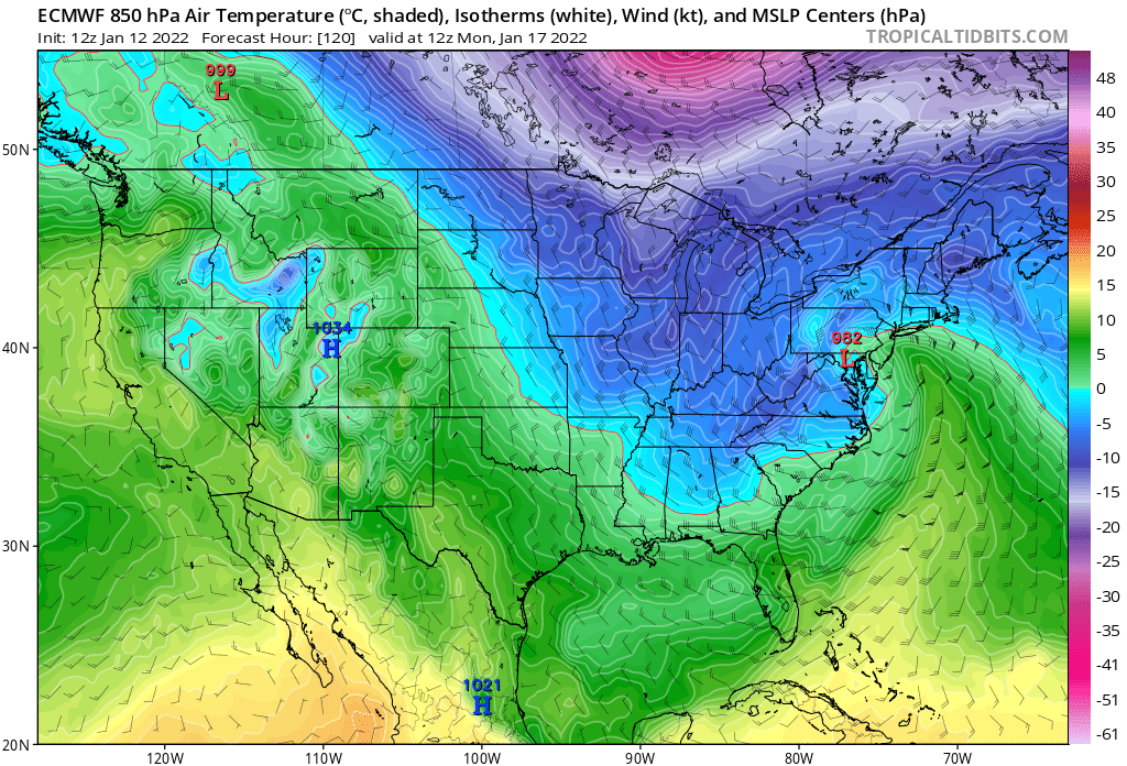
The position and strength of the Canadian high is much better on the op run of the 18z Euro than the GFS.
-
Really appreciate the insight here from you and the rest of the Mets. The discourse over the past several pages has been quite informative.
-
There are verification scores for each model going out to D6.
-
18z GEFS loses almost all of the inland lows. Really hope Crack. GFS and Euro runs are just too wound up and smoking crack.
-
I know this is kind of a weenie sentiment, but I'd like to give this another 24 hours before we kill this. Couple of things I'm looking for: 1.) Do we see this west trend continue? 2.) Would like to see what happens once we get this system onshore an into the North American upper air network. 3.) Hopefully we can get the antecedent high into a better position. We need it over Quebec, not New England, to lock in the cold and prevent the coastal from running inland.
-
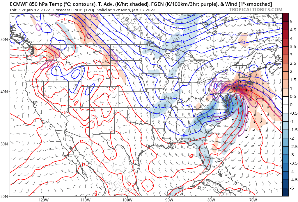
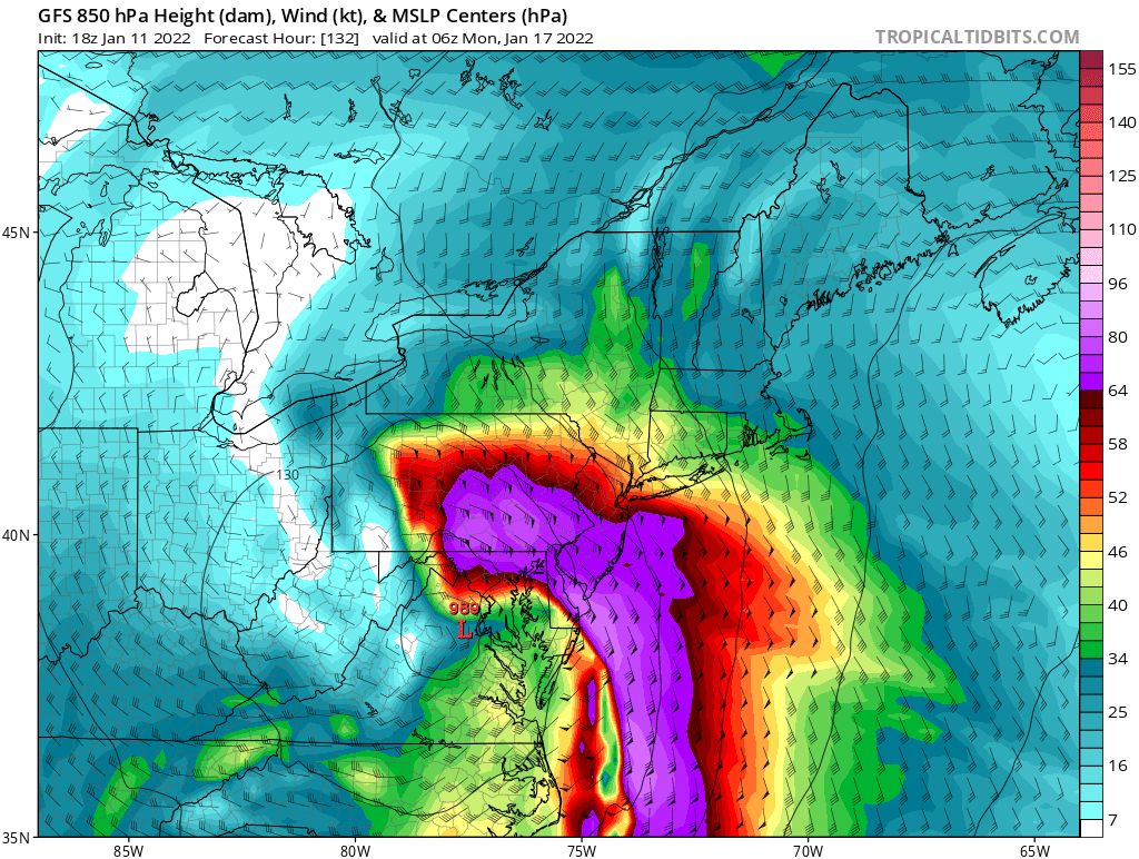
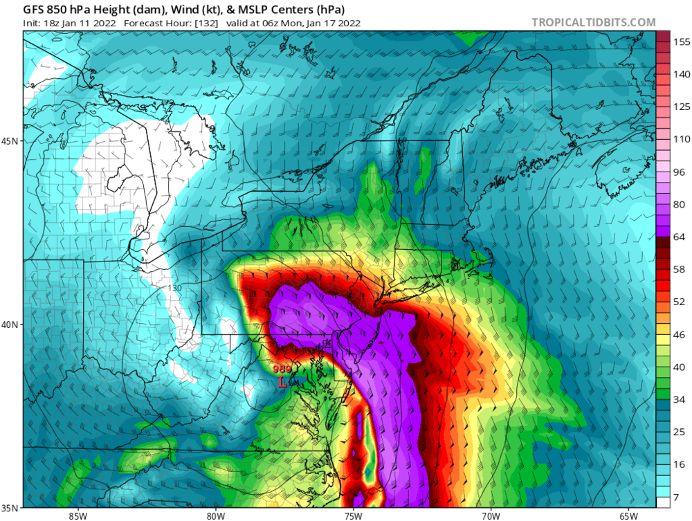
GFS with an insane jet at 850. Winds screaming off the ocean like that will warm you up quick no matter what.
-
Yea its an ugly op run. No other way to slice it.
-
Antecedent high too far east. We need it over Quebec, not Vermont.
-
18z OP GFS is a disaster. Hope the ensembles are different. System just winds up too fast.
-
Personally, I'm more focused in the evolution at 500/850 and the ensemble mean versus operational. Beyond HR96, you'll just drive yourself crazy focusing on run to run variations of the operational side of things.
-
-
Man, that's a sizeable number of big hits on the 12z EPS.
-
Good point @brooklynwx99 how often do you see a closed 500mb low on ensemble guidance at D5/6?
-
As long as I stay all frozen through the event I don't care. If that means ZR and IP that's fine. Just a stouter snowpack to keep the cold in.