StormchaserChuck!
-
Posts
2,274 -
Joined
-
Last visited
Content Type
Profiles
Blogs
Forums
American Weather
Media Demo
Store
Gallery
Everything posted by StormchaserChuck!
-
A year ago 3 weeks ago https://ibb.co/ZHMtL1C
-
High global ace
-

2021-2022 ENSO
StormchaserChuck! replied to StormchaserChuck!'s topic in Weather Forecasting and Discussion
https://en.wikipedia.org/wiki/Accumulated_cyclone_energy Nino 3.4 (both hemisphere's) and NAO correlation, whole year 20-year period of +ACE, -ACE and Neutral dataset high ACE https://ibb.co/8sXkRmG low ACE https://ibb.co/j4WnbzY Neutral https://ibb.co/xjNrBR4 -
2021-2022 ENSO
StormchaserChuck! replied to StormchaserChuck!'s topic in Weather Forecasting and Discussion
Pretty much the end of this La Nina, this is going to propagate east, and that's going to be the end, warming into the Spring. Surface may still cool, but the subsurface won't cool west of this anymore. Also, no consistency. March-May is Neutral. (these guys have frozen my page 8 diffeernt times, before I can press send and stuff I hate that) -
So if the Super '15 El Nino started in the West, US (drought), I wonder if we are going to have west to east effects this round (round 2)
-
I have to wonder about the curse of Boston 3" a couple Winter's ago, and that fields have flattened a little since then. I think there is a little I-95 perception/magnet.
-
I think we are due for a Tropical Storm hit sometime in the future. 30 storms last year, and 30+ probably this year, and we are like 1:3 behind in the decadal averages. check out this -NAO coming for D4 https://ibb.co/476WdDh
-
Historical New York weather data with 1s frequency
StormchaserChuck! replied to Pszemo's topic in New York City Metro
You should be able to find it. You can always e-mail NWS. -
2021 Atlantic Hurricane season
StormchaserChuck! replied to StormchaserChuck!'s topic in Tropical Headquarters
The two red's are probably fish storms Irma and Georges https://ibb.co/yFXtWv0 https://ibb.co/W08P9sZ We need realy a trough over NE US or New Foundland/NorthAtlantic area.. we have opposite https://ibb.co/V34wMDF -
Nice -NAO https://ibb.co/RhbHT17
-
2021-2022 ENSO
StormchaserChuck! replied to StormchaserChuck!'s topic in Weather Forecasting and Discussion
Although it was El Nino the PDO was a greater SD before the 2015 El Nino.. https://ibb.co/VQtRhc6 and then when the super El Nino started, it actually started to wane/shift -PDO a little https://ibb.co/ZXBZ3sr -
2021-2022 ENSO
StormchaserChuck! replied to StormchaserChuck!'s topic in Weather Forecasting and Discussion
I'm out of upload space. This is the Winter's of the 1940s, before satilite. 8 Winter's. ^Jan-Mar 1948,49,50,51
-
2021-2022 ENSO
StormchaserChuck! replied to StormchaserChuck!'s topic in Weather Forecasting and Discussion
I guess the data goes downhill from 2013on. I also noticed when satellite data started in 1948, before then there was more +PDO,by like a 1.0 difference. There was another PDO dataset which is no longer listed. -
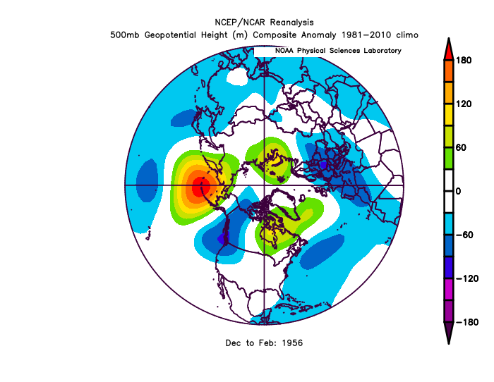
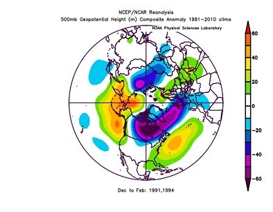
1955-56 had a nice -PDO (opp) 90-91 and 93-94 had nice -opposite PDO [url=https://imgbb.com/][img]https://i.ibb.co/GFgDmFs/8.png[/img][/url]
-
Yeah, it was also suppose to break below 1.40 first (technical signals), wonder what it means.
-
The last few Christmas' have been -NAO.
-
2018 kind of blew that away.
-
I wouldn't be surprised if it warms up early Next Spring, we also started getting this Nino1.2 vs Nino 4 thing going in 2000.
-
PDO analogs
-
2021-2022 ENSO
StormchaserChuck! replied to StormchaserChuck!'s topic in Weather Forecasting and Discussion
We're going to get a real strong -PDO this Winter. Analogs 2020-21 -PDO 2019-20 -PDO 2014-15 +PDO*preceded 4months rise of 2015 El Nino. 2012-13 -PDO 2011-12 Strong -PDO, almost -3 in Nov 2011 2010-11 -PDO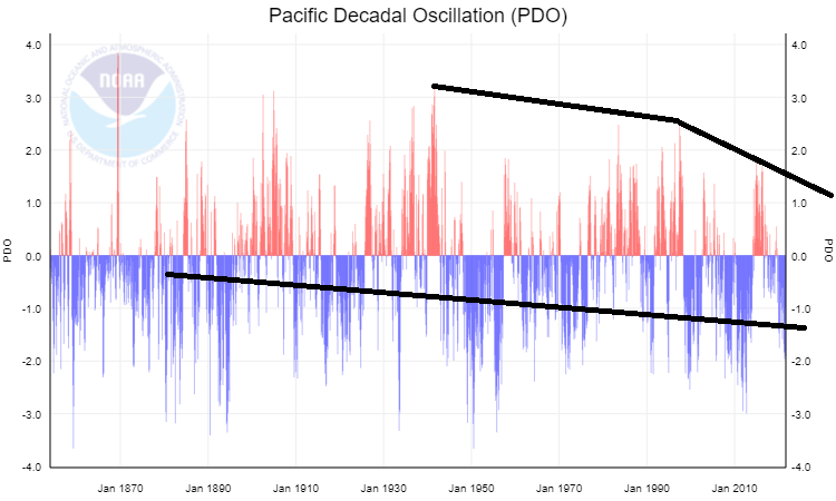
-
2021-2022 ENSO
StormchaserChuck! replied to StormchaserChuck!'s topic in Weather Forecasting and Discussion
-
Hot spot though https://en.wikipedia.org/wiki/2017_Atlantic_hurricane_season#/media/File:2017_Atlantic_hurricane_season_summary_map.png
-
2021 Atlantic Hurricane season
StormchaserChuck! replied to StormchaserChuck!'s topic in Tropical Headquarters
Remember this Cat 5 in 2019 https://en.wikipedia.org/wiki/2019_Atlantic_hurricane_season#/media/File:Lorenzo_2019_track.png -
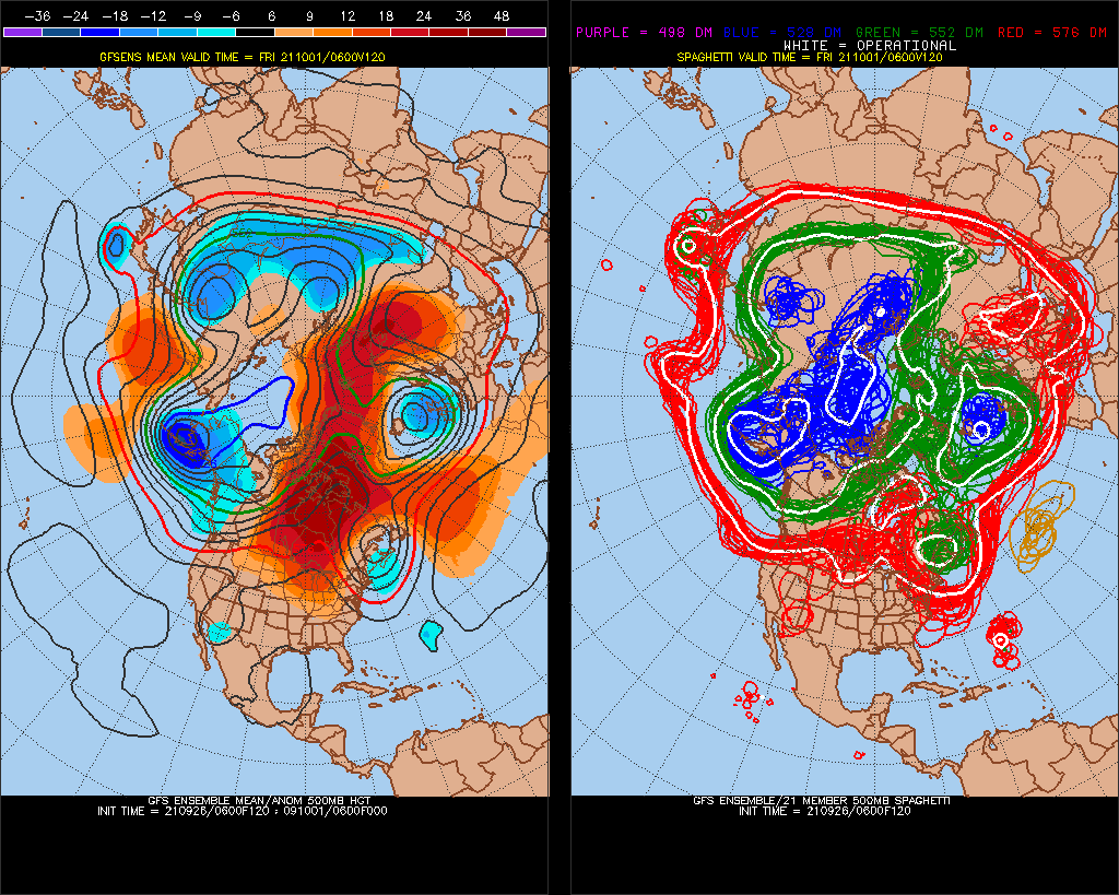
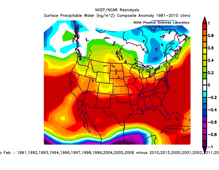
I think this Aleutian ridge is just feeding off of SSTs (384hr) Should be interesting to see what happens.. I think there is not much correlation
.thumb.gif.c8cf0dd258c5013a7c4b129c1debac13.gif)
-
Slowly creeping up has been this -NAO at the turn of the month here Analogs


.gif.50ed53cbddabd9594759e4e23c8dbee6.gif)