

Itstrainingtime
-
Posts
16,416 -
Joined
-
Last visited
Content Type
Profiles
Blogs
Forums
American Weather
Media Demo
Store
Gallery
Posts posted by Itstrainingtime
-
-
3 minutes ago, MAG5035 said:
A new day dawns to the first accumulation of snow on the ground in over a month (coating)... 12 hours after having thunderstorms roll through.
Good for you! I was a little surprised when I woke up and it was still 41 degrees down this way. Thought it would be colder, but I'm guessing with a pretty good NW breeze today we'll see nearly steady temps before falling this evening.
-
3 hours ago, Blizzard of 93 said:
It’s game time !
Who’s going to start our thread for this weekend event ?
The 0z Euro, EPS & GEFS all agree that CTP will be getting snow this weekend! It looks like a long duration light to moderate snow event at this time.
Yep...that's the type of snow that's been largely missing for quite a few years down this way. A good 'ole 2"-4", 3"-6" snowfall. If it materializes, we take.
-
 1
1
-
-
13 minutes ago, canderson said:
Euro looks to get 2" or so inches up to MDT for Sunday. It's still a Virginia special mostly it appears.
Horst PM update: (Blizz isn't going to like it :()
WED/THU will be windy & seasonably cold, before a brief Arctic blast arrives FRI/SAT...likely both sub-freezing days. A southern storm will threaten SAT PM into SUN...with Lanco on the northern edge Still too early to call...but some accumulation is possible.
-
Sleet and 31 here.
-
51 minutes ago, bubbler86 said:
I thought liberty somehow, even with many days in the 50's, had some slopes open...not the tubing though last time I checked. It has indeed been a terrible season for them so far.
They opened on 12/23 but closed down a week or so ago.
-
Given the forecast for the rest of the week starting Wednesday, probably the happiest people around these parts operate RoundtopMtn resort. Boy what an awful start of their season so far. Liberty Mountain isn't even open.
-
2 minutes ago, daxx said:
Euro is very weak. We might get a coating out of it. Still have time.
It'd be disappointing to miss this one, at the same time it's kind of a bonus opportunity before the real meat of the pattern change occurs anyway.
-
8 minutes ago, pawatch said:
GFS looking better...Going to be a long week. A lot is going to depend on the timing of the southern stream
I was getting pretty excited until I saw the Ukie. We need the good doctor to deliver a big emphatic "YES" in 30 minutes...
-
1
-
-
50 minutes ago, TugHillMatt said:
That is my exact memory of snow totals from that wonderful week. I remember listening to the radio as my mom and I left our house in Willow Street to go grocery shopping at John Herr's in Millersville. During the drive, they announced increasing snow totals. It was a beautiful sunny Saturday morning...before a beautiful snowy week!
That's where we shopped when I was growing up!
")
I would love a repeat of '96...or '83...or '78. Or a whole bunch of storms from the past 15 years or so. Hopefully this upcoming pattern delivers in a big way. Tired of mud and high water, that's for sure.
-
1
-
-
3 minutes ago, sauss06 said:
My annual reminder in case you fellas forgot this storm! Best birthday gift of all time!

If I remember correctly, every (or almost) computer model had that storm sliding off well to our south until the last 36-48 hours before game time. Paul Knight was on Weather World during the week preceding the storm (it hit on a Sunday) and it was on Wednesday's show that he went against all models and other mets and called for a flush hit. And at least for the southeastern 2/3 of the Commonwealth, flush hit it was. It was one of the great classic storms where the initial forecast was for 3"-6", which was the call late Friday night. Saturday morning it went up to 6"-12". Saturday night it was 12"+, and by Sunday morning it was something like 20"-30". It was super cold too...woke up to moderate snow first thing Sunday morning with an air temperature of 10.
Ended up with 30". Got 2" more on Tuesday and then 10" more on Friday. 42" that week was the most weekly snow I ever saw until 2/5 - 2/10/2010 when I got 44".
-
3
-
-
25 minutes ago, bubbler86 said:
I was just coming on to post about the WWA. Would be surprised to see too many icing issues with the warm temps lately but still interesting.
Everyone keeps saying the 13th and 14th for the weekend storm...GFS would have snow moving in during Saturday the 12th.
Interesting modeling war as the Euro wants no part of this save for coastal Delmarva.
-
 1
1
-
-
16 minutes ago, Blizzard of 93 said:
GFS FV-3 for the win next weekend!

That would be a cold powdery snow too. My favorite kind of snowstorm. Bring 'er home!
-
3
-
-
Horst mentioning a 4-5 day transition to colder weather with an "outside chance of snow on January 13th."
-
You know it's been a bad winter to date when you walk outside and it feels really cold...and then you realize it's 46 degrees.
-
1 hour ago, Blizzard of 93 said:
Yes, that’s true! ( I see what you did there & that was nicely done good sir...)
I also hope that we can have at least a week or 2 in January for a few bouts of wintry weather as well !
This place should be getting busy soon!
You know I posted that primarily with you in mind.
Thanks for the compliment!
-
14 minutes ago, pasnownut said:
Hey man. Keep your eye out at next Sunday. I posted in the other thread yesterday that I was liking the trends for that period and today seems to be showing more signs of potential. Like Bob suggested, it’s early in the flip but I feel that guidance is still in catch up mode and that’s why I think it’s worth watching. NS is better but lose that shortwave that shows on the GFS and it may be legit. If you like the GEM and digital snow...go take a peek.
Oh I've been reading every post in that thread, trust me.
To be honest I'm really excited about what is coming but at the same time I really think we have a little more time yet before we see a new pattern result in white gold in our yards.
We'll see!
-
2
-
-
36 minutes ago, Blizzard of 93 said:
The Euro monthly forecasts for February & March were just released yesterday. They are posted now in the Mid Atlantic thread if you want to take a look.
They look like what you would expect if @pasnownut or I were able to draw the perfect pattern for cold & stormy winter weather!
This should be fun. Get your shovels ready!
Yep! February 1st to March 15th looks like prime time for us...
Question is: can we sneak something in before then?
-
41 minutes ago, sauss06 said:
I just said the same on New years eve, fall runs till January now.
I'm glad its going to rain Friday night into Saturday, the mud is starting to dry up.
Hopefully we get a good soaking...we're not looking at any more rain until Monday night.
-
 1
1
-
-
2 hours ago, MAG5035 said:
I think we may... MAY have seen the crest of this flood of Pac air and endless futility in the longer range as interpreted by the models. The run cycle today (Thursday) and the overnight 0z runs have to seemed to turn a bit of a corner with trying to reintroduce winter to our part of the world, esp the 7-10 day range. Not saying it's the most glorious looking thing right now. But we're suddenly looking at a situation in the Mon night-Tues timeframe (D4-5) where we have a Great Lakes system pressing a moderately strong retreating high passing to our north and making a possible mix scenario. There was also some very general agreement on some kind of system and some actual cold near D8-10. Tonight's Euro tried to throw another perfectly tracked moisture laden system but didn't have cold air to make other than maybe the interior central snowy. Those finer details don't matter too much at that range but I did see the models trying to reshuffle some high latitude blocking above us and downstream to more of a west based look, which is what we could certainly use without a major favorable Pac feature (namely a solid +PNA ridge). Actually just about any Canadian high heights would do right now, we can work this active Pac pattern if we can just bring the cold air down.
I think the models are finally going to start being able to handle when this change is going to occur instead of just pushing it back. The catalysts for potential pattern change are starting to show themselves. In the tropical forcing realm there's now a much more decided shift in the MJO to where modeling rapidly takes the MJO pulse right through 6 to 7. Euro goes right to 8 while the GFS/GEFS continued to hold onto this "circle the drain" type deal, although now it's getting deep into phase 7 now. Either way it's noteworthy that after spending a record amount of time working 4-5, it's in motion.
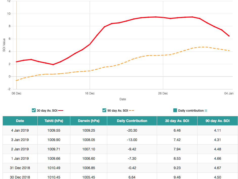
Also the SOI's daily contribution has really made a rapid reversal to negative values the last several days now, which probably is in part due to the MJO activity shifting towards 6-7 (West Pac).
I was really starting to personally be concerned about losing all of January the way things had been looking the last couple days in the long range even though I remained somewhat patient that we would round some kind of corner soon to hone in on when this much needed pattern change might start growing some legs. Salvaging the last half of the month in our region is still doable IMO.
Great write up MAG. Man...I sure hope you're right...
-
Here's an excerpt from what Horst had to say this afternoon:
Here in the Mid-Atlantic, however, a pattern so wholly owned by the Pacific jet--and devoid of blocking--is a tough thing for snow lovers and skiers. Glancing shots of cold air can make for some accumulating snows in places north of the I-80 corridor, but farther south the shallow cold pushes are so easily routed out that mild rain events are the norm. And this, my friends, is the pattern I see continuing into mid-month...and perhaps even into late month. (Yes, it can snow here in a mild pattern like this...but everything needs to line up just right, so it's a long shot...and it wouldn't last anyway.)
For weeks now, I've been hearing rumors of a "dramatic shift to cold, snowy conditions" in the big cities of the East--but these rumors are fueled by nothing more than very unreliable long range computer models. Of course, the frigid air hasn't arrived yet...and won't...for a couple/few more weeks. We need a wholesale shift in the upper-level pattern across the Arctic to make for a sustained southward push of frigid air. While we may actually observer (in reality, not in models) this process begin over the next week or two, for it to come to fruition here (in terms of sustain cold and significant snow) typically takes another week or two beyond that. So, while I'm not ruling out some brushes with winter here in the second half of January, I believe snow lovers' hopes for a significant spell of wintry conditions will hinge on the period from February 1st to March 15th. --Horst
-
1
-
-
I appreciate those of you who do not perceive me as negative. In the past I have been one of the most active cheerleaders for winter storms...when the pattern supported it. However, we have been in a lousy pattern, we are in a lousy pattern and we look to stay in a less than a lousy pattern for potentially a couple more weeks. I'm not going to get falsely excited when the reality is there is nothing to be excited about. When the pattern looks at least somewhat conducive to winter weather I will say so and jump aboard. Until then...
Carry on.
-
1
-
-
1 hour ago, Superstorm said:
Horst is one of best when looking at long range patterns, and he has been sticking with “real” winter starting Feb. 1.
.He reiterated as such today. Thanks for posting that. He also once again reminded everyone how unreliable long range models often are.
There "might" be a couple of brushes with winter later in January, snow lovers will need to wait until February for an actual wintery pattern.
-
First, I am not on any ledge or giving up or anything else. I just add what he says on here because quite frankly I don't know of anyone better at long range pattern recognition than Horst. He might not be right...I get it. He's not God. I do think that beyond his very high skill level it's prudent to consider his viewpoint as a possibility. Further, he is saying that of the next 2 months February looks far more wintery. He acknowledges that there will be "brushes" with cold and snow.
One thing he said a couple of weeks ago is that he saw January having a 4 to 7 day stretch of wintery weather. That sure is looking mighty good right now.
I'm sorry if I've been a thorn lately. I'm just not one to hang hope in something blindly. I'm going to step away for a good while and let you guys have fun without me and my "negative" posts.
-
6 hours ago, canderson said:
Horst punting January is not encouraging.
Horst punted January weeks ago and no one listened.
The fact that he is talking about a cold and snowy February IS encouraging.
If I could be totally selfish I would wish for our winter weather now when sun angel is low and temps are near their lowest on average.
In February 2010 I had a net 32" on the ground the morning of 2/10. I had grass showing 6 days later.


Central PA - Winter 2018-19
in Upstate New York/Pennsylvania
Posted
Yes..some of the 6z models showed confluence sending this baby a bit further south.
On the other hand, sometimes confluence isn't as strong as modeled, so there's that...
This setup sort of reminds me of 1/30/2010. We all remember what happened after that.")