

Itstrainingtime
-
Posts
16,416 -
Joined
-
Last visited
Content Type
Profiles
Blogs
Forums
American Weather
Media Demo
Store
Gallery
Posts posted by Itstrainingtime
-
-
^ reminiscent of storms from the 80s. Classic mix bag down here with crippling interior snows.
-
Just now, canderson said:
I'd think the intensity would overcounter any ZR right? Isn't ZR with heavy rain rates basically impossible?
I've had freezing rain with temps in the mid teens. If it's heavy it might pond on roadways on impact but trust me...it can get seriously nasty.
-
6 minutes ago, daxx said:
Yea fv3 gfs even worse. Still got time but starting to go downhill!
That was my point exactly. Lots of time to go but there's also much that can right and wrong with this.
-
13 minutes ago, bubbler86 said:
Personally I felt like it had a more smooth transition to a snowier solution, for this previous weekend system, than some of the more traditional models such as UK and GFS which I believe jumped around a bit more. I am surprised at all the NAM hate I keep reading about (mostly in the MA forum). No doubt it is a shorter range model but I lurked some over the last few years and although they all miss some times, the NAM seems quite good at catching late trends in storms within 48 hours.
As Nut said the NAM was really good in the 1/16 storm, and I think (unscientifically) that it does very well in general with large winter east coast storms.
-
Don't look at the GFS.
-
2 minutes ago, Maeve said:
At the age of 53 I keep getting younger and younger on here!
")
-
59 minutes ago, bubbler86 said:
That is quite the range. Do we all have that liberty of saying we nailed it if we get within 36" of the total? LOL. If so then I am locking in for this weekend. LSV sees 1"-37".
That range is due to a 4000' change in elevation. I believe the town of Mammoth Lakes is around 7000', while the summit is 11053'. Not uncommon at all for amounts to double from the village up to the summit.
-
31 minutes ago, JTrout said:
Good Morning Folks,
I found this forum last year(along with the circus of a forum down in the Mid Atlantic). I used to do a pay per year weather service forum. You guys are just as good and provide more detailed info, along with a lot more of it from multiple sources. I don't really plan to post a whole lot because I don't know enough to add any really useful information. It's really refreshing to know other people like me exist, when major weather of any kind come around to our area, my wife hates me. haha. Like, thinks I am nuts that I can spend so much time staring at the radar, looking outside, other forums, cranky's blogs/tweets, NOAA, Horst's site, Bobby M's facebook videos, etc.......All I am trying to say is, I appreciate you guys and everything you post. I finally joined the forum officially because I needed to get that off my chest. Also, even though I stalk the lower forum. I will not be posting this down there. Wayyyy to hostile and they probably don't consider southern Pa the Mid Atlantic for some reason. I have a lot of respect for those of you who have the balls to post down there.
Thanks
-Josh S.
Welcome Josh! And hey... guess what? You're right up the road from me. I live between Maytown and E-town! (though really just outside Maytown borough)
-
Oh to live in the Sierra...Mammoth Mountain has a "Special Weather Statement" for 4' - 7' of snow. That's not a typo on my part, that's feet.
What do they need to get a Winter Storm Warning for goodness sake?
That's the big boy that is headed east to a location near you this weekend.
-
 1
1
-
-
7 minutes ago, pasnownut said:
Im not sure why they are calling it a clipper, and if they are it needs to be called a Wyoming clipper, not an Alberta, cause that's where this thing pops onto the weather maps. Regardless, I'll take a couple inches and like it. Appetizer for the weekend main course.
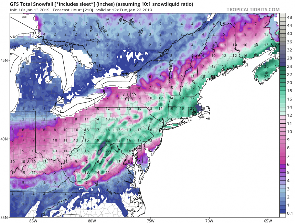
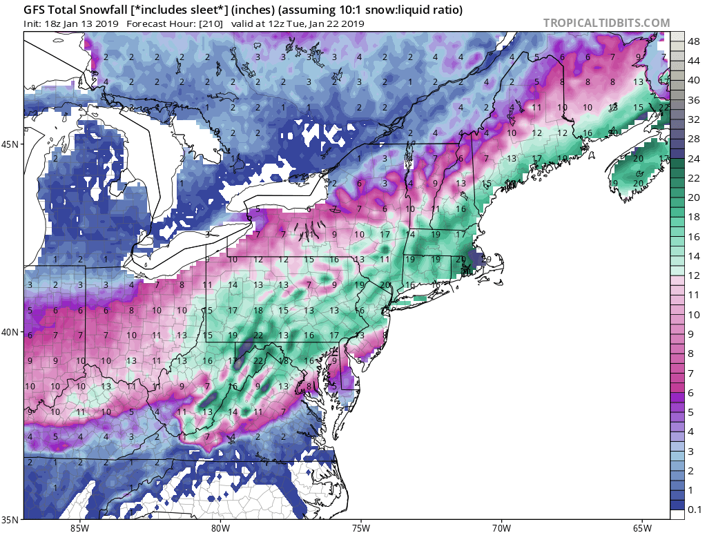
6z GFS verbatim is pure porn. I suggest every snow lover play the loop a few times. It appears that we are heading for a wild ride. Wowzers
Not parsing through details and "well some of that is not snow" stuff at this long lead, but i think it fair to say that it is going to be a busy busy time for sure.
Wyoming whitener?
I wanna watch that loop so bad but daddy told me to run fast from porn...
-
 1
1
-
-
33 minutes ago, canderson said:
CTP and Horst are bullish on the Thursday clippper.
Clipper has been getting stronger with each succeeding model run. Might very well end up being bigger than this past weekend for us. (yeah I know...not saying a lot, but for a clipper it looks pretty good right now)
-
1
-
-
A clear, cold & white morning with temps in the upper teens. Uneventful the next few days, but there's abundant fodder for snow lovers. A clipper system could bring a couple/few inches Thursday night...and a weekend storm could turn into a #Noreaster, tho track & temps are iffy.
-
2 hours ago, pasnownut said:
In MAG we trust......
")
Didn't take you long to stir the pot with our southern friends...
-
9 minutes ago, MAG5035 said:
It was pretty quiet in here during the lead up and discussion didn't really pick up until the last day or so. I also didn't realize we lost two of our more regular red taggers in here. I did remember Millville moving but I didn't know Heavy_Wx moved too (saw him down in the Mid-Atl thread).
I think we'll be having plenty to discuss now haha.
I value and thank you for your time and contributions here. I know when you get excited about a storm it's time for me to go back on the budget sleeping plan.
-
2
-
-
15 minutes ago, bubbler86 said:
Up to 4" here now....roads are covered again...this stuff is creeping north so some of you are going to get some more tonight.
It's making more progress north than east. Highly doubt anyone in Lanco gets in on it other than perhaps the extreme southwest corner.
-
13 minutes ago, pasnownut said:
I’m baacckkkkk
did ya miss me?
HI
Hopefully it'll be our turn soon enough...your pals down south are reaping white gold today.
-
1
-
-
37 minutes ago, Cashtown_Coop said:
Another bump or two, us southern guys might see a little more snow.
You should be in it now...
-
1 hour ago, Caveman said:
My thermometer that morning (outside and sheltered) hit -28F and then proceeded to do a 1 hour walk about...it was surreal! The snow was dry; everything was "crunchy"...nothing I've really experienced before and likely not again. Dead calm air and very quiet. I remember everything being just so brittle and "crunchy"...
Go O's!
Thanks for the information. I remember exactly what you described. Never thought I'd see those temperatures around here. As much as I love winter I don't know that I need to see it THAT cold again...
-
44 minutes ago, daxx said:
Oh man... The 12z Euro run is kinda epic late week and next weekend. Few inches Thursday night and Friday. Then a lot of snow next weekend. Southeastern part of the lsv would probably mix but still a good amount of snow. Let's hope it's right!
Think some interior areas N&W of Blue Mountain get over 2?
Looks like a prolific winter storm...and perhaps not the last...
-
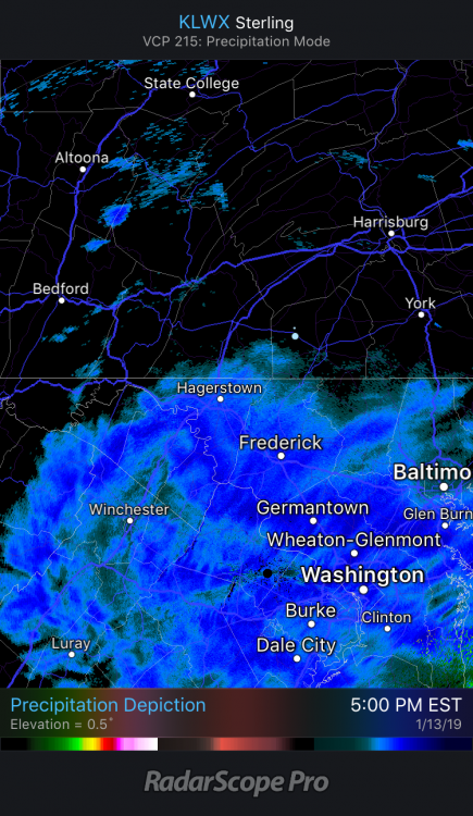
5 minutes ago, Blizzard of 93 said:
Light snow had started again in Marysville!
I'm further south and supposedly closer to the action but the sun is out here.
-
3 minutes ago, Cashtown_Coop said:
Period of mod snow last 45 min. 3.7”
Awesome...we had a few stray flurries around 9 and nothing since. My snow is actually melting.
-
4 minutes ago, Wmsptwx said:
.6 but most has melted off, to see any snow was a win for this one.
You might be in a really good spot next weekend...
-
Just now, Cashtown_Coop said:
It’s a steady light snow accum .1” to .2” / hr stuff. Really adds to the mood
As far as that cold, holy cow! I remember that week of 1994 as a kid. We were off the whole week and I remember my dad telling me it was -24 outside. I think Harrisburg hit -22 which is still their all time low
Flurries have just returned here.
You are correct about Harrisburg hitting -22. I remember that clearly. What I don't remember and what I'm curious about is how low did Thomasville get. Have to think they approached -30.
-
Just now, bubbler86 said:
I think it is amazing that the HRRR is suggesting the Delmarva is going to get ANOTHER 12" of snow.

I have family that live just north of Rehoboth Beach. They've done very well the past few years down there.

Central PA - Winter 2018-19
in Upstate New York/Pennsylvania
Posted
That's the storm I was referring to. When the record cold hit roads around my area were like driving on a washboard for 2 weeks.