

Itstrainingtime
-
Posts
16,470 -
Joined
-
Last visited
Content Type
Profiles
Blogs
Forums
American Weather
Media Demo
Store
Gallery
Posts posted by Itstrainingtime
-
-
Just now, Porsche said:
A few mid-morning thoughts on upcoming impacts across the Lancaster area. • A moisture-rich & fast-moving storm--in and out in ~20 hours. • Snow begins ~3pm SAT...may come down heavy w/ sleet for a few hours, then over to an extended period of freezing rain overnight.
6:47 AM - 18 Jan 2019-
New conversation
-
• A brief change back to snow is possible ~8am Sunday, then a quick end as gusty Arctic winds kick up. • Temps will fall throughout Sunday with a rapid refreeze of standing water/slush. • Low temps Sunday night in the single digits with sub-zero wind chills.
-
• Front-end accumulation of snow & sleet will have a very sharp gradient...with <1" in Philly up to 18"+ in northcentral PA. Lancaster will reflect this gradient...perhaps only 1" near the MD boarder up to 4 to 6" along the Turnpike. Perhaps 2 to 4" of snow/sleet in Lanc city...
-
• Ice accretion from the freezing rain Saturday night is the wild card. Surface temps are the critical factor...and this will vary town to town across the county...and so the amount of ice accretion may vary from 0.1" up to ~0.4". Tough to nuance such a complex storm.
-
Yeah...what he said.
")
-
2 minutes ago, Atomixwx said:
And?
There's so many I didn't copy/paste, I was suggesting if interested to go take a look.
- Seems like he's calling for 4"-6" along the "toll road"
- Perhaps 1" near the M/D line
- 18" in northcentral PA
- Long duration freezing rain down here tomorrow night
- Start time is 3pm, ends at 11am Sunday
- .1 - .4 of ice
-
If interested, Horst has just tweeted a bunch of his morning thoughts...
-
4 minutes ago, kerplunk said:
Just in:

Last map they put out had Lancaster at 3".
-
That Ralph Wiggum guy says the NAM is north and warm to whatever panel he's at.
-
Just now, canderson said:
Had around 1.5" or so total overnight. It's a really nice, fluffy snow - the best kind.
I guess it gets washed away tomorrow night though ehhhhhhhhhh
It's going to melt today long before we get to tomorrow night.
-
7 minutes ago, Wmsptwx said:
It looks like 1.4 to 1.6 over good part of state?
I had 1.3944" so no.
Still liking your 6" - 9" for your area? When I first saw that last night I thought you were too low...but that might be a pretty good call. Seems like warm air aloft always moves faster and farther than what's anticipated.
-
 1
1
-
-
7 minutes ago, bubbler86 said:
It has been much faster on the NAM, GFS and ICON. Finishing up earlier Sunday AM (later for you).
More progressive without any blocking...
-
I know the Euro can tend to run a little dry BUT it does seem like this storm has been slowly moving away from the huge QPF bomb of a few days ago.
-
Clipper is exiting w/ an inch or two of snow in its wake. Clouds will gradually break today w/ afternoon temps in the upper 30s; then back into the 20s tonight w/ brief clearing. SAT PM into SUN midday: Snow→Sleet→Freezing Rain→Rain→Snow Showers...then 36hrs of Arctic air.
-
Just now, bubbler86 said:
Going to get me this weekend. Based off how it looks now I would only expect 1-3" before change over. Euro seems like a plan rain storm. Need that low to transfer earlier!
Yeah. I think really the big question on tap for us is just how long we hold onto frozen before changing to plain rain.
-
Just now, Atomixwx said:
I always like to have clean undies. The whites.
Duly noted...and hopefully very quickly forgotten.
-
Just now, bubbler86 said:
I am the most southern member of the forum so probably some temps differences.
Yep, my work is 12 miles south of where I live and it was 29 here.
-
I really want to see the Euro come back south at least some today at 12z. Overnight run was nearly a non-event down my way.
-
1 minute ago, bubbler86 said:
Not very cold out this AM. 31 here. Snow compaction last night makes it hard to measure but guess 1.5 with snizzle falling right now.
I had 26 when i left for work at 4:30am.
-
Just now, Atomixwx said:
What surprised me is Brett Thackara (easily the most conservative of the TV Mets) with the 6-12 N&W of HBG.
I have to work today. I expect to be briefed.
I read your reply too quickly...was wondering why you were talking about your briefs...
I have to work as well. My company expects weather updates from me. Score!
-
Just now, Voyager said:
Still snowing lightly, but I didn't get near what some of you got. I put the dog out, and would say there's only about a quarter inch out there.
As for the NWS forecast...man, if this was all snow. They won't give me frozen accumulations in the point-click, but for Saturday night, they say 1-2 inches of "precipitation". Too bad most of that in that time frame will be taint.
Did they change the wording in your Winter Storm Watch? I know last evening for your area it was 6" or more.
-
NAM says "nah...keep scraping"

-
RGEM says I wear shorts Sunday morning:

-
CTP still has all of us in the LSV under a Winter Storm Watch, but for areas such as Dauphin, Cumberland, and Lebanon it's for the potential of 6" or more of snow. Lancaster and York counties is now 1" - 5" of snow. So to Blizzard of 93's point they've upped amounts from MDT north and west, and to my point they've somewhat lowered amounts down my way. (last night my watch was for 3"-5" like everyone else)
-
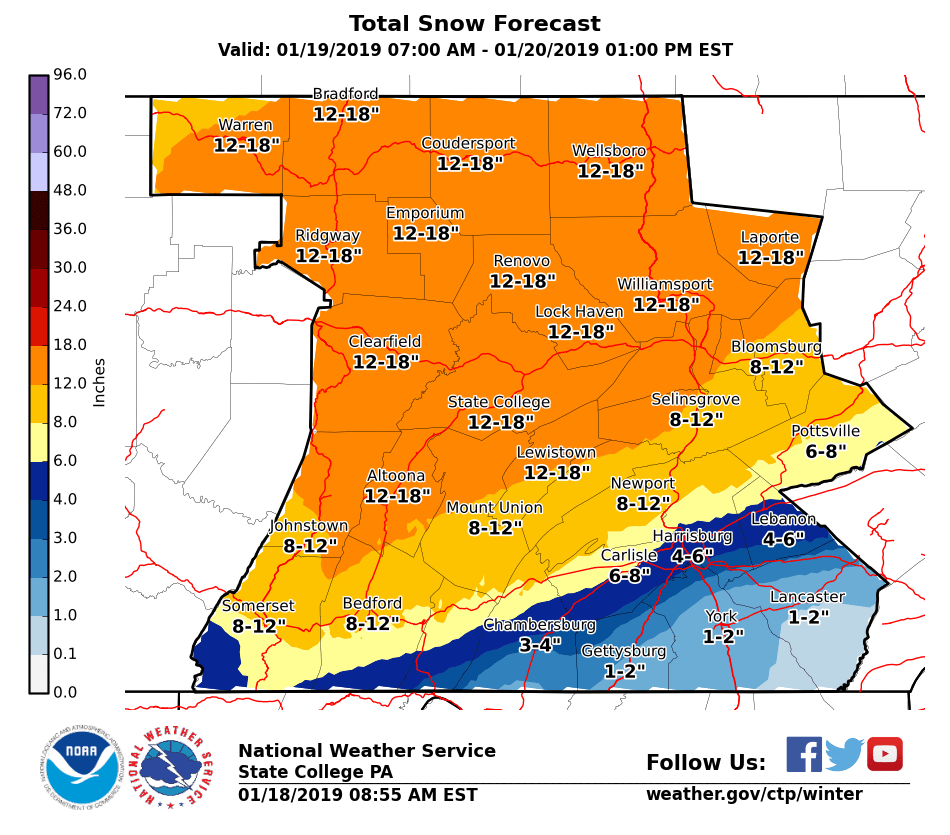
3 hours ago, Blizzard of 93 said:
CTP keeps slowly bumping up the snow totals on these maps for this weekend!
Here is the most recent update.

Good morning! Up for work and noticed that my total went DOWN some. CTP isn't upping totals for everyone in this thread...
-
Just now, Blizzard of 93 said:
Speaking of tonight’s snow, light snow has picked back up here in Marysville. We are now over 1 inch so far tonight.
Here as well and radar has blossomed.
-
Just now, 2001kx said:

Okay, that really is painful for me to look at.

-
2 minutes ago, bubbler86 said:
This is going to cause an "uptick" in forum activity. Cannot believe Nut is not here yet.
I don't know where he is but if he saw the NAM he probably busted one.


Central PA - Winter 2018-19
in Upstate New York/Pennsylvania
Posted
Just saw that, and given how big Dauphin is north to south I guess it's in the realm of possibility...