

Itstrainingtime
-
Posts
16,419 -
Joined
-
Last visited
Content Type
Profiles
Blogs
Forums
American Weather
Media Demo
Store
Gallery
Posts posted by Itstrainingtime
-
-
Just now, Cashtown_Coop said:
It’s a steady light snow accum .1” to .2” / hr stuff. Really adds to the mood
As far as that cold, holy cow! I remember that week of 1994 as a kid. We were off the whole week and I remember my dad telling me it was -24 outside. I think Harrisburg hit -22 which is still their all time low
Flurries have just returned here.
You are correct about Harrisburg hitting -22. I remember that clearly. What I don't remember and what I'm curious about is how low did Thomasville get. Have to think they approached -30.
-
Just now, bubbler86 said:
I think it is amazing that the HRRR is suggesting the Delmarva is going to get ANOTHER 12" of snow.

I have family that live just north of Rehoboth Beach. They've done very well the past few years down there.
-
Looks like snow is rapidly expanding north towards and into the LSV as Cashtown and Bubbler have already mentioned.
-
Just now, Superstorm said:
Tough for me to tell, but I believe so.
.I saw that Bob Chill mentioned that they would get 5-10" down there before the flip to ice.
-
6 minutes ago, bubbler86 said:
Picked this up from the Mid Atlantic Long Range thread. Really do not want to see this as it is life and property threatening. These are surface temps.

Somewhat reminiscent of January '94 when I reached -21 and -22 on consecutive mornings.
-
11 minutes ago, Superstorm said:
Euro showing massive ice event
.After some snow, correct?
-
2.25" here. Forecast and models did remarkably well here all things considered. Nice to see the ground white again.
-
6 minutes ago, pasnownut said:
Hey all I’m up at the cabin muzzloader hunting with a crew so I’m smokim cirrus in Tioga. Gonna be back tomorrow in time for the Eagles. Looking forward to sniffing out the next one so enjoy some for me. Sounds like I may see some during the game if coastal works for us in the LSV. Have 1.5” up here and snowed in n off Thursday night.
There you are...approaching 1" here with light snow falling. Hoping we see flakes flying with the pigskin later tomorrow...
-
16 minutes ago, bubbler86 said:
I have seen several model depictions showing snow tomorrow evening, coastal based, back into Western PA.
We are slightly over an inch here. First plow just came through.
So much uncertainty even now with the storm in progress.
-
Just now, canderson said:
Put a Nest can facing the street lol
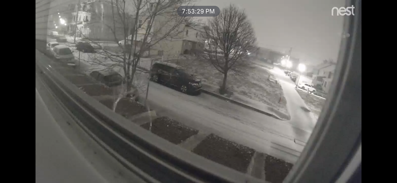
Looks very similar to what I have here.
-
Interesting read by Eric this evening - says he wouldn't be surprised if tonight UNDER performs...but now says we (Lanco) might be affected by the coastal tomorrow. He candidly admits he doesn't know what will happen. No changes to amounts...yet.
-
Flurries in Maytown and 30.
-
Where is Nutter? He's made like 3000 posts in the past 30 days and now's disappeared at showtime.
Overcast, 32 and the sky has that classic look here.
-
6 minutes ago, Gosnow said:
State college in afd hinting at perhaps heavier amounts due to deformation zone for se areas. Perhaps some bonus snow.
 Model Cycle and latest SREF indicates the potential for
2-3X the snowfall forecast for the far SE zones thanks to a
mesoscale deformation zone just to the north of a compact
700-500 mb closed low Sunday afternoon into early Sunday
evening. The SREF shows the nose of a -2 to -3 sigma, u-wind
anomaly (easterly LLJ) pointed right into that area. There will
be a very tight SSE to NNW gradient in snowfall within 20-30
miles north and south of the I-76 corridor. Will take the
measurable approach to gradually increase amounts across our far
SE zones (near and to the south of a KTHV to KLNS line Sunday
into Sunday evening), but still keep the bulk of Lancaster and
York counties below Winter Storm Warning criteria of 5 inches
for now.

BUFKIT time/height cross sections show a distinct second period
of moderate to briefly heavy snow from about 22Z Sunday to 04Z
Monday INVOF KLNS and points south from this potential
deformation snow band.
Welcome to the forum!
Seems like some boom and bust potential right up to and through game time. Will be interesting to see how this unfolds...
-
 1
1
-
-
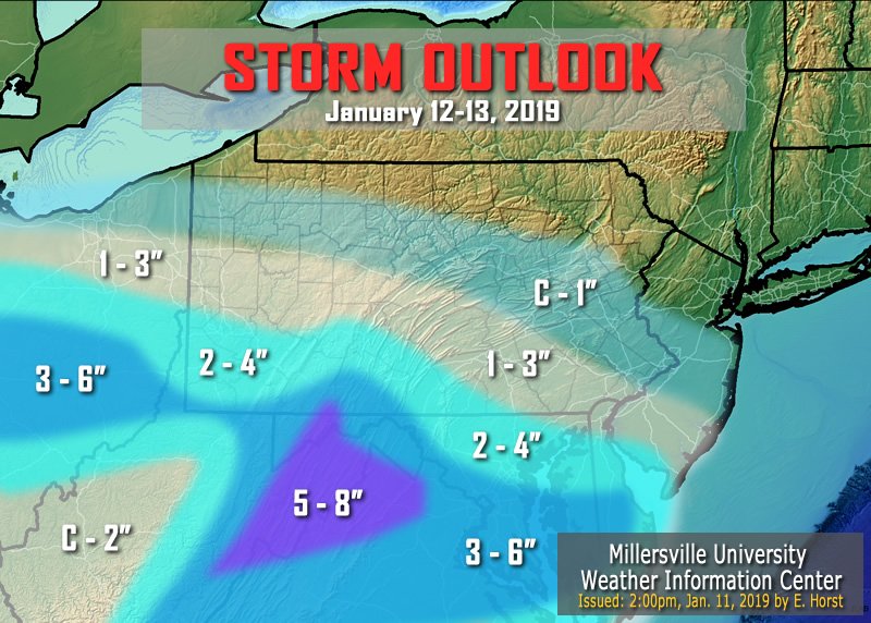
Eric's 2nd map with a bit of a nudge upward in some areas. (including mine)
-
1
-
-
3 minutes ago, Cashtown_Coop said:
So I’m the Mappy, Psuhoffman, Losetoa6 for our forum lol. I’ll take it.
Yes sir...you all "fringe" your way to a half foot.
")
-
 1
1
-
-
According to a post in the Philly thread JB likes 3"-6" at MDT.
Maybe this will be the one time this winter he's right.
Probably not. Time will tell.
-
2 minutes ago, Wmsptwx said:
Thinking Adams county is place to be, further east seems to dry up on most models. Also, weird storm...usually seeing stripe of winter storm warnings just west is good old fashion bowling ball...this guy just kinda dies out.
Yep, at least in my general local area this has a South Mountain special written all over it.
-
1 minute ago, MAG5035 said:
An actual look at overnight and 6z guidance would have shown some improvement overall with getting precip into central and LSV locations, esp on the Euro. I fell asleep early last night or I would’ve posted about it.
Right now it’s looking like a general 1-3” snowfall under I-80 with some possibility of 4-5” in the southern tier (esp west).
After I commented I did see that almost all 6z guidance came in either further north and/or juicier...interested to see what happens.
Certainly looks like DC metro is in line for a nice little snowfall.
-
I logged in this morning and saw no new posts for 12 hours including no 3:00am maps from Blizzard of 93 and that told me everything I needed to know.
-
1
-
-
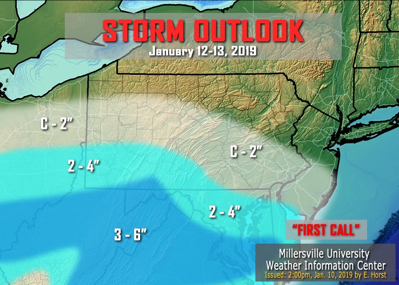
Horst going for a big Coating to 2" for most of us in the LSV. More south and southwest. Less north and east.
-
The past few pages have provided my afternoon entertainment, but I need to break in and let you know that the jackpot this weekend is going to be in central VA. That conway dude just reiterated that fact in the storm thread for the 713th time this week.
-
11 minutes ago, canderson said:
Ha! Yea it's barely worth tracking - 1" snow over 20 hours or so? I mean, any snow falling is good snow but watching someone in Virginia get 5-6" again will hurt. Let's hope the fabled upcoming pattern doesn't bust like that one in December!
I agree...and if we get skunked during the 1/20 - 1/23 time frame it will doubly hurt. Long range models have been banging for a biggin' for days and we need that to go woof and not poof.
-
Weekend event is looking about as hot as Roseanne Barr.
-
3
-
Central PA - Winter 2018-19
in Upstate New York/Pennsylvania
Posted
You might be in a really good spot next weekend...