WestMichigan
-
Posts
1,247 -
Joined
-
Last visited
Content Type
Profiles
Blogs
Forums
American Weather
Media Demo
Store
Gallery
Everything posted by WestMichigan
-
@michsnowfreak the NAM says you better turn your magnet back on or this will be too far south for DTW to cash in on the big snows.
-
How many think the snow totals will come down as the event gets closer or will it stay with the ridiculously high numbers the models are showing?
-
I really hope GRR has to eat a little crow on this one. NAM says GRR is maybe back in business after watching is drift south for the last few days. Would like to see a few more models arrive at the same solution for my area, but someone somewhere is going to get a nice snowstorm out of this.
-
At least the 12z GFS is keeping us from saying congrats Kentucky. Maybe we can settle on a track with only minor variations sometime before 24 hours out.
-
I was in 1st grade living in SE Ohio. I remember the relentless wind. We started on the warm side so not as much snow as many but it was still wild.
-
The NAM 3KM says no so fast to those large totals. I would hate to be a met out there right now.
-
Enjoy your taste of winter.
-
Nice to see you back.
-

Winter 2021-22 Short/Medium Range Discussion
WestMichigan replied to Chicago Storm's topic in Lakes/Ohio Valley
Wow, the NAM is pretty much a swing and a miss for most of the NE. -
Winter 2021-22 Short/Medium Range Discussion
WestMichigan replied to Chicago Storm's topic in Lakes/Ohio Valley
If we are cherry picking our models, then I will take the 12Z Canadian please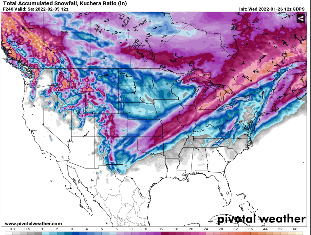
-
Only made it down to 10 at my house this morning. Lake Michigan doing its thing keeping us warmer. Continual light snow over the last few days is finally adding up. I didn't realize this but GRR is within 1.3" of their entire snowfall last year. Compared to others in the subforum it is a virtual snowmageddon in West Michigan.
-
You know it is ban when the pahandle of Florida outperforms nearly all of our forum on the 12Z Euro.
-
You can tell this NWS forecaster has been in the Michigan area for a while. On the other side of today`s forecast challenge, to the southeast of Grand Haven and Big Rapids, we are going increasingly sunny through the day. It can be an occupational hazard to go optimistic with sun in January when we are socked in with clouds early in the morning, but there are some reasonably large holes in the clouds opening up on satellite, and some of the clouds are already thin enough to see the moon through. Weak subsidence due to the high/ridging today should continue to erode the cloud cover, while increasing south winds will make an attempt to bring that drier and cloud-free air in northern Indiana/Ohio our way.
-
Aren't we all
-
Grew up in Caldwell, OH and moved here from the Columbus, OH area in 2010.
-
I can't agree with you more. After watching my hometown in SE Ohio get a double digit storm yesterday I am ready for something like that here.
-
WAD or CAD both are a precip nightmare. Hoping things turn around soon or this summer is going to be ugly.
-
Have to like the 18Z NAM doughnut hole over Noble County.

-
Michsnowfreak is trying hard to reel this one in.
-
Picked up a surprise 1-2" overnight as the LES bands came inland more than expected. Closer to the lakeshore there was about 4" in Zeeland where I work. Guessing even more in Holland and points south from there.
-
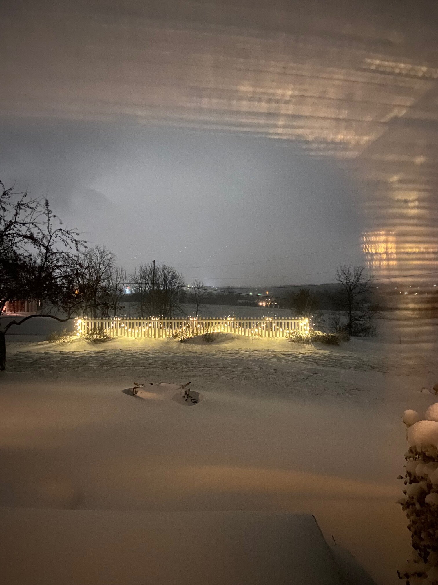
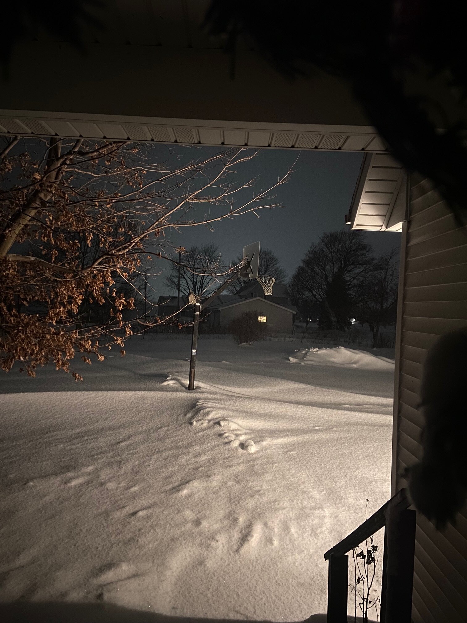
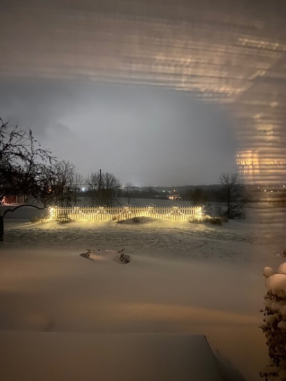
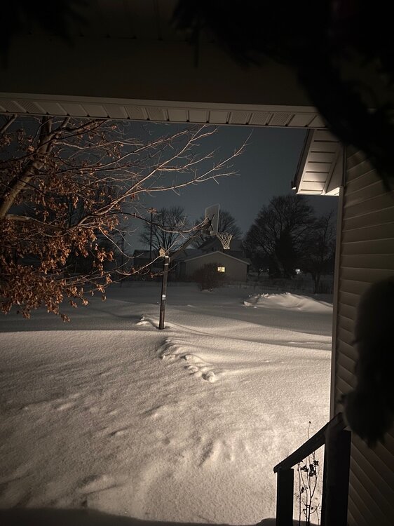
Living on a near treeless hilltop I have absolutely no idea how much snow fell yesterday and today. This morning I had bare ground and drifts over the top of my snow plow. I am gong to have to go with the NWS average for my area but with less wind today I am sure the bare ground is getting covered up. Sure looks like winter out there. These pics are from last night. I didn't get any pics this morning.
-
Wind and snow reducing visibility to under 1/4 mile at times. Roads are a mess after the slightly above freezing temperatures yesterday. Looks like it will be a fun ride home tonight. Hopefully we can keep the winds from turning too far NW longer than the models are predicting and get in on the LES for a longer period of time.
-
Winter 2021-22 Short/Medium Range Discussion
WestMichigan replied to Chicago Storm's topic in Lakes/Ohio Valley
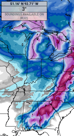
A little different story on this side of the lake. Confidence is relatively high for major travel impacts over wrn Lwr MI on Wednesday due to a combination snow showers (heavy at times), blowing snow, winds gusting to 40-50 mph, and falling temps. Frequent whiteouts and abruptly plummeting temps will lead to treacherous/icy roadways and conditions in which we often see numerous slide offs and sometimes even multi-car pile ups on the major interstates/highways. Total snow amounts are a bit more uncertain though since the high winds on Wednesday will spread the snow out, sending multi-bands well inland. This will probably limit amounts at the immediate shoreline with displacement of higher totals farther inland toward the US 131 corridor. Even where amounts are not too excessive though, feel the combo of elements and occasional whiteouts/squalls/near blizzard conditions warrants having a warning out on Wednesday. -
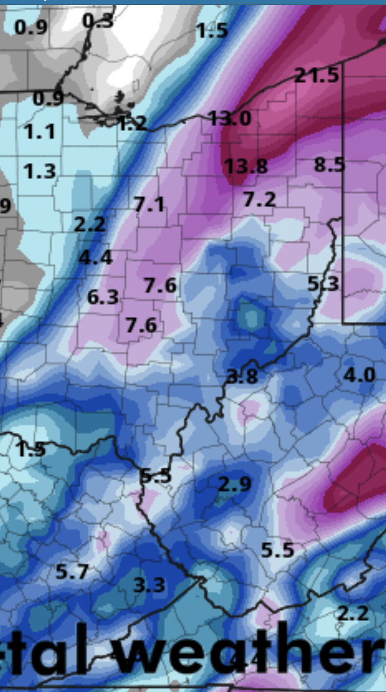
5.7” at GRR and probably closer to 5” at my place. Nice seeing it completely white outside for the first time this year. It was definitely a very dry fluffy snow which is very different than all the wet snow we have had so far this year.
-
Aomori/Hokkaido, Japan winter
WestMichigan replied to Mercurial's topic in Outdoor and Weather Photography
URL signature expired for all these links