

WestMichigan
-
Posts
1,372 -
Joined
-
Last visited
Content Type
Profiles
Blogs
Forums
American Weather
Media Demo
Store
Gallery
Everything posted by WestMichigan
-
1.07" from two separate storms last night. The grass is green and growing rather fast. Corn in the fields is trying to make up for lost time and has put on quite a bit of growth in the last two weeks.
-
I am going out on a limb here and saying you got rain last night. Not sure why all the complaining.
-
If you aren't east of US-131 then it isn't raining right now. We have had some in the past week that missed the GRR area also but I noticed on Monday around Conklin it is still quite dry and like you mentioned the immediate lakeshore is dry also.
-
We have thick fog and maybe smoke, maybe not. Too foggy to tell this morning.
-
We have thick fog and maybe smoke, maybe not. Too foggy to tell this morning.
-
hardypalmguy might have to change his name to hardycactusguy
-
GRR with a little bit of sarcasm/humor in their afternoon AFD. Smoke continues to linger across parts of West Michigan, though some improvement has been noted over central Lower Michigan the past few hours. As ridge of high pressure moves east of the area tonight, winds will becomes SE, and this should prevent the somewhat more pristine air to the north from advancing significantly farther south through lower Michigan, and as a result forecast will continue to include areas of smoke through Thursday.
-
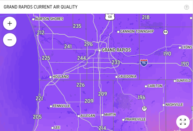
Accuweather was showing readings as high as 326 in my area about 30 minutes ago.
-
accuweather
-
-
1 mile visibility at GRR just before noon. It is crazy outside right now.
-
Sounds like mosquito heaven.
-
Ended up with a little over 1.5" here today. Thankfully the lake shadow didn't seem to come into play.
-

Spring 2023 Medium/Long Range Discussion
WestMichigan replied to Chicago Storm's topic in Lakes/Ohio Valley
You cut off the date, when is that? ^ -
With all those leaves it doesn't look like much grass would grow there anyway.
-
No heat? How many 90 degree days has GRR had? I count 5 so far. That doesn't sound like no heat. You could make a case for lower humidity than normal.
-
Other than lack of rain, I am not sure anyone is complaining about the low dewpoints. Except for our resident palm tree lover.
-
Where was a discussion like this in the winter instead of the usual decline in QPF that seemed to occur with nearly every storm. We definitely need the rain so this is a good thing. Latest GEFS/ECMWF ensembles support potential for three quarters of an inch to an inch of rainfall from Sunday through Tuesday. A gradual trend upward a bit in ensemble qpf has been noted the past 48 hours which seems reasonable given the evolution of the upper level pattern.
-
And so it begins....
-
A tale of two different regimes here.
-
Same thing here. I did manage to sneak in 0.26" around 11:00 last night. Kinda surprised me given it was well after dark and the radar was clear in my area when it started.
-
Spring 2023 Medium/Long Range Discussion
WestMichigan replied to Chicago Storm's topic in Lakes/Ohio Valley
Continuing the theme of dry It is likely that we`ll finish May without another drop of rain. Assuming this holds, our climatological station at Grand Rapids will finish the driest month of May since the Dust Bowl of the 1930s. May 1936 registered 0.72" of total rainfall, which is the driest May on record, while this May is only a tad wetter at 0.84", which would rank 2nd driest at Grand Rapids. Other sites such as Lansing and Muskegon, assuming no more rain, would end up with the 5th driest May on record. -
Tell that to the fruit tree growers.
-
When I first moved to Michigan in 2010 I distinctly remember in Holland waking up multiple times to tstorms very late at night to right before sunrise. It almost was regular enough to make me think this is how it goes in Michigan. Then reality set in over the next 12 years and I realized this was an anomaly, not the norm.
-
I haven't found any alternative yet. Hopefully someone has.


