beanskip
-
Posts
2,064 -
Joined
-
Last visited
Content Type
Profiles
Blogs
Forums
American Weather
Media Demo
Store
Gallery
Everything posted by beanskip
-
80 percent of Tallahassee lost power during Hermine.
-
This "stall in the gulf" thing seems like a thing. I remember the models picking up on that pretty early with Matthew. Bears watching.
-
Lol, the ever-consistent ICON makes a tiny little shift vs. prior run -- from Yucatan to .... Key West!
-
18z NAM had low in Gulf.
-
I know you haven't gotten a ton response on these posts, but I think they are wise and on point. On the one hand, the model consistency on this storm has been breathtaking. On the other hand, if there is going to be a surprise, it's not going to be on track (a track which hasn't budged, for the most part, for 3 days), it's going to be old Larry Cosgrove-esque CAD over- (or under-) performance. You and I have been on these boards a long time and two things always seem to happen: 1) The CAD is underestimated 2) So is the warm nose. That could be a particularly ugly combination with this sucker.
-
Definitely didn’t translate through the run ….
-
18z ICON dropping the 500mb low further south — just through 21 hours. Eventually these small shifts add up ….
-
I was trying to make that point a bit more charitably .... ;-)
-
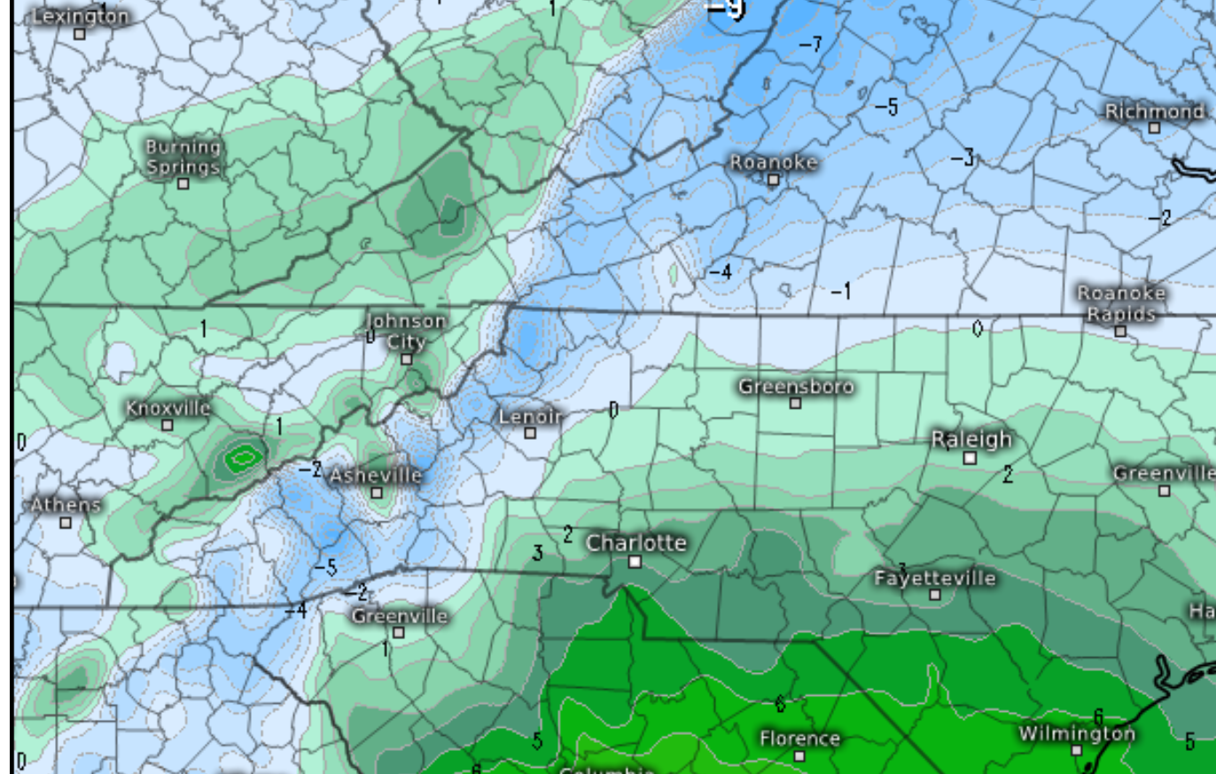
Pretty scary map here -- 12z Euro 850 temps at 9 a.m. Sunday morning, with plenty of QPF piling up. 2m temps around 26 in CLT at this time.

-
Yes and the 850 low on the RGEM was just about 40 miles south of the 6z position while over Georgia. Within the model margin of error? Probably. But I've also seen life (and death) by paper cut where 4 straight 20-40 miles shifts suddenly turned into a game-changing trend for some folks. Worth watching when in places like my old stomping grounds, 10 miles can make all the difference with the sensible weather.
-
I know everybody is hanging on every wobble (and that's a lot of the fun of it all), but the 30,000-foot view is worth mentioning -- this is quite remarkable model consistency over the past 36 hours or more.
-
18z GFS 500 and 850 lows actually a bit south of 12z positions at 60 hours.
-
850 temps significantly warmer at 72 hours of 12z euro. Upper features a little faster and maybe a tick south.
-
Nice little south jog vs. 0z for 12z CMC at 500 mb.
-
Posts like these are why this board is so great.
-
6z GFS has 850 low at 90 hours over Roanoke. 12z NAM at 84 hours has it over ... Athens. That's a pretty big spread.
-
Great trend and track for NAM but man, it's a sleetstorm for most outside of mountains until the backside comes through.
-
Man, 12z NAM got MUCH more aggressive with the CAD. Dewpoints 3-8 degrees colder from GSO down to Atlanta, vs. prior runs.
-
Man, the CMC has the upper features moving pretty much due east from Texas/Oklahoma to Birmingham, then that sucker hangs a hard left and cuts up through western N.C. -- really screws D.C., among others.
-
Seems like the shift in upper features didn't really translate to surface/sensible weather. Probably just model noise which will sort itself out.
-
ICON was pretty similar to past runs until 96 hours - then it really holds the 500mb low well to the south of prior runs -- Augusta instead of Asheville.
-
18z drops almost 2 inches of QPF into 2m temps in the mid-20s for the duration of the storm west of I-77. Doesn’t matter the breakdown of p-types … that’s some serious shit.
-
Yeah this is SOOO true. Now that I'm just an observer from afar, it helps check my "excitement bias" -- the two main biases are underestimating the "nose" and ignoring model issues with boundary layer temps. Can't tell you how many times I've been a sucker for those who say "meh, heavy precip rates will overcome those +3 BL temps" and then cursed my naivete as I watch it rain. Having said that -- good luck, everyone, from Tallahassee. I'll be rooting hard for the BIG DOG!
-
Agree. Lots of Twitter accounts tonight are claiming to be storm chaser/spotters -- but they only have a couple hundred followers and are from Indiana or someplace. May or may not be legit.
-
0z GFS -- east at 12 hours vs. 18z at 18 hours.