beanskip
-
Posts
2,064 -
Joined
-
Last visited
Content Type
Profiles
Blogs
Forums
American Weather
Media Demo
Store
Gallery
Everything posted by beanskip
-
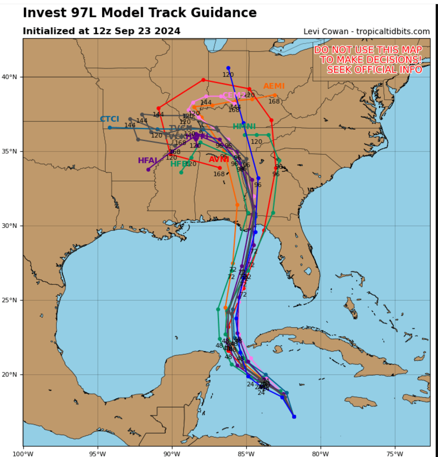
Pretty nice shift east with the 12z Euro. Probably one of many track changes, but this one hits the incredibly-maligned Taylor County area yet again.
-
Pretty tight spread for a storm still in the womb.

-
Oh I know that. I'm asking about the biases of the HAFS vs. the retiring models.
-
Well, to answer my own question, there damned well better still be a "overintensity" bias because the 6z HAFS-B is at 904 mb at 75 hours.
-
How has the verification of the HAFS models been compared to the HWRF and HMON (which they are retiring, correct?)? I know the HWRF and HMON often overestimated intensification (although I also remember them being the first to catch on to the idea that Michael would blow up). Is the same a bias of the HAFS? Any track biases observed? EDIT: I'm prompted to ask as I see the 6z HAFS-B down to 978mb before even reaching 20N. #gulp
-
Wait, haven’t I seen this movie before? GFS and hurricane models near Panama City and Euro way east with a Taylor County hit?
-
HAFS suite running for first time off Invest 97. HAFS-A is 953 mb with a 30-A area landfall (between FWB and Panama City). HAFS-B is 960 mb and landfalls around Mexico Beach.
-
Looks like there are going to be a lot of relieved people in Tallahassee tomorrow (including me). The sharp cut off of precip on the storm's west site and some subtle trending east with models and track could make this a minor event with an inch or so of rain and some modest winds. Unfortunately, another tough hit for Taylor and Dixie counties.
-
Super unimpressive first recon pass -- didn't even find pressure as low as the current advisory.
-
Pretty unimpressive recon data so far -- looks like the latest pass may have hit 1004. In model news, the first 0z run -- HRRR (yeah I know) -- made a big shift east from its 18z run, passing east of TLH, which would be helpful to me.
-
Is the Tropical Tidbits recon page broken? Trying to figure out why no missions scheduled?
-
Hurricane models starting to get frisky on strengthening. 18z runs of HAFS and HMON have Debby sub-990 mb when making landfall on Big Bend. Unfortunately, it's also showing a very Idalia-like track. Those folks just can't take another hit, even from a strong TS/Cat 1 hurricane. 18z GFS also was stronger than prior runs with a 997 mb Florida landfall. Something to monitor as models get a better fix on the center.
-
AIFS even stronger -- sneaks down to 999 before landfall.
-
Sorry, I'm talking Florida landfall. You said "strongest yet into the Big Bend" -- was trying to reconcile that.
-
Maybe I'm looking at wrong Euro, but the 12z run I see is 1007 mb at landfall?
-
FWIW, the storm is still so unidentifiable, two of the hurricane models (HMON/HAFS) have lost the ability to model the system in their 12z runs.
-
Pretty remarkablly anomolous severe event Jan. 8/9 over panhandle
beanskip replied to beanskip's topic in Southeastern States
I've seen hurricane AFDs not written that ominously! -
Pretty remarkablly anomolous severe event Jan. 8/9 over panhandle
beanskip replied to beanskip's topic in Southeastern States
"Not great Bob." -
Rare 70-knot lower level jet with sub 990-low and warm front pushing ashore. Even shy of severe threat, looks like non-storm related straight line winds that could gust over 50 mph. Storm warnings for 13-15 foot swells. Basically, a rare, major event for western Florida, among other places.
-
12z Euro trending a bit east. Enough to matter for Cape Cod.
-
Saw this in the TLH discussion a few moments ago: Area Forecast Discussion National Weather Service Tallahassee FL 1108 AM EDT Fri Sep 1 2023 ...New UPDATE... .UPDATE... Issued at 1108 AM EDT Fri Sep 1 2023 Torrential rainfall rates with an extremely moist air mass are the main concern today. Earlier this morning, the weatherstem at the Ochlockonee Boat Ramp in Franklin County had an instantaneous rainfall rate of nearly 6.5 in/hr. PW values are in the extremely moist 2.2 to 2.4 inch range. We also have a backdoor front our Florida counties that will serve as a focus for further development today. Will be watching trends closely to see if a Flood Watch will be needed.
-
Man this thing is really trying to take a right turn. Steinhatchee may still be in the game for an eye passage at this rate. Tallahassee could really be dodging a bullet.
-
This 18z Euro track is meterological chicken if I've ever seen it -- I mean it basically trucks due north until the very last second, then it gets pulled NE, then it kind of turns back NNE. That's going to make for some tense radar-watching in the morning.
-
Close to nowcasting, but still some value from 18z runs imo. Both of the HAFS are reflecting the failure of Idalia to get west of 85.0 and are now showing slightly more eastern solutions. Every inch, foot and mile matters for the angle of approach and the windfield for Wakulla's coast, Tallahassee and others.
-
85 W Longitude a pretty good measuring point for track. If it never gets on the plus side of 85, that will be good news for TLH. If it sneak across -- even for a bit -- that won't bode well.