Blizzard of 93
-
Posts
13,024 -
Joined
-
Last visited
Content Type
Profiles
Blogs
Forums
American Weather
Media Demo
Store
Gallery
Everything posted by Blizzard of 93
-
Central PA Winter 25/26 Discussion and Obs
Blizzard of 93 replied to MAG5035's topic in Upstate New York/Pennsylvania
No dusting or evidence of any flakes here last night either. The Old line “Never count on a Clipper” rings true again. -
Central PA Winter 25/26 Discussion and Obs
Blizzard of 93 replied to MAG5035's topic in Upstate New York/Pennsylvania
Lol, just what they needed… -
Central PA Winter 25/26 Discussion and Obs
Blizzard of 93 replied to MAG5035's topic in Upstate New York/Pennsylvania
18z Euro brings a coating to many of us by tomorrow am with the overnight Clipper. -
Central PA Winter 25/26 Discussion and Obs
Blizzard of 93 replied to MAG5035's topic in Upstate New York/Pennsylvania
Lol, come on now, I went lower than many in the January storm forecast contest for MDT & won it with my 12.5 guess. You would have won the contest this time if we had done one this past weekend. I look forward to the next chance! -
Central PA Winter 25/26 Discussion and Obs
Blizzard of 93 replied to MAG5035's topic in Upstate New York/Pennsylvania
I think we have a long way to go until true Spring arrives this season. We have a few potential Winter events to track through next week. Then, we likely warm up for a week to 10 days. After that, the Teleconnections & MJO forecast indicate that mid March through at least early April could be a return to a colder pattern with the trough in the east. I think we are tracking Winter storm chances through Easter week in early April this year. It fits the same pattern that we have had since around Thanksgiving. Any warm ups have been brief & i think that continues. -
Central PA Winter 25/26 Discussion and Obs
Blizzard of 93 replied to MAG5035's topic in Upstate New York/Pennsylvania
Early next week still looks interesting on most models for a snow to mix scenario with a wave approaching from the center of the country. -
Central PA Winter 25/26 Discussion and Obs
Blizzard of 93 replied to MAG5035's topic in Upstate New York/Pennsylvania
As @Mount Joy Snowman mentioned, most overnight models shifted south overnight for the Thursday potential light event chance, but close enough to keep an eye on. The 6z AI Euro & AI GFS are much closer for Thursday.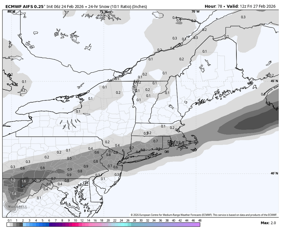
-
Central PA Winter 25/26 Discussion and Obs
Blizzard of 93 replied to MAG5035's topic in Upstate New York/Pennsylvania
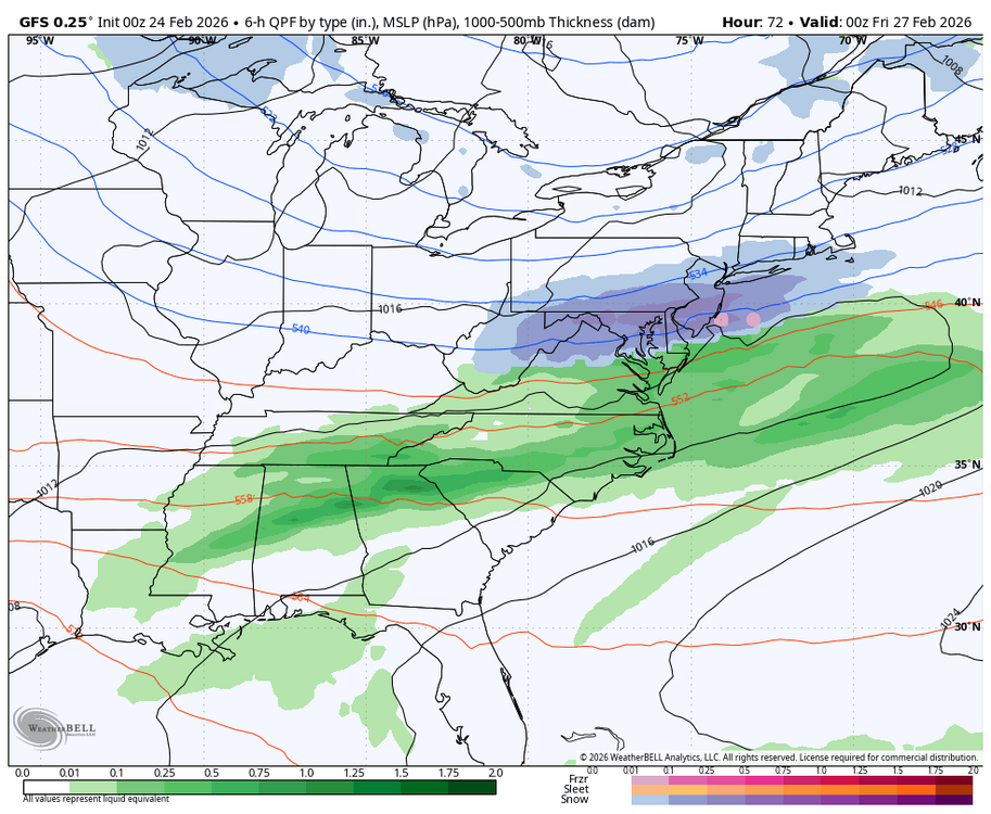
The 0z NAM & 0z GFS both bring snow to southern PA for the Thursday chance.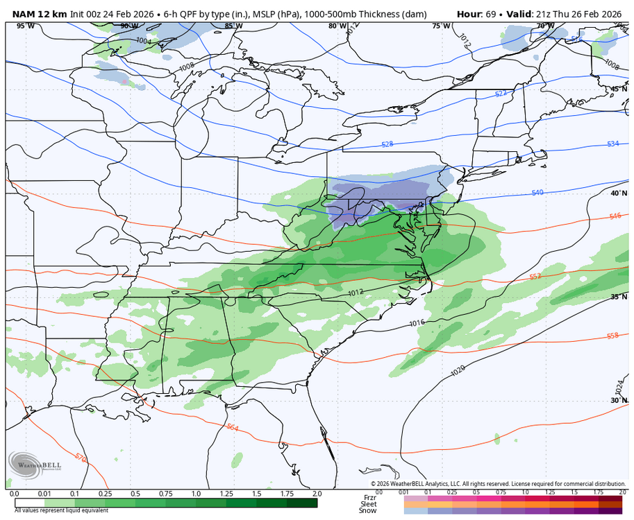
-
Central PA Winter 25/26 Discussion and Obs
Blizzard of 93 replied to MAG5035's topic in Upstate New York/Pennsylvania
I’ll take it after the potential of getting shut out was on the table with no snow sticking up until sundown last evening. -
Central PA Winter 25/26 Discussion and Obs
Blizzard of 93 replied to MAG5035's topic in Upstate New York/Pennsylvania
Sorry to hear about this! It is a tough no win situation many times. Most people have no idea how many pieces must come together for a Winter storm to materialize in a localized area. When you add in significant business decisions that can impact the bottom line, it can get really complicated & polarizing. -
2/26 - Follow-up Hopium Battlezone Storm
Blizzard of 93 replied to DDweatherman's topic in Mid Atlantic
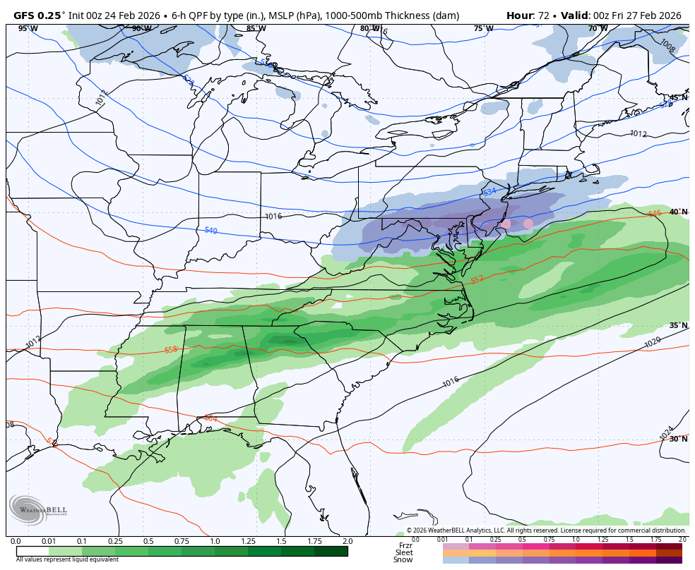
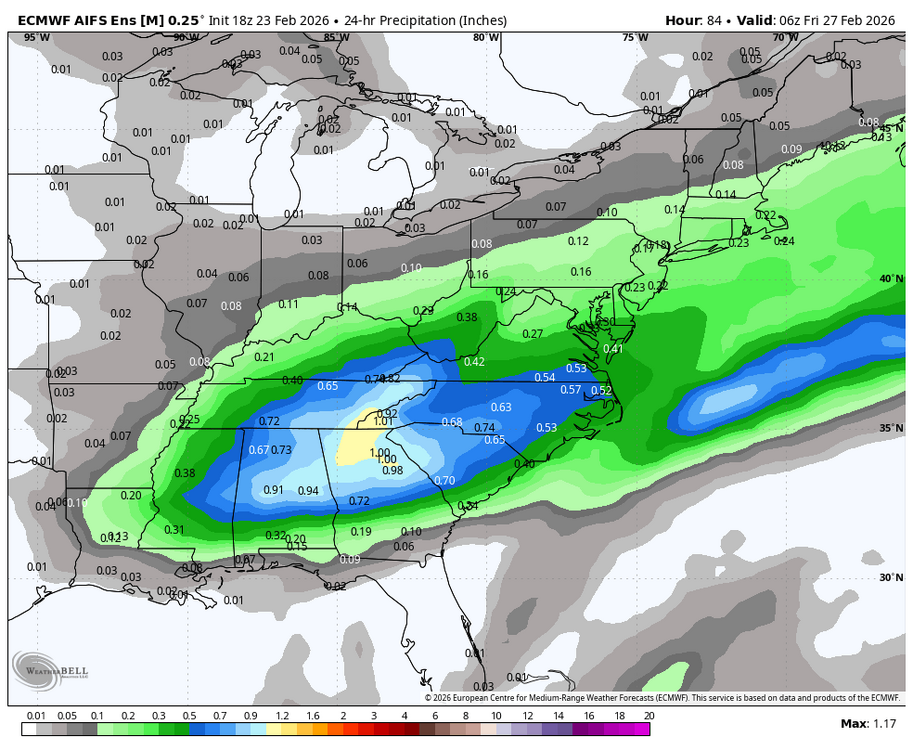
Here is the 18z AI EPS. Not much snow this run, but plenty of precip to tap into if it takes the right track, maybe there could be some potential.

-
2/26 - Follow-up Hopium Battlezone Storm
Blizzard of 93 replied to DDweatherman's topic in Mid Atlantic
The 18z AI Euro was well north of the Op Euro.
-
Central PA Winter 25/26 Discussion and Obs
Blizzard of 93 replied to MAG5035's topic in Upstate New York/Pennsylvania
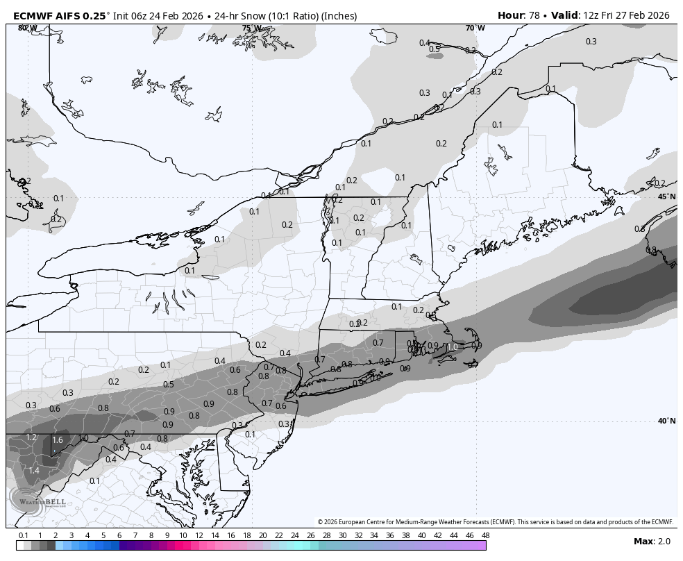
3.8 in Marysville for my yard. Frustrating storm for sure, but at least most us still ended up with a solid Advisory level storm, but it could have been so much more with a few adjustments. On to the next one! This Thursday is looking like our next chance. -
Central PA Winter 25/26 Discussion and Obs
Blizzard of 93 replied to MAG5035's topic in Upstate New York/Pennsylvania
Good night & you should be able to add to your total in the morning with several more hours to go until the snow wraps up towards daybreak. Tomorrow, we get back to tracking the next chapter of this Winter. -
Central PA Winter 25/26 Discussion and Obs
Blizzard of 93 replied to MAG5035's topic in Upstate New York/Pennsylvania
Moderate snow in Marysville continues at 11:45 pm. Eyeballing about 2 inches. It looks beautiful outside with snow clinging to everything. -
Central PA Winter 25/26 Discussion and Obs
Blizzard of 93 replied to MAG5035's topic in Upstate New York/Pennsylvania
CTP recently updated their discussion. -
Central PA Winter 25/26 Discussion and Obs
Blizzard of 93 replied to MAG5035's topic in Upstate New York/Pennsylvania
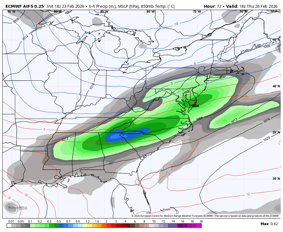
DISCUSSION... KEY MESSAGE 1: Light to moderate snow continues tonight as the western edge of the precip shield from a strong coastal storm impacts central PA. Rain turned to snow across the lower Susq valley around 5 PM. Since sunset, accumulation rates have been near 0.5"/hr in some of the snow bands across portions of the Lower Susq Valley and farther north towards Schuylkill Co. A secondary band in central PA, located within an inverted trough, has been producing snowfall at rates of 0.25-0.5"/hr. Expect similar intensities through about 2-3 AM as easterly isentropic ascent at midlevels is maximized. Still a medium chance (40-70 pct) that 1"/hr rates push into far eastern Lancaster County between midnight tonight and sunrise on Monday, but by and large the heaviest snow bands will miss our CWA to the east. Storm total snow (which includes snow that fell and subsequently melted this AM) is expected to range from 4-8" from Schuylkill Co south into Lancaster County and southeastern York County, with locally higher amounts possible in northeast Lancaster County and the higher terrain of Schuylkill County. Totals of 3-8" still expected in the higher terrain of the central ridge and valley region intersected by the north-south oriented snow band in the inverted trough. Lower amounts at lower elevations and on paved surfaces. Much of the accumulation is over by sunrise Monday, with lighter snow continuing through the morning in spots. -
Central PA Winter 25/26 Discussion and Obs
Blizzard of 93 replied to MAG5035's topic in Upstate New York/Pennsylvania
Come on heavier band… keep drifting south…just another 20 miles…you can do it! (now I’m talking to the radar…lol…this storm really has got to me…) -
Central PA Winter 25/26 Discussion and Obs
Blizzard of 93 replied to MAG5035's topic in Upstate New York/Pennsylvania
I like the band on radar that looks to be working its way south along Rt. 15 in Snyder & northern Dauphin & Perry county. Hopefully that works its way soon into our area & the Harrisburg area. -
Central PA Winter 25/26 Discussion and Obs
Blizzard of 93 replied to MAG5035's topic in Upstate New York/Pennsylvania
Moderate snow with decent flake size continues in Marysville. Eyeballing a little over an inch on the car tops & yard. Roads & sidewalks are covered, but a little less on them due to taking longer to cave. -
Central PA Winter 25/26 Discussion and Obs
Blizzard of 93 replied to MAG5035's topic in Upstate New York/Pennsylvania
It should snow all night… See the @MAG5035 post above. The storm is still sitting right along the DelMarVa coast. -
Central PA Winter 25/26 Discussion and Obs
Blizzard of 93 replied to MAG5035's topic in Upstate New York/Pennsylvania
Snow has made it back west to @MAG5035 in Blair county. All of that precip will need to work its way back east through early tomorrow morning. We have several hours of snow to go. -
Central PA Winter 25/26 Discussion and Obs
Blizzard of 93 replied to MAG5035's topic in Upstate New York/Pennsylvania
MDT last couple of Obs this hour is down to .5 mile visibility and they made it down to 32 degrees. -
Central PA Winter 25/26 Discussion and Obs
Blizzard of 93 replied to MAG5035's topic in Upstate New York/Pennsylvania
Side streets have caved in Marysville. Lol, only 12 hours later than I had anticipated last night… -
Central PA Winter 25/26 Discussion and Obs
Blizzard of 93 replied to MAG5035's topic in Upstate New York/Pennsylvania
I like seeing radar in the last hour pushing the main precip shield back north & west beyond State College & Altoona. Hopefully we get into some heavier bands before the low exits east overnight.