Blizzard of 93
-
Posts
13,024 -
Joined
-
Last visited
Content Type
Profiles
Blogs
Forums
American Weather
Media Demo
Store
Gallery
Everything posted by Blizzard of 93
-
Central PA Spring 2026 Discussion/Obs Thread
Blizzard of 93 replied to Voyager's topic in Upstate New York/Pennsylvania
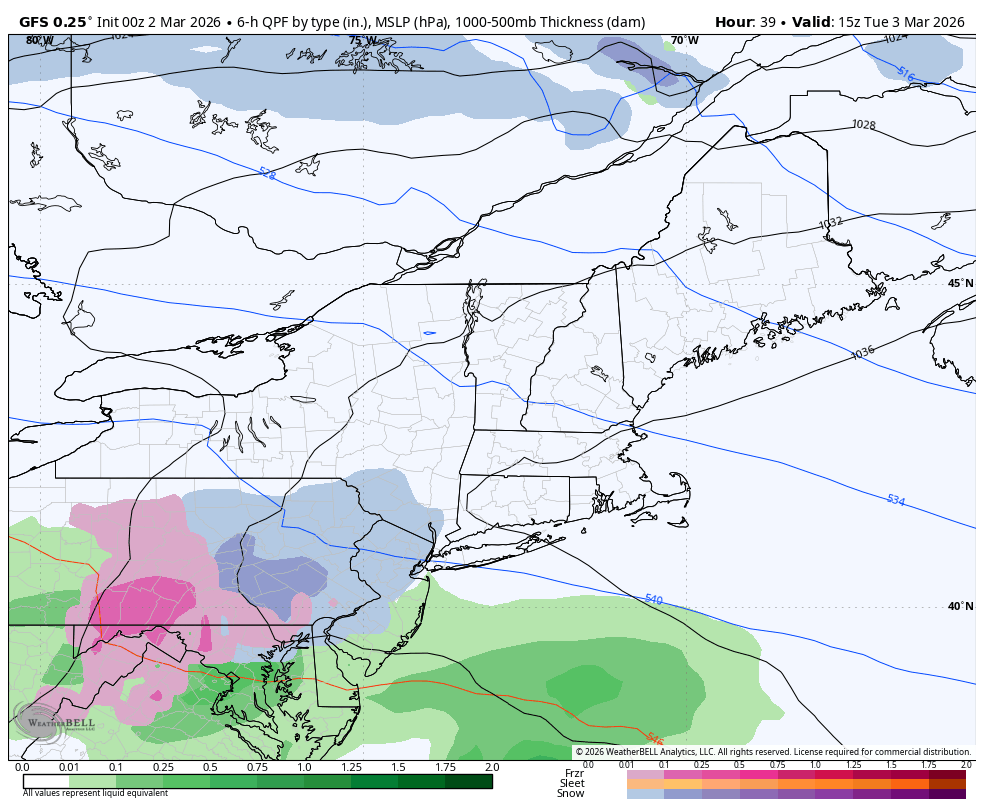
0z GFS is bringing a little more juice with wave 2, bringing it in earlier with a little more snow this run for the LSV .

-
Central PA Spring 2026 Discussion/Obs Thread
Blizzard of 93 replied to Voyager's topic in Upstate New York/Pennsylvania
By next Friday, the cold returns. It is showing across all ensemble guidance that the trough is back in the east by mid month. We are far from done with Winter. -
Central PA Spring 2026 Discussion/Obs Thread
Blizzard of 93 replied to Voyager's topic in Upstate New York/Pennsylvania
I’ve seen final grades by posters scattered around the various regional threads. My point is that there is plenty of time for grading, when we are actually done. -
Central PA Spring 2026 Discussion/Obs Thread
Blizzard of 93 replied to Voyager's topic in Upstate New York/Pennsylvania
Well, like I said, lots of Winter to go…lol! People should wait until April 10th to give a final Winter grade in my opinion. I have enjoyed the couple of warm days that we’ve had in the last week or so & I’ll enjoy the warm up later this week, all while tracking the chance of every last flake until the true end of possibilities next month. -
Central PA Spring 2026 Discussion/Obs Thread
Blizzard of 93 replied to Voyager's topic in Upstate New York/Pennsylvania
Well, I’ll track Winter weather in the Spring thread, lol! -
Central PA Winter 25/26 Discussion and Obs
Blizzard of 93 replied to MAG5035's topic in Upstate New York/Pennsylvania
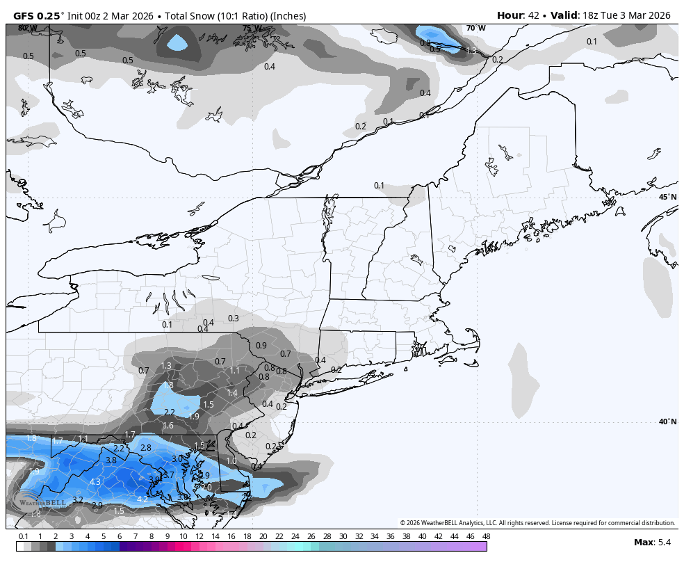
18z GFS just increased snow amounts a bit for the LSV for Tuesday am.

-
Central PA Winter 25/26 Discussion and Obs
Blizzard of 93 replied to MAG5035's topic in Upstate New York/Pennsylvania
CTP is forecasting the kitchen sink for the Harrisburg area tomorrow night into Tuesday am: Monday Night A chance of freezing rain and sleet after 1am. Increasing clouds, with a low around 27. Southeast wind 7 to 10 mph. Chance of precipitation is 50%. New sleet accumulation of less than a half inch possible. Tuesday Snow showers and freezing rain, possibly mixed with sleet before 10am, then rain or freezing rain between 10am and 1pm, then rain showers after 1pm. High near 40. Southeast wind 6 to 9 mph. Chance of precipitation is 90%. New snow and sleet accumulation of less than a half inch possible. -
Central PA Winter 25/26 Discussion and Obs
Blizzard of 93 replied to MAG5035's topic in Upstate New York/Pennsylvania
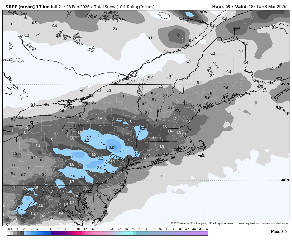
21z SREF brings the goods on Tuesday am for 1 to 2 inches across the region.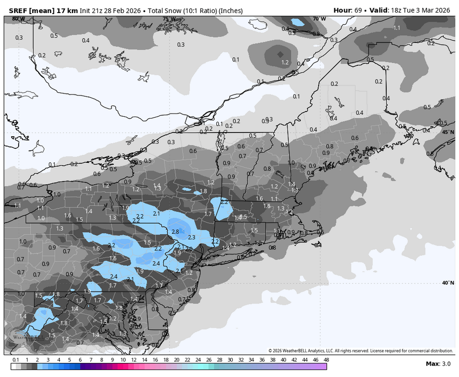
-
Outta gas and Outta Time: Early March Winter Storm finale
Blizzard of 93 replied to Ji's topic in Mid Atlantic
21z SREF brings the goods on Tuesday am for 1 to 2 inches across the region.
-
Central PA Winter 25/26 Discussion and Obs
Blizzard of 93 replied to MAG5035's topic in Upstate New York/Pennsylvania
We still have to deal with whatever Tuesday am brings before our short lived Spring break… Hazardous Weather Outlook Hazardous Weather Outlook National Weather Service State College PA 1203 PM EST Sat Feb 28 2026 PAZ024>028-033>036-056>059-063>066-011715- Cambria-Blair-Huntingdon-Mifflin-Juniata-Somerset-Bedford-Fulton- Franklin-Perry-Dauphin-Schuylkill-Lebanon-Cumberland-Adams-York- Lancaster- 1203 PM EST Sat Feb 28 2026 This Hazardous Weather Outlook is for central Pennsylvania. .DAY ONE...This afternoon and tonight. The probability of widespread hazardous weather is low. .DAYS TWO THROUGH SEVEN...Sunday through Friday. A wintry mix of snow, sleet, and freezing rain is possible on Tuesday before changing to or ending as rain. -
Outta gas and Outta Time: Early March Winter Storm finale
Blizzard of 93 replied to Ji's topic in Mid Atlantic
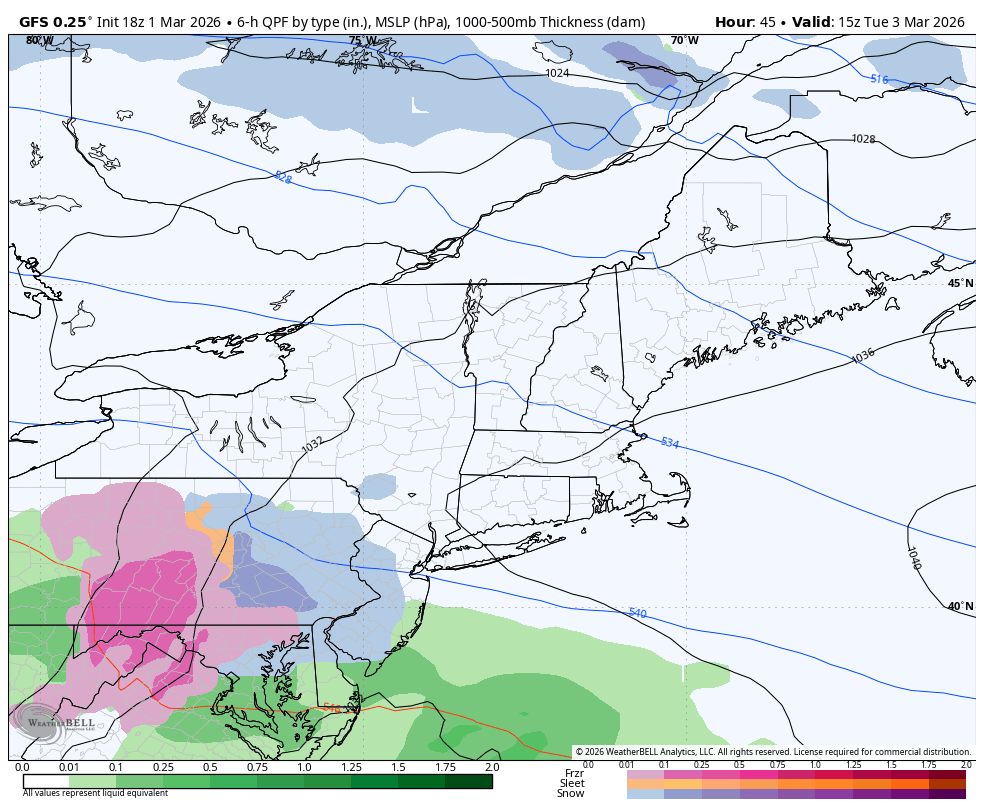
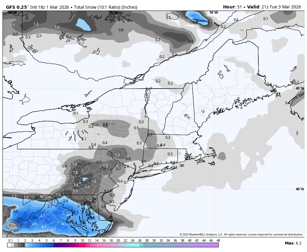
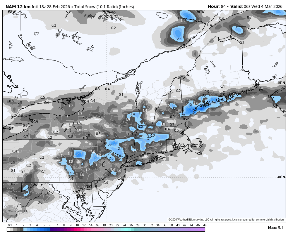
18z RGEM puts down 2 to 3 inches for many before the mix.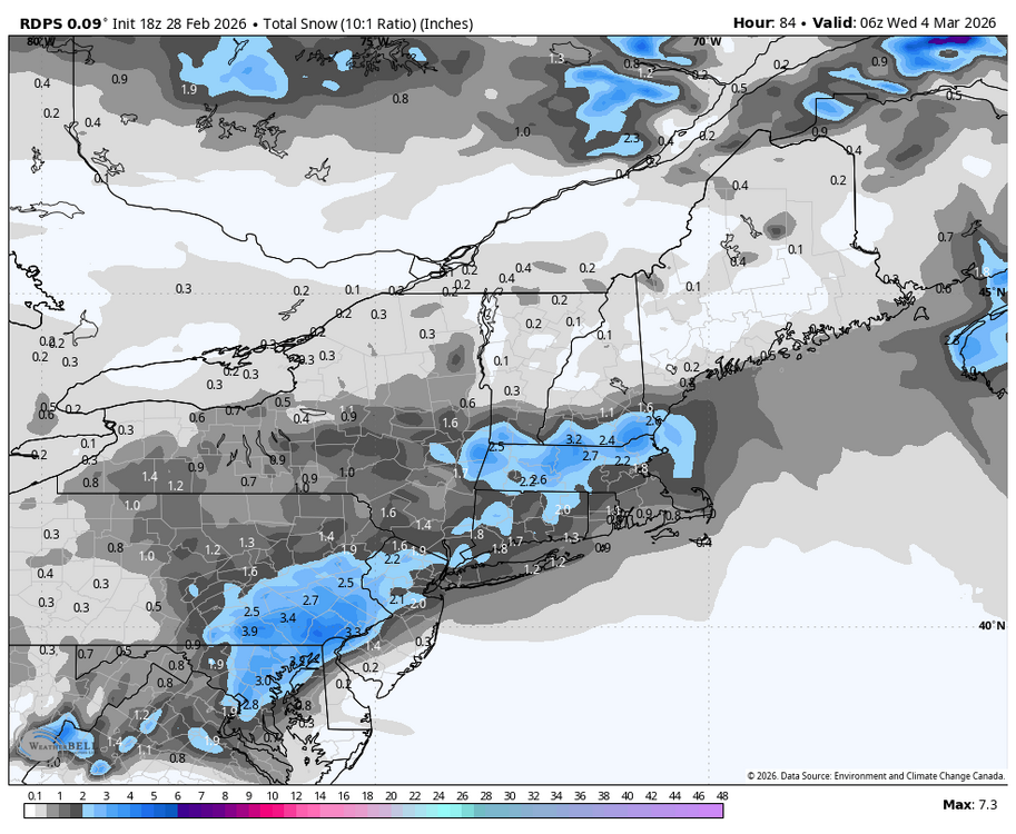
-
Central PA Winter 25/26 Discussion and Obs
Blizzard of 93 replied to MAG5035's topic in Upstate New York/Pennsylvania
18z RGEM puts down 2 to 3 inches across the LSV before the mix.
-
Central PA Winter 25/26 Discussion and Obs
Blizzard of 93 replied to MAG5035's topic in Upstate New York/Pennsylvania
18z NAM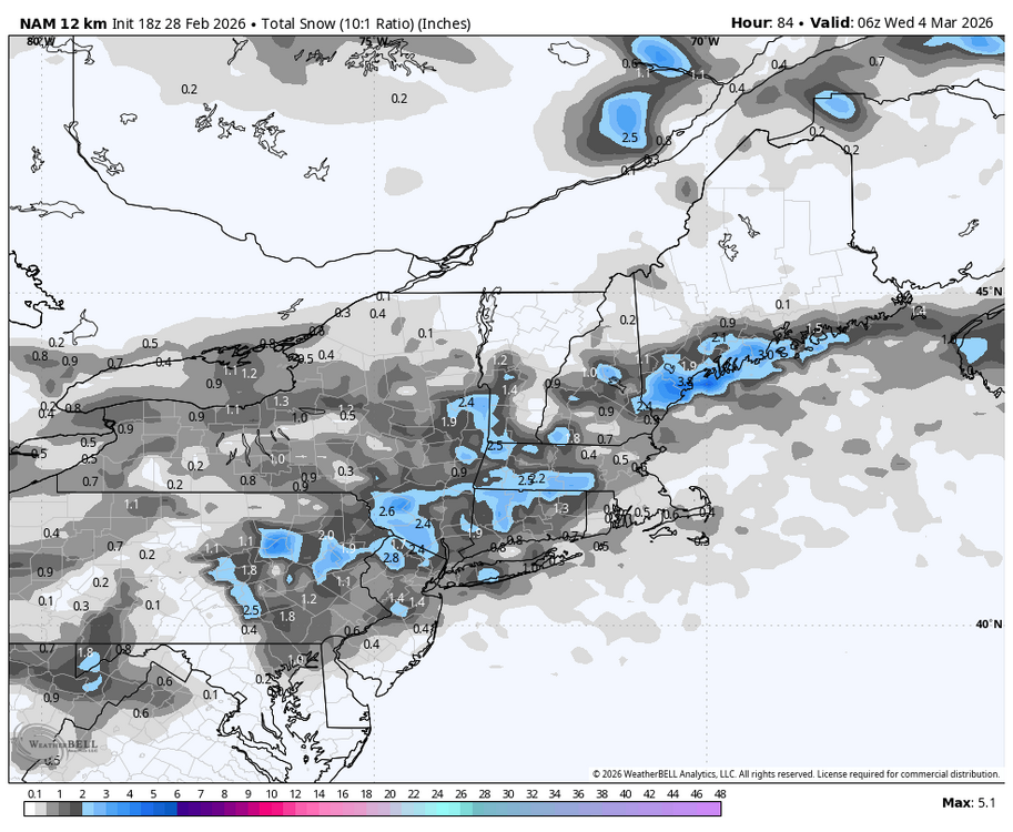
-
Central PA Winter 25/26 Discussion and Obs
Blizzard of 93 replied to MAG5035's topic in Upstate New York/Pennsylvania
Beautiful day indeed! Nice Spring preview, but it’s not going to last. Some people will be in shock with the temps the next couple of days. Short range models are showing snow to mix on Tuesday am. -
12z AI EPS is colder than the regular EPS at 360.
-
12z EPS surface temps are near normal in the east at 360.
-
Central PA Winter 25/26 Discussion and Obs
Blizzard of 93 replied to MAG5035's topic in Upstate New York/Pennsylvania
See you in mid March sir. We are not done tracking yet! -
Central PA Winter 25/26 Discussion and Obs
Blizzard of 93 replied to MAG5035's topic in Upstate New York/Pennsylvania
6z GFS at this model cycle offers our best hope for some snow early next week. It takes the first wave on Monday to our south, but it quickly brings in the second wave by Tuesday am. This second wave starts as snow & then changes over to a mix then rain. -
Central PA Winter 25/26 Discussion and Obs
Blizzard of 93 replied to MAG5035's topic in Upstate New York/Pennsylvania
Early next week will be interesting to see how it unfolds. Models today seem to be juicing up the second wave on Tuesday, but the cold may not hold enough causing snow to mix to rain depending on the timing, intensity & track. -
Central PA Winter 25/26 Discussion and Obs
Blizzard of 93 replied to MAG5035's topic in Upstate New York/Pennsylvania
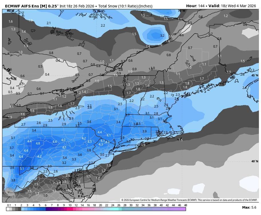
18z Euro, AI Euro, EPS & AI EPS each keep us in the game for snow chances early next week. Still lots of disagreement on strength & position of the High & the strength & latitude of the wave or waves as they approach our region.
-
Central PA Winter 25/26 Discussion and Obs
Blizzard of 93 replied to MAG5035's topic in Upstate New York/Pennsylvania
Overnight ensembles still say that we have a chance for Winter weather early next week. Ops continue to waffle back & forth. Let’s see what 12z says later on.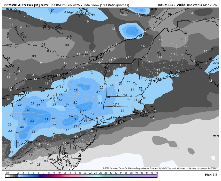
-
Central PA Winter 25/26 Discussion and Obs
Blizzard of 93 replied to MAG5035's topic in Upstate New York/Pennsylvania
MDT is at 23.8 as of today, which is 1 inch above normal for the season to date. We still have 5 realistic weeks to score more snow. Hopefully we score enough early next week to get to climo average. Then, anything after that would be gravy if we can get one more window later in March. This Winter deserves to have us at least at normal snow, so hopefully we get there. -
Central PA Winter 25/26 Discussion and Obs
Blizzard of 93 replied to MAG5035's topic in Upstate New York/Pennsylvania
Good write up from Mt. Holly on the early next week potential… However, a front will send more cold air into the region later Sunday, and hot on its heals some guidance depicts a wave of low pressure riding eastward into the region for Monday. With fresh cold air in place, more wintry weather is certainly possible. Guidance is having trouble with handling multiple pieces of energy, with some models showing multiple waves, while others focus on just one, but suffice it to say, there is a risk of wintry weather Monday and Tuesday. One notable trend in our favor is that most guidance does show a warming trend as the system moves through, such that towards mid-week we should mostly be too warm for anything but rain. We may have several inches of snow to get through before then, however. We`ll be watching this one closely for potential headlines. -
Central PA Winter 25/26 Discussion and Obs
Blizzard of 93 replied to MAG5035's topic in Upstate New York/Pennsylvania
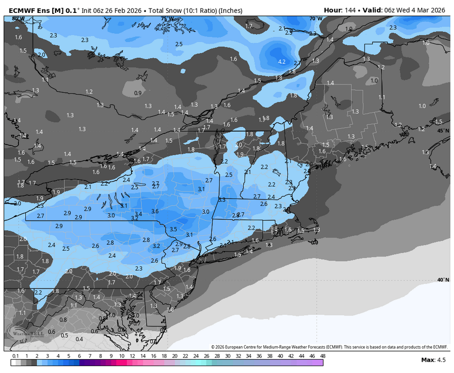
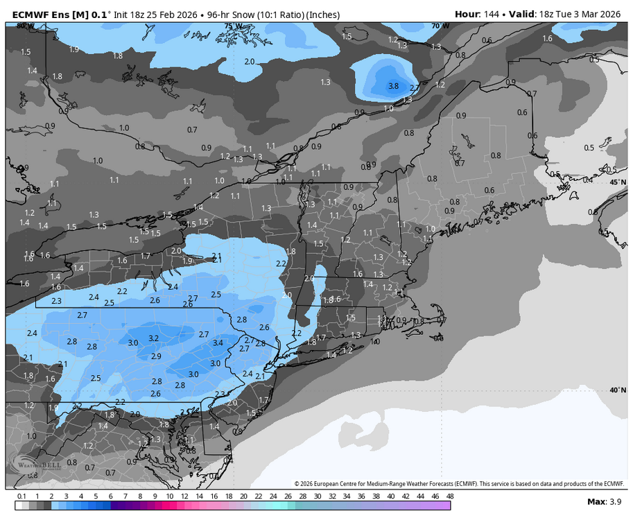
The latest 3 Major ensembles each get solid Advisory level snow to all of CTP by Tuesday afternoon. The main takeaway is that we are certainly in the game for an event chance early next week.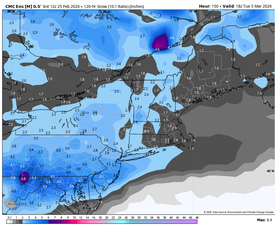
-
Central PA Winter 25/26 Discussion and Obs
Blizzard of 93 replied to MAG5035's topic in Upstate New York/Pennsylvania
Early next week still looks very interesting on the GFS & most ensembles. Timing of the cold press from the approaching High & the strength of the wave will determine if we have the chance to score meaningful snow. Hopefully this trends favorably for us.