Blizzard of 93
-
Posts
13,037 -
Joined
-
Last visited
Content Type
Profiles
Blogs
Forums
American Weather
Media Demo
Store
Gallery
Everything posted by Blizzard of 93
-
Central PA Winter 2024/2025
Blizzard of 93 replied to Voyager's topic in Upstate New York/Pennsylvania
Lol, Who cares if we get Warning level snow beforehand? -
Central PA Winter 2024/2025
Blizzard of 93 replied to Voyager's topic in Upstate New York/Pennsylvania
It’s a PA crushing! -
Central PA Winter 2024/2025
Blizzard of 93 replied to Voyager's topic in Upstate New York/Pennsylvania
I’m out to hour 27 on the HRRR & I like seeing the heavy precip in IN & west central OH. -
Central PA Winter 2024/2025
Blizzard of 93 replied to Voyager's topic in Upstate New York/Pennsylvania
I tried to find his map. @MillvilleWx can you please post your map in our thread as well when you get the chance? -
Central PA Winter 2024/2025
Blizzard of 93 replied to Voyager's topic in Upstate New York/Pennsylvania
This should be included in your next,”Day in the Life” for our forum. -
Central PA Winter 2024/2025
Blizzard of 93 replied to Voyager's topic in Upstate New York/Pennsylvania
This could be one heck of week…potentially… -
Central PA Winter 2024/2025
Blizzard of 93 replied to Voyager's topic in Upstate New York/Pennsylvania
It is a beauty that escalates quickly on the Mid Atlantic coast Next Saturday. -
Central PA Winter 2024/2025
Blizzard of 93 replied to Voyager's topic in Upstate New York/Pennsylvania
Not a bad spot to be 36 hours before local game time…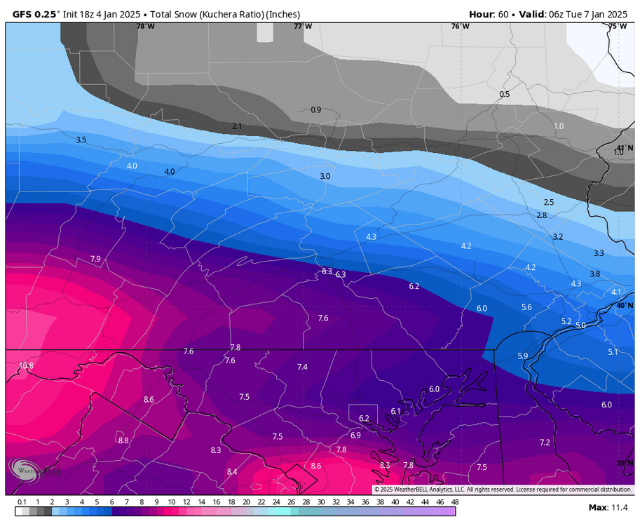
-
Central PA Winter 2024/2025
Blizzard of 93 replied to Voyager's topic in Upstate New York/Pennsylvania
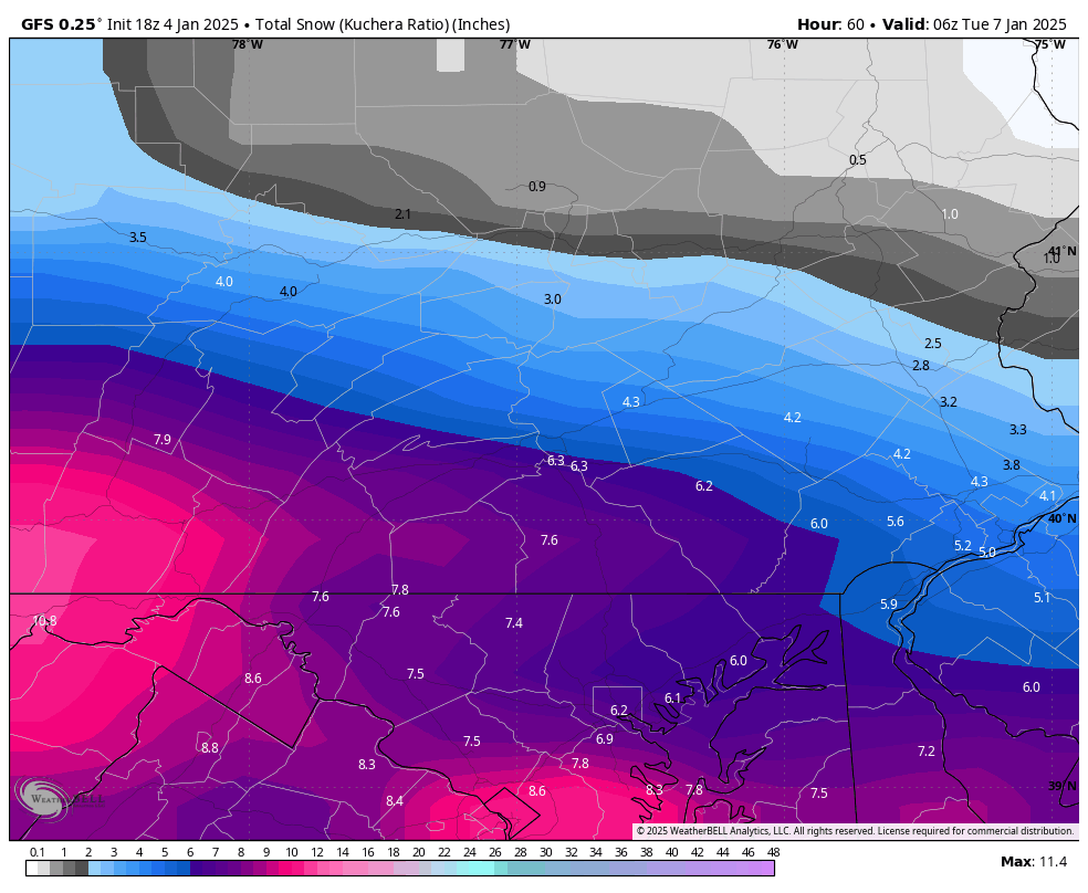
18z GFS CTP close up..:
-
Central PA Winter 2024/2025
Blizzard of 93 replied to Voyager's topic in Upstate New York/Pennsylvania
18z as @Superstorm showed us a good improvement for the LSV over 12z -
Central PA Winter 2024/2025
Blizzard of 93 replied to Voyager's topic in Upstate New York/Pennsylvania
@Voyager will also approve of it! -
Central PA Winter 2024/2025
Blizzard of 93 replied to Voyager's topic in Upstate New York/Pennsylvania
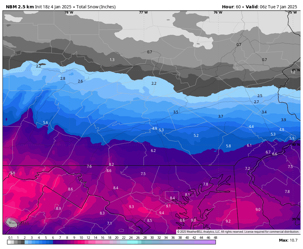
18z National Blend of models still gets Warning snow to the turnpike.
-
Central PA Winter 2024/2025
Blizzard of 93 replied to Voyager's topic in Upstate New York/Pennsylvania
I’ll approve because he barely included Marysville in the northern extent of his 4-8! -
Central PA Winter 2024/2025
Blizzard of 93 replied to Voyager's topic in Upstate New York/Pennsylvania
3k is sweet too for the LSV -
Central PA Winter 2024/2025
Blizzard of 93 replied to Voyager's topic in Upstate New York/Pennsylvania
-
Central PA Winter 2024/2025
Blizzard of 93 replied to Voyager's topic in Upstate New York/Pennsylvania
18z NAM -
Central PA Winter 2024/2025
Blizzard of 93 replied to Voyager's topic in Upstate New York/Pennsylvania
18z NAMs say game on for the LSV! -
Central PA Winter 2024/2025
Blizzard of 93 replied to Voyager's topic in Upstate New York/Pennsylvania
-
Central PA Winter 2024/2025
Blizzard of 93 replied to Voyager's topic in Upstate New York/Pennsylvania
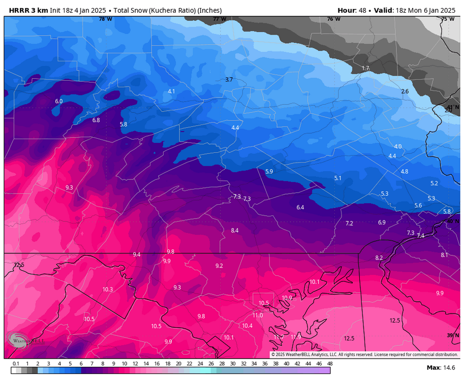
Here’s the end of the 18z HRRR at hour 48. Still a little more snow to go after this. -
Central PA Winter 2024/2025
Blizzard of 93 replied to Voyager's topic in Upstate New York/Pennsylvania
18z HRRR is NOT backing down! -
Central PA Winter 2024/2025
Blizzard of 93 replied to Voyager's topic in Upstate New York/Pennsylvania
What about the start time zig-zag map…when will that be posted? -
Central PA Winter 2024/2025
Blizzard of 93 replied to Voyager's topic in Upstate New York/Pennsylvania
Here’s another example of a north trend in December of 2020. For several days the southern half of CTP into northern MD was modeled consistently to be in the bullseye of 12 to 18. Then, a day or two before the storm, the creep north began. Some short term models started to introduce sleet to southern PA & pushed the snow jackpot out of MD/southern PA into central & NE PA. MDT ended up still getting 10 or 11 inches, but sleet mixed in for a few hours. MDT ended up on the southern end of double digit snow. I-80 to I-90 ended up getting amounts of 18-24, when they were supposed to be on the northern edge of the good amounts. My point is, there’s still some time for small changes in the grand scheme of things. -
Central PA Winter 2024/2025
Blizzard of 93 replied to Voyager's topic in Upstate New York/Pennsylvania
Remember the final event last February when MD to the southern tier of PA was supposed to get 3 to 6. North of Harrisburg was supposed to get only a couple of inches. At the last minute the storm jogged north a bit & jackpoted just north of Harrisburg out to Allentown & the southern Poconos. I ended up with 7 & Allentown got more. Small change, but drastically changed the ground truth. -
Central PA Winter 2024/2025
Blizzard of 93 replied to Voyager's topic in Upstate New York/Pennsylvania
I forgot the storm already happened…lol -
Central PA Winter 2024/2025
Blizzard of 93 replied to Voyager's topic in Upstate New York/Pennsylvania