

Blizzard of 93
-
Posts
13,037 -
Joined
-
Last visited
Content Type
Profiles
Blogs
Forums
American Weather
Media Demo
Store
Gallery
Everything posted by Blizzard of 93
-
Central PA Winter 2024/2025
Blizzard of 93 replied to Voyager's topic in Upstate New York/Pennsylvania
Penn State is playing a great first half. -
Central PA Winter 2024/2025
Blizzard of 93 replied to Voyager's topic in Upstate New York/Pennsylvania
Back to the weather, here’s the 0z HRRR for Saturday am. -
Central PA Winter 2024/2025
Blizzard of 93 replied to Voyager's topic in Upstate New York/Pennsylvania
I really don’t like the anti Catholic slander on here today whatsoever. As a practicing Catholic who went to Catholic school including college, I find these comments to be offensive. -
Central PA Winter 2024/2025
Blizzard of 93 replied to Voyager's topic in Upstate New York/Pennsylvania
I understand! That’s how I get during Eagles games & Phillies playoff games. -
Central PA Winter 2024/2025
Blizzard of 93 replied to Voyager's topic in Upstate New York/Pennsylvania
It’s now casting & HRRR & NAM time. -
Central PA Winter 2024/2025
Blizzard of 93 replied to Voyager's topic in Upstate New York/Pennsylvania
I’ve been staring at this map all week trying to understand why this isn’t delivering at least a low end Warning event, but the streams don’t want to interact properly or get out of each other’s way unfortunately. -
Central PA Winter 2024/2025
Blizzard of 93 replied to Voyager's topic in Upstate New York/Pennsylvania
6z NAMs improved just a bit for the light event Saturday am. -
Central PA Winter 2024/2025
Blizzard of 93 replied to Voyager's topic in Upstate New York/Pennsylvania
Agreed, there is a decent amount of moisture available if the 2 streams can play together nicely or at least not fight each other off. -
Central PA Winter 2024/2025
Blizzard of 93 replied to Voyager's topic in Upstate New York/Pennsylvania
There would still be a little more to go if the run went past 60 hours. -
Central PA Winter 2024/2025
Blizzard of 93 replied to Voyager's topic in Upstate New York/Pennsylvania
The 3k NAM is slightly more interesting for the Saturday am light event. -
Central PA Winter 2024/2025
Blizzard of 93 replied to Voyager's topic in Upstate New York/Pennsylvania
@Itstrainingtime It looks like @psuhoffman agrees with your assessment from yesterday, Lol! -
Central PA Winter 2024/2025
Blizzard of 93 replied to Voyager's topic in Upstate New York/Pennsylvania
Someone in another thread earlier mentioned that these light nickel & dime events can help to make a difference in the seasonal snow total. These 1.2 & .3 & .8 type of events can add up if you get several of them in a season. Last season, MDT had 5 moderate events that added up to 18 inches. What was missing were the nickel & dime events that could have allowed the seasonal total to be more respectable. My point is that I’m ok with the nickels & dimes as long as we get some meaningful storms along the way. -
Central PA Winter 2024/2025
Blizzard of 93 replied to Voyager's topic in Upstate New York/Pennsylvania
Back to the Saturday light event, here’s the 18z Euro. -
Central PA Winter 2024/2025
Blizzard of 93 replied to Voyager's topic in Upstate New York/Pennsylvania
I understand the frustration, but our prime snow climo is mid January to mid February. -
Central PA Winter 2024/2025
Blizzard of 93 replied to Voyager's topic in Upstate New York/Pennsylvania
More good news from the Mid Atlantic thread. This afternoon @Bob Chill & @psuhoffman were commenting that the upcoming advertised pattern has similarities to the good Winters of 2014 & 2015. -
Central PA Winter 2024/2025
Blizzard of 93 replied to Voyager's topic in Upstate New York/Pennsylvania
@mitchnick in the main thread commented in the last couple of hours that the latest Euro Weeklies lock in the gold through late January. The warm up in early February also looks muted according to the Weeklies. -
Central PA Winter 2024/2025
Blizzard of 93 replied to Voyager's topic in Upstate New York/Pennsylvania
We just missed a 6 to 10 inch snowstorm by less than 100 miles to the SOUTH of southern PA… But yes, it’s obviously over… What a joke -
Central PA Winter 2024/2025
Blizzard of 93 replied to Voyager's topic in Upstate New York/Pennsylvania
Super obvious on January 7th, Lol! We still have 3 months to score snow. The cold is entrenched, it’s just a matter of time until we get good snow. -
Central PA Winter 2024/2025
Blizzard of 93 replied to Voyager's topic in Upstate New York/Pennsylvania
The Friday night in Saturday storm looks like a light event at this point for us. Here are the 6z GFS & Euro. -
Central PA Winter 2024/2025
Blizzard of 93 replied to Voyager's topic in Upstate New York/Pennsylvania
Our prime climo for snow is mid January to mid February. Long way to go… -
Central PA Winter 2024/2025
Blizzard of 93 replied to Voyager's topic in Upstate New York/Pennsylvania
Lol, it’s January 7th for goodness sake! -
Central PA Winter 2024/2025
Blizzard of 93 replied to Voyager's topic in Upstate New York/Pennsylvania
I think some of them were hoping that those few massive HECS runs from a few days ago would come to fruition. Now that it’s likely at best to be a possible light to moderate event, some have lost interest in the neighboring sub forums. If they temper expectations, this Friday night into Saturday could reasonably end up producing a solid Advisory event, even possibly for us in the LSV. -
Central PA Winter 2024/2025
Blizzard of 93 replied to Voyager's topic in Upstate New York/Pennsylvania
I thought of you when I needed to retrieve my recycling bin this evening when the wind made it wander down the block. -
Central PA Winter 2024/2025
Blizzard of 93 replied to Voyager's topic in Upstate New York/Pennsylvania
We have also seen these type of systems go either way over the years. The low could slide further east & miss us. But, it could also juice up just a bit & deliver a 3 to 6 or so type of event with a decent track.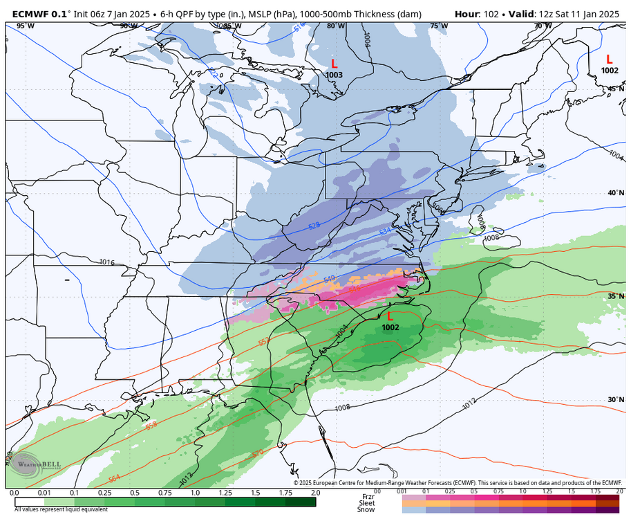
-
Central PA Winter 2024/2025
Blizzard of 93 replied to Voyager's topic in Upstate New York/Pennsylvania
I would mind to keep stacking light to moderate events as we wait for a flush hit of hopefully at some point this month.


