Blizzard of 93
-
Posts
13,037 -
Joined
-
Last visited
Content Type
Profiles
Blogs
Forums
American Weather
Media Demo
Store
Gallery
Everything posted by Blizzard of 93
-
Central PA Winter 2024/2025
Blizzard of 93 replied to Voyager's topic in Upstate New York/Pennsylvania
Winter Weather Advisory URGENT - WINTER WEATHER MESSAGE National Weather Service State College PA 157 PM EST Sun Jan 5 2025 PAZ056-057-059-063-060915- /O.CON.KCTP.WW.Y.0002.250106T0500Z-250107T0500Z/ Perry-Dauphin-Lebanon-Cumberland- Including the cities of Newport, Lebanon, Harrisburg, Hershey, and Carlisle 157 PM EST Sun Jan 5 2025 ...WINTER WEATHER ADVISORY REMAINS IN EFFECT FROM MIDNIGHT TONIGHT TO MIDNIGHT EST MONDAY NIGHT... * WHAT...Snow expected. Total snow accumulations between 2 and 4 inches. * WHERE...Cumberland, Dauphin, Lebanon, and Perry Counties. * WHEN...From midnight tonight to midnight EST Monday Night. * IMPACTS...Plan on slippery road conditions. The hazardous conditions could impact the Monday morning and evening commutes. -
Central PA Winter 2024/2025
Blizzard of 93 replied to Voyager's topic in Upstate New York/Pennsylvania
Nope, the Winter weather advisory is 2 to 4. -
Central PA Winter 2024/2025
Blizzard of 93 replied to Voyager's topic in Upstate New York/Pennsylvania
You mean this little old 972 low just off of the DelMarVa next weekend? -
Central PA Winter 2024/2025
Blizzard of 93 replied to Voyager's topic in Upstate New York/Pennsylvania
It is a great feeling in the rare cases when an Advisory gets updated to a Warning in the middle of a storm. -
Central PA Winter 2024/2025
Blizzard of 93 replied to Voyager's topic in Upstate New York/Pennsylvania
3k NAM brings the purples back over the MD line.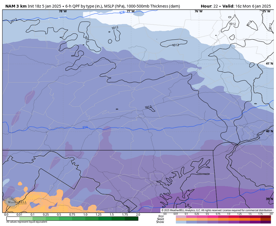
-
Central PA Winter 2024/2025
Blizzard of 93 replied to Voyager's topic in Upstate New York/Pennsylvania
Yes, get in the precip shield & see where the banding sets up. -
Central PA Winter 2024/2025
Blizzard of 93 replied to Voyager's topic in Upstate New York/Pennsylvania
18z HRRR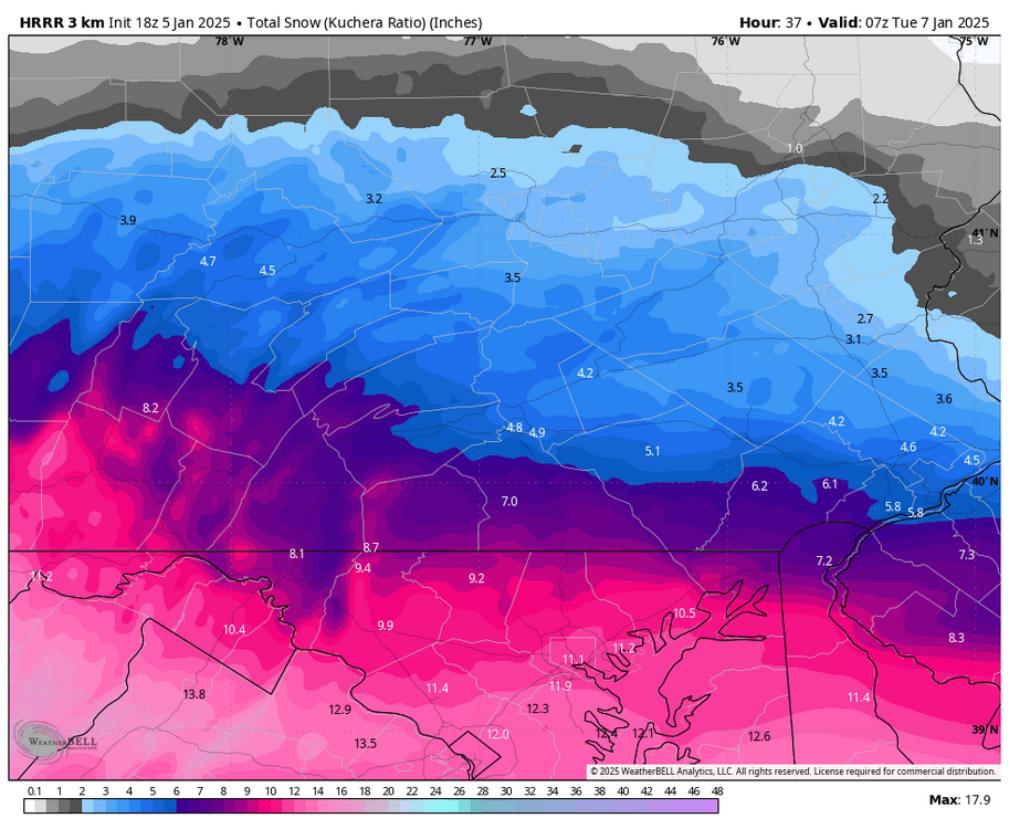
-
Central PA Winter 2024/2025
Blizzard of 93 replied to Voyager's topic in Upstate New York/Pennsylvania
We don’t need much of a bump to get back into a little bit better of the goods for the LSV. -
Central PA Winter 2024/2025
Blizzard of 93 replied to Voyager's topic in Upstate New York/Pennsylvania
Here’s another view 12z GFS Kuchera. its about .5 more snow in the LSV over its 6z run. -
Central PA Winter 2024/2025
Blizzard of 93 replied to Voyager's topic in Upstate New York/Pennsylvania
But I was told to put a fork in it? Not you -
Central PA Winter 2024/2025
Blizzard of 93 replied to Voyager's topic in Upstate New York/Pennsylvania
Yes indeed! -
Central PA Winter 2024/2025
Blizzard of 93 replied to Voyager's topic in Upstate New York/Pennsylvania
Plus, we aren’t getting shut out, we just aren’t in the bullseye. -
Central PA Winter 2024/2025
Blizzard of 93 replied to Voyager's topic in Upstate New York/Pennsylvania
Not even remotely close to that pain. That was a historic storm. This is a good storm, but much more ordinary. -
Central PA Winter 2024/2025
Blizzard of 93 replied to Voyager's topic in Upstate New York/Pennsylvania
I like it, but how much for Marysville & Philly, Lol! -
Central PA Winter 2024/2025
Blizzard of 93 replied to Voyager's topic in Upstate New York/Pennsylvania
Good morning everyone. Here’s the 9z National Blend of Models -
Central PA Winter 2024/2025
Blizzard of 93 replied to Voyager's topic in Upstate New York/Pennsylvania
0z GFS is pretty similar to its 18z run. Warning level snow up to around the turnpike.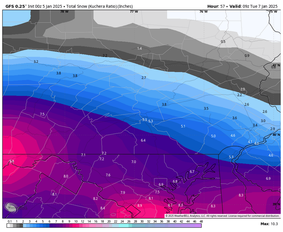
-
Central PA Winter 2024/2025
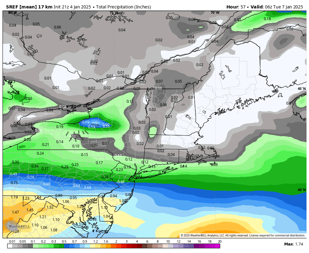
Blizzard of 93 replied to Voyager's topic in Upstate New York/Pennsylvania
Even though the 21z SREF is likely overdone, it is an impressive amount of precip for the LSV. This snow map is 10-1, so Kuchera would be even more. I would be happy with less, but this high end potential would be something.
-
Central PA Winter 2024/2025
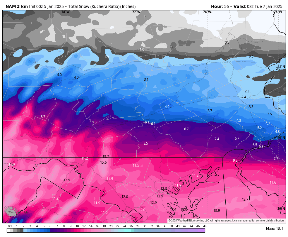
Blizzard of 93 replied to Voyager's topic in Upstate New York/Pennsylvania
Good to see the Hi Res NAM delivering the goods at 0z got the LSV.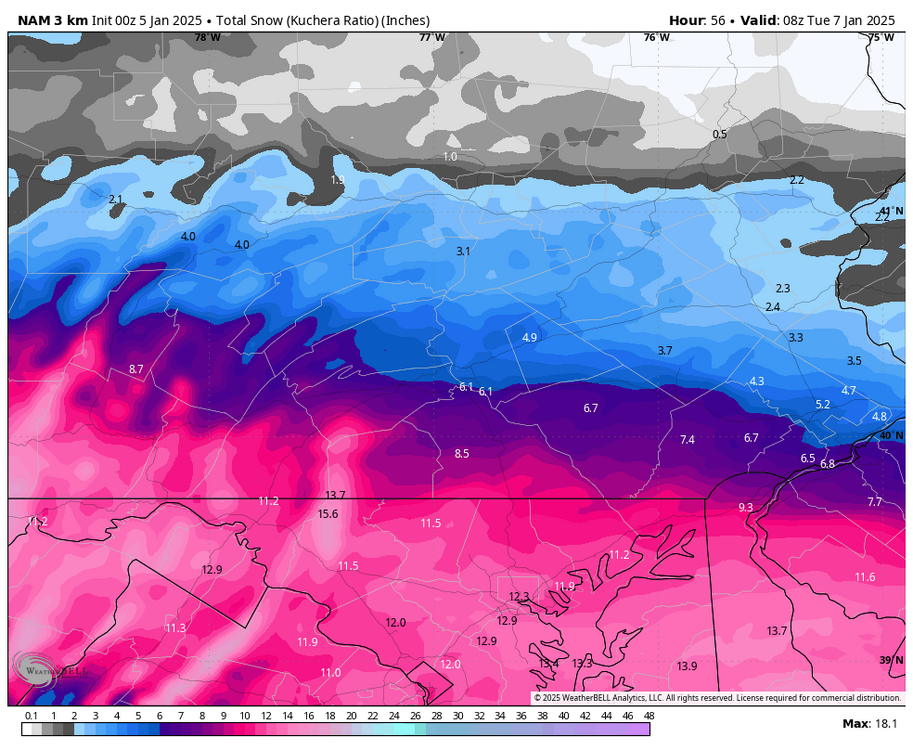
-
Central PA Winter 2024/2025
Blizzard of 93 replied to Voyager's topic in Upstate New York/Pennsylvania
-
Central PA Winter 2024/2025
Blizzard of 93 replied to Voyager's topic in Upstate New York/Pennsylvania
3k NAM is MUCH better than the 12k… -
Central PA Winter 2024/2025
Blizzard of 93 replied to Voyager's topic in Upstate New York/Pennsylvania
I’ll be thrilled if it is half right for the Harrisburg area. -
Central PA Winter 2024/2025
Blizzard of 93 replied to Voyager's topic in Upstate New York/Pennsylvania
Hopefully the NAMs are in the same ballpark as the HRRR. -
Central PA Winter 2024/2025
Blizzard of 93 replied to Voyager's topic in Upstate New York/Pennsylvania
Me too, I couldn’t wait… -
Central PA Winter 2024/2025
Blizzard of 93 replied to Voyager's topic in Upstate New York/Pennsylvania
I’ll settle for a partial compromise. -
Central PA Winter 2024/2025
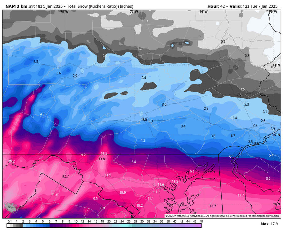
Blizzard of 93 replied to Voyager's topic in Upstate New York/Pennsylvania
The snow map is glorious already & still ongoing