Blizzard of 93
-
Posts
13,037 -
Joined
-
Last visited
Content Type
Profiles
Blogs
Forums
American Weather
Media Demo
Store
Gallery
Everything posted by Blizzard of 93
-
Central PA Winter 2024/2025
Blizzard of 93 replied to Voyager's topic in Upstate New York/Pennsylvania
Good news is that the 12z Euro appears to be on board for an event next weekend. -
Central PA Winter 2024/2025
Blizzard of 93 replied to Voyager's topic in Upstate New York/Pennsylvania
12z Euro still won’t budge… -
Central PA Winter 2024/2025
Blizzard of 93 replied to Voyager's topic in Upstate New York/Pennsylvania
Not wishing… NAMs & some other short range guidance are on board for LSV Warning snow. Also there are dozens of times over the years… including last year, when storms track a little further north at game time. We are not trying to “will” it up here from southern VA… It won’t take much for a slight bump north. I don’t think the LSV gets the bullseye, but I could see solid low end Warning numbers with a small shift. -
Central PA Winter 2024/2025
Blizzard of 93 replied to Voyager's topic in Upstate New York/Pennsylvania
For next weekend, the 12z GFS has a major coastal this run. Snow map is drool worthy for next weekend… -
Central PA Winter 2024/2025
Blizzard of 93 replied to Voyager's topic in Upstate New York/Pennsylvania
Good…good, I was worried when just Yesterday you said 5 to 8… We need you down playing more for us to score. This has a good track record over the years on here… -
Central PA Winter 2024/2025
Blizzard of 93 replied to Voyager's topic in Upstate New York/Pennsylvania
Plenty of time to get a small bump north to get the LSV into the better goods like the NAM is showing. The actual storm is just going to emerge from the Rockies later today. We can still get an incremental bump north. -
Central PA Winter 2024/2025
Blizzard of 93 replied to Voyager's topic in Upstate New York/Pennsylvania
GFS run is acceptable to me for the LSV.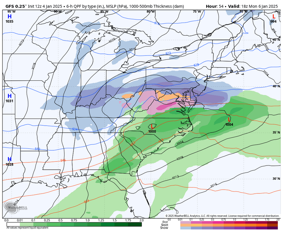
-
Central PA Winter 2024/2025
Blizzard of 93 replied to Voyager's topic in Upstate New York/Pennsylvania
3k NAM 12z still with Warning LSV snow. -
Central PA Winter 2024/2025
Blizzard of 93 replied to Voyager's topic in Upstate New York/Pennsylvania
I would sign for .5 to .7 of precip in the LSV with good ratios. -
Central PA Winter 2024/2025
Blizzard of 93 replied to Voyager's topic in Upstate New York/Pennsylvania
-
Central PA Winter 2024/2025
Blizzard of 93 replied to Voyager's topic in Upstate New York/Pennsylvania
Improvement for Harrisburg & Lancaster at 12z run vs. 6z. -
Central PA Winter 2024/2025
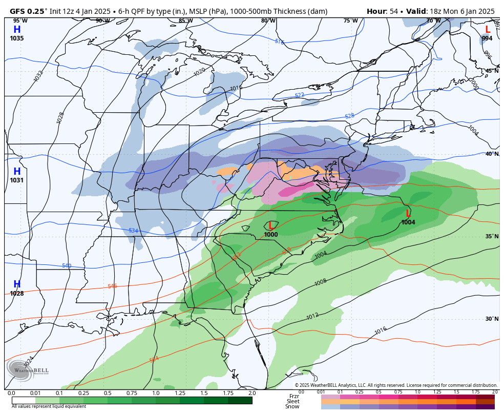
Blizzard of 93 replied to Voyager's topic in Upstate New York/Pennsylvania
12z NAM hour 54 -
Central PA Winter 2024/2025
Blizzard of 93 replied to Voyager's topic in Upstate New York/Pennsylvania
-
Central PA Winter 2024/2025
Blizzard of 93 replied to Voyager's topic in Upstate New York/Pennsylvania
12z NAMing appears to be underway in southern PA at hour 48… -
Central PA Winter 2024/2025
Blizzard of 93 replied to Voyager's topic in Upstate New York/Pennsylvania
12z National Blend of models ticked slightly better for the LSV. -
Central PA Winter 2024/2025
Blizzard of 93 replied to Voyager's topic in Upstate New York/Pennsylvania
Why not a third view of the 12z HRRR ? I like seeing that low in eastern Kentucky. -
Central PA Winter 2024/2025
Blizzard of 93 replied to Voyager's topic in Upstate New York/Pennsylvania
The National Blend of Models also gets Warning snow to Harrisburg. -
Central PA Winter 2024/2025
Blizzard of 93 replied to Voyager's topic in Upstate New York/Pennsylvania
Speaking of the SREF. The latest SREF mean would be acceptable for the southern third. -
Central PA Winter 2024/2025
Blizzard of 93 replied to Voyager's topic in Upstate New York/Pennsylvania
The 3k NAM depiction of the precip shield is what you typically see in the southern half of PA when a low is in Eastern Tennessee & western NC. -
Central PA Winter 2024/2025
Blizzard of 93 replied to Voyager's topic in Upstate New York/Pennsylvania
The 3k NAM looks very good with for the southern half of PA. The run ends at 60 hours, with more snow to go. Hopefully more short range guidance trends this direction as we approach game time. -
Central PA Winter 2024/2025
Blizzard of 93 replied to Voyager's topic in Upstate New York/Pennsylvania
Good to see the 6z NAM with the Warning level snow up to Harrisburg this run. -
Central PA Winter 2024/2025
Blizzard of 93 replied to Voyager's topic in Upstate New York/Pennsylvania
Here are the 6z Euro & 6z GFS. The goalposts seem to be narrowing. Hopefully by tonight we start to see the small bumps back a little north to get more of the southern half of PA into the better snow. -
Central PA Winter 2024/2025
Blizzard of 93 replied to Voyager's topic in Upstate New York/Pennsylvania
I’ve never seen them use broad ranges like 3 to 8. -
Central PA Winter 2024/2025
Blizzard of 93 replied to Voyager's topic in Upstate New York/Pennsylvania
Sorry, I was so excited to see his map that I didn’t fully read the post, Lol! I need coffee. -
Central PA Winter 2024/2025
Blizzard of 93 replied to Voyager's topic in Upstate New York/Pennsylvania
Good morning, I can’t see his map with that link.