Blizzard of 93
-
Posts
13,037 -
Joined
-
Last visited
Content Type
Profiles
Blogs
Forums
American Weather
Media Demo
Store
Gallery
Everything posted by Blizzard of 93
-
Central PA Winter 2024/2025
Blizzard of 93 replied to Voyager's topic in Upstate New York/Pennsylvania
I see what you mean with the 6z GEFS & 6z EPS getting the LSV into the main area of precip. We are very much in the game.

-
Central PA Winter 2024/2025
Blizzard of 93 replied to Voyager's topic in Upstate New York/Pennsylvania
Happy New Year!!! -
Central PA Winter 2024/2025
Blizzard of 93 replied to Voyager's topic in Upstate New York/Pennsylvania
Unbelievable, wow! Let’s see what the Euro says soon. -
January: Medium/ Long Range: May the Force be with Us....
Blizzard of 93 replied to Weather Will's topic in Mid Atlantic
Tell us more… -
Central PA Winter 2024/2025
Blizzard of 93 replied to Voyager's topic in Upstate New York/Pennsylvania
Hopefully the Euro does the same -
Central PA Winter 2024/2025
Blizzard of 93 replied to Voyager's topic in Upstate New York/Pennsylvania
Again, LFG!!! -
Central PA Winter 2024/2025
Blizzard of 93 replied to Voyager's topic in Upstate New York/Pennsylvania
LFG !!! -
Central PA Winter 2024/2025
Blizzard of 93 replied to Voyager's topic in Upstate New York/Pennsylvania
Tough crowd, I would have thought PSU was down by 20 points… Lol, go State?! -
Central PA Winter 2024/2025
Blizzard of 93 replied to Voyager's topic in Upstate New York/Pennsylvania
Despite the torch the last 2 days, MDT is holding on to a -1.6 degree departure for the month. So even when today’s above normal day is factored in, MDT will have another below normal temperature month. -
Central PA Winter 2024/2025
Blizzard of 93 replied to Voyager's topic in Upstate New York/Pennsylvania
The EPS still has a decent middle ground & puts us very much in the game.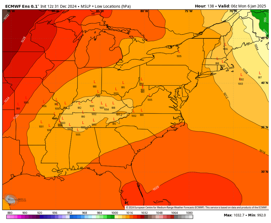

-
Central PA Winter 2024/2025
Blizzard of 93 replied to Voyager's topic in Upstate New York/Pennsylvania
Someone just posted the recent official model rankings a couple of days ago in the Mid Atlantic thread. The Euro was first & the GFS was near the bottom, worse than the Canadian. -
Central PA Winter 2024/2025
Blizzard of 93 replied to Voyager's topic in Upstate New York/Pennsylvania
Good points. It’s not like we are trying to will a Miller A with precip cutting off in southern VA to move up to our latitude. Most guidance has a juicy low tracking from the Tennessee Valley into the lower Ohio Valley with an established juicy precip field. I will take my chances in southern PA with this set up. -
Central PA Winter 2024/2025
Blizzard of 93 replied to Voyager's topic in Upstate New York/Pennsylvania
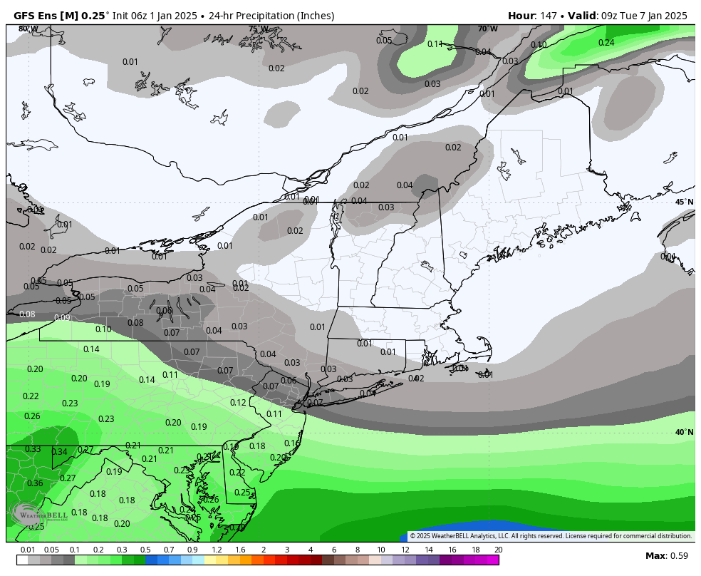
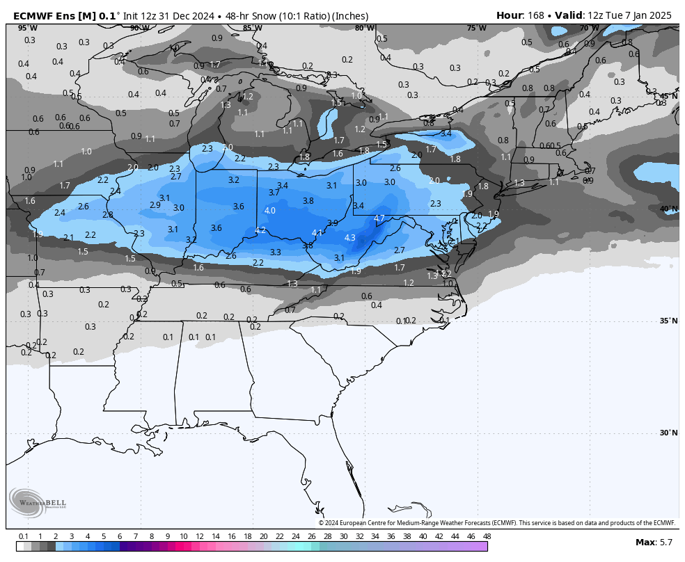
12z runs leave all options on the table from good snow hits from the ICON & Ukie, to light snow from the Euro to whiff from the GFS. On to 18z… -
Central PA Winter 2024/2025
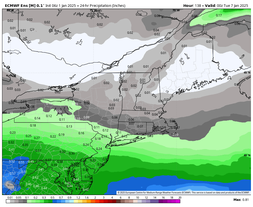
Blizzard of 93 replied to Voyager's topic in Upstate New York/Pennsylvania
Unfortunately the Euro this run hits a wall & takes the best snow into VA & DC this run. Still not a bad spot to be 5 or 6 days out. -
Central PA Winter 2024/2025
Blizzard of 93 replied to Voyager's topic in Upstate New York/Pennsylvania
Lol, no need to apologize, but do you have the Ukie Kuchera map? -
Central PA Winter 2024/2025
Blizzard of 93 replied to Voyager's topic in Upstate New York/Pennsylvania
Here’s another Ukie map I ripped from another thread. Still 10-1, but zoomed in & for the whole event. -
Central PA Winter 2024/2025
Blizzard of 93 replied to Voyager's topic in Upstate New York/Pennsylvania
@mitchnick is busy in the other thread, but I just stole this 12z Ukie from them. I would like to see a more zoomed in Kuchera for the whole event if someone has it. WB doesn’t have good Ukie maps… -
Central PA Winter 2024/2025
Blizzard of 93 replied to Voyager's topic in Upstate New York/Pennsylvania
@mitchnick Please post the Ukie for us! -
Central PA Winter 2024/2025
Blizzard of 93 replied to Voyager's topic in Upstate New York/Pennsylvania
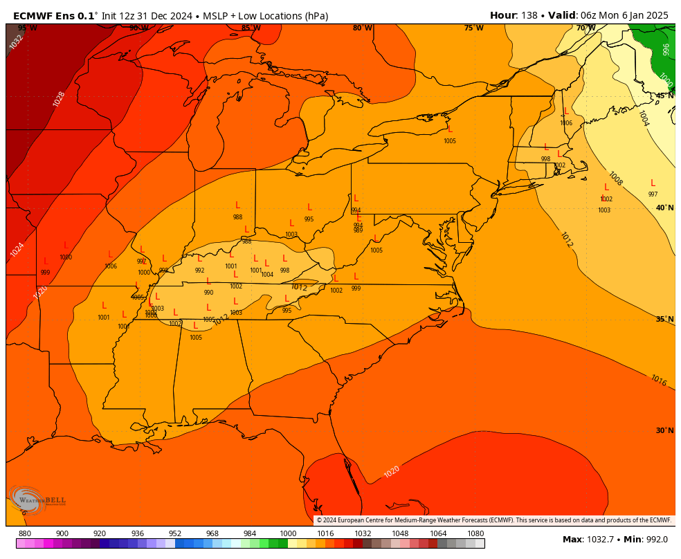
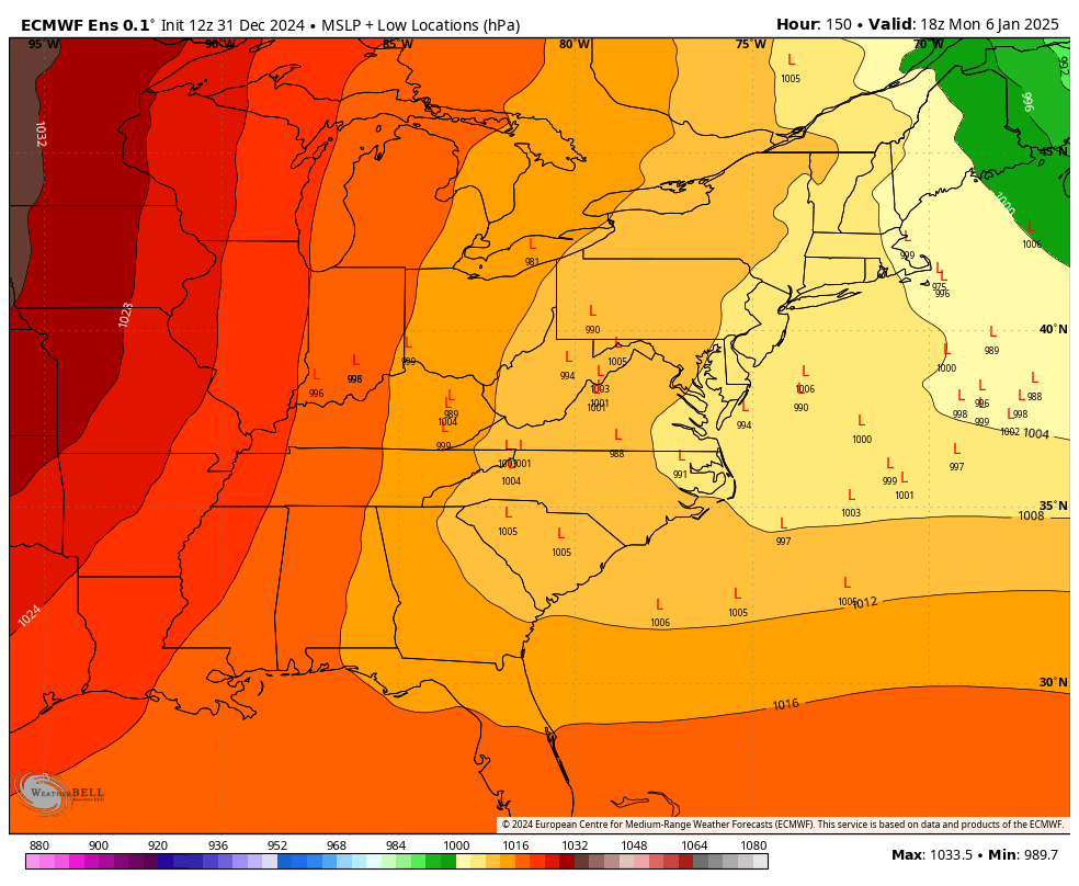
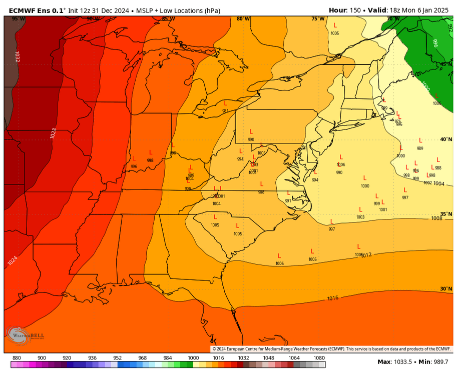
Indeed, still 6 days to go. I like that the cutter idea is fading, but now we need to avoid suppression. Over the years, lows that track to Kentucky & fade or jump to the VA Capes, usually bring the main swath of precip into at least the southern half of PA. -
Central PA Winter 2024/2025
Blizzard of 93 replied to Voyager's topic in Upstate New York/Pennsylvania
The Canadian still shears out at the last minute, but I like the look it had with the low in Southwest Kentucky and the associated precip position. Ease that confluence just a bit & it would work well for southern PA. -
Central PA Winter 2024/2025
Blizzard of 93 replied to Voyager's topic in Upstate New York/Pennsylvania
The Canadian is rolling & so far looks more amped like the ICON & Euro. -
Central PA Winter 2024/2025
Blizzard of 93 replied to Voyager's topic in Upstate New York/Pennsylvania
Good start to 12z! -
Central PA Winter 2024/2025
Blizzard of 93 replied to Voyager's topic in Upstate New York/Pennsylvania
Can you please post his thoughts when you get the chance? I tried to find it on their twitter page & website, but didn’t see anything today about the next week possibilities. -
Central PA Winter 2024/2025
Blizzard of 93 replied to Voyager's topic in Upstate New York/Pennsylvania
It was good to see the overnight model runs bring back the end of next week chance of a coastal possibly on the 10th & 11th. All options are on the table, hopefully we cash in at least once. Lots of tracking fun & games ahead. -
Central PA Winter 2024/2025
Blizzard of 93 replied to Voyager's topic in Upstate New York/Pennsylvania
That’s music to my ears! Good to hear that he is possibly on board.