Blizzard of 93
-
Posts
13,037 -
Joined
-
Last visited
Content Type
Profiles
Blogs
Forums
American Weather
Media Demo
Store
Gallery
Everything posted by Blizzard of 93
-
Central PA Winter 2024/2025
Blizzard of 93 replied to Voyager's topic in Upstate New York/Pennsylvania
This is the point & click for Harrisburg for tomorrow’s Clipper. Thursday Light snow, mainly after 11am. High near 30. Calm wind becoming south 5 to 8 mph in the morning. Chance of precipitation is 80%. New snow accumulation of around an inch possible. -
Central PA Winter 2024/2025
Blizzard of 93 replied to Voyager's topic in Upstate New York/Pennsylvania
First things first, the 18z Euro is still on board for a coating to an inch in the LSV tomorrow with the Clipper. -
Central PA Winter 2024/2025
Blizzard of 93 replied to Voyager's topic in Upstate New York/Pennsylvania
JB had a good post today on the potential Sunday event. He said the Canadian is developing the wave in the Arctic front, while the GFS is just jumping out to the boundary further east. He thinks the answer will likely end up in between, with a solution like the Euro AI has been showing. The Euro AI has been fairly consistent with the Sunday chance. I like where the LSV sits for an Advisory level event on Sunday. -
Central PA Winter 2024/2025
Blizzard of 93 replied to Voyager's topic in Upstate New York/Pennsylvania
Good thing I went to sleep. Models are all over the place for Sunday & next week’s possibility. On to 12z… -
Central PA Winter 2024/2025
Blizzard of 93 replied to Voyager's topic in Upstate New York/Pennsylvania
Good to see all 0z models except the GFS on board for Sunday so far. -
Central PA Winter 2024/2025
Blizzard of 93 replied to Voyager's topic in Upstate New York/Pennsylvania
Lol, you’re correct sir, but we need to sleep sometime. I really shouldn’t stay up for the Euro tonight… It’s going to be a long week. -
Central PA Winter 2024/2025
Blizzard of 93 replied to Voyager's topic in Upstate New York/Pennsylvania
Please, please, please give us this entire Canadian run… -
Central PA Winter 2024/2025
Blizzard of 93 replied to Voyager's topic in Upstate New York/Pennsylvania
Give me this 0z Canadian run for Sunday… -
Central PA Winter 2024/2025
Blizzard of 93 replied to Voyager's topic in Upstate New York/Pennsylvania
I just noticed that the 0z NAM twins juiced up the Clipper for Thursday pm for especially Harrisburg & Lancaster. -
Central PA Winter 2024/2025
Blizzard of 93 replied to Voyager's topic in Upstate New York/Pennsylvania
Good start to 0z. -
Central PA Winter 2024/2025
Blizzard of 93 replied to Voyager's topic in Upstate New York/Pennsylvania
We have 2 short term opportunities for snow with the Clipper on Thursday & the Sunday pm Advisory level possibility. I know that you can’t shovel potential… but to me, it’s only a matter of time until we get a flush snow hit. Cold air is not the issue this year. We just need the proper timing with some moisture. The 12z Euro for next week would be perfectly acceptable, Lol! -
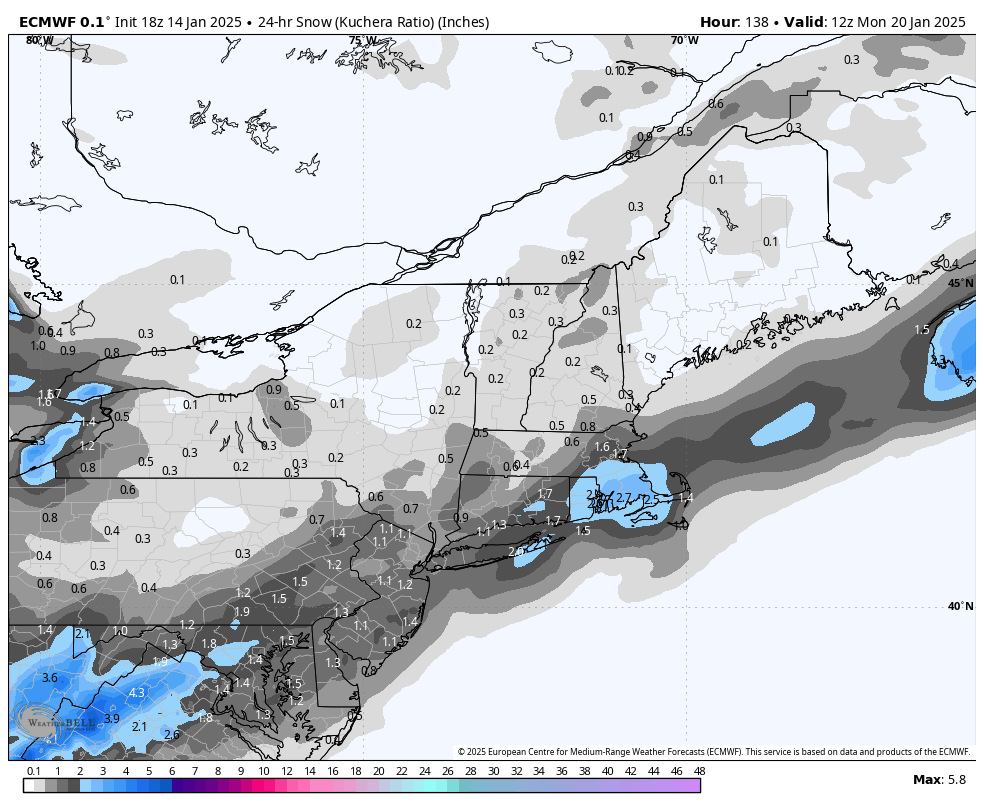
January Medium/Long Range: A snowy January ahead?
Blizzard of 93 replied to mappy's topic in Mid Atlantic
Here’s the 18z Euro Kuchera for just the Sunday pm chance.
-
Central PA Winter 2024/2025
Blizzard of 93 replied to Voyager's topic in Upstate New York/Pennsylvania
The 6z Euro has a potential lAdvisory level event on Sunday evening for most of CTP this run. -
January Medium/Long Range: A snowy January ahead?
Blizzard of 93 replied to mappy's topic in Mid Atlantic
Lol, the models still can’t agree on the potential Sunday night into Monday possibility, but some of you guys are depressed about what might happen after the undecided prior period? On to 12z… -
January Medium/Long Range: A snowy January ahead?
Blizzard of 93 replied to mappy's topic in Mid Atlantic
That’s still 8 days away………….. -
Central PA Winter 2024/2025
Blizzard of 93 replied to Voyager's topic in Upstate New York/Pennsylvania
Still going next Tuesday am. The Canadian has shown this general look for a few recent runs. Long way to go. -
Central PA Winter 2024/2025
Blizzard of 93 replied to Voyager's topic in Upstate New York/Pennsylvania
The 0z Canadian is a CTP long duration hit for early next week. -
Central PA Winter 2024/2025
Blizzard of 93 replied to Voyager's topic in Upstate New York/Pennsylvania
CTP is advertising the chance as well Friday night into Saturday am for my yard. Friday Night A chance of snow and freezing rain after 1am. Partly cloudy, with a low around 27. Chance of precipitation is 30%. Saturday Rain and snow likely, becoming all rain after 1pm. Cloudy, with a high near 39. Chance of precipitation is 60%. -
Central PA Winter 2024/2025
Blizzard of 93 replied to Voyager's topic in Upstate New York/Pennsylvania
It’s just a matter of time until we get a flush hit. -
Central PA Winter 2024/2025
Blizzard of 93 replied to Voyager's topic in Upstate New York/Pennsylvania
Yes please & thank you, please bring it! -
Central PA Winter 2024/2025
Blizzard of 93 replied to Voyager's topic in Upstate New York/Pennsylvania
I want it slow up & gather strength & enough latitude to get the LSV in the bullseye and not MD/DC this time. -
Central PA Winter 2024/2025
Blizzard of 93 replied to Voyager's topic in Upstate New York/Pennsylvania
I’ve also been keeping an eye on the front on Saturday. There may still be enough cold in place ahead of the front for a little frozen precip. The 18z Euro shows a good chunk of CTP could have some Saturday Winter weather, -
Central PA Winter 2024/2025
Blizzard of 93 replied to Voyager's topic in Upstate New York/Pennsylvania
18z Euro is on board for the Thursday pm Clipper that has been showing up off & on. -
Central PA Winter 2024/2025
Blizzard of 93 replied to Voyager's topic in Upstate New York/Pennsylvania
Happy Hour GFS said congrats to the southern tier this run for Sunday pm into early Monday. -
Central PA Winter 2024/2025
Blizzard of 93 replied to Voyager's topic in Upstate New York/Pennsylvania
The models are still sorting out the next weekend or early next week Winter storm chance. The GFS & Euro like Sunday night, while the Canadian is focused on Tuesday am at this range.