Blizzard of 93
-
Posts
13,037 -
Joined
-
Last visited
Content Type
Profiles
Blogs
Forums
American Weather
Media Demo
Store
Gallery
Everything posted by Blizzard of 93
-
Central PA Winter 2024/2025
Blizzard of 93 replied to Voyager's topic in Upstate New York/Pennsylvania
Canadian height of the storm is a LSV beat down! -
Central PA Winter 2024/2025
Blizzard of 93 replied to Voyager's topic in Upstate New York/Pennsylvania
12z Canadian Sunday am as the event starts in PA -
Central PA Winter 2024/2025
Blizzard of 93 replied to Voyager's topic in Upstate New York/Pennsylvania
The GFS, RGEM & Euro AI compromise track would likely provide a solid Advisory to low end Warning event for the LSV. -
Central PA Winter 2024/2025
Blizzard of 93 replied to Voyager's topic in Upstate New York/Pennsylvania
0z GFS -
Central PA Winter 2024/2025
Blizzard of 93 replied to Voyager's topic in Upstate New York/Pennsylvania
I agree, I think southern PA & northern MD will be in a good spot when all is said & done with this event. -
Central PA Winter 2024/2025
Blizzard of 93 replied to Voyager's topic in Upstate New York/Pennsylvania
& much more dry than 18z. We are still a long way from consensus. -
Central PA Winter 2024/2025
Blizzard of 93 replied to Voyager's topic in Upstate New York/Pennsylvania
-
Central PA Winter 2024/2025
Blizzard of 93 replied to Voyager's topic in Upstate New York/Pennsylvania
0z RGEM is an absolute mauling this run for the Susquehanna Valley! -
Central PA Winter 2024/2025
Blizzard of 93 replied to Voyager's topic in Upstate New York/Pennsylvania
So, let’s believe 1 model instead of the other 9 that show a decent to good potential event…. Sure, got it… lol!!!!! -
Central PA Winter 2024/2025
Blizzard of 93 replied to Voyager's topic in Upstate New York/Pennsylvania
Do you guys think that the snow in west central PA will survive the mountains & make into the Susquehanna Valley this evening? -
Central PA Winter 2024/2025
Blizzard of 93 replied to Voyager's topic in Upstate New York/Pennsylvania
Hi!!! I loved the model trends today. The Canadian & Euro AI have been very consistent for days on this event. A compromise would work well for the LSV. But if that Canadian could somehow verify…. Ohhhh Canada! -
Central PA Winter 2024/2025
Blizzard of 93 replied to Voyager's topic in Upstate New York/Pennsylvania
First things first… How is the Clipper looking for today? -
Central PA Winter 2024/2025
Blizzard of 93 replied to Voyager's topic in Upstate New York/Pennsylvania
Looking over the overnight model runs, there are more chances for Winter storms for us towards the end of next week. -
Central PA Winter 2024/2025
Blizzard of 93 replied to Voyager's topic in Upstate New York/Pennsylvania
The Canadians are not backing down on the Sunday chance. The 6z RGEM has a significant chance underway on Sunday at the end of its 84 hour run for most of CTP. -
Central PA Winter 2024/2025
Blizzard of 93 replied to Voyager's topic in Upstate New York/Pennsylvania
The Euro is coming back around to the the idea that the Canadian has had for the last few days. The GFS also has made a significant move north west over its last 3 runs. I still like where we sit for a solid Advisory level event in the LSV on Sunday. -
1/19 - The Weekend Roulette Wheel Thing
Blizzard of 93 replied to DDweatherman's topic in Mid Atlantic
The models are coming around to the Canadian idea. Meet in the middle & we are all happy. -
1/19 - The Weekend Roulette Wheel Thing
Blizzard of 93 replied to DDweatherman's topic in Mid Atlantic
Exactly, it went from just about nothing at 18z yesterday, to getting some light snow to southeast of 95 at 0z, to now getting the 2 inch line up to DC & Philly at 6z. I think it’s just starting to catch on & likely is not done trending. Here are the last 3 GFS runs as a visual. -
Central PA Winter 2024/2025
Blizzard of 93 replied to Voyager's topic in Upstate New York/Pennsylvania
The 0z Canadian crushes CTP this run on Sunday, this time a little further southeast to get LSV in the bullseye. -
Central PA Winter 2024/2025
Blizzard of 93 replied to Voyager's topic in Upstate New York/Pennsylvania
0z RGEM looks to be incoming for CTP at the end of the run on Sunday am. -
Central PA Winter 2024/2025
Blizzard of 93 replied to Voyager's topic in Upstate New York/Pennsylvania
ICON at 0z had a pretty significant move north from its 18z run. Here’s the precip comparison. 0z top 18z bottom -
1/19 - The Weekend Roulette Wheel Thing
Blizzard of 93 replied to DDweatherman's topic in Mid Atlantic
ICON at 0z had a pretty significant move north from its 18z run. Here’s the precip comparison. 0z top 18z bottom -
Central PA Winter 2024/2025
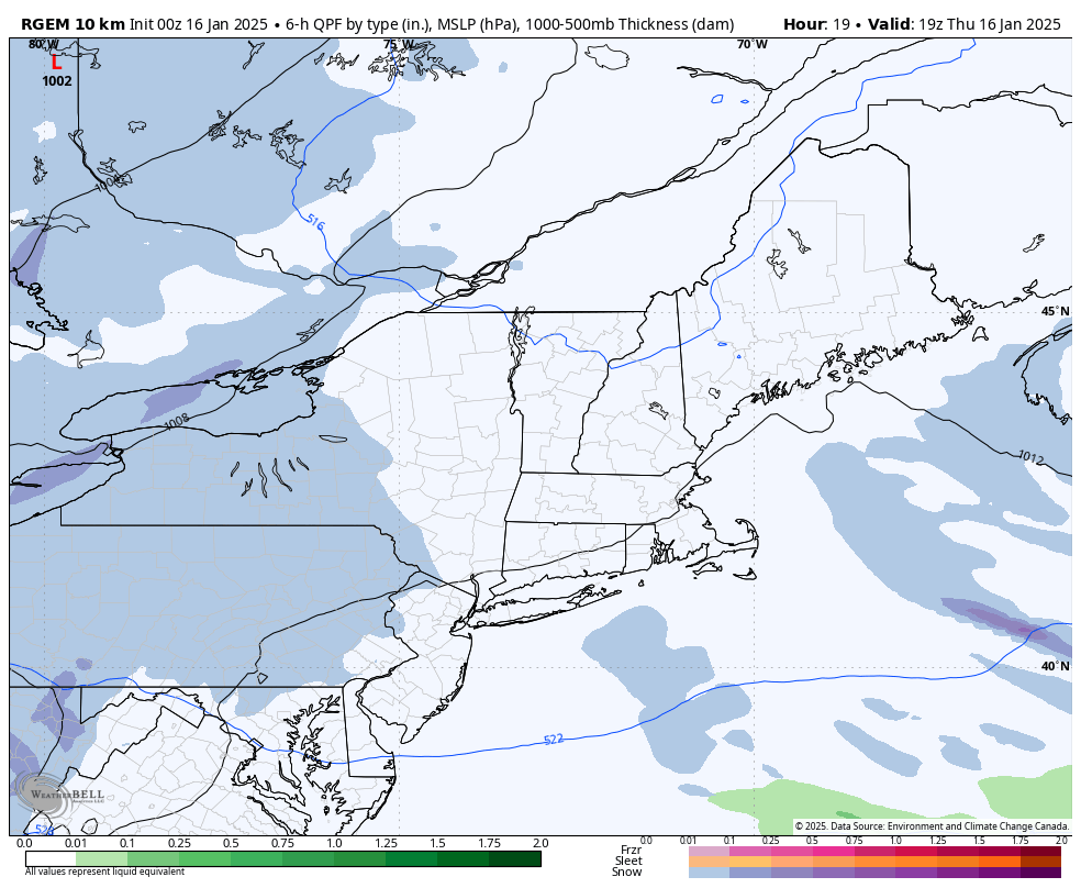
Blizzard of 93 replied to Voyager's topic in Upstate New York/Pennsylvania
0z RGEM is on board for around 1 inch of snow in Harrisburg tomorrow.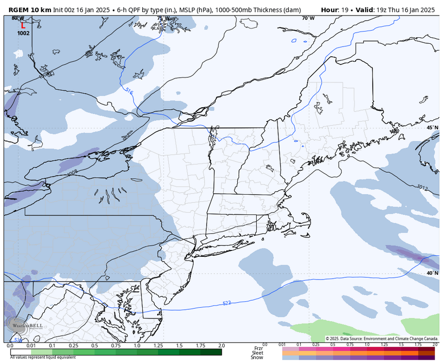
-
Central PA Winter 2024/2025
Blizzard of 93 replied to Voyager's topic in Upstate New York/Pennsylvania
Thanks for that post earlier on this. As you said, MDT is only around 3 inches of snow below normal to date. Lots of time to cash in. -
Central PA Winter 2024/2025
Blizzard of 93 replied to Voyager's topic in Upstate New York/Pennsylvania
This pattern has a lot of potential. Many scenarios are in play for potential events over the next 2 weeks. Plenty of cold in the pattern…it’s just a matter of timing up the precip. -
Central PA Winter 2024/2025
Blizzard of 93 replied to Voyager's topic in Upstate New York/Pennsylvania
And prime climo for big events for our region is mid January through at least President’s Day in February.