Blizzard of 93
-
Posts
13,045 -
Joined
-
Last visited
Content Type
Profiles
Blogs
Forums
American Weather
Media Demo
Store
Gallery
Everything posted by Blizzard of 93
-
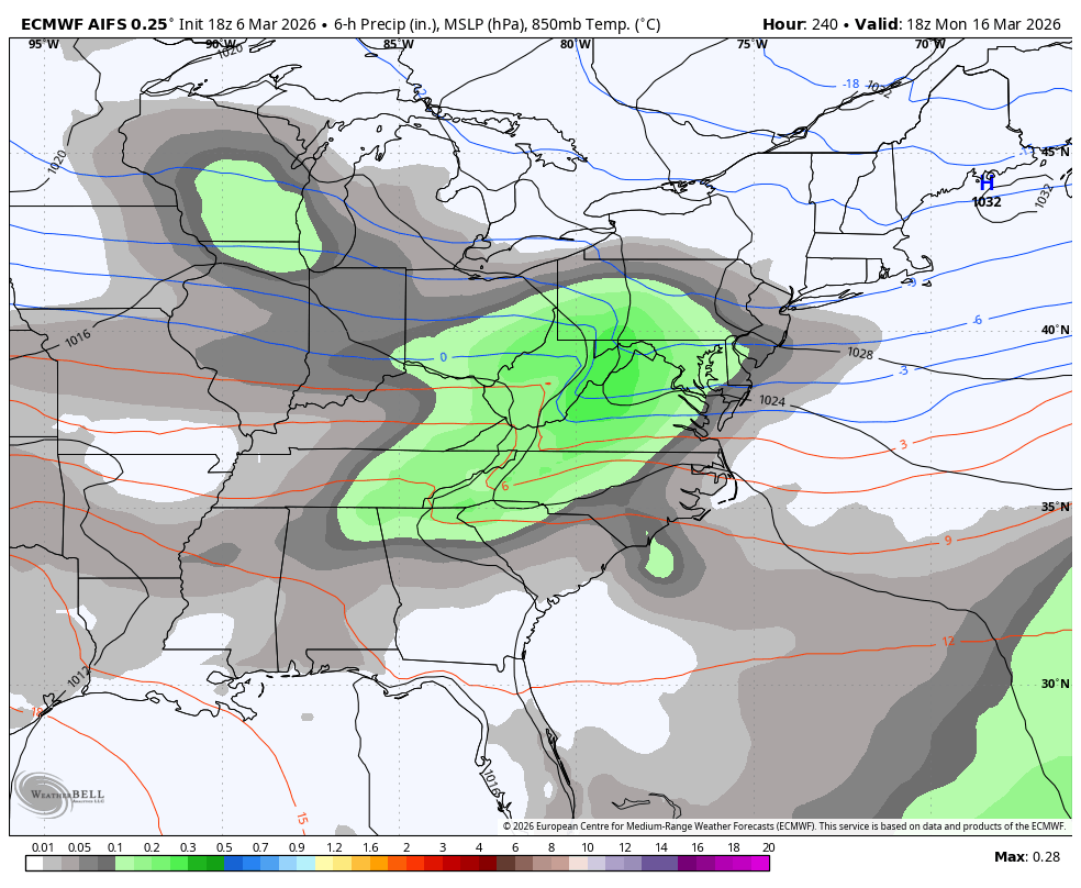
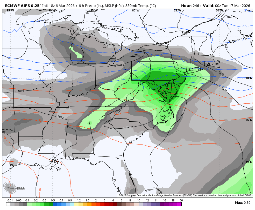
18z Euro AI delivers the Happy hour goods just in time for St. Patty’s Day!


-
Central PA Spring 2026 Discussion/Obs Thread
Blizzard of 93 replied to Voyager's topic in Upstate New York/Pennsylvania
I’m looking forward to our 3 or 4 day warm up while actively tracking snow chances around St.Patty’s Day! I am hunting that 6.2 of snow to get MDT to climo seasonal average! -
Central PA Spring 2026 Discussion/Obs Thread
Blizzard of 93 replied to Voyager's topic in Upstate New York/Pennsylvania
Lol, the 0z Euro supports the folklore! Hopefully this upcoming window can produce at least one more trackable snow chance. I want 6.2 more inches of snow at MDT this season in order get the seasonal total to the 30 inch climo average. The 0z Euro would deliver it. Give me this to verify & then I would be good with moving on to Spring. -
Central PA Spring 2026 Discussion/Obs Thread
Blizzard of 93 replied to Voyager's topic in Upstate New York/Pennsylvania
Here is our next window of Winter opportunity after the muted warmup. -
Central PA Spring 2026 Discussion/Obs Thread
Blizzard of 93 replied to Voyager's topic in Upstate New York/Pennsylvania
Thunderstorms in Winter mean snow within 10 days according to the old time folklore! -
Central PA Spring 2026 Discussion/Obs Thread
Blizzard of 93 replied to Voyager's topic in Upstate New York/Pennsylvania
More on the Winter comeback potential from @bncho in the Mid Atlantic thread… Euro AI has back to back hits. -
Central PA Spring 2026 Discussion/Obs Thread
Blizzard of 93 replied to Voyager's topic in Upstate New York/Pennsylvania
It’s a shame that the energy with this current system didn’t bundle into one main system yesterday or early today while we had the cold air mass in place. -
Central PA Spring 2026 Discussion/Obs Thread
Blizzard of 93 replied to Voyager's topic in Upstate New York/Pennsylvania
It is remarkable seeing how historically dry it was this Winter. We are probably lucky that MDT has about 24 inches of snow for the season given how little precip that there actually was to work with this Met Winter season. -
Central PA Spring 2026 Discussion/Obs Thread
Blizzard of 93 replied to Voyager's topic in Upstate New York/Pennsylvania
This literally made me lol, well done! -
Central PA Spring 2026 Discussion/Obs Thread
Blizzard of 93 replied to Voyager's topic in Upstate New York/Pennsylvania
0z Euro also looked to be loading up for another potential Winter comeback possibility at the end of the 15 day run. -
Central PA Spring 2026 Discussion/Obs Thread
Blizzard of 93 replied to Voyager's topic in Upstate New York/Pennsylvania
0z Euro showed the Winter comeback potential with a chance on the 16th this run. -
Central PA Spring 2026 Discussion/Obs Thread
Blizzard of 93 replied to Voyager's topic in Upstate New York/Pennsylvania
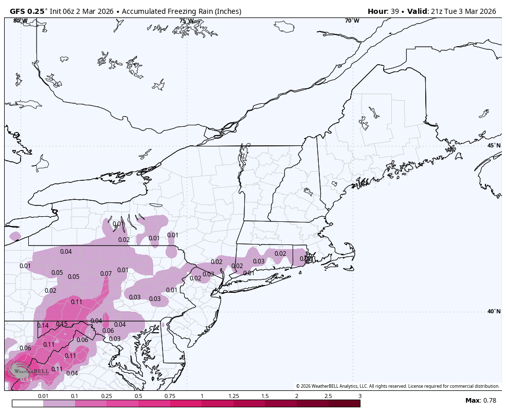
30 in Marysville with light freezing rain at 7 am. It looks like that there was some sleet earlier, but mostly freezing rain here. Car tops & non treated surfaces are encrusted. -
Central PA Spring 2026 Discussion/Obs Thread
Blizzard of 93 replied to Voyager's topic in Upstate New York/Pennsylvania
I’ve got lots more that I could post, but I think “most” posters should see my point. -
Central PA Spring 2026 Discussion/Obs Thread
Blizzard of 93 replied to Voyager's topic in Upstate New York/Pennsylvania
Snow chances tbd… but I think we will have our chances based on the pattern with the MJO moving towards phase 8 and the -WPO. -
Central PA Spring 2026 Discussion/Obs Thread
Blizzard of 93 replied to Voyager's topic in Upstate New York/Pennsylvania
Well, I was told earlier that there was no evidence that the pattern could turn colder… -
Central PA Spring 2026 Discussion/Obs Thread
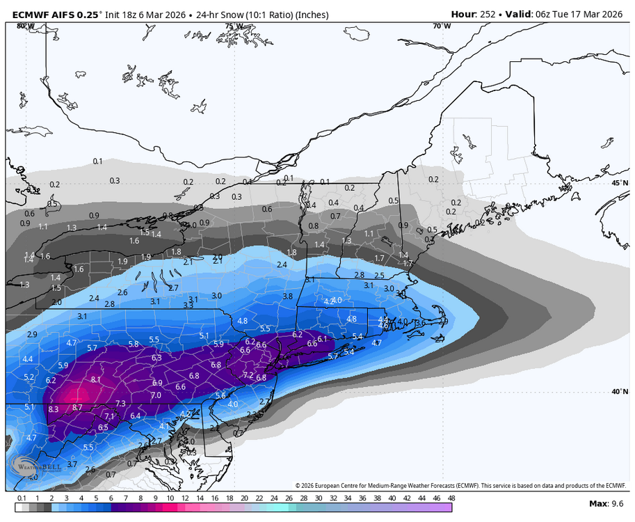
Blizzard of 93 replied to Voyager's topic in Upstate New York/Pennsylvania
How about more “evidence” on the highly regarded 18z AI EPS. Lots of cold green temps showing up nearby on St. Patty’s Day. -
Central PA Spring 2026 Discussion/Obs Thread
Blizzard of 93 replied to Voyager's topic in Upstate New York/Pennsylvania
More “evidence” on the 18z GEFS towards mid month. -
Central PA Spring 2026 Discussion/Obs Thread
Blizzard of 93 replied to Voyager's topic in Upstate New York/Pennsylvania
How about the “evidence” on the best ensemble in the world, the EPS from 12z today. By March 14, the colder pattern is emerging & remains in place at the end of the run on day 15. -
Central PA Spring 2026 Discussion/Obs Thread
Blizzard of 93 replied to Voyager's topic in Upstate New York/Pennsylvania
No final grade from me until April 10th, lol! -
Central PA Spring 2026 Discussion/Obs Thread
Blizzard of 93 replied to Voyager's topic in Upstate New York/Pennsylvania
Lol, lots of “evidence” will be posted later this evening showing why the cold & potential snow chances could be coming back by mid month. -
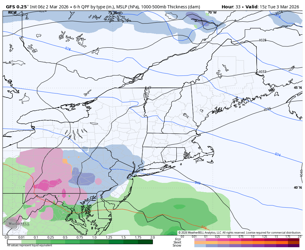
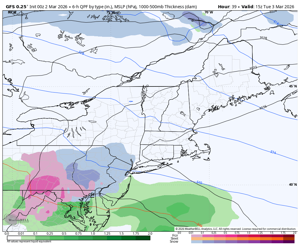
Central PA Winter 25/26 Discussion and Obs
Blizzard of 93 replied to MAG5035's topic in Upstate New York/Pennsylvania
Here’s the 6z GFS for overnight into Tuesday.
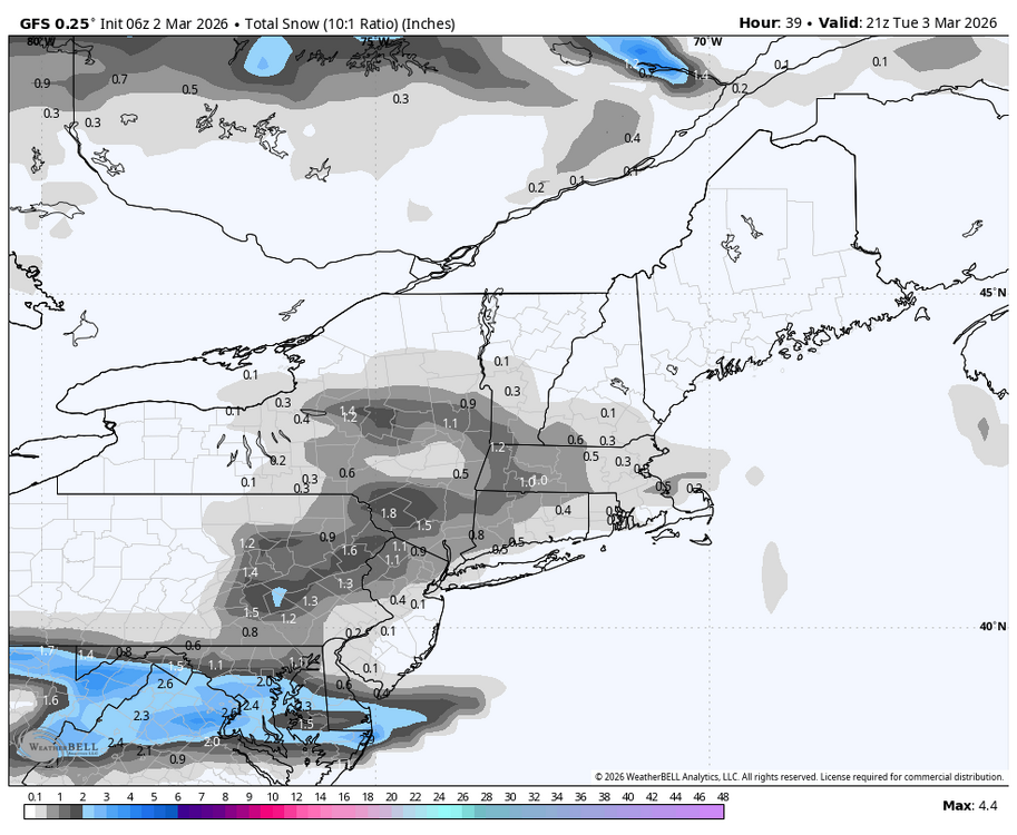

-
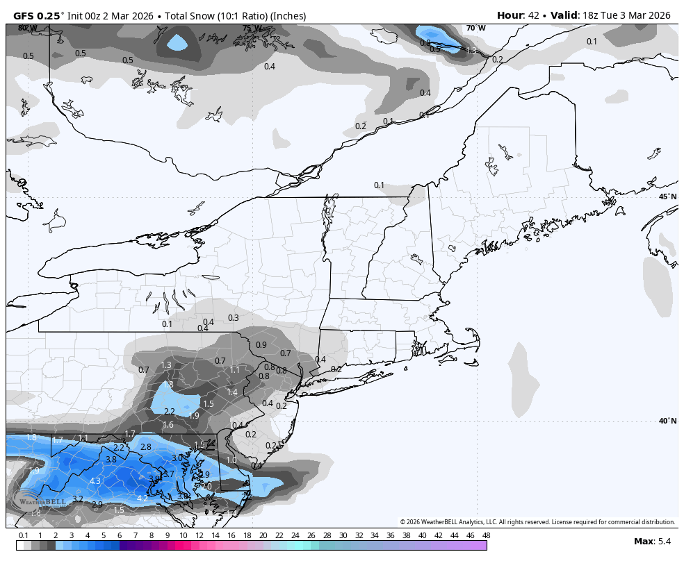
Central PA Spring 2026 Discussion/Obs Thread
Blizzard of 93 replied to Voyager's topic in Upstate New York/Pennsylvania
0z GFS is bringing a little more juice with wave 2, bringing it in earlier with a little more snow this run for the LSV .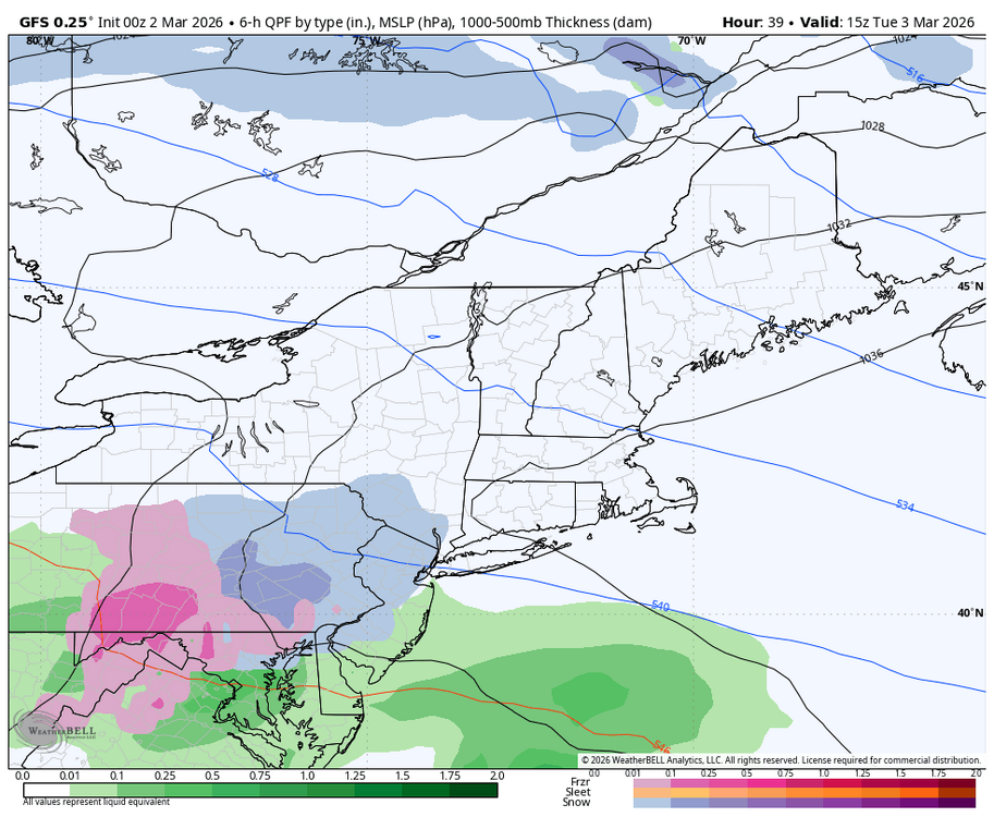

-
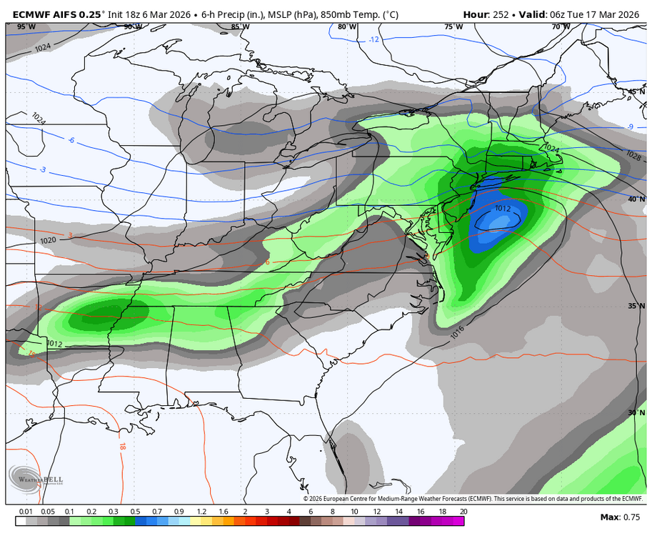
Central PA Spring 2026 Discussion/Obs Thread
Blizzard of 93 replied to Voyager's topic in Upstate New York/Pennsylvania
By next Friday, the cold returns. It is showing across all ensemble guidance that the trough is back in the east by mid month. We are far from done with Winter. -
Central PA Spring 2026 Discussion/Obs Thread
Blizzard of 93 replied to Voyager's topic in Upstate New York/Pennsylvania
I’ve seen final grades by posters scattered around the various regional threads. My point is that there is plenty of time for grading, when we are actually done. -
Central PA Spring 2026 Discussion/Obs Thread
Blizzard of 93 replied to Voyager's topic in Upstate New York/Pennsylvania
Well, like I said, lots of Winter to go…lol! People should wait until April 10th to give a final Winter grade in my opinion. I have enjoyed the couple of warm days that we’ve had in the last week or so & I’ll enjoy the warm up later this week, all while tracking the chance of every last flake until the true end of possibilities next month.