Blizzard of 93
-
Posts
13,009 -
Joined
-
Last visited
Content Type
Profiles
Blogs
Forums
American Weather
Media Demo
Store
Gallery
Everything posted by Blizzard of 93
-
Central PA Spring 2026 Discussion/Obs Thread
Blizzard of 93 replied to Voyager's topic in Upstate New York/Pennsylvania
Also, my annual general hibernation time on here is coming up when snow chances end. I won’t be involved in the drought talks… I might come on here to complain about high dew points… Maybe check in during thunderstorm chances… -
Central PA Spring 2026 Discussion/Obs Thread
Blizzard of 93 replied to Voyager's topic in Upstate New York/Pennsylvania
I just tire quickly of endless drought talk like the sky is falling or something. We will survive, promise… -
Central PA Spring 2026 Discussion/Obs Thread
Blizzard of 93 replied to Voyager's topic in Upstate New York/Pennsylvania
Nope, I am feeling it for a nice moderate hit chance for all us next week. The advertised pattern on the better models support it. -
E PA/NJ/DE Winter 2025-26 Obs/Discussion
Blizzard of 93 replied to LVblizzard's topic in Philadelphia Region


-
E PA/NJ/DE Winter 2025-26 Obs/Discussion
Blizzard of 93 replied to LVblizzard's topic in Philadelphia Region
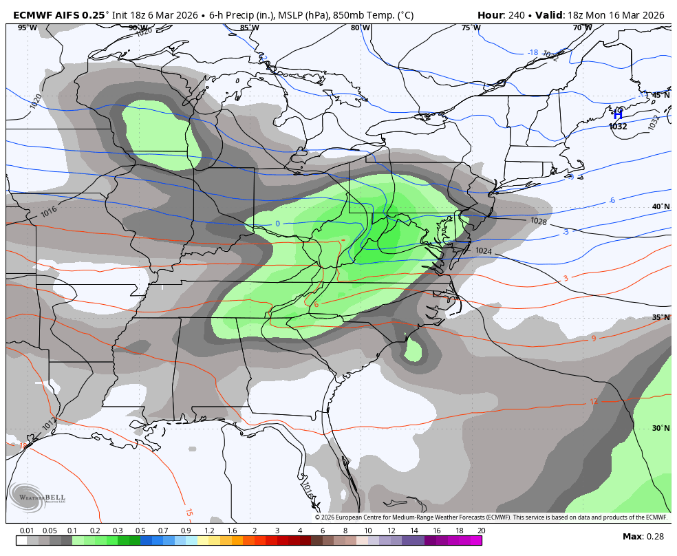
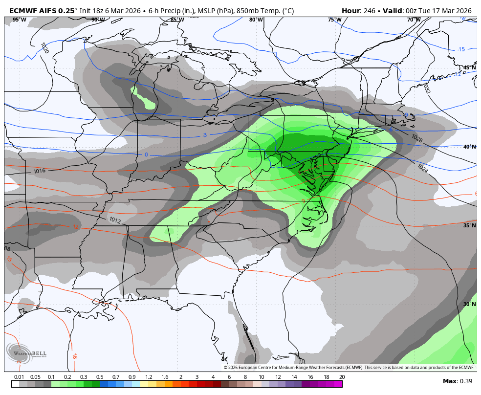
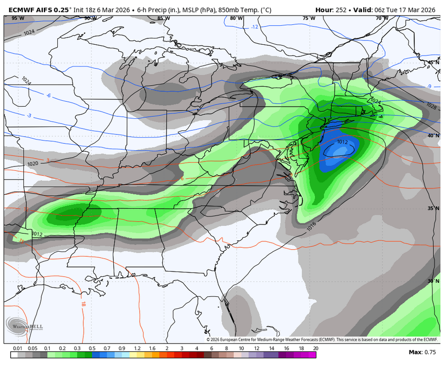
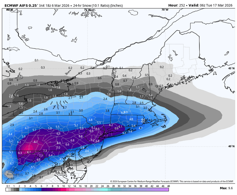
0z Euro has the St.Patty’s Day chance again.
-
Central PA Spring 2026 Discussion/Obs Thread
Blizzard of 93 replied to Voyager's topic in Upstate New York/Pennsylvania
-
0z Euro has the St.Patty’s Day chance again.
-
Central PA Spring 2026 Discussion/Obs Thread
Blizzard of 93 replied to Voyager's topic in Upstate New York/Pennsylvania
0z Euro has the St.Patty’s Day chance again.
-

-
0z Euro has the St.Patty’s Day chance again.
-
Central PA Spring 2026 Discussion/Obs Thread
Blizzard of 93 replied to Voyager's topic in Upstate New York/Pennsylvania
I can’t wait for more drought maps right after it rains… great times ahead. Just give me one more good snowstorm & then I will be ready for Spring. -
Central PA Spring 2026 Discussion/Obs Thread
Blizzard of 93 replied to Voyager's topic in Upstate New York/Pennsylvania
Winter is not over! No grades from me until April 10th when it becomes almost impossible to snow around here at that point. -
Central PA Spring 2026 Discussion/Obs Thread
Blizzard of 93 replied to Voyager's topic in Upstate New York/Pennsylvania
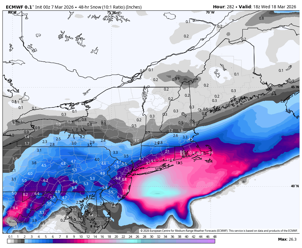
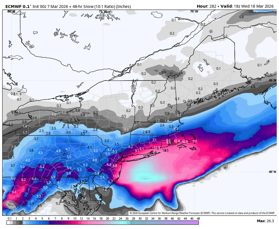
18z Euro AI delivers the Happy hour goods just in time for St. Patty’s Day!

-
18z Euro AI delivers the Happy hour goods just in time for St. Patty’s Day!
-
Central PA Spring 2026 Discussion/Obs Thread
Blizzard of 93 replied to Voyager's topic in Upstate New York/Pennsylvania
I’m looking forward to our 3 or 4 day warm up while actively tracking snow chances around St.Patty’s Day! I am hunting that 6.2 of snow to get MDT to climo seasonal average! -
Central PA Spring 2026 Discussion/Obs Thread
Blizzard of 93 replied to Voyager's topic in Upstate New York/Pennsylvania
Lol, the 0z Euro supports the folklore! Hopefully this upcoming window can produce at least one more trackable snow chance. I want 6.2 more inches of snow at MDT this season in order get the seasonal total to the 30 inch climo average. The 0z Euro would deliver it. Give me this to verify & then I would be good with moving on to Spring. -
Central PA Spring 2026 Discussion/Obs Thread
Blizzard of 93 replied to Voyager's topic in Upstate New York/Pennsylvania
Here is our next window of Winter opportunity after the muted warmup. -
Central PA Spring 2026 Discussion/Obs Thread
Blizzard of 93 replied to Voyager's topic in Upstate New York/Pennsylvania
Thunderstorms in Winter mean snow within 10 days according to the old time folklore! -
Central PA Spring 2026 Discussion/Obs Thread
Blizzard of 93 replied to Voyager's topic in Upstate New York/Pennsylvania
More on the Winter comeback potential from @bncho in the Mid Atlantic thread… Euro AI has back to back hits. -
Central PA Spring 2026 Discussion/Obs Thread
Blizzard of 93 replied to Voyager's topic in Upstate New York/Pennsylvania
It’s a shame that the energy with this current system didn’t bundle into one main system yesterday or early today while we had the cold air mass in place. -
Central PA Spring 2026 Discussion/Obs Thread
Blizzard of 93 replied to Voyager's topic in Upstate New York/Pennsylvania
It is remarkable seeing how historically dry it was this Winter. We are probably lucky that MDT has about 24 inches of snow for the season given how little precip that there actually was to work with this Met Winter season. -
Central PA Spring 2026 Discussion/Obs Thread
Blizzard of 93 replied to Voyager's topic in Upstate New York/Pennsylvania
This literally made me lol, well done! -
Central PA Spring 2026 Discussion/Obs Thread
Blizzard of 93 replied to Voyager's topic in Upstate New York/Pennsylvania
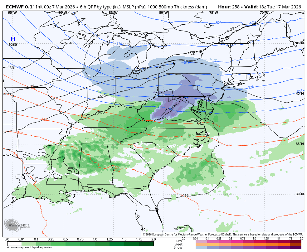
0z Euro also looked to be loading up for another potential Winter comeback possibility at the end of the 15 day run. -
Central PA Spring 2026 Discussion/Obs Thread
Blizzard of 93 replied to Voyager's topic in Upstate New York/Pennsylvania
0z Euro showed the Winter comeback potential with a chance on the 16th this run.