Blizzard of 93
-
Posts
13,037 -
Joined
-
Last visited
Content Type
Profiles
Blogs
Forums
American Weather
Media Demo
Store
Gallery
Everything posted by Blizzard of 93
-
Central PA - Jan 31 to Feb 2 Winter Storm
Blizzard of 93 replied to MAG5035's topic in Upstate New York/Pennsylvania
Steady light snow continues in Marysville. The wind is causing some minor drifting. I Love Winter! 11 inches for the event total as of 11 pm in Marysville. -
Central PA - Jan 31 to Feb 2 Winter Storm
Blizzard of 93 replied to MAG5035's topic in Upstate New York/Pennsylvania
It was good to have you back for this storm! -
Central PA - Jan 31 to Feb 2 Winter Storm
Blizzard of 93 replied to MAG5035's topic in Upstate New York/Pennsylvania
Good thing that dry slot that you were worried about yesterday filled in ....just kidding around! Lol... Congrats! I am happy you got crushed! -
Central PA - Jan 31 to Feb 2 Winter Storm
Blizzard of 93 replied to MAG5035's topic in Upstate New York/Pennsylvania
The latest HRRR has around 4 more inches of snow for the LSV by tomorrow morning. -
Central PA - Jan 31 to Feb 2 Winter Storm
Blizzard of 93 replied to MAG5035's topic in Upstate New York/Pennsylvania
Steady moderate snow continues in Marysville. 10 inches for the storm so far....hopefully a few more to go tonight and tomorrow. -
Central PA - Jan 31 to Feb 2 Winter Storm
Blizzard of 93 replied to MAG5035's topic in Upstate New York/Pennsylvania
Moderate snow continues. This is 1 inch per hour snow! I think we are in great shape...look at that radar with precip backing in from the ocean solidly still backing in towards Beford at this time! -
Central PA - Jan 31 to Feb 2 Winter Storm
Blizzard of 93 replied to MAG5035's topic in Upstate New York/Pennsylvania
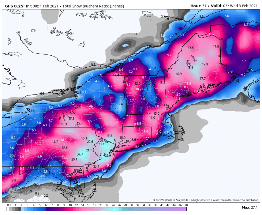
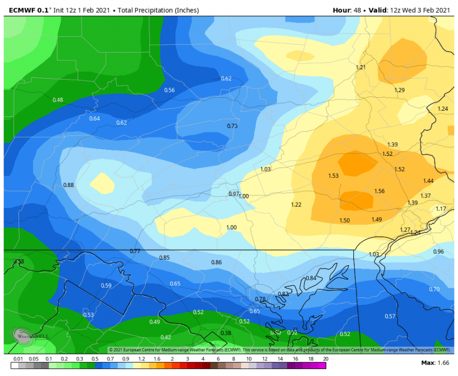
It’s a little late for globals, but the Euro has at least moderate snow over many of us until overnight tonight, then tapers to light snow/snow showers through tomorrow. We still have a long way to go! Here is the 12z Euro QPF & Kuchera snow.
-
Central PA - Jan 31 to Feb 2 Winter Storm
Blizzard of 93 replied to MAG5035's topic in Upstate New York/Pennsylvania
Heavy snow here again now! I got in that heavy band that @sauss06 was in this morning between 9 and 10 that put down a quick inch earlier. This snow will add up quickly! -
Central PA - Jan 31 to Feb 2 Winter Storm
Blizzard of 93 replied to MAG5035's topic in Upstate New York/Pennsylvania
The snow should last until late evening at least & then taper to light snow/snow showers by tomorrow. This low is going to take its sweet time moving out! -
Central PA - Jan 31 to Feb 2 Winter Storm
Blizzard of 93 replied to MAG5035's topic in Upstate New York/Pennsylvania
Thanks! Exactly! The radar looks fantastic! I just took a look at my lunch break and could not believe all of the doom & gloom posts. The back edge of the wrap around is still back building in western PA. There is a heavy band that has been backing in the western LSV all morning. The heavy fire hose band in eastern PA is moving due west towards south central PA. Everything is filling in and it soon should be game on! Mr. Horst should be right, as usual! -
Central PA - Jan 31 to Feb 2 Winter Storm
Blizzard of 93 replied to MAG5035's topic in Upstate New York/Pennsylvania
Yes, for the 6z runs, the amounts start at 6z (1am) and then go through the end of the event. -
Central PA - Jan 31 to Feb 2 Winter Storm
Blizzard of 93 replied to MAG5035's topic in Upstate New York/Pennsylvania
Harrisburg (MDT) reported 4.6 inches of snow as of Midnight. If they get the 7 inches of snow from the “Expected Snow” map, then that would put the event total at 11.6, which would be a close match to our December snowstorm total. -
Central PA - Jan 31 to Feb 2 Winter Storm
Blizzard of 93 replied to MAG5035's topic in Upstate New York/Pennsylvania
Here are the additional snow Expected & High End chance snow maps from CTP from this morning to the end of the event. -
Central PA - Jan 31 to Feb 2 Winter Storm
Blizzard of 93 replied to MAG5035's topic in Upstate New York/Pennsylvania
Here is the latest Warning from CTP for the LSV. Winter Storm Warning URGENT - WINTER WEATHER MESSAGE National Weather Service State College PA 448 AM EST Mon Feb 1 2021 PAZ035-036-057-059-063>066-012200- /O.CON.KCTP.WS.W.0003.000000T0000Z-210202T1000Z/ Fulton-Franklin-Dauphin-Lebanon-Cumberland-Adams-York-Lancaster- Including the cities of McConnellsburg, Chambersburg, Harrisburg, Hershey, Lebanon, Carlisle, Gettysburg, York, and Lancaster 448 AM EST Mon Feb 1 2021 ...WINTER STORM WARNING REMAINS IN EFFECT UNTIL 5 AM EST TUESDAY... * WHAT...Heavy snow. Additional snow accumulations of 4 to 8 inches and ice accumulations of a light glaze. * WHERE...Portions of central Pennsylvania. * WHEN...Until 5 AM EST Tuesday. * IMPACTS...Travel could be very difficult. -
Central PA - Jan 31 to Feb 2 Winter Storm
Blizzard of 93 replied to MAG5035's topic in Upstate New York/Pennsylvania
The 6z Euro doesn’t have nearly as much QPF or snow as the 6z GFS & NAMs for the LSV. Which model will win? It’s time to watch the low track & radar and see how it unfolds today. -
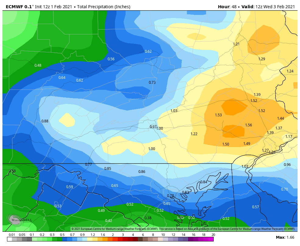
Central PA - Jan 31 to Feb 2 Winter Storm
Blizzard of 93 replied to MAG5035's topic in Upstate New York/Pennsylvania
This is just QPF from 1 am (6z) through the end of the event tomorrow night. -
Central PA - Jan 31 to Feb 2 Winter Storm
Blizzard of 93 replied to MAG5035's topic in Upstate New York/Pennsylvania
Look at the GFS & NAMs that I just posted....we don’t live in MD! -
Central PA - Jan 31 to Feb 2 Winter Storm
Blizzard of 93 replied to MAG5035's topic in Upstate New York/Pennsylvania
Both of 6z NAMs agree with the GFS. Much more on the way today! -
Central PA - Jan 31 to Feb 2 Winter Storm
Blizzard of 93 replied to MAG5035's topic in Upstate New York/Pennsylvania
On the 6z GFS, the CCB is well underway and really hitting hard at 4pm today and we are still getting impacted by the coastal at 4pm on Tuesday!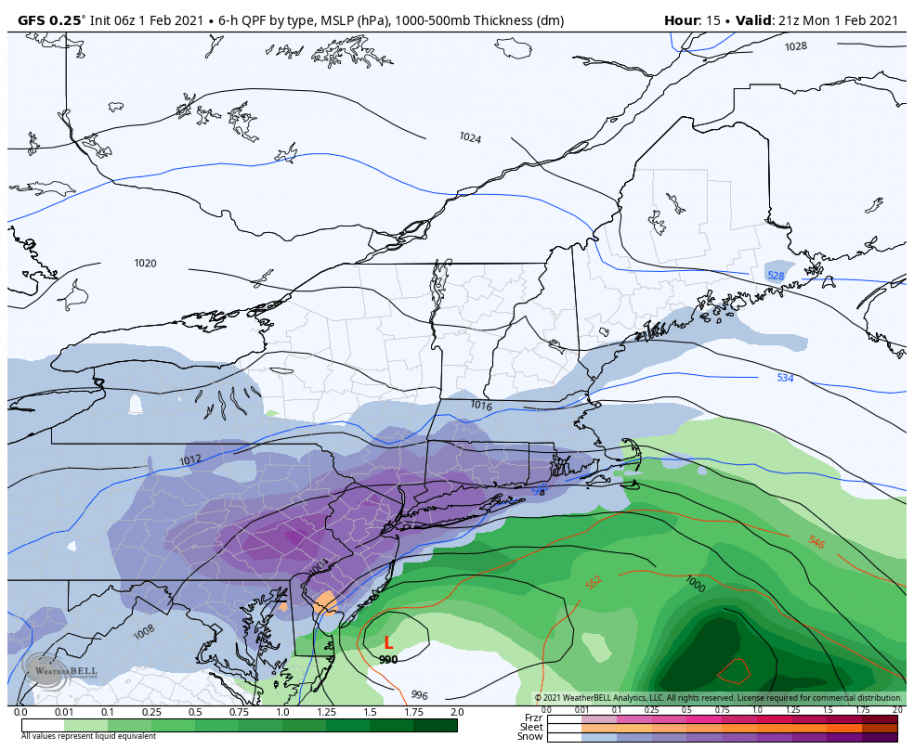
-
Central PA - Jan 31 to Feb 2 Winter Storm
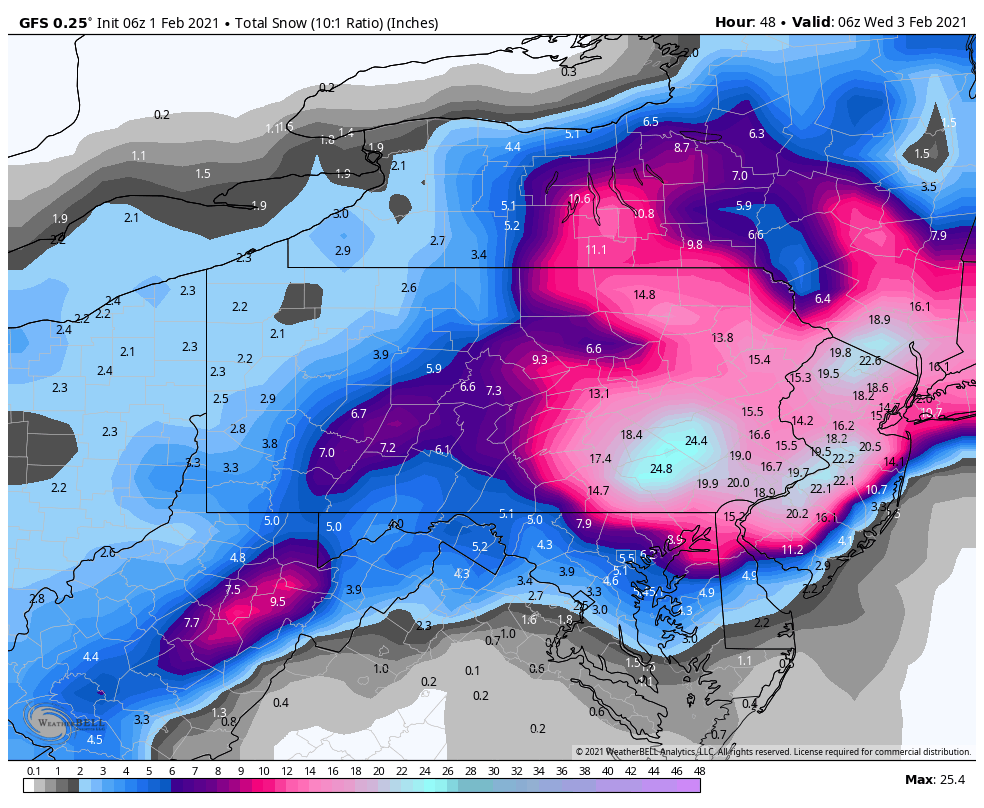
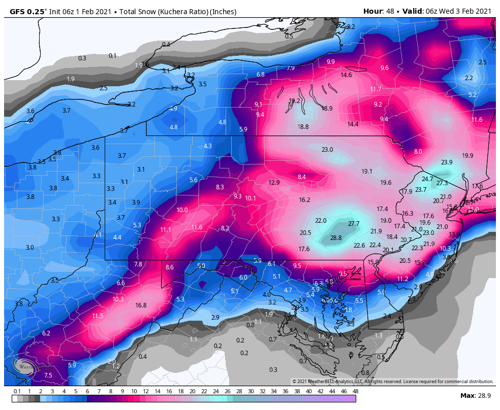
Blizzard of 93 replied to MAG5035's topic in Upstate New York/Pennsylvania
The 6z GFS brought the bullseye back to the Harrisburg, York, Lebanon & Lancaster! If this run is right, we snow until sometime on Tuesday! Here is the 6z GFS QPF, and 10-1 & Kuchera ratio snow. If this even comes close to verifying...just wow!

-
Central PA - Jan 31 to Feb 2 Winter Storm
Blizzard of 93 replied to MAG5035's topic in Upstate New York/Pennsylvania
Yes, it is starting to fill in & pivot even down into northern Virginia. -
Central PA - Jan 31 to Feb 2 Winter Storm
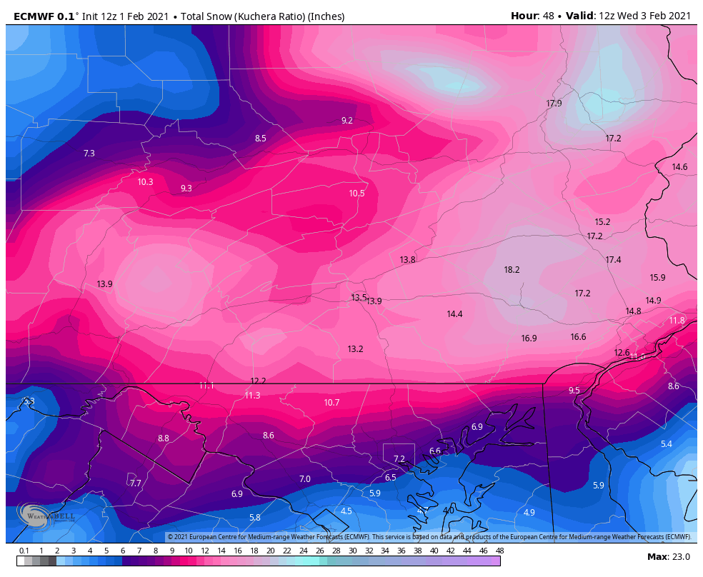
Blizzard of 93 replied to MAG5035's topic in Upstate New York/Pennsylvania
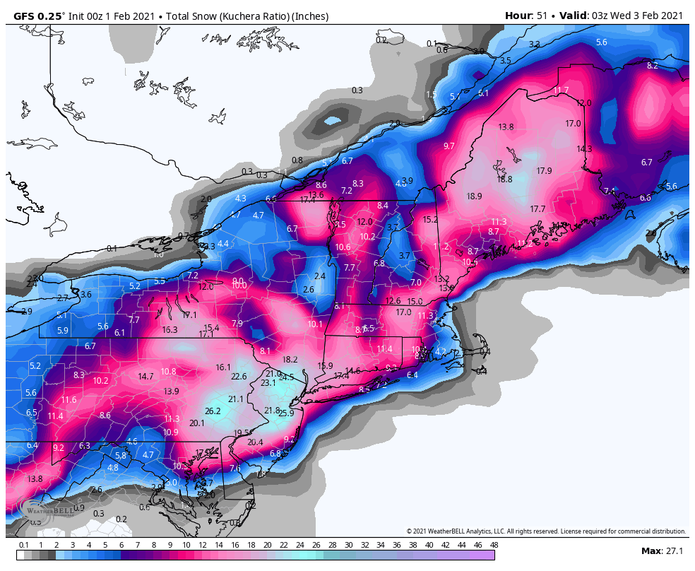
Here is the 0z Euro QPF & Kuchera map. We still have a long way to go. -
Central PA - Jan 31 to Feb 2 Winter Storm
Blizzard of 93 replied to MAG5035's topic in Upstate New York/Pennsylvania
Steady light to moderate snow in Marysville with 4 inches on the ground as of 11:50 pm. -
Central PA - Jan 31 to Feb 2 Winter Storm
Blizzard of 93 replied to MAG5035's topic in Upstate New York/Pennsylvania
No, the 18z Euro delivered a great amount of precip & snow for the coastal tomorrow into Tuesday am for most of us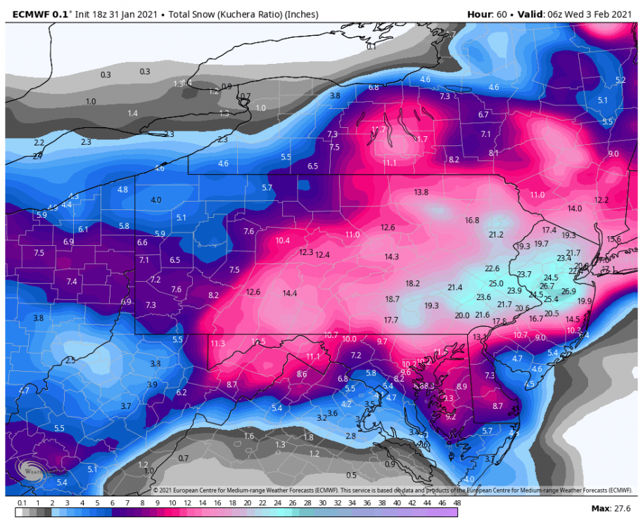
-
Central PA - Jan 31 to Feb 2 Winter Storm
Blizzard of 93 replied to MAG5035's topic in Upstate New York/Pennsylvania
It will depend on where the CCB sets up tomorrow. The best bands could end up further east or west. If the GFS verified verbatim, I could live with 11 more inches in the Harrisburg area.