Blizzard of 93
-
Posts
13,024 -
Joined
-
Last visited
Content Type
Profiles
Blogs
Forums
American Weather
Media Demo
Store
Gallery
Everything posted by Blizzard of 93
-
Central PA Winter 25/26 Discussion and Obs
Blizzard of 93 replied to MAG5035's topic in Upstate New York/Pennsylvania
I like this post from @mitchnick in his home away from home thread…. “It shows up on the snow depth map. Our snow depth (including sleet of course), is greater than some all snow locations thanks to the density of the sleet.” -
Central PA Winter 25/26 Discussion and Obs
Blizzard of 93 replied to MAG5035's topic in Upstate New York/Pennsylvania
MDT reported light snow the last couple of hours, so maybe we tack on a few tenths today to the monthly tally ? -
Central PA Winter 25/26 Discussion and Obs
Blizzard of 93 replied to MAG5035's topic in Upstate New York/Pennsylvania
For Friday, the Latest GFS & Euro both have a little snow for the Susquehanna Valley changing to an icy mix potential. The GFS brings more sleet & the Euro brings more freezing rain at this time. Still time, but for more snow instead of mix, we need that -NAO to flex a bit more to lock in that High in Quebec. -
Central PA Winter 25/26 Discussion and Obs
Blizzard of 93 replied to MAG5035's topic in Upstate New York/Pennsylvania
Bare ground in Marysville. If there were any flakes, I missed them. -
Central PA Winter 25/26 Discussion and Obs
Blizzard of 93 replied to MAG5035's topic in Upstate New York/Pennsylvania
0z GFS & 0z Canadian both show a sleet fest for many of us on Friday. -
Central PA Winter 25/26 Discussion and Obs
Blizzard of 93 replied to MAG5035's topic in Upstate New York/Pennsylvania
With that dew point you should drop to near 30 when precipitation arrives. Tonight is a light event, but it doesn’t take much frozen to cause road issues. -
Central PA Winter 25/26 Discussion and Obs
Blizzard of 93 replied to MAG5035's topic in Upstate New York/Pennsylvania
How did the 18z Euro AI & GFS AI trend for us for Friday? -
Central PA Winter 25/26 Discussion and Obs
Blizzard of 93 replied to MAG5035's topic in Upstate New York/Pennsylvania
Thankfully Mt. Holly has a very good discussion for the Friday potential… LONG TERM /FRIDAY THROUGH MONDAY/... Beyond Christmas Day, forecast uncertainty becomes very high. Guidance indicates there will be a high over eastern or southeastern Canada with low pressure moving eastward across the Great Lakes and toward the Northeast or Mid Atlantic. This setup will likely bring widespread precipitation to our area. The more recent trends over the last few runs from guidance has resulted in significant changes to the forecast. The main reason is a much stronger high that suppresses a weaker low. This trend keeps much of our area in a setup for colder air to remain in place thanks to the stronger high to the north. A more suppressed and southern track of this low keeps widespread precipitation for the area but also prevents a lot of the warm air advection from getting into the region. The updated forecast now has highs on Friday in the mid to upper 30s for the I- 95 corridor and west with mid to upper 20s in the Poconos. Areas south and east of the I-95 corridor have highs in the low to mid 40s. Wintry precipitation is now the result for much of the area for at least part of the timeframe from daybreak Friday into Saturday. Mixed precipitation may make it as far south as parts of Delmarva. -
Central PA Winter 25/26 Discussion and Obs
Blizzard of 93 replied to MAG5035's topic in Upstate New York/Pennsylvania
I’m not sure what CTP is thinking for Friday, but they have not updated their forecast discussion at all in the long range portion. They updated their point & click grids this afternoon as a few folks mentioned, but they still aren’t addressing the growing concern for Wintry weather on Friday, which again will be a major travel day for many. -
Central PA Winter 25/26 Discussion and Obs
Blizzard of 93 replied to MAG5035's topic in Upstate New York/Pennsylvania
MDT & Lancaster airport are both down to 31 degrees this hour with dew points in the low 20s at MDT & high teens in Lanco. Precip at least aloft has broken out in western PA. -
Central PA Winter 25/26 Discussion and Obs
Blizzard of 93 replied to MAG5035's topic in Upstate New York/Pennsylvania
For Friday, the 18z GFS still has snow to a nasty wintry mix potential. It will all depend on the strength & position of that High sitting over Quebec. Lots of time, but good to see the trend from last night hold for today’s runs so far. -
Central PA Winter 25/26 Discussion and Obs
Blizzard of 93 replied to MAG5035's topic in Upstate New York/Pennsylvania
If the trends from 0z & 6z on the Euro & GFS continue today, the forecasts for Friday will be changing rapidly. The 6z GFS has a snowstorm for southern PA & the 6z Euro shows an ice storm chance. The High is in a great spot, so let’s see how the trends go today. -
Central PA Winter 25/26 Discussion and Obs
Blizzard of 93 replied to MAG5035's topic in Upstate New York/Pennsylvania
No disappointment here, just a super busy time of year with the holidays! -
Central PA Winter 25/26 Discussion and Obs
Blizzard of 93 replied to MAG5035's topic in Upstate New York/Pennsylvania
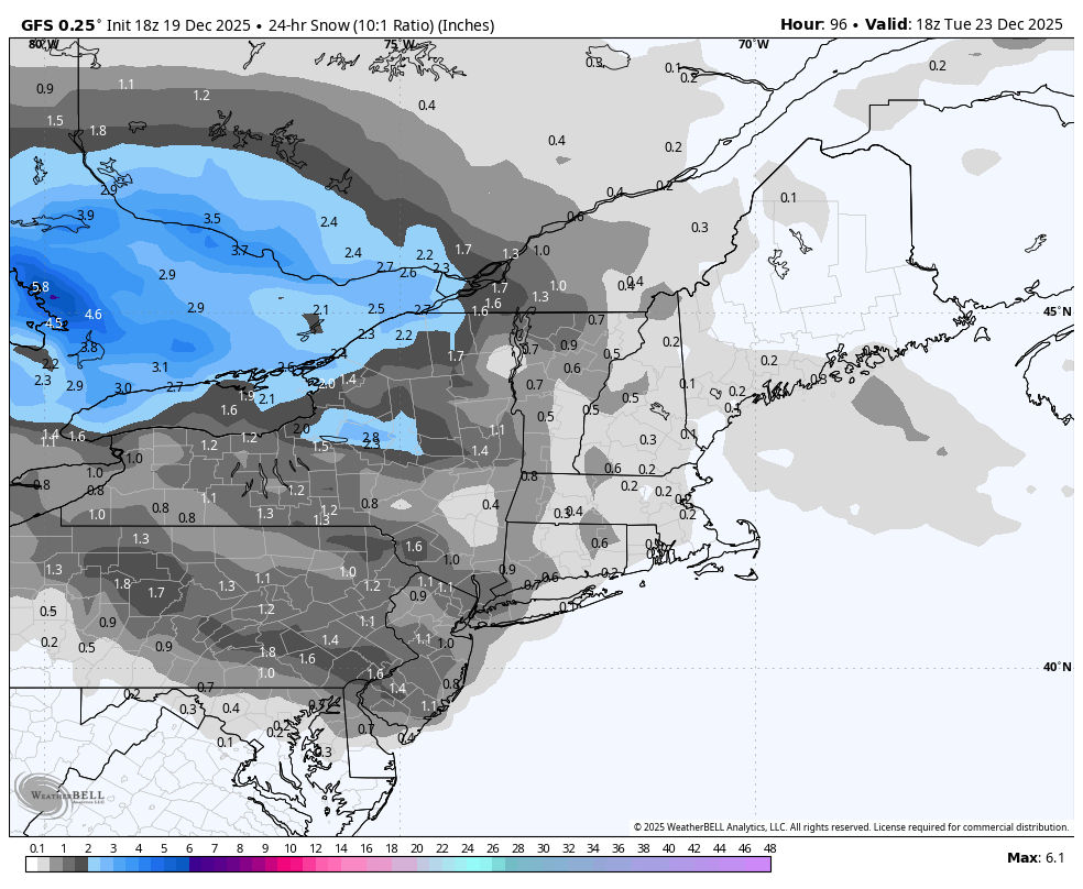
18z GFS is bringing 1 inch of snow to Harrisburg & Lancaster on Tuesday am, with closer to 3 inches for the Williamsport area.
-
Central PA Winter 25/26 Discussion and Obs
Blizzard of 93 replied to MAG5035's topic in Upstate New York/Pennsylvania
Certainly a few things to resolve out towards NY Eve… The 0z Euro says congrats Atlanta, while the 0z GFS says congrats PA. The extent & impact of the blocking will continue to throw models fits for the at least a few more days. -
Certainly a few things to resolve out towards NY Eve… The 0z Euro says congrats Atlanta, while the 0z GFS says congrats PA. The extent & impact of the blocking will continue to throw models fits for the at least a few more days.
-
Central PA Winter 25/26 Discussion and Obs
Blizzard of 93 replied to MAG5035's topic in Upstate New York/Pennsylvania
LONG TERM /MONDAY NIGHT THROUGH SATURDAY/... Overrunning precip on Monday night and Tuesday will be mainly snow overnight, but could turn to rain in the Laurels and central mtns before morning. As that change would occur, there is a strong possibility that some ZR will occur. We will continue to mention ZR in the wx grids and show a small patch of ice accum in the central mtns late Mon night and early Tues AM. We have 3 more periods to become more confident in the forecast, but may eventually need a wint wx advy for that time frame. Since there is expected to be SN at first and temps hovering in the 30-32F range for much of the CWA late Mon night and early Tues, the changeover to RA could occur without creating dangerous ZR. The highest threat of ice accumulations appears to be around AOO and UNV before sunrise. QPF will be almost nothing on the MD border, but a widespread 0.20" in the nrn half of the CWA. Most of that would be falling when it would be SN. SLRs are very low (<10:1), and accums will be a max of 1-2" with the highest accums in Tioga & Sullivan Cos. A coating (<1") is expected for much of the area before the SN turns to RA. The precip should lift off to the NE and be over around noon Tues. Temps max out in the upper 30s NE and near 50F between AOO and HGR. Gusts will increase Tuesday evening to the teens and 20s, but drop off through the day on Wed as high pressure moves in. -
Central PA Winter 25/26 Discussion and Obs
Blizzard of 93 replied to MAG5035's topic in Upstate New York/Pennsylvania
Here is CTP for Monday night/early Tuesday for the Harrisburg area. Monday Night Snow likely before 4am, then rain and snow likely. Cloudy, with a low around 30. Calm wind becoming southeast around 6 mph after midnight. Chance of precipitation is 60%. New snow accumulation of less than a half inch possible. -
Central PA Winter 25/26 Discussion and Obs
Blizzard of 93 replied to MAG5035's topic in Upstate New York/Pennsylvania
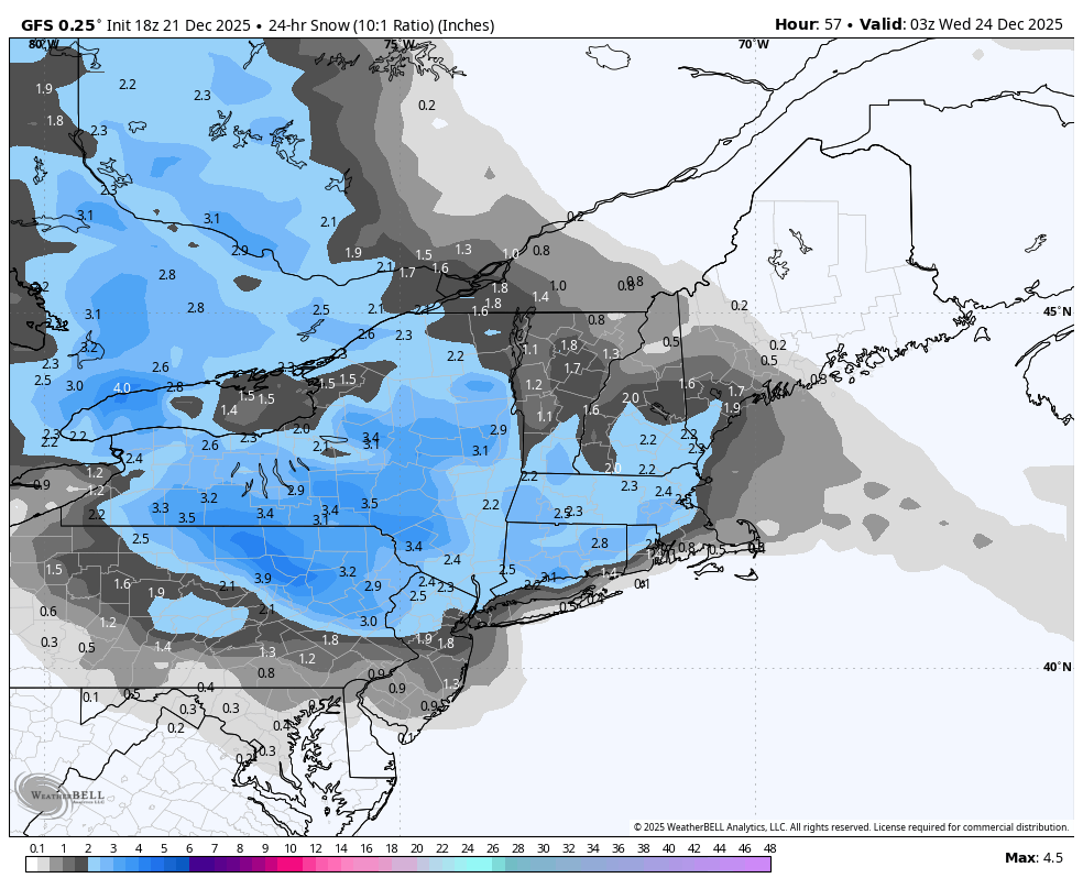
6z GFS still supports the idea of a little Tuesday am Christmas Eve Eve snow with showing around 1 inch in the LSV & near 3 near Williamsport. -
Central PA Winter 25/26 Discussion and Obs
Blizzard of 93 replied to MAG5035's topic in Upstate New York/Pennsylvania
0z GFS keeps even the LSV in the game for the chance of a little snow on Tuesday. -
JB says there is a 10 to 15 day lag after Europe gets cold until it gets cold in the east. He believes the trough will back in from the North Atlantic into the east.
-
Central PA Winter 25/26 Discussion and Obs
Blizzard of 93 replied to MAG5035's topic in Upstate New York/Pennsylvania
0z GFS & 6z GFS are still showing interesting looks for potential Winter storm chances towards end of the month into the first few days of the New Year. The onset of Blocking really throws models fits until they can see the full impact of the -NAO. If it sets up just right, we could be tracking a meaningful potential storm. The 0z GFS showed this beauty of a chance at the end of its run. -
Central PA Winter 25/26 Discussion and Obs
Blizzard of 93 replied to MAG5035's topic in Upstate New York/Pennsylvania
The 18z GFS got more interesting for the Tuesday am weak wave chance. This run gets 1 to 2 inches of snow into the LSV.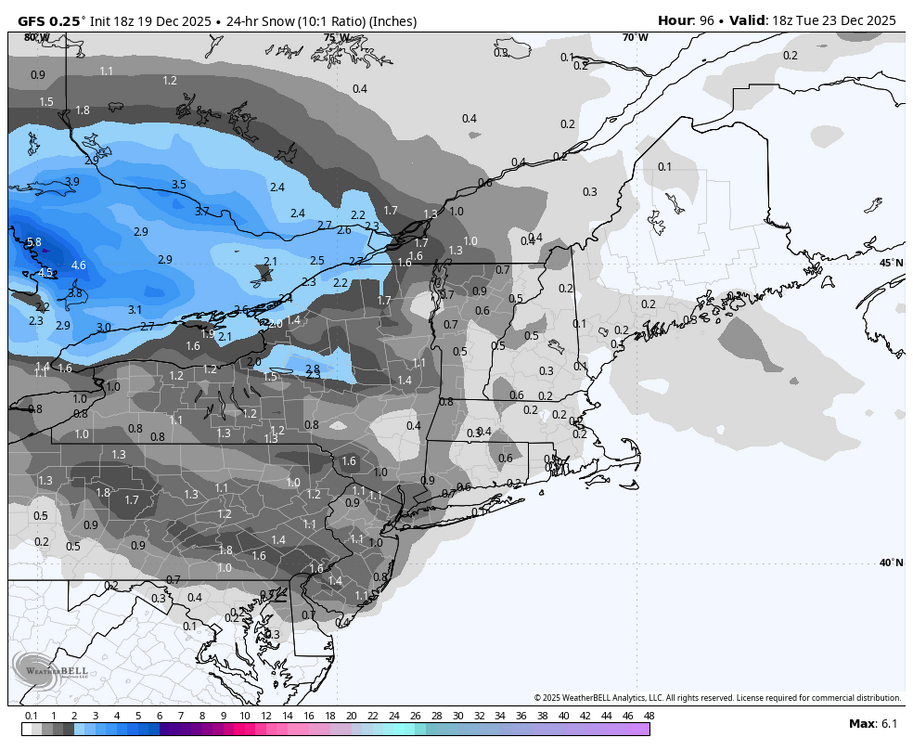
-
Central PA Winter 25/26 Discussion and Obs
Blizzard of 93 replied to MAG5035's topic in Upstate New York/Pennsylvania
Wild weather day! Heavy rain, followed by 2 hours of relatively warm sunshine, then more heavy rain & wind. Then, Snow showers when leaving my office in Harrisburg & snow showers in Marysville with a light dusting on car tops. -
Central PA Winter 25/26 Discussion and Obs
Blizzard of 93 replied to MAG5035's topic in Upstate New York/Pennsylvania
The 0z GFS brought back the potential chance for an end of the month coastal that is influenced by the -NAO.