Blizzard of 93
-
Posts
12,832 -
Joined
-
Last visited
Content Type
Profiles
Blogs
Forums
American Weather
Media Demo
Store
Gallery
Everything posted by Blizzard of 93
-
Central PA Fall Discussions and Obs
Blizzard of 93 replied to ChescoWx's topic in Upstate New York/Pennsylvania
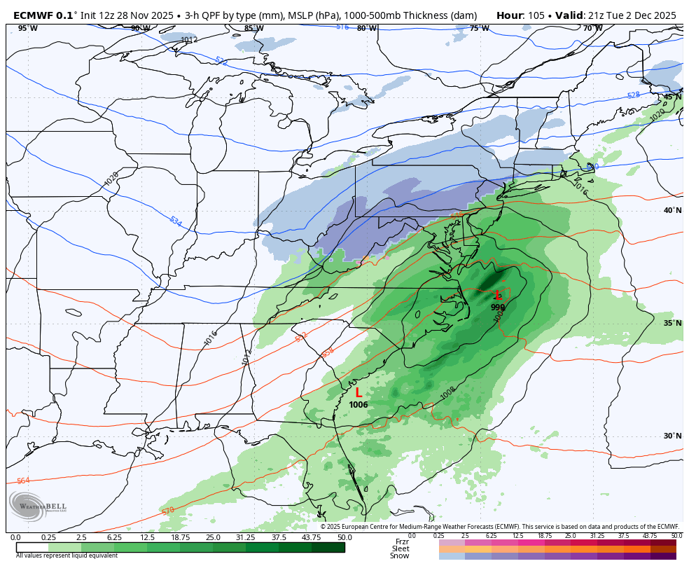
LONG TERM /MONDAY NIGHT THROUGH FRIDAY/... Unsettled weather will continue into the first week of December as cold air in the middle of the country sets up a strong baroclinic zone over the eastern US. High pressure in the Plains should keep cold air in place on the northern side of the precipitation shield from a wave of low pressure progged to move out of the Gulf. This system should move northeast around the base of the aforementioned high pressure system, bringing increasing moisture to the Mid-Atlantic Tuesday into Wednesday. The system at this time looks to be somewhat progressive with the lack of a strong area of high pressure to slow the advance of the system. Despite the expected fast forward movement, a deepening coastal low could still provide enough forcing juxtaposed with favorable upper jet dynamics to produce significant snowfall across the region. Snow looks to arrive later Monday night and lift across the region during the day on Monday. The eventual track and intensity of the low will have big implications on observed snowfall totals and the northward extent of any mix/rain scenarios. The latest WPC probabilities of 0.25" or greater liquid equivalent snow/sleet paint medium probabilities (40-70%) across most of the region, with slightly lower amounts expected in northwest PA. The latest Winter Storm Outlook highlights a 30-50% chance of Warning criteria snowfall (5"+) in northeast PA. GEFS and ECENS probabilities of 6"+ continue to outline probabilities <30% with a higher likelihood in northeast PA up through coastal New England. If confidence increases in higher amounts, Watches may be needed in the next 24-48 hours. At this time, though, a plowable snowfall seems like a reasonable bet for most of the region. Continue to monitor the forecast in the days ahead, especially if you have plans to travel. -
Central PA Fall Discussions and Obs
Blizzard of 93 replied to ChescoWx's topic in Upstate New York/Pennsylvania
CTP’s forecast discussion is very detailed this morning for the Tuesday potential. -
Central PA Fall Discussions and Obs
Blizzard of 93 replied to ChescoWx's topic in Upstate New York/Pennsylvania
He is typically forecasting for Lanco, which is very much on the fence for Tuesday. I think 90% of CTP is in good shape for our first measurable to plowable event of the season on Tuesday. -
Central PA Fall Discussions and Obs
Blizzard of 93 replied to ChescoWx's topic in Upstate New York/Pennsylvania
If I was in Lanco, I’d be concerned about Tuesday, but I think most of us are in good shape for at least our first measurable to maybe plowable event this season. -
Central PA Fall Discussions and Obs
Blizzard of 93 replied to ChescoWx's topic in Upstate New York/Pennsylvania
18z ICON for the win -
Central PA Fall Discussions and Obs
Blizzard of 93 replied to ChescoWx's topic in Upstate New York/Pennsylvania
12z Euro very similar to the Canadian. Im signing… again, lol!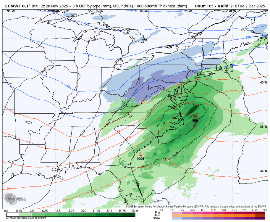
-
Central PA Fall Discussions and Obs
Blizzard of 93 replied to ChescoWx's topic in Upstate New York/Pennsylvania
The 12z Canadian is a solid middle ground, similar to recent Euro runs. I would sign for this on Tuesday.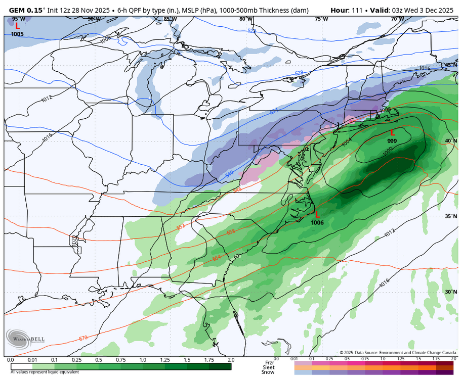
-
Central PA Fall Discussions and Obs
Blizzard of 93 replied to ChescoWx's topic in Upstate New York/Pennsylvania
We also need to look at the light chance early Sunday as well for minor potential of an appetizer. -
Central PA Fall Discussions and Obs
Blizzard of 93 replied to ChescoWx's topic in Upstate New York/Pennsylvania
0z Canadian looked decent as well for most of us. -
Central PA Fall Discussions and Obs
Blizzard of 93 replied to ChescoWx's topic in Upstate New York/Pennsylvania
6z Euro & 6z GFS are keeping CTP very much in the game. -
Central PA Fall Discussions and Obs
Blizzard of 93 replied to ChescoWx's topic in Upstate New York/Pennsylvania
Turkey hangovers for some of us … -
Central PA Fall Discussions and Obs
Blizzard of 93 replied to ChescoWx's topic in Upstate New York/Pennsylvania
18z GFS & 18z Euro say that most of CTP is still in the game for Tuesday. -
Central PA Fall Discussions and Obs
Blizzard of 93 replied to ChescoWx's topic in Upstate New York/Pennsylvania
12z GFS snow for just Tuesday. -
Central PA Fall Discussions and Obs
Blizzard of 93 replied to ChescoWx's topic in Upstate New York/Pennsylvania
-
Central PA Fall Discussions and Obs
Blizzard of 93 replied to ChescoWx's topic in Upstate New York/Pennsylvania
I’m thankful for the 12z GFS! -
Central PA Fall Discussions and Obs
Blizzard of 93 replied to ChescoWx's topic in Upstate New York/Pennsylvania
CTP is starting to mention the Tuesday chance. .SYNOPSIS... * Gusty west to northwest winds and much colder temperatures to end the week * Lake effect snow will result in significant Thanksgiving holiday travel disruptions across northwest Pennsylvania * Scattered snow showers and a few squalls will impact the weather across the Central Mtns, Laurel Highlands and possibly the Middle Susquehanna Valley Thanksgiving Day into Friday * A few periods of snow (Northern PA) and snow/or a wintry mix (Southern PA) late Saturday Night and Sunday * A more significant/widespread winter storm possible Tuesday and Tuesday night -
Central PA Fall Discussions and Obs
Blizzard of 93 replied to ChescoWx's topic in Upstate New York/Pennsylvania
The 6z Euro is looking good for Tuesday’s chance, especially back near I-81 to the west & north. -
Central PA Fall Discussions and Obs
Blizzard of 93 replied to ChescoWx's topic in Upstate New York/Pennsylvania
Happy Thanksgiving everyone! Hopefully this storm trends in the right direction today as we feast and then continues looking good as we enjoy the leftovers this weekend! -
Central PA Fall Discussions and Obs
Blizzard of 93 replied to ChescoWx's topic in Upstate New York/Pennsylvania
6z GFS snow map for just the Tuesday chance. -
Central PA Fall Discussions and Obs
Blizzard of 93 replied to ChescoWx's topic in Upstate New York/Pennsylvania
6z GFS delivered a good thump of snow, with most of us staying snow for a good portion of the potential Tuesday event below mixing to ice or rain. -
Central PA Fall Discussions and Obs
Blizzard of 93 replied to ChescoWx's topic in Upstate New York/Pennsylvania
0z GFS is amped & has a snow to mix to rain then back to a little snow at the end this run for southern PA. I-80 on north does well this run.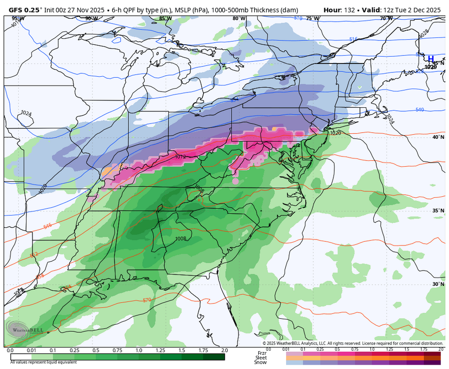
-
Central PA Fall Discussions and Obs
Blizzard of 93 replied to ChescoWx's topic in Upstate New York/Pennsylvania
18z Euro ends at 144 hours, but this run looks to be juicing up more in line with recent GFS runs. -
Central PA Fall Discussions and Obs
Blizzard of 93 replied to ChescoWx's topic in Upstate New York/Pennsylvania
Good to see the 12z GFS, Canadian & Euro each showing a winter storm chance for Tuesday at this point. Plenty of time to sort out the details, but it would be great to get on the board so early even if it ends up as a light event: It should be just the beginning of our chances in December. -
Central PA Fall Discussions and Obs
Blizzard of 93 replied to ChescoWx's topic in Upstate New York/Pennsylvania
This 6z GFS for mid next week is real nice. Let’s hope 12z continues in this direction. -
Central PA Fall Discussions and Obs
Blizzard of 93 replied to ChescoWx's topic in Upstate New York/Pennsylvania
0z GFS snow for the mid next week chance period this run. This is starting to get interesting…