Blizzard of 93
-
Posts
12,832 -
Joined
-
Last visited
Content Type
Profiles
Blogs
Forums
American Weather
Media Demo
Store
Gallery
Everything posted by Blizzard of 93
-
2 out of 3 ain’t bad… Also, @CAPE posted a good look on the GEFS a little earlier for around the 12th.
-
Central PA Winter 25/26 Discussion and Obs
Blizzard of 93 replied to MAG5035's topic in Upstate New York/Pennsylvania
12z EPS & 12z Canadian ensemble also are indicating that we should be back in the tracking business in the day 10 to 15 period. -
12z EPS & 12z Canadian ensemble also are indicating that we should be back in the tracking business in the day 10 to 15 period.
-
Central PA Winter 25/26 Discussion and Obs
Blizzard of 93 replied to MAG5035's topic in Upstate New York/Pennsylvania
Same plan here! Watching the parade & football later on. -
Central PA Winter 25/26 Discussion and Obs
Blizzard of 93 replied to MAG5035's topic in Upstate New York/Pennsylvania
Agreed, that’s what I’m going with as well. Unfortunately I slept through the squall, but it was great to wake up to this first day of the year! Happy New Year everyone! -
Central PA Winter 25/26 Discussion and Obs
Blizzard of 93 replied to MAG5035's topic in Upstate New York/Pennsylvania
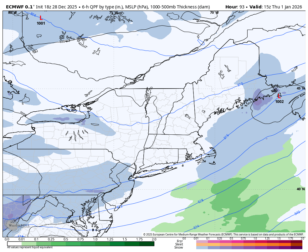
Here are CTP’s thoughts for tomorrow. By the mid to late afternoon (New Years Eve), a wave of low pressure will drift eastward across the Great Lakes, and drag an Arctic front south through the Commonwealth. Underneath a favorable left exit region of an upper jet, this front could produce a threat of snow squalls late Wednesday evening into the New Year. Current expectation is that the front and associated snow squall threat will move into northwest PA in the 6-8PM timeframe and then race southeast, crossing the I-99 corridor between 10PM and midnight and then getting into the Lower Susquehanna Valley between midnight and 2AM. Anyone planning to travel for the New Year should be prepared for the risk of snow squalls. If a Snow Squall Warning is issued, delay travel or exit the highway at the next opportunity. -
Central PA Winter 25/26 Discussion and Obs
Blizzard of 93 replied to MAG5035's topic in Upstate New York/Pennsylvania
It is relentless! -
Central PA Winter 25/26 Discussion and Obs
Blizzard of 93 replied to MAG5035's topic in Upstate New York/Pennsylvania
A few bouts of light snow showers on & off the last few hours between Harrisburg & Marysville. Oh, it’s also windy here. I’m not looking forward to finding my trash can tomorrow am, lol! -
Central PA Winter 25/26 Discussion and Obs
Blizzard of 93 replied to MAG5035's topic in Upstate New York/Pennsylvania
The January 8th/9th period is looking even more interesting. Great potential showing on the 12z Canadian & 18z GFS. -
Central PA Winter 25/26 Discussion and Obs
Blizzard of 93 replied to MAG5035's topic in Upstate New York/Pennsylvania
The 18z Euro still has the New Year’s Day clipper that gives many of us 1 to 2 inches of potential snow.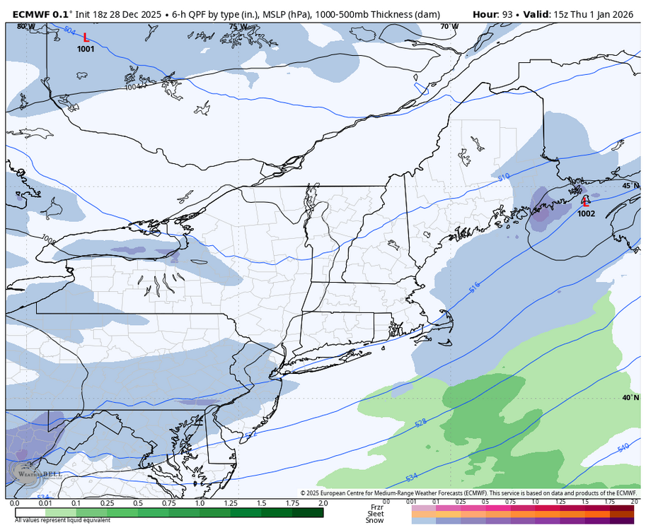
-
Central PA Winter 25/26 Discussion and Obs
Blizzard of 93 replied to MAG5035's topic in Upstate New York/Pennsylvania
I’m ready for something like this 12z Euro run for 1/9 to verify. -
It’s a good look & the key is that it is sustainable.
-
Central PA Winter 25/26 Discussion and Obs
Blizzard of 93 replied to MAG5035's topic in Upstate New York/Pennsylvania
6z GFS has this moisture laden storm on the 6th this run. The potential period is going to be interesting to track. -
Central PA Winter 25/26 Discussion and Obs
Blizzard of 93 replied to MAG5035's topic in Upstate New York/Pennsylvania
Here is the 0z EPS look for the day 10 to 15 period. -
Yes indeed, here is the 0z EPS look for the day 10 to 15 period.
-
Central PA Winter 25/26 Discussion and Obs
Blizzard of 93 replied to MAG5035's topic in Upstate New York/Pennsylvania
The first half of January looks to bring this potential… -
Central PA Winter 25/26 Discussion and Obs
Blizzard of 93 replied to MAG5035's topic in Upstate New York/Pennsylvania
Next up for a light snow chance is another Clipper potential around New Year’s Day. -
Central PA Winter 25/26 Discussion and Obs
Blizzard of 93 replied to MAG5035's topic in Upstate New York/Pennsylvania
The upcoming advertised pattern during the first half of January says “buckle up”! -
Central PA Winter 25/26 Discussion and Obs
Blizzard of 93 replied to MAG5035's topic in Upstate New York/Pennsylvania
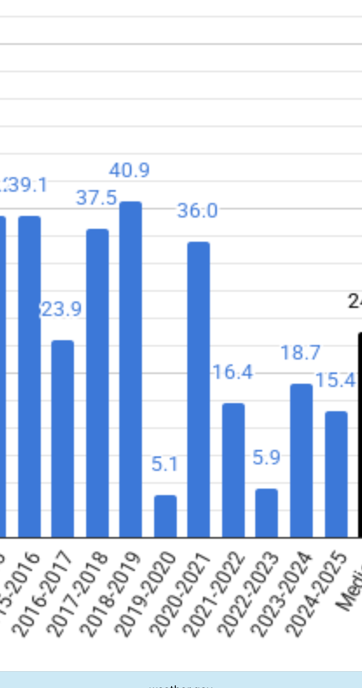
ABC-27 just showed on their news some information in regard to our local Winter weather. They had a graphic that said 8 of the last 10 Winters had below normal snowfall. I’m assuming they are using MDT stats. CTP is showing that only 6 of the last 10 Winter seasons had below normal snow at MDT. Maybe they are only using Dec to Feb which could skew it by not including November & March/April snow? Below are the official seasonal numbers from CTP’s website for MDT seasonal snow for the last 10 seasons.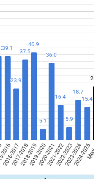
-
Central PA Winter 25/26 Discussion and Obs
Blizzard of 93 replied to MAG5035's topic in Upstate New York/Pennsylvania
My temp is still 32. Icy Winter wonderland out there is showing beautiful scenery. -
Central PA Winter 25/26 Discussion and Obs
Blizzard of 93 replied to MAG5035's topic in Upstate New York/Pennsylvania
Models continue to look active with chances during the first 10 days of January. -
Central PA Winter 25/26 Discussion and Obs
Blizzard of 93 replied to MAG5035's topic in Upstate New York/Pennsylvania
Sleet covered roads at least make it look more wintry. Looks to be about half an inch of sleet out there on top of a glaze of freezing rain. Freezing drizzle later should make this a real treat to remove in the morning from the sidewalk. -
Central PA Winter 25/26 Discussion and Obs
Blizzard of 93 replied to MAG5035's topic in Upstate New York/Pennsylvania
Puking sleet right in Marysville now after a period a freezing rain. Absolute skating rink out there now. Temp 27 Dew point 24 -
Central PA Winter 25/26 Discussion and Obs
Blizzard of 93 replied to MAG5035's topic in Upstate New York/Pennsylvania
Heavier band looks to be approaching the western LSV in Adams, Cumberland & Perry on the march due east. -
Central PA Winter 25/26 Discussion and Obs
Blizzard of 93 replied to MAG5035's topic in Upstate New York/Pennsylvania
Sleet & Freezing rain mix to start in Marysville transitioned to moderate sleet. The cars are already encrusted in Ice & getting sleet covered. Temp 28 Dew point 20