Blizzard of 93
-
Posts
13,069 -
Joined
-
Last visited
Content Type
Profiles
Blogs
Forums
American Weather
Media Demo
Store
Gallery
Everything posted by Blizzard of 93
-
Central PA Winter 25/26 Discussion and Obs
Blizzard of 93 replied to MAG5035's topic in Upstate New York/Pennsylvania
Kuchera NAM -
Central PA Winter 25/26 Discussion and Obs
Blizzard of 93 replied to MAG5035's topic in Upstate New York/Pennsylvania
Just about done at 10 am Monday -
Central PA Winter 25/26 Discussion and Obs
Blizzard of 93 replied to MAG5035's topic in Upstate New York/Pennsylvania
Over 10 inches in Harrisburg by 7 am Monday & near 18 in Lanco & it’s still not done! -
Central PA Winter 25/26 Discussion and Obs
Blizzard of 93 replied to MAG5035's topic in Upstate New York/Pennsylvania
I like the large amount of member clusters near & west of the Op. If the 8 far east members are eliminated, the mean would be even more tucked. -
Central PA Winter 25/26 Discussion and Obs
Blizzard of 93 replied to MAG5035's topic in Upstate New York/Pennsylvania
Good post from @Heisy Here was eps, the black dot I made is where the OP was -
Central PA Winter 25/26 Discussion and Obs
Blizzard of 93 replied to MAG5035's topic in Upstate New York/Pennsylvania
This is what I’ve been talking about that CTP mentioned in our Warning ADDITIONAL DETAILS...Uncertainty remains for where the heaviest snow bands will occur. Snow totals could be higher depending on these localized bands. Snowfall at times could exceed 1 inch per hour rates. -
Central PA Winter 25/26 Discussion and Obs
Blizzard of 93 replied to MAG5035's topic in Upstate New York/Pennsylvania
Winter Storm Warning URGENT - WINTER WEATHER MESSAGE National Weather Service State College PA 143 PM EST Sat Feb 21 2026 ...IMPACTFUL WINTER STORM TO BRING HEAVY SNOWFALL TO CENTRAL PENNSYLVANIA... PAZ057>059-064>066-221130- /O.UPG.KCTP.WS.A.0004.260222T1000Z-260223T1800Z/ /O.NEW.KCTP.WS.W.0002.260222T1000Z-260223T1800Z/ Dauphin-Schuylkill-Lebanon-Adams-York-Lancaster- Including the cities of Hershey, York, Pottsville, Lancaster, Lebanon, Gettysburg, and Harrisburg 143 PM EST Sat Feb 21 2026 ...WINTER STORM WARNING IN EFFECT FROM 5 AM SUNDAY TO 1 PM EST MONDAY... * WHAT...Heavy snow likely. Total snow accumulations between 6 and 12 inches possible. Winds could gust as high as 40 mph Sunday night and Monday. * WHERE...A portion of central Pennsylvania. * WHEN...From 5 AM Sunday to 1 PM EST Monday. * IMPACTS...The strong winds and weight of snow on tree limbs may down power lines and could cause sporadic power outages. Travel could be very difficult to impossible. The hazardous conditions could impact the Monday morning commute. * ADDITIONAL DETAILS...Uncertainty remains for where the heaviest snow bands will occur. Snow totals could be higher depending on these localized bands. Snowfall at times could exceed 1 inch per hour rates. PRECAUTIONARY/PREPAREDNESS ACTIONS... Persons are urged to stay indoors until conditions improve. If you must go outside, dress in layers. Several layers of clothes will keep you warmer than a single heavy coat. Cover exposed skin to reduce your risk of frostbite or hypothermia. Gloves, a scarf, and a hat will keep you from losing your body heat. Persons should consider delaying all travel. Motorists should use extreme caution if travel is absolutely necessary -
Central PA Winter 25/26 Discussion and Obs
Blizzard of 93 replied to MAG5035's topic in Upstate New York/Pennsylvania
Great to see that EPS trend! -
Central PA Winter 25/26 Discussion and Obs
Blizzard of 93 replied to MAG5035's topic in Upstate New York/Pennsylvania
Great post by @Jake Wx showing the Euro trend since yesterday. -
Central PA Winter 25/26 Discussion and Obs
Blizzard of 93 replied to MAG5035's topic in Upstate New York/Pennsylvania
From @MillvilleWx moments ago: ECMWF definitely folded and the 5H progression is great through 00z, then it kicks east-northeast instead of north-northeast like it should on the capture. It's coming into better alignment with other guidance like the GFS and hi-res. It's still a little too dry overall considering the setup, but it's a big shift in the grand scheme and a final fold to how this will materialize. QPF is going to be tough with this one. Our forecast should be on the website now and it's a very sharp gradient from Easton to DC with more east. It's plausible it's too light, but there will be adjustments tonight. Still a general 3-6" for a lot of the region with 5-10" across the M/D from Carroll on east. The norlun trough is a stripe of 6-10" now. That setup is delicate. Updated forecast will be out later. -
Central PA Winter 25/26 Discussion and Obs
Blizzard of 93 replied to MAG5035's topic in Upstate New York/Pennsylvania
Great to see the Euro juicing up towards game time. 12z top 6z bottom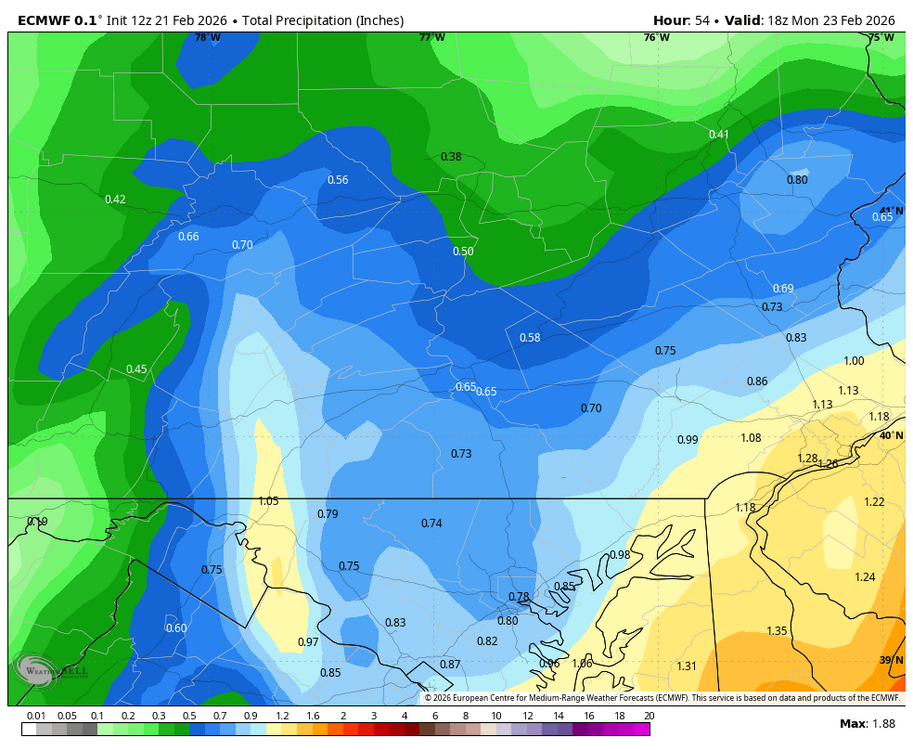
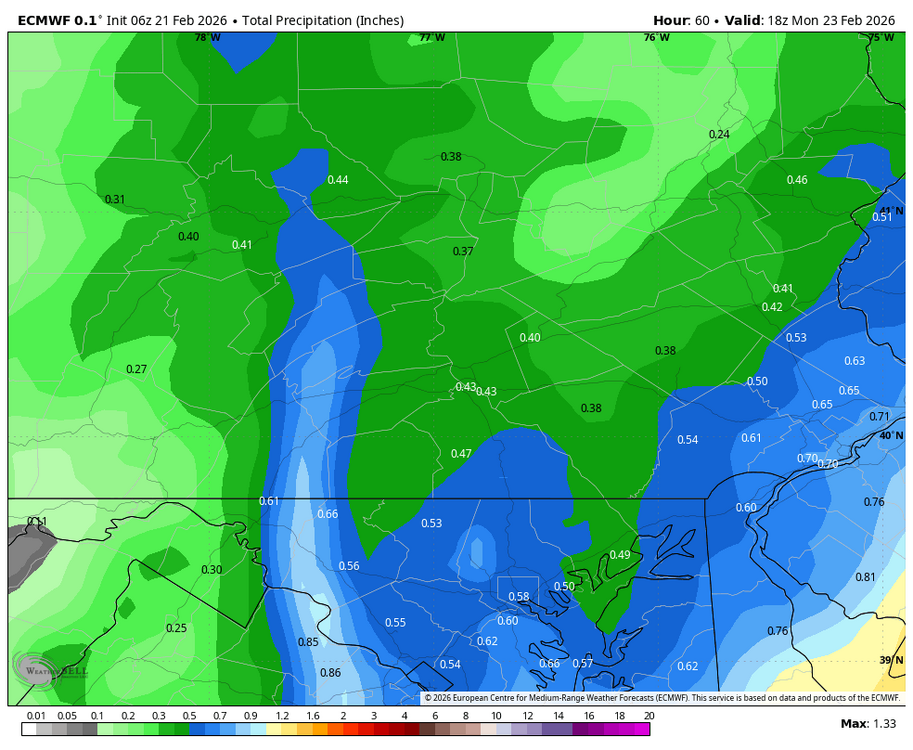
-
Central PA Winter 25/26 Discussion and Obs
Blizzard of 93 replied to MAG5035's topic in Upstate New York/Pennsylvania
I just brought my trash cans inside our fence. The combo of winds & plowed snow could have sent them into the river by Monday, lol! -
Central PA Winter 25/26 Discussion and Obs
Blizzard of 93 replied to MAG5035's topic in Upstate New York/Pennsylvania
Indeed, 12z Euro is more tucked & stronger when it matters for the LSV. Decent snow continues into Monday am as well. -
Central PA Winter 25/26 Discussion and Obs
Blizzard of 93 replied to MAG5035's topic in Upstate New York/Pennsylvania
The old school Euro + NAM combo for a good forecast could be in play ? -
Central PA Winter 25/26 Discussion and Obs
Blizzard of 93 replied to MAG5035's topic in Upstate New York/Pennsylvania
Here is the 15z NBM & 15z NBM Para. I would be thrilled with the range in the Harrisburg area of 7 to 11 if that verified. -
Central PA Winter 25/26 Discussion and Obs
Blizzard of 93 replied to MAG5035's topic in Upstate New York/Pennsylvania
Good post from @RU848789 in the NYC thread that includes the latest NBM & info on the snow ratio factors it uses. A few commnts on the NBM. Some think the high amounts are all due to the GFS/NAM being part of the blend and that's partly true, but snow ratios are also part of it as can be seen by just looking at the QPF vs. snowfall maps, as there's nowhere with >2.4" of QPF, but many locations getting >24" of snow even along the coast and inland with maybe 1.5" of QPF. The NBM table above says they use a combo of max temp aloft (Kuchera, I assume) and the Cobb method for generating ratios. So those 10:1 maps are likely underestimates. -
Central PA Winter 25/26 Discussion and Obs
Blizzard of 93 replied to MAG5035's topic in Upstate New York/Pennsylvania
Maybe the interstates, but secondary & back roads will be covered. Rates usually overcome borderline temperatures. We are still in February… -
Central PA Winter 25/26 Discussion and Obs
Blizzard of 93 replied to MAG5035's topic in Upstate New York/Pennsylvania
I’m sure they will be putting their updated Advisories & Warnings this afternoon. -
Central PA Winter 25/26 Discussion and Obs
Blizzard of 93 replied to MAG5035's topic in Upstate New York/Pennsylvania
The 12z short range models are showing what “should” happen with a deepening coastal low. Banding should push “well” inland similar to a tropical storm. There will also be a pivot point when the storm reaches & begins to pass our latitude to northeast. The backside of these events can be prolific as well if you get into a productive band. -
Central PA Winter 25/26 Discussion and Obs
Blizzard of 93 replied to MAG5035's topic in Upstate New York/Pennsylvania
We are under a freaking Winter Storm Watch, but the roads might not get covered, lol!!!!!!!!!!!! -
Central PA Winter 25/26 Discussion and Obs
Blizzard of 93 replied to MAG5035's topic in Upstate New York/Pennsylvania
The Deb doom casting is getting a little out of hand… -
Central PA Winter 25/26 Discussion and Obs
Blizzard of 93 replied to MAG5035's topic in Upstate New York/Pennsylvania
@GrandmasterB are we doing a MDT contest this time ? -
Central PA Winter 25/26 Discussion and Obs
Blizzard of 93 replied to MAG5035's topic in Upstate New York/Pennsylvania
From @MillvilleWx a few minutes ago: 500mb progression on the GFS is actually similar to the HRRR/RAP/NAMNest/NAM in terms of when the height fields close off and their general placements through 12z Monday. The GFS doesn't have anything beyond 09z Monday unless you're at the coast and drifts quickly to the northeast to limit additional snowfall which other models carry. I think it's cutting that off too quickly, and it also doesn't have the leading edge further north into the NW zones and the north-central portion of the sub-forum as it migrates the heaviest further south towards Rt50 and SoMD. I feel the initial is better handled by the rest of guidance. ECMWF is the furthest east, weakest, and driest. Unless is scores a major coup there, it's underdoing things too much, even if it had the "right" idea of being a bit further east. I am forecasting now and I can tell you I will not be using much EC deterministic, but more its ensemble blends to help with the forecast. What you see for the official WPC forecast is mine, so that will be what I think. I'll share when its online. -
Central PA Winter 25/26 Discussion and Obs
Blizzard of 93 replied to MAG5035's topic in Upstate New York/Pennsylvania
The GFS did its surprisingly good job bringing us to this point. Now the short range models must take us in the rest of the way. We are under 24 hours until game time. -
Central PA Winter 25/26 Discussion and Obs
Blizzard of 93 replied to MAG5035's topic in Upstate New York/Pennsylvania
No one knows where the good bands will set up tomorrow evening. I’ve seen storms like this get @MAG5035 into the good snow totals when he was supposed be somewhat fringed. There is often a second max area. Location TBD.