

Math/Met
-
Posts
291 -
Joined
-
Last visited
Content Type
Profiles
Blogs
Forums
American Weather
Media Demo
Store
Gallery
Everything posted by Math/Met
-
The mountain wave event has started at Camp Creek. Wind gusts currently around 70mph.
-
January 2021 Medium/Longterm Pattern Discussion.
Math/Met replied to AMZ8990's topic in Tennessee Valley
Mrx has issued a High Wind Watch for the mountain wave event this weekend. This looks like the best setup so far this season. It checks most of the boxes in terms of various parameters for Camp Creek (and other foothill locations) to get very strong gusts Saturday night and Sunday. -
How much downsloping effects the event will be a close call. Just after I posted that, the 03z run came in with an improvement in NE TN…with a slightly more easterly component (rather than perpendicular) over the mountains near Greene and Unicoi Co for example.
-
The HRRR in particular is showing a persistent SE flow at 850mb over the mountains. That would make it very difficult for temperatures to cooperate in many parts of the valley in a marginal situation. I hope that changes.
-
I'm not suggestion that the RAP will be correct, but it has a more defined inverted trough centered over the mountains in the early part of that loop. There are many factors to consider, but that's what caught my attention. If that happens, then that could be a major help for some areas.
-
It's great!
-
January 2021 Medium/Longterm Pattern Discussion.
Math/Met replied to AMZ8990's topic in Tennessee Valley
As currently modeled on the Euro, I have some downslope concerns for parts of East TN (particularly for my area) but that could change over the next couple days depending on the strength and position of the low at 850mb. It's not too bad, just something to keep an eye on. I do like that a bit of an inverted trough is showing up along the mountains leading up to the heaviest precipitation on the Euro. That can help in multiple ways. -
Christmas Eve/Christmas 2020 Arctic Express Snow Obs.
Math/Met replied to John1122's topic in Tennessee Valley
Ended up with 5.5 after that last band this afternoon. -
Christmas Eve/Christmas 2020 Arctic Express Snow Obs.
Math/Met replied to John1122's topic in Tennessee Valley
Heavy snow band moving through Greeneville at the moment. Any melted areas on my road are completely covered again. -
Christmas Eve/Christmas 2020 Arctic Express Snow Obs.
Math/Met replied to John1122's topic in Tennessee Valley
There was about 4 inches on the picnic table the last time I measured. I'm trying to remember if Greene County ever had a decent mountain wave event (75mph gusts this morning) and then had this much snow in the same day. Interesting day for sure. -
Christmas Eve/Christmas 2020 Arctic Express Snow Obs.
Math/Met replied to John1122's topic in Tennessee Valley
Good post by John about the DGZ. You can see the effects of the lowering DGZ starting to show up on radar. This allows for some of the low level instability and lift to extend into the DGZ, and helps to aid these bands. -
Dandridge Dollop 12/24/20 Storm Thread (Winter Wonderland)
Math/Met replied to AMZ8990's topic in Tennessee Valley
A quick update on the mountain wave event with this system. Camp Creek has gusted to around 70mph so far.- 847 replies
-
- 6
-

-

-
- cold temperatures
- snow
- (and 8 more)
-
Dandridge Dollop 12/24/20 Storm Thread (Winter Wonderland)
Math/Met replied to AMZ8990's topic in Tennessee Valley
Looking at the soundings after the initial band moves through, the 3km NAM soundings are extremely impressive over NE TN on the lingering snow. Snow growth layer drops very low, so terrain induced lift extends into DGZ. Very steep lapse rates extend through the DGZ (SFC CAPE of over 50 in some areas). This all suggests potential convective snow bands and very high snow ratio on the lingering snow by 03z and beyond. Probably 20:1 or better ratios after 03z with some of those snow bands. Those are always some of my favorite things to watch.- 847 replies
-
- 9
-
-
-
- cold temperatures
- snow
- (and 8 more)
-
Dandridge Dollop 12/24/20 Storm Thread (Winter Wonderland)
Math/Met replied to AMZ8990's topic in Tennessee Valley
I’m definitely following the mountain waves. It should be a pretty good event. Mountain waves and snow within a 24 hour period... I can’t ask for much better than that.- 847 replies
-
- 4
-
-
-
- cold temperatures
- snow
- (and 8 more)
-
Oak Moon Upslope/ Upper Low Storm Obs
Math/Met replied to Holston_River_Rambler's topic in Tennessee Valley
Just measured about 2.5 inches on my back deck in Greene County. By far the heaviest snow of the night is falling at the moment. Over .5 in the last 30 minutes. Edit: This band is really impressive. Probably right at 3 inches by the time I'm posting this image.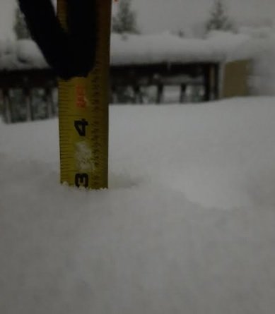
- 300 replies
-
- 7
-
-
-
- upslope snow
- upper level disturbance
- (and 3 more)
-
TN valley heavy rain/flooding week of whenever
Math/Met replied to janetjanet998's topic in Tennessee Valley
Glad they did quality control and straightened that out. Are they saying 81mph was the peak gust today? Just wondering because it looked like there were legitimate gusts in the mid to upper 80's based on the plot. Not that it really matters at this point, just wondering if all recorded gusts were higher than actual winds. -
TN valley heavy rain/flooding week of whenever
Math/Met replied to janetjanet998's topic in Tennessee Valley
I don’t want to post too much about the mountain wave event, but here is why I think the red data plots are incorrect. If you expand out to a 720 hour plot, you can see errors show up several times. The peak (green) is usually very accurate.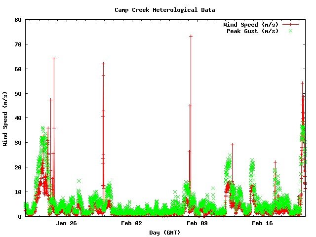
-
TN valley heavy rain/flooding week of whenever
Math/Met replied to janetjanet998's topic in Tennessee Valley
I haven't heard any major damage reports, but it looks like there are a lot of trees down in southern Greene County. WCYB Probably not the best idea to be standing there. -
TN valley heavy rain/flooding week of whenever
Math/Met replied to janetjanet998's topic in Tennessee Valley
That’s unfortunate. It may end up being correct, but I would be VERY surprised. The near 90mph gusts seem legit. I have a full dataset for research purposes that goes back to 2008, and 123mph would be way above anything recorded there. I do think it’s possible for Camp Creek to gust over 100mph in mountain wave events. I’ve speculated that it was over 100mph in 2004, but there was no reliable data at that point. -
TN valley heavy rain/flooding week of whenever
Math/Met replied to janetjanet998's topic in Tennessee Valley
https://oculus.atdd.noaa.gov/campcreek/ -
TN valley heavy rain/flooding week of whenever
Math/Met replied to janetjanet998's topic in Tennessee Valley
I think you are correct to ignore the red data on that chart. It is unreliable. The peak gust data (green) is probably accurate, so nearly 90mph. -
TN valley heavy rain/flooding week of whenever
Math/Met replied to janetjanet998's topic in Tennessee Valley
About 30 minutes after posting that, Camp Creek switched to a SE wind and gusted to 53mph. It should continue to increase. -
TN valley heavy rain/flooding week of whenever
Math/Met replied to janetjanet998's topic in Tennessee Valley
Everything still looks on track for a significant mountain wave wind event. It has taken awhile for conditions to become favorable. Even though VWP indicates 40kt SE winds at 4000ft, the cross barrier flow remains blocked. Camp Creek winds haven't really increased yet and aren't currently blowing from a SE direction. Conditions become much more favorable in the next few hours. HRRR is showing the enhancement right along the mountains and especially in the Camp Creek area by tomorrow morning. That's not the most reliable wind product, but it usually does a good job of showing areas of mountain wave enhancement (even if wind speed isn't accurate). The biggest question for me is how trees will hold up in areas with possible 75+ mph wind gusts and saturated soil.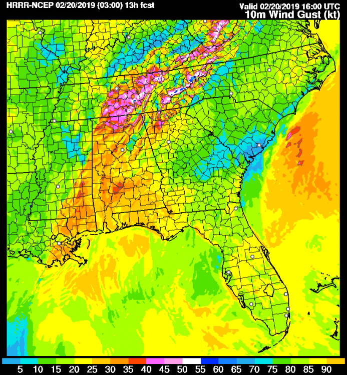
-
TN valley heavy rain/flooding week of whenever
Math/Met replied to janetjanet998's topic in Tennessee Valley
Favorable conditions for mountain waves will be in place later tonight and especially tomorrow morning. MRX issued a High Wind Warning and mentioned the potential for downed trees due to saturated ground in the AFD. It could take a few hours for mountain waves to really get going tonight/tomorrow morning. Models show a very strong temperature inversion across the mountains later tonight and the 850mb flow has a bit for of an easterly component. So, it could take until early tomorrow morning to get the proper balance between cross barrier wind speed and stability (haven’t calculated the Froude number, just basing on past experience). The cross barrier flow could be partially blocked for part of the night and could prevent the downslope flow from being sustained. After the initial round of precip lifts north, the 850mb flow becomes more southerly and the temperature profile is more conducive. That’s when the conditions become very favorable for mountain waves. This could be a strong event, which will likely cause some problems with down trees along the mountains. -
TN valley heavy rain/flooding week of whenever
Math/Met replied to janetjanet998's topic in Tennessee Valley
In addition to the flooding threat, there could also be a mountain wave event Tuesday night into Wednesday as a strong LLJ develops over the region with a favorable wind profile. With the saturated ground, these strong winds along the mountains could cause some problems as well.
