Math/Met
-
Posts
291 -
Joined
-
Last visited
Content Type
Profiles
Blogs
Forums
American Weather
Media Demo
Store
Gallery
Everything posted by Math/Met
-
Weathernext seems about the same for our area as 06z.
-
Just now getting a chance to look. It looks like the 6z WeatherNext was a little better for our area.
-
Larger flakes at the moment. Roads are covered now.
- 618 replies
-
- 1
-

-
- observations
- obs thread
- (and 1 more)
-
Light snow in Greene County. A light dusting so far.
- 618 replies
-
- 4
-
-
- observations
- obs thread
- (and 1 more)
-
I couldn't really find any information about which level it was on, so just took a chance on the hobby. It's there.
-
Weathernext 2 is on StormVista hobby level.
-
I'll defer to Jeff's post on that. He is much more familiar with your area.
-
Not a ton of moisture to work with, but NAM soundings along the mountains and foothills actually look decent for a switch to some light snow starting late tonight/early morning after the 850mb temps drop below -10C. DGZ basically just above the surface and inversion potentially trapping moisture.
- 618 replies
-
- 7
-
-

-
- observations
- obs thread
- (and 1 more)
-
My curiosity got the best of me. Just subscribed to StormVista for the first time.
-
Camp Creek currently has northerly light winds. Places near Cedar Creek are reporting gusts to around 20mph from the southeast. This is what would expect when the downslope wind is essentially blocked at Camp Creek and southeasterly winds are spilling into southwestern Greene County through the gap. Would expect CC winds to turn SE and increase as the LLJ lifts farther north.
- 618 replies
-
- 5
-
-
-
- observations
- obs thread
- (and 1 more)
-
That was an incredible snowstorm. It's hard to even explain to people how hard it snowed for a relatively short period of time. Wish I had video from that.
-
Also, I want to clear up any confusion since there has been some speculation. I don't work for MRX. They have done much better job in recent years on mountain waves, so credit goes to them on those discussions.
-
I hate I missed this discussion earlier. I love these terrain related topics and good contributions by everyone. I'm not going to pretend to know exactly what the models might be showing there. I will say that there are times during CAD situations where the southeasterly flow gets blocked at Camp Creek. The surface wind can stay light and even northerly at the surface at the CC tower. At the same time, winds can be southeast at 20-30 mph in the Nolichuckey/St. James area (only a few miles away from CC) as flow gets squeezed through the French Broad River valley. So not mountain waves in that situation, but air trying to take the path of least resistance. This typically occurs when the LLJ builds in from the south and the core of strongest winds stay mostly south of the area. It definitely happens, but I've never actually noticed a drop in temperature from it...because there is still a bit of downslope involved as air leaves the gap. Guess that's a long way of saying that I really don't know how that will work out compared to what the hi-res models show. Will be interesting to watch though.
-
When it lifts that far north, the 850mb winds not only brings the surge of warm air but probably a downslope component for our area.
-
Definitely not what I wanted to see. Hopefully we can trend back the other way with time, but we've definitely seen this play out like that several times.
-
After a very quick glance, looks like the AIFS took another step in the right direction.
-
This is the most important trend for me today. Need to keep that southerly 850mb flow south of us. Hopefully the AIFS continues that trend.
-
I haven't logged in for a long time. Figured this might be a good time. Hope everyone is doing well.
-
Currently the heaviest snow of the event under one of those bands. Bigger flakes too.
-
You can tell on radar that low level instability has increased over the past couple of hours. More distinct bands.
-
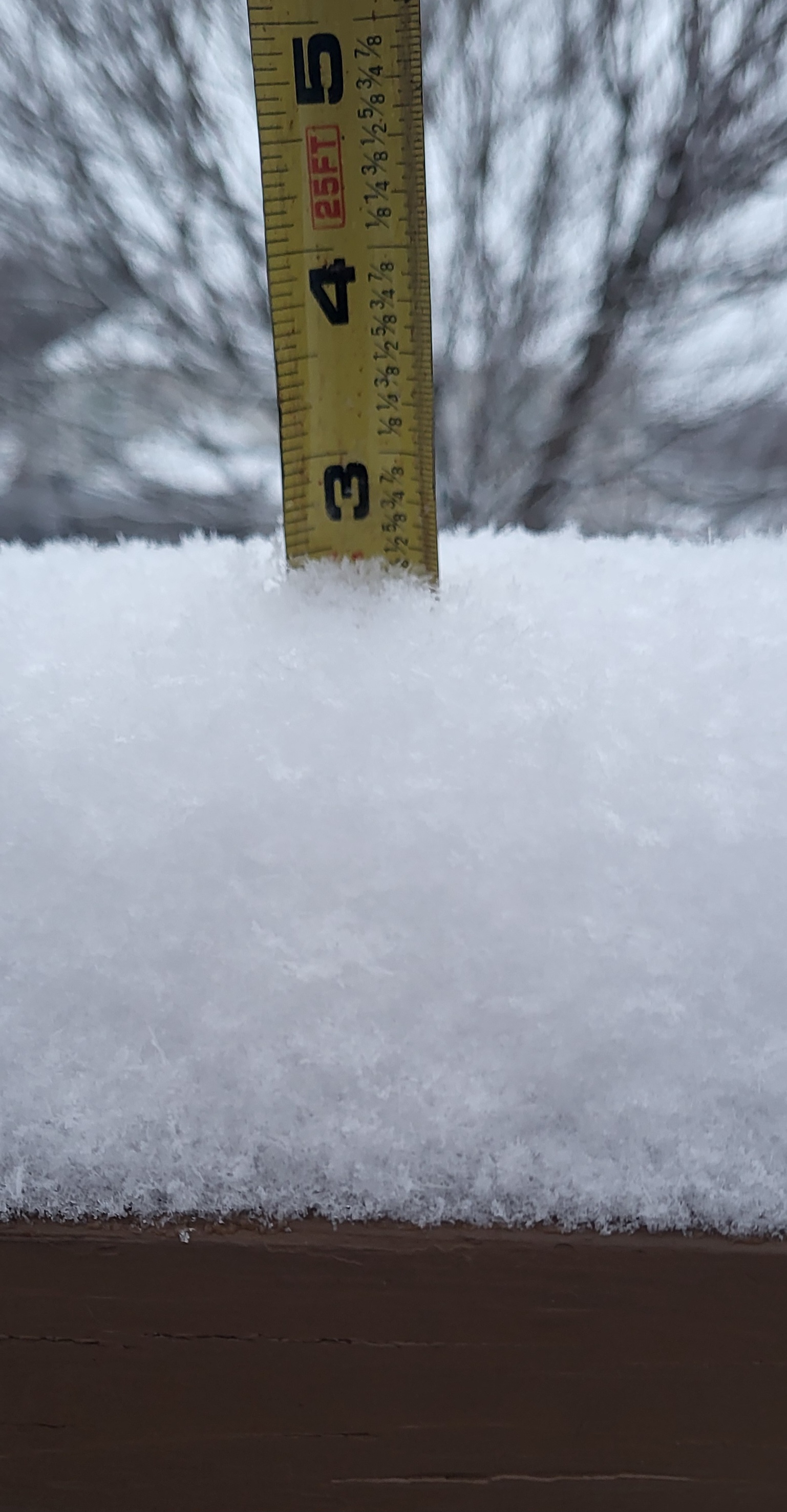
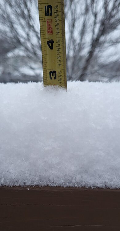
Similar rates here. I have just over 3 inches of accumulation now, so about .5 inch increase in about 45 minutes.
-
Not bad. Still snowing and continuing to accumulate.
-
Snow has picked up in Greene Co. Most of the snow from earlier today melted, but it's starting to accumulate again now.
-
I like to use short range models to monitor when 850mb temps of -10 to -12C get advected into the area. The radar usually start to fill in when that happens. Just have to know how your area does in these situations.
-
Model soundings later tonight (after about 09z in my area) make me optimistic too. Good saturation/depth in the DGZ. The DGZ dropping below 850mb usually helps and steep lapse rates extend into the snow growth layer. There's definitely potential for some areas to overperform under these high ratio bands.