
BlueRidgeFolklore
-
Posts
725 -
Joined
-
Last visited
Content Type
Profiles
Blogs
Forums
American Weather
Media Demo
Store
Gallery
Posts posted by BlueRidgeFolklore
-
-
33 in Hendersonville where I work. Snowing hard, not sticking yet.
-
2 minutes ago, wncsnow said:
Raysweather with one of the worst forecasts I have seen on Facebook... He is usually better than that
He’s mad because the high country isn’t the epicenter. Lol.
-
 1
1
-
-
5 minutes ago, snowbird1230 said:
GSP not impressed at all..The only warnings in the south are in East Tennessee..lol
They’re gun shy on hyping winter weather after all their busts in the upstate. We really need a different representative for the 828.
-
 2
2
-
-
3 minutes ago, AsheCounty48 said:
Well, Ward went somewhat gung-ho with his call. I like it.
He’s been on top of this from the start. He said last week that he loved this setup and it’s setting up. He said 3 days ago that these models would correct to a more northern solution with their precip and they did. He said 2 days ago that he liked the NAM and GFS over the Euro, and low and behold did the Euro cave.
Hunter has been all over this thing and I’m riding his call map into the sunset. Lol.
-
4
-
-
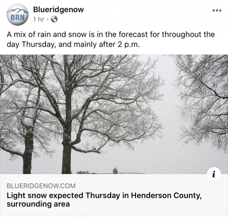
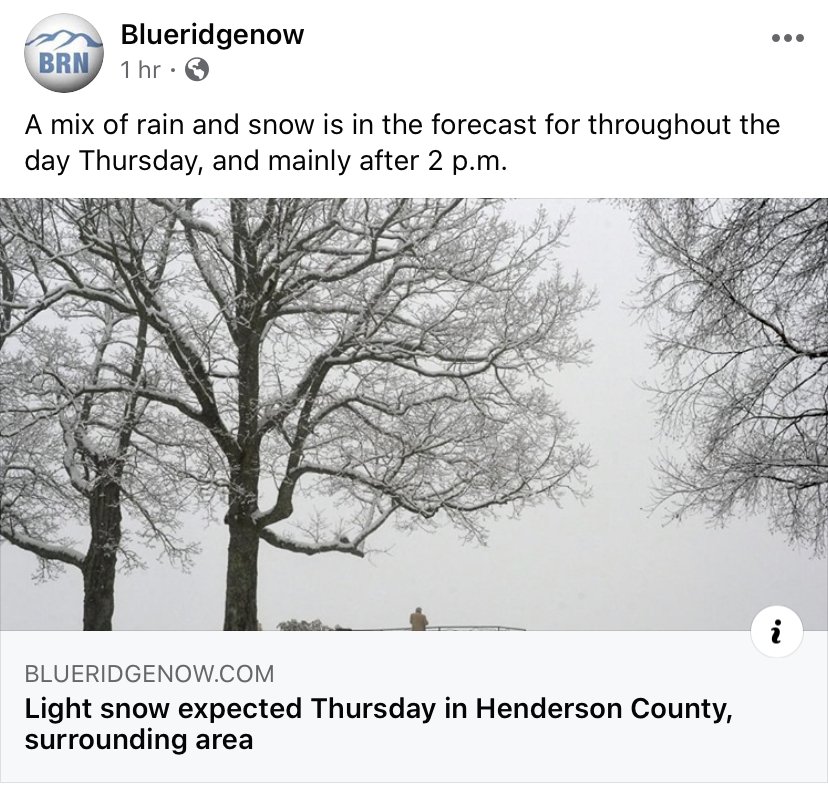
The Hendersonville paper has been listening to too much Jason Boyer.
-
3 minutes ago, Sw NC weather said:
That was close to a huge run 1” plus precip was not far one more shift and we might be in for a real pasting.
Fo’real. We could be in for a real surprise.
-
NAM came in juicy and pasted the southern mountains. Slightly warmer but doesn’t look to be an issue here.
-
1
-
-
Just now, Blue_Ridge_Escarpment said:


Give me that mean all day!
-
3
-
-
19 minutes ago, wncsnow said:
I have butted heads with him before on social media. One storm in 2014 he called for a half an inch in Marion and we had 2 inches by the time he put out the graphic. Forecasting on social media isn't easy by no means but he has a way of rubbing people the wrong way at times. Brad P too.
Boy do I wish Bob Caldwell had social media when he was forecasting.

-
1
-
-
3 minutes ago, wncsnow said:
Poor Jason...he hardly ever gets it right and gets hammered on social media regularly.
I quit following his social media pages. He's the most ho hum meteorologist I have seen and is nearly always a day late and dollar short. At least Chris Justus acts like he gives a damn.
-
2
-
-
This is gonna be good.
-
2
-
-
Our very own came out with his first call map. It's bullish. I like bullish.
-
3
-
-
-
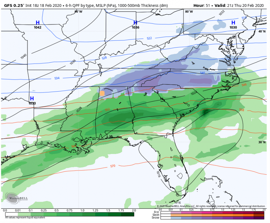
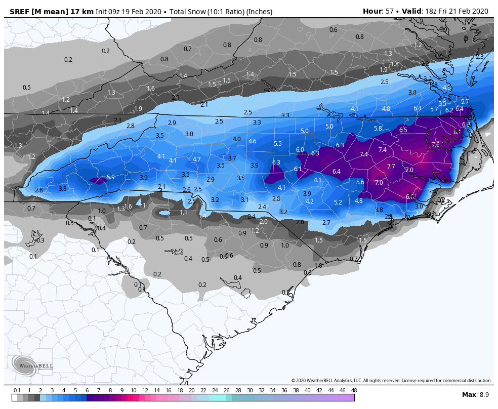
The GFS has caved with the precip much farther north.
Kudos to @Hvward, he was on point yesterday in saying that the models would struggle with the northern periphery of moisture.
-
2
-
-
This would be a nice thump!
-
3
-
-
12 minutes ago, Hvward said:
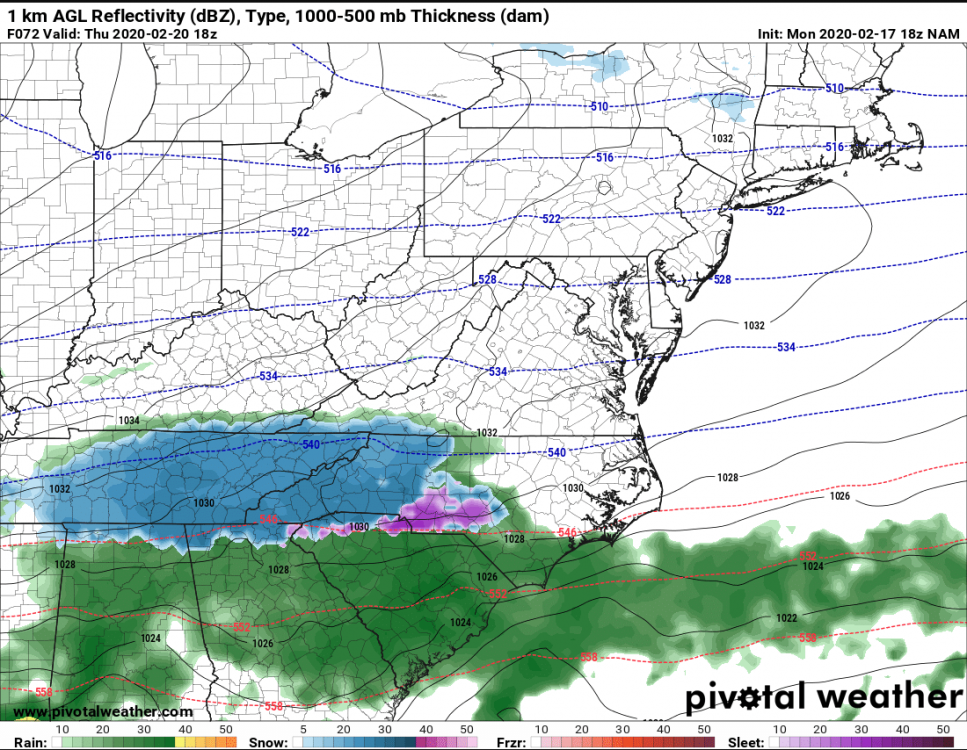
12z nam still has the strip of precip over WNC. Small details though are going to be huge with this system.
I am going to heed your own advice from yesterday: Models tend to under-do that northern periphery of moisture and its extent.
We've been here and time and time again and more times than not will the precipitation field trend further north than is currently being shown.
-
2
-
-
2 minutes ago, Hvward said:
We just need the moisture.
Who'da thunk it would come down to this?
-
1
-
-
9 minutes ago, nrgjeff said:
ECMWF looks good overnight, though typical Day 4 caveats are in effect. Other models agree somewhat, even if the GFS loses the system some runs. NAM appears to have it.
High press remains firm for the cold air. System tracking to the south, originating from Texas, my favorite for sliders / non-cutters. Northern stream appears to prevent any cut, if the HP wasn’t already enough. 700 mb temps look great for the Mountains.
Lower elevations (Sanitarium) have boundary layer temp issues. Mountains should be fine, in fact at/below freezing above 3,000 FT. Starting late last week, better late than never!

All the pieces are there, this will be fun to nail down the specifics. What are your thoughts on orographic uplifting along the southern escarpment? I've seen @Rainforrest cash in with setups like this.
-
1
-
-
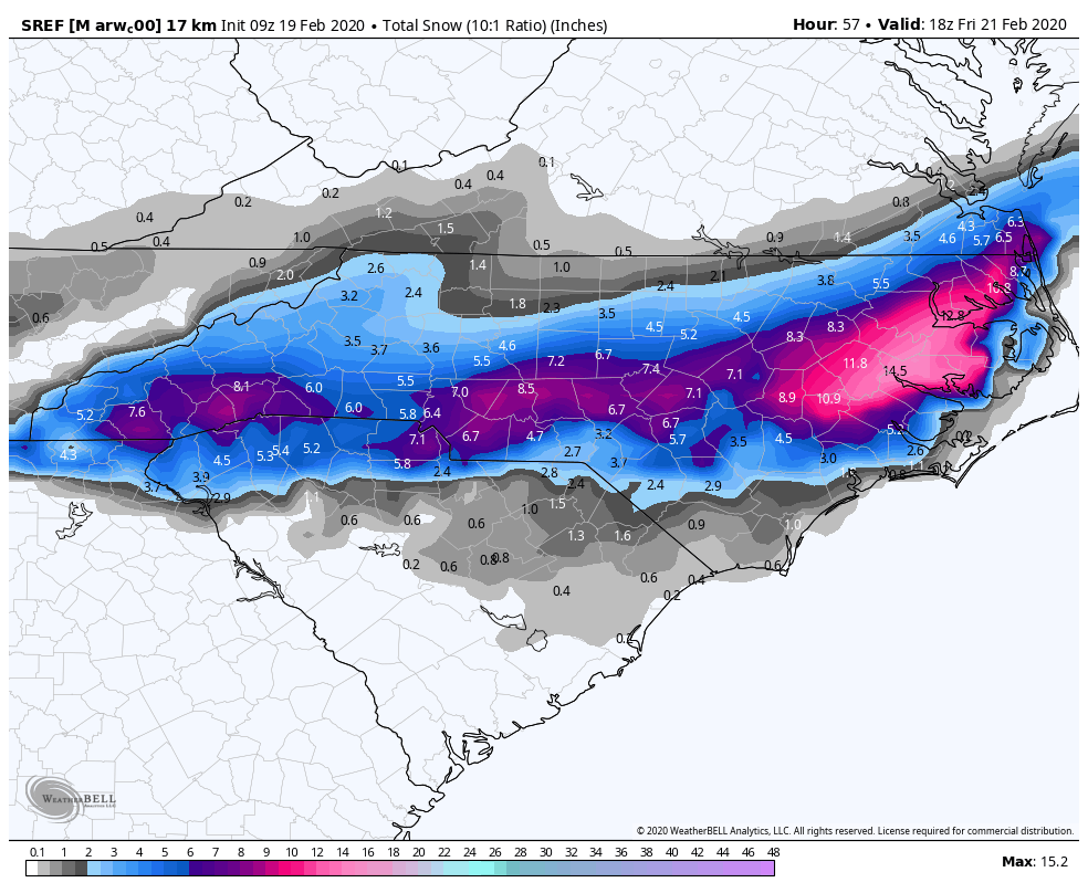
Euro with a huge northern shift with the precip. This storm should now have all of our attention.
-
6 hours ago, Blue_Ridge_Escarpment said:
Also, interesting fact that Hot Springs is a lower elevation than Marion, over in McDowell county.
A lot of folks also don't realize that Hendersonville is actually higher in elevation than Asheville, Sylva, Marshall, Bryson City and Cherokee and we tend to not associate it as much with it's relative elevation like we do the others.
-
On 2/9/2020 at 8:12 PM, calculus1 said:
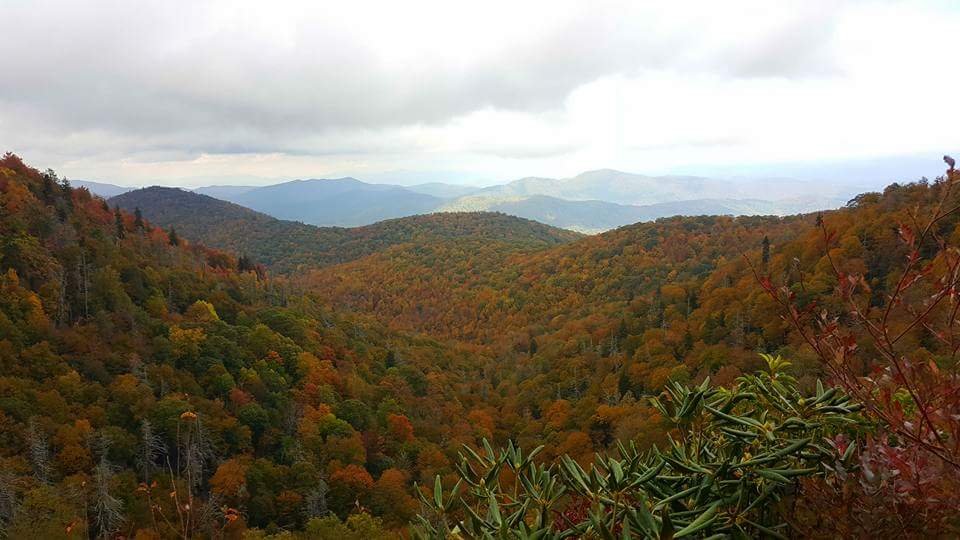
Closer view of mountain counties. Just amazing the differences in only 50 miles from Asheville to Lake Toxaway:

Sent from my moto e5 supra using Tapatalk
Yep, French Broad River Valley from AVL to Hot Springs gets rain shadowed from the south.
-
53 minutes ago, AsheCounty48 said:
It's been ugly like this all winter, we're used to this lol.
Fo'real. This aint nothing new.
-
1
-
-
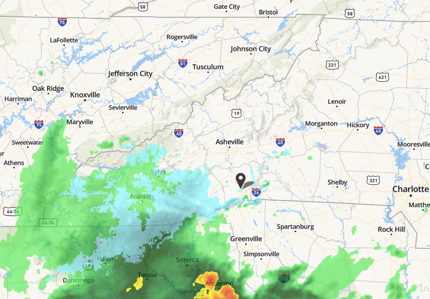
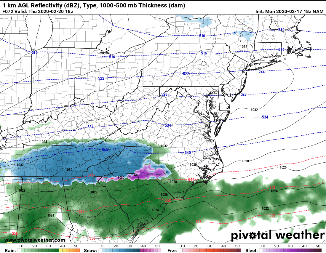
If radar is to be trusted......
-
39 minutes ago, BhamParker said:
I am extremely nervous being on the western edge of the precip. Hoping Haywood county will do okay, but it sure would be nice for things to trend further west as we get closer to verification. We should be rolling into town around 3 tomorrow!
Looks to be hugging CAD areas and Haywood is not the place to see a good CAD setup. Just my gut, but I doubt this trends west.
2019/2020 Mountains and Foothills Fall/Winter Thread.
in Southeastern States
Posted
His forecast is now in line with nearly everyone else's. Quit being such a contrarian and sit this one out.