
BlueRidgeFolklore
-
Posts
725 -
Joined
-
Last visited
Content Type
Profiles
Blogs
Forums
American Weather
Media Demo
Store
Gallery
Posts posted by BlueRidgeFolklore
-
-
18 minutes ago, HurricaneTracker said:
This is a big deal given the horrid 12Z NAM run we saw. Just verifies to me that the 12Z run was junk.
EDIT: also suggests the NAM will correct itself at 18Z
As it appears, the 18z is in fact correcting itself. Right on the money again HT!
1 minute ago, BretWheatley said:This can't be right... ?
Are they drunk?
-
19 minutes ago, Rainforrest said:
Southern escarpment looks golden
The escarpment in general is looking great. I say in terms of inhabited areas (not Mt. Pisgah, or Mitchell), high elevations along the escarpment are going to see a boat load. Highlands, Sapphire, Balsam Grove, Bearwallow Mtn, and obviously going up into the Spruce Pine and Blowing Rock areas.
-
 1
1
-
-
9 minutes ago, chapelhillwx said:
Going to book a hotel room tonight -- Staying the night Saturday at my gf's house in Greenville (to see Hamilton, I wonder if it'll be canceled) and heading north first thing in the morning. Would y'all say Hendersonville, Asheville, or somewhere else that's relatively easy to get out of?
I'd say somewhere between the 2. Fletcher or Skyland, maybe somewhere around the airport. I say that only because Asheville proper can sometimes be prone to getting snowholed if warmer air travels down the FB River Valley from the NW. Honestly, if you can find an AirBNB around Bearwallow Mountain. I think that will be the SweetSpot!
-
1
-
-
I use 'tiebreaker' loosely. Better wording would likely be if the Euro looks good, do we toss the NAM for now?
-
Just now, HurricaneTracker said:
Really no reason not to trust it at the moment. It's been very consistent with this system and has better resolution than the current GFS. And yes, will go operational in January.
Thanks!

-
Ukie looks good too. So CMC, GFS, FV3, Ukie all look like good hits for WNC. NAM at the outer fringe of it's range does not. Euro will be the tiebreaker?
-
1
-
-
HT, quick question regarding the FV3. I know it's going to be operational in a few weeks and we'd might as well use it but how far do you trust it?
-
2 minutes ago, HurricaneTracker said:
Concur. and FV3 GFS (which by the way goes operational in January 2019...so why not use it....) has a MUCH better QPF response accordingly. I'm not dismissing this could be a 4-6" event, but it sure does seem like more is in the offing. We wait for 12Z Euro to confirm.
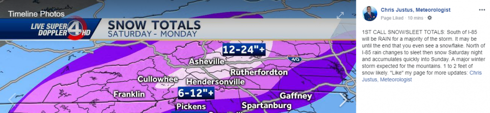
Look how JUICY!!!!
![[âIMG]](https://www.tropicaltidbits.com/analysis/models/fv3p/2018120612/fv3p_ref_frzn_eus_11.png)
-
2
-
-
2 minutes ago, BretWheatley said:
Mean for KAVL jumped from 16.58 to 20.01: http://www.emc.ncep.noaa.gov/gc_wmb/tdorian/gefs/EMCGEFSplumes.html
We're still dealing with a ton of moisture. I still like where we sit.
-
1
-
-
2 minutes ago, wncsnow said:
Yes but the way these models have been spitting out ridiculous amounts for days on end with ensemble means agreeing to a ridiculous extent.. it is disappointing if we get a typical storm instead of a blockbuster..
I'll agree if the QPF amounts continue to trend lower however one thing HT has stressed time and time again is not to hug snow totals on the models but rather look at QPF. If we're still dealing with 2-3" of moisture with any amount of CAD signature, after you factor in dynamic cooling, this is going to be a doozy. We also must factor in climo as well.
-
2
-
-
Freezing rain would definitely cut down accumulation totals in the Northern French Broad.

.thumb.png.6e403b87a86c02c8189c89796cd89ea0.png)
-
5 minutes ago, wncsnow said:
It's showing some freezing rain sneaking into the French Broad valley at 72 which will likely cut down on totals this run
Mainly from the nortwest where CAD has little effect. That's the snowhole in Madison County, N Asheville that we usually see with these storms.
-
Just now, AirNelson39 said:
Let’s hope this is just the NAM being the NAM. We really haven’t had any of the models “lose” the storm yet and we are around that 3 day window where we typically get some funky runs. Might as well be the NAM that does it.
That's where I find solace right now. If it were one of the global models, I'd have one foot over Looking Glass. However, it was the NAM.
-
1
-
-
Me after the NAM run:

-
1
-
-
4 minutes ago, McDowell_Weather said:
Id go to bursville higher elevation US 19 takes you to 26 within a few miles hard to beat for a higher elevation the french broad valley gets dry slotted too to me its worth driving 20 mins up the road to somewhere along 19 in the high country.
Generally with this setup, the French Broad River Valley only gets dry slotted around N AVL heading into Madison County. In Transylvania County heading into NW Henderson County, those people usually get hammered.
-
5 minutes ago, McDowell_Weather said:
The mix line will be closer to hwy 64 imho guna be a sleetfest for elevations below 2500 feet.
I'm going with 2000', right along the escarpment.
-
6 minutes ago, GunBlade said:
I have seen it a few times but not often. Nice thing is they aren’t pressured in a news room environment so they can put out what models show (conservatively still). Difference here is normally we don’t have so much model agreement so early. The storms normally gone until the day before. GSP is always on top of storms though and not afraid to show the possibilities. Always big kudos to them.
They were bullish for WNC in January 2016 storm but even then the totals crept up as we got closer. I don't think it's wishcasting to say these totals will go up when the Euro is showing 12" probabilities for KAVL at 100%. My gut just tells me based off experience, that these (for the Mountains only) are their conservative numbers.
-
17 minutes ago, Rainforrest said:
Looks about right for my location. Hoping for more though.
I have never seen GSP put out a map this bullish 3-4 days out. Heck, I'm not even sure the wave has been properly sampled yet. Rest assured this is a warning shot. These totals WILL go up for the mountains.
-
1
-
-
48 minutes ago, NavarreDon said:
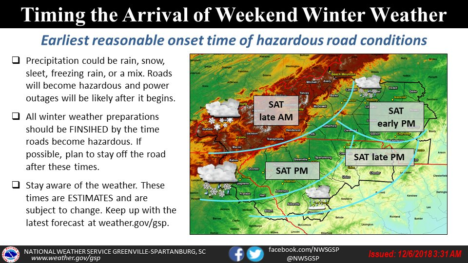
Interesting start times now with it being bumped up to Saturday AM. That aligns with what HT alluded to yesterday.
-
1
-
-
1 hour ago, HKY_WX said:
For the northern Foothills/Mountains, I think it's all systems go... My only concern for the central/southern Mountains/Foothills is whether sleet/zr mixes in and reduces totals significantly. Need to wait until we get w/in NAM range to pinpoint that. As far as SLP track, I still see this as more of a A/B hybrid type track. Wouldn't surprise me to see a renegade SLP pop a little further north on the SW corner of the wedge (Central GA/AL area???), which often happens as the STJ vort pushes east. And then jump to the southeast coast. Overall, something to keep in mind as well is if this vort can continue to trend more cutoff. That could generate some T-SN possibilities and more enhanced banding. I continue to Harken back to Dec 2002 and Feb 2004.
I don't foresee it being an issue for the central mountains as much as it will be for southwestern mountains. This is usually a favorable setup for the AVL, HVL area.
-
1 minute ago, BretWheatley said:
I’m torn between believing watching history unfold (weenie, I know) and still being extremely skeptical. Cheers!
15-18".
HT said so.

-
2
-
 2
2
-
-
5 minutes ago, HurricaneTracker said:
Dude, thanks! I am incredibly humbled that you’re willing to share my long *** write up with your family. I tried to make it light-hearted and witty. You know, share a little fun and excitement for a “generational” snow event. Sure do appreciate your support!
HT, that was an incredible write up.
-
1
-
-
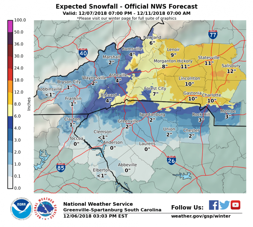
First, 'First Call' map I've seen.

-
2
-
-
Jason Boyer update is still sticking to 10-20+ for the majority of mountains outside the far southwestern portion.
-
2
-


December 8-10, 2018 Winter Storm
in Southeastern States
Posted
Heck, the NAM just showed a thump here.
There is no way that can be right. No way!