
BlueRidgeFolklore
-
Posts
725 -
Joined
-
Last visited
Content Type
Profiles
Blogs
Forums
American Weather
Media Demo
Store
Gallery
Posts posted by BlueRidgeFolklore
-
-
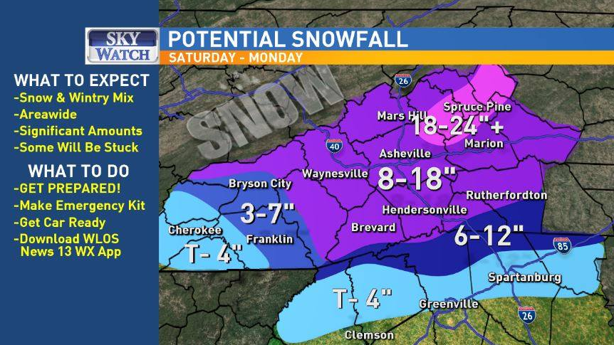
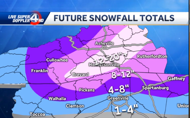
So WLOS backed off the totals a hair for the South/Central WNC, while WYFF upped the totals. Haha!
-
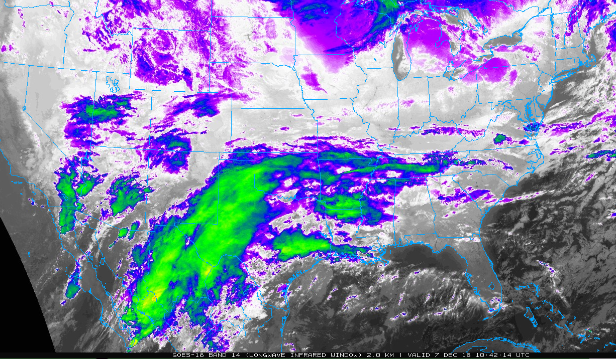
HT's fire hose:
-
 4
4
-
-
22 minutes ago, Met1985 said:
I'm back gang! Let's do this!
Heck yea, it's a party now!
-
2
-
-
00z is about to go boom it appears!
-
Listening to Jason's live video right now, you could tell he was caught off guard earlier by GSP and it made him a little uneasy. Now he's back to his guns and he's very confident. Feels only mixing will be an issue in SW mtns. Calling for huge totals in central and northern mtns.
-
2
-
-
22 minutes ago, jrips27 said:
Hey, y’all!
I am considering chasing this one in the Hendersonville/Flat Rock area. That area is the closest area to Atlanta (where I’ll be Saturday) that is consistently getting nailed on the models. I came in here to see if you guys had any suggestions or if you think that’s a good spot. Never been up that way before. Thinking of getting a cheap hotel for 2 nights somewhere right off I-26, which I’m sure is a main priority for those plowing.
Thanks for your insight in advance!
Upward Road off of I26 in Flat Rock. 3 new hotels, Cracker Barrel, etc.
-
1
-
-
1 minute ago, Tyler Penland said:2 minutes ago, AsheCounty48 said:To think that the FV3 and Euro are both showing close to the same solution... Makes you wonder.
Ukmet on board too, no? I didn't see the 12z cause I was slavin'.
Ukie and IIRC, the CMC as well. Someone correct me if I'm wrong.
-
4 minutes ago, Tyler Penland said:
Wowzers.

That. Is. Incredible.
-
2 minutes ago, HurricaneTracker said:
Finally looks like Euro
So do we toss GSP? Lol.
-
4 minutes ago, HurricaneTracker said:
Good evening everyone. I wanted to take a moment and give y’all an update in light of the disastrous communications issue that is unfolding before our eyes.
1. Overall things have NOT changed that much since this time yesterday. Euro came in with a swath of 20”+ from KAVL to KTNB and consistent liquid equivalents around 2.50”. Duly noted is that the Euro was NOT mentioned in the afternoon discussion by GSP. It has been absolutely rock solid on this storm system since last Saturday! To boot, we added the CMC model today with a lot of liquid equivalent, too. And now the 18Z FV3 (which we should all be looking at since it IS our future!), comes in with at least 2.00” of liquid (minimum QPF in Bristol, TN but that is expected given the setup).
2. 12Z NAM was a dumpster fire and has since corrected itself at 18Z (more corrections coming too, I suspect). 12Z GFS was a dumpster fire (just ridiculously low QPF) and p-type issues abound. Yet, this is the model of choice today by GSP. Oh but wait there’s more! 18Z GFS self-corrected and came in with more QPF and colder wedging solution. You want to hang your hat on the GFS? Better be ready to make more changes to the snowfall forecast as the GFS shifts.
3. Let’s talk warm nose. Does it exist? YES. Someone in the main thread said NE Georgia was out of the snow. I agree. This is climatology. Even parts of the favored escarpment areas will see sleet for a time being Sunday morning. What is confusing the models is the isothermal layer in the soundings. My eye sees the isothermal layer as a deep layer of snow, since dendrites will be falling into this isothermal layer. ALL MODELS say that even at 850mb temperature of 0.1 deg F this melts the flakes. I just completely and utterly disagree. In all my years of forecasting, deep isothermal layers that hover on the 0 deg isotherm (and are below freezing either side of this layer) tend to run as all snow. Watch for this in the next 24 hours.
4. Do we need to cut down snow amounts? Maybe. But don’t forget we are using a 7:1 ratio anyway to start with (see my post from yesterday). So instead of 2.50” of liquid coming out to 17.5” of cement, maybe we go 2.00” of liquid and 14” of snow. I’m currently most comfortable going with a range of 8-12” for KAVL and the eastern escarpment. Boone will see slightly more sleet because they are actually *too high* in elevation and above the wedge into the warm nose. So instead of 17” there, I think 8-12” also applies to them.
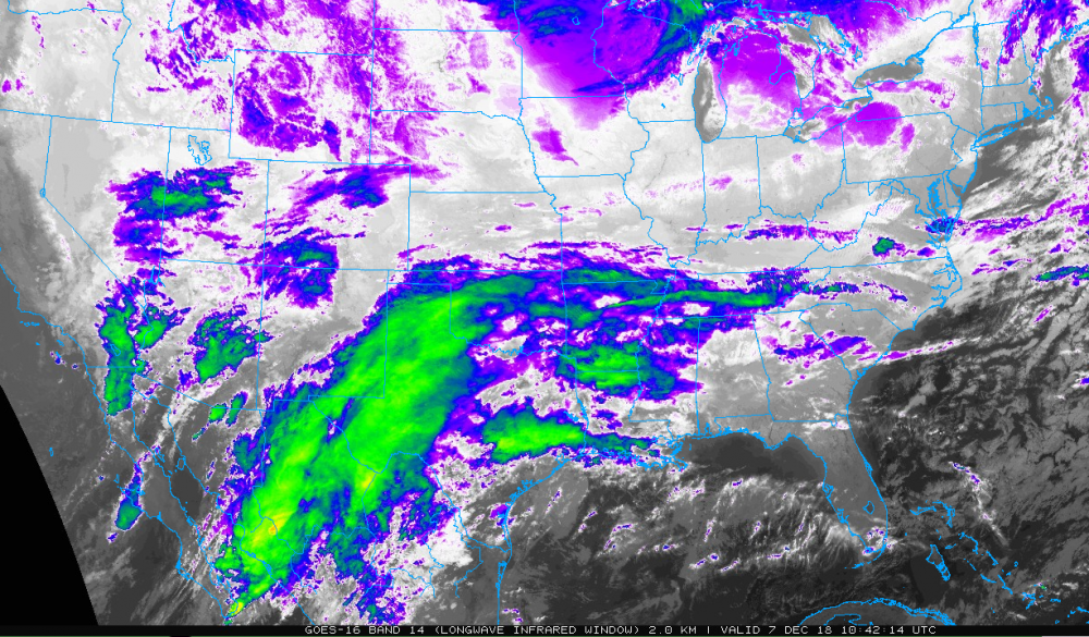
Hang in there folks. Watch the 00Z trends. Can’t ignore the intense dynamics and the fire hose that is our deep tropical moisture connection!
Once again, knocked it out of the park!
-
5 minutes ago, McDowell_Weather said:
I respect gsp but todays maps and disscussions could have been handled way better imo...
All joking aside, I completely agree. That was simply too much inconsistency and waffling on their part for an 8 hour period at this juncture. They should have at least waited until after the 18z. At least.
-
10 minutes ago, Blue_Ridge_Escarpment said:
Can GSP issue an emergency interim discussion after that 18Z suite of the GFS, NAM, and CMC?
I wouldn't even admit I pit that out on purpose.
I'd just come out and pretend it was by accident.
'Sorry folks, Phil spilled coffee on his keyboard.....'
-
1
-
-
12 minutes ago, BretWheatley said:
This is the most insane map I’ve ever seen... lmfao
That explains it. They didn't have enough time to look at the Euro because they spent all afternoon using MS Paint to make this catastrophe.
-
 4
4
-
-
Just now, wncsnow said:
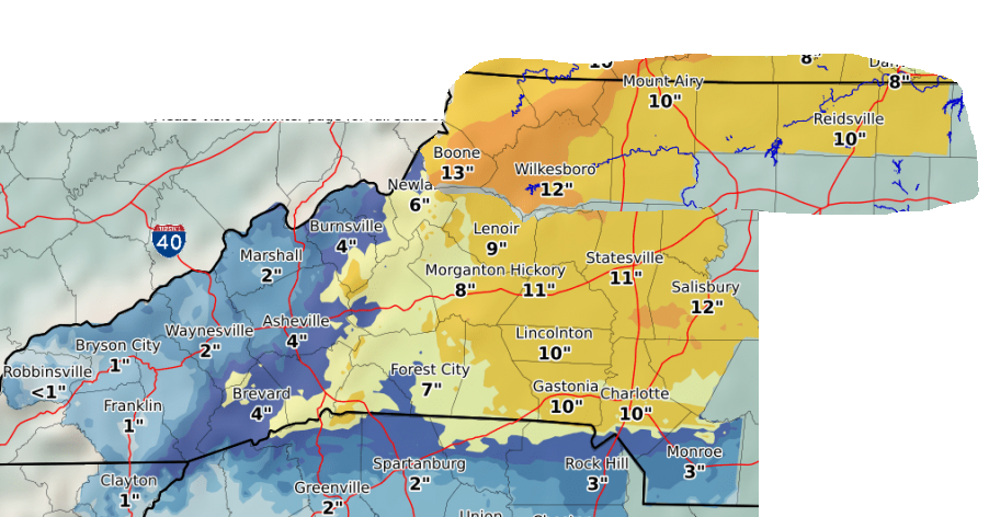
18Z GFS is pretty nice improvement. Over 9 inches in AVL so far with some sleet/ice on top
Great. That just means more GSP waffling.
-
Just now, SnoJoe said:
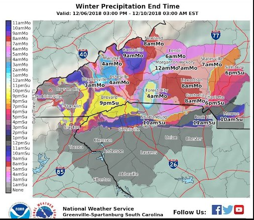
If GSP is expecting ice to cut into our snowfall accumulations, how was this map generated?

They said they're expecting sleet to cut our totals.
-
WTH is GSP doing?
-
1
-
-
Just for s***s and giggles, I superimposed the NWS Blacksburg's totals to align with where it meets GSP's. Somebody is way off!
-
1
-
-
Just now, BretWheatley said:
What gets me is that Charlotte is still sitting at 10 inches....
More than Mt. Mitchell. Lol....
-
1
-
1
-
-
Just now, HurricaneTracker said:
They based it off of the lower QPF values from the GFS. Didn't even look at or mention the Euro.
Didn't mention the Euro but changed their entire forecast based off the 1 model that won't outlive the snow mounds in the local Wal-Mart parking lot.
-
2
-
1
-
-
3 minutes ago, buncombe said:
It looks like they are expecting all the early precipitation fall as either rain or sleet in the Asheville area, thus drastically cutting totals. And they say they didn't even use the NAM for this forecast, so this must be based off GFS and Euro?
It's the GFS.
-
They should have waited until the 18z NAM ran......


.SHORT TERM /SATURDAY THROUGH MONDAY/...
As of 250 PM Thu: Still high confidence on the occurrence of a
winter storm developing late Saturday into early Sunday across
the region. Trends in the models unfortunately do not lend much
additional confidence to precip types or transitions. Cold-air
damming still is a key component of the event. The models suggest
the CAD will be a bit stronger at the onset of precip, which
looks most likely Saturday afternoon as a stationary front sets
up between the incoming continental sfc high and the developing
coastal low. The general track of the low is still expected to be
across the Coastal Plain to our south, so the timing of the event
has changed little.

One appreciable difference with this fcst package is lower
overall QPF. Unfortunately for the sake of forecasting p-type
distribution/transitions, models continue to show midlevel temps
flirting with 0C for much of the event. Temps are expected to
remain above freezing for most of the area Saturday afternoon,
though the trend has been colder in latest guidance. A deep but
relatively cool warm layer aloft implies a mix of precip types
is possible late Saturday; increasing precip should strengthen
the wedge through diabatic cooling and profiles will support all
snow over an increasing portion of WNC through Sunday morning. Sfc
temps Sunday are especially tricky given guidance split across
the freezing mark. Have biased the fcst in favor of a GFS-based
blend that did well in last month`s wintry wedge event. Still,
where temps are above freezing sleet is expected to be the main
p-type. The NAM is substantially warmer with temps aloft than
any of the global models we have at our disposal. For now the NAM
profiles are being discounted and not used in the fcst process,
not only due to the consensus in the other guidance, but to help
maintain better forecast continuity--i.e. not to shift too much of
the accumulation from the snow to ice category. But this is a trend
that we will have to monitor in subsequent fcst shifts. We continue
to expect 8-12" of snow over the climatologically coldest part of
the CWA during CAD, i.e., the east-facing Blue Ridge Escarpment
and area extending east along I-40. "Snow" totals have declined by
a few inches over the northern GA/SC zones and in the more western
NC mtns, as more of the QPF is now expected to fall as sleet. Ice
accums remain at least advisory criteria along the fringe of the
sleet area. Confidence is already high enough to warrant a Winter
Storm Watch for all of our NC zones; one is being hoisted with
this package. This is at least 12 hours earlier than we would
normally issue a watch. We thus have decided to leave out all the
GA/SC zones for now and perhaps try to better define the p-type
transition zone. The expected sleet/ice amounts in these zones
will be more sensitive to forecast QPF and therefore a downward
trend could keep some areas out of warning crtieria altogether,
thus not warranting a watch there. Stay tuned.

WAA continues, albeit more weakly, as the sfc low pushes out to sea
Sunday night. At that time we will begin a slow transition from the
CAD/Miller-A forcing to that supplied by a shortwave/deformation
zone transitioning over the area. PoPs decline very slowly thru
Monday as a result. With the WAA, whereas we might normally expect
a transition to all snow across the area, we will continue to see
mixed p-types toward the south and east, wherever sfc temps remain
near or below freezing. Moisture becomes more shallow during this
time, too, putting the possibility of additional snow/sleet in
question as ice nuclei become scarce.

Impacts from the combination of what is expected to be a very wet
snow, combined with icing in some areas, are not looking any less
significant than what the previous shift expected, even though
total amounts may have come down with this package. Very windy
conditions are expected Saturday night and most of Sunday, which
makes falling trees/powerlines likely.
-
7 minutes ago, Blue_Ridge_Escarpment said:
Somebody already hitting the eggnog in Greer.
I can't get over it. To me it also seems reckless.
-
3 minutes ago, WxKnurd said:
Just scrolled through their maps, the high end matches up with model output but then when you look at expected and then scroll through the “% of x inches”, it makes no sense why they went with what they did. only thing I can figure is they see this mainly a CAD region storm in regards to snow as the ice accumulation map is highest SW of Asheville.
They're showing more for Salisbury than atop Mt. Mitchell.
I'm sorry, but there is no on this earth that I am going to buy into that map right now.
-
2
-
1
-
-
4 minutes ago, wncsnow said:
Still early in the game its still possible. But I do HIGHLY doubt Charlotte will get 6 inches more than AVL
The main point is that there is ZERO guidance that even suggests it at this point.
2018/2019 Mountains and Foothills Fall/Winter Thread
in Southeastern States
Posted
Wow! So the NAM caves to the FV3. Can you imagine if the FV3 gets this correct?