
BlueRidgeFolklore
-
Posts
725 -
Joined
-
Last visited
Content Type
Profiles
Blogs
Forums
American Weather
Media Demo
Store
Gallery
Posts posted by BlueRidgeFolklore
-
-
Just now, Buckethead said:
I'm fine with that. I need to put a new exhaust system on my jeep anyway. Odds are that we'll cash in sooner or later, so we may as well enjoy it!
Exactly. It ebbs and flows, last 2 winters we had cold and snowy Decembers only to fail in January and February. I'd like to see a reversal for a change.
-
 1
1
-
-
4 hours ago, NGTim said:
the two things i read pretty much every day are Ray's weather and this thread, since i have so many good memories of trips up the high country. I think i might be overthinking it, but sometimes i get confused by the geographic markers in his forecasts, such as the 1) western ridge toward the TN state line, 2) the blue ridge, and then 3) the blue ridge escarpment. My guess is if i'm trying to draw a map is that 1) is just what it says, like maybe for example soco gap up to beech mountain area, and 2) is right along the blue ridge parkway, and 3), is further south and east toward the SC line?
If someone has a map that shows all 3 of these regions or lines i would appreciate it.
1) Is exactly what it says, the TN border area. The TN/NC line is always a wintertime jackpot in the South.
2) Not sure the context here but it could mean the parkway or WNC as a whole.
3) The escarpment is anywhere the mountains meet the flat land but when it's mention in the context of NC, it's referring to the eastern slopes where CAD is prominent.
-
 1
1
-
-
Anyone see the latest GFS and Euro runs? It’s time to get into tracking mode. We have something.
-
1
-
-
“I hear the weather is nice down south”
-
2
-
-
Throw an extra log in the fire.

-
1
-
 1
1
-
-
1 hour ago, Met1985 said:
I really like the pattern the euro is spitting out. Not concentrating on precipitation but the 500 pattern as a whole.
Agreed.
-
1
-
-
It’s good to see the usual faces showing back up in the mountain forum. Talking mountain weather with mountain folks is best, the other site with all their negativity is becoming unbearable.

-
2
-
-
17 minutes ago, Buckethead said:
12K name and GFS both suggest some backend flurries are possible in the favored border areas overnight Thursday into early Friday morning. And this weekend looks downright cold.
Yes sir. Winter is coming.
-
2
-
-
10 hours ago, SnoJoe said:
I agree. I think the last few years have shifted the bar a little. We forget what a nice leaf out is. This year isn't one.
I'll play the other side a little.
It's not that we have forgotten, it's just that in my mind those truly great color years aren't as frequent as we like to believe. At least not in my lifetime. 2015 was absolutely spectacular but it seems to be on par with how frequent we get those years.
-
1
-
-
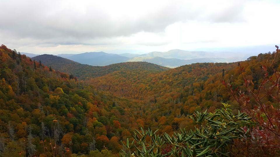
10 hours ago, eyewall said:
I made a return trip today and was let down. Lots of brownout and leaf drop along the Blue ridge from 421 to Linn Cove. There were pockets of good color but overall it was underwhelming. Seems like three bad years in a row. Lower elevations still haven't turned much either.
There must be a distinct difference between what you're seeing in the northern mountains and what's going on in the southern mountains. Down my way it looks fine, and according to WXKnurd, the Balsams look fine. However, the southern mtns are the rainiest region in the state, so even when in drought conditions, it's typically not as bad as it appears on paper.
-
3 hours ago, Buckethead said:
Clouds kept the view at my house (on the mountain the dslr is pointing at) obscured for most of today, but just a mile away it cleared up nicely! Turned out to be a really nice fall day with temps in the mid 50's. The leaf color is really beginning to accelerate down to 3000' up here.
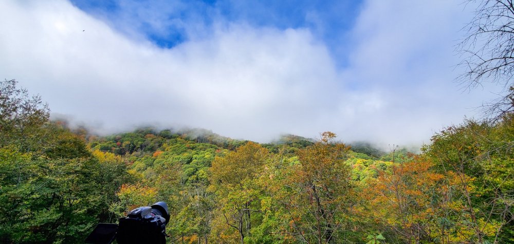
I tried to tell everyone that it wasn’t a bust. The color is progressing very nicely out my way.
-
49 minutes ago, Met1985 said:
Wooo! First 30s of the season! Had a beautiful low of 38 degrees this morning! Frost will be coming soon this week!
We hit 42 here this morning. It damn near took my breath away when I opened the door in a t-shirt and shorts at 6am.
-
2
-
-
3 hours ago, SnoJoe said:
Around here I think we are in trouble. Lots of brown patches and some trees are just shedding before any color. Last year was pretty horrible compared to the norm. We'll wait and see but just don't believe they're going to be all that pretty this year. Never seen a "delayed" peak season that was great. But as usual, there will be some areas that will have good color. If anyone is planning a trip up should get the local scoop from where they'll be.
Down here in Brevard, everything is still green and it’s still raining. I see no way it just browns out now. I think it’ll just be a delayed peak and I’ve seen some good ones every now and then...
-
2
-
-
3 hours ago, mackerel_sky said:
Peak probably Nov 1st or so. For the majority of the mountains! Drought and heat really hurting things this year
The mountains aren’t in as big of a drought as many believe. Everything is plenty green, we just need sustained cool nights.
-
1
-
-
58 minutes ago, eyewall said:
How is the foliage looking up there?
Better but still green. I think the colors will be fine just delayed.
-
2
-
-
Did anyone else notice this? I'll take our chances in the mountains for some of that cold in the NE to CAD it's way down the mountains and give us some overrunning events like we've had the last few winters.
https://www.accuweather.com/en/weather-news/accuweathers-2019-2020-us-winter-forecast/592125
While the Northeast braces for snow and cold, the Southeast is more likely to experience a wet couple of months.
Water temperatures from the Gulf of Mexico to the Southeast and mid-Atlantic coasts are running higher than normal, Pastelok said.
As storms move into the east early on in the season, the warm water could generate a significant amount of rain.
However, it’s not out of the question that the region could experience a winter storm, similar to last season, which brings snow or ice to areas like Winston-Salem, Charlotte or Asheville.
-
2 hours ago, magpiemaniac said:
Accuweather’s 2019-2020 winter “forecast” for the southeast US:
We’ll see I suppose.
I'll take those chances in the mountains most definitely.
-
1 hour ago, Tyler Penland said:
That photo is a little misleading imo. I'm in Boone and other than the occasional bright orange most of them are dull yellow.
3rd straight crappy foilage season coming I believe. A little rain could help salvage the rest but a lot of dead stuff already.
I don’t think so. Have a little faith!
https://wlos.com/news/local/photos-autumn-falls-into-color-at-grandfather-mountain
-
52 minutes ago, kvegas-wx said:
That looks like a brownout to me. A quick yellowing, then death. No way these trees stand a chance of much color this year. My yard is already full of dead leaves here in the Triad.
I don't think so. Typically in a brownout up here you don't get that vibrant orange on the tree and contrary to everywhere else, the mountains haven't been as dry as most. Yes we've been dry but not as bad as I saw driving through the Piedmont last week.
-
1
-
-
1 hour ago, eyewall said:
Any hints of the foliage starting up there yet?
It's coming!

-
3
-
-
Looks like we have gotten some agreement from the overnight models on some incoming fall weather next week. The first true fall front.
-
2
-
-
On 9/20/2019 at 3:29 PM, NRVwxfan. said:
Good luck getting anything on the SE coast with that stupid monster death ridge that refuses to leave like an obnoxious in-law.
SER be like.....

-
4 hours ago, Solak said:
I've always hated these maps. The passing eye would think 'scorcher' but in reality, a 30% probability is just as likely not to verify.
-
1 hour ago, griteater said:
Some numbers for the period of Sep 1 - Sep 17
Asheville: Avg Mean Temperature is 3rd hottest in 151 year record. Avg High Temperature is #1 hottest
Greenville-Spartanburg: 2nd hottest in 136 year record
Charlotte: 3rd hottest in 141 year record


Good stuff. It's interesting to see so many sequential years for AVL. Especially 1925, '26' 27.


2019/2020 Mountains and Foothills Fall/Winter Thread.
in Southeastern States
Posted
Is it Spring yet?