
BlueRidgeFolklore
-
Posts
725 -
Joined
-
Last visited
Content Type
Profiles
Blogs
Forums
American Weather
Media Demo
Store
Gallery
Posts posted by BlueRidgeFolklore
-
-
17 minutes ago, Tyler Penland said:39 minutes ago, BlueRidgeFolklore said:I have a feeling it will change. Honestly, this makes no sense with regard to warnings in N. Ga, yet watches literally right across the border in N.C. at HIGHER ELEVATIONS! Make it make sense?
Keep in mind there could be differences in what constitutes a WSW vs a WWA between the forecast offices. GA only requires something like 2" of snow in 12 hours for a WSW (maybe a little more, can't remember). I've had plenty of WWA events up here that would have been warnings back home in GA.
That could be it, but I thought the GSP had a uniform criteria for their area. Thanks for reminding me.
-
16 minutes ago, BretWx said:
Kind of surprised to see that. Especially parts of Henderson. I've got a few hundred feet on the town, fingers crossed! Need those clouds to start moving in.
Made it down to 22 at the house.
I have a feeling it will change. Honestly, this makes no sense with regard to warnings in N. Ga, yet watches literally right across the border in N.C. at HIGHER ELEVATIONS! Make it make sense?
-
 1
1
-
-
Jason basically taking the NWS stance. Lol.
https://www.facebook.com/jasonboyerweather/posts/249873693170758
-
 1
1
-
-
Former WLOS met:
-
1
-
-
Just now, BretWx said:
WSW just issued. Very odd range.
* WHAT...Heavy mixed precipitation possible. Total snow
  accumulations of 1 to 5 inches along with a light glaze of ice
  possible.

* WHERE...Much of the mountains, northern foothills, and northwest
  Piedmont of North Carolina.

* WHEN...From Thursday evening through Friday evening.

* IMPACTS...Travel could be very difficult. The hazardous
  conditions could impact the Friday morning commute.

PRECAUTIONARY/PREPAREDNESS ACTIONS...

Monitor the latest forecasts for updates on this situation.
That tells me they’re skeptical of the details right now but that they need to get it posted.
“Dusting to half a foot for 1/3rd of NC. Outside of that we’re really not sure.”
Lol.
-
1
-
2
-
-
1 hour ago, NavarreDon said:
Interesting! The exact opposite of the normal French Broad Valley moisture starved hole.
.Couldn’t save AVL though. Lol. being sandwiched between the Black and Balsam mountains makes it a desert, comparatively speaking.
-
1 hour ago, ncjoaquin said:
Normally conservative Jason Boyer WLOS throwing all his cards on the table for this one.
I was actually shocked to see it....
-
3 minutes ago, franklin NCwx said:
How far are you from where 281 forks in little Canada?
I can be in Balsam Grove in roughly 30min, Little Canada is further. I expect that area to do really good....
-
1
-
-
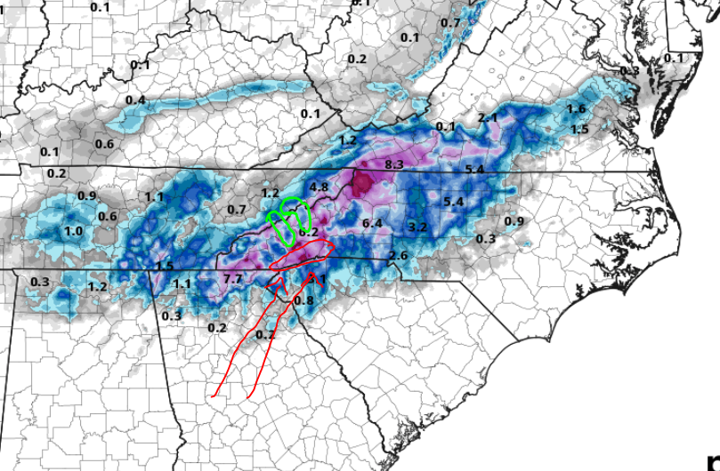
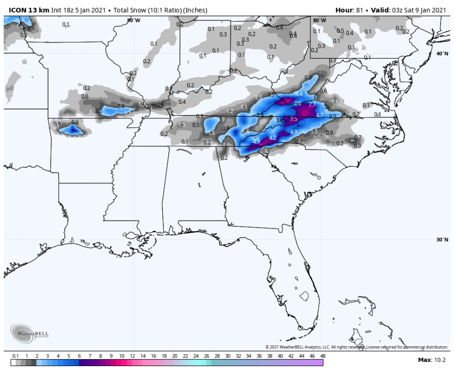
Looking at the Kuchera ratio is more realistic and personally, I feel is still too high, but I think the areas shown are the favored areas.
Red circle is the highest elevation along the southern escarpment and will wring out plenty of moisture. Green circles on the map are the French Broad River Valley and the Pigeon River Gorge. Asheville is notorious for being a victim of downsloping in this setup. It's the same reason why it tends to be the driest area in NC and Transylvania county the wettest. Those Balsam Mountains are just a bear to overcome.
-
1
-
-
4 minutes ago, Local Yokel Wx said:
@BlueRidgeFolklore, your spot is a tough call for us. Sort of a battle ground between elevation and higher precip rates. Are you up 276 at all (above the town's elevation of 2100')?
No I am not, that is all public land up 276 from my side of the Parkway. I haven't seen anything in the models to indicate that moisture or temp will be an issue in Transylvania. Obviously being higher helps. My expectations are not on the totals the models are spitting out but I do fully expect accumulating snow as the signal on the models is too strong to expect otherwise. The 64 corridor from Highlands to Hendersonville has consistently been shown as a good spot for this storm.
-
2
-
-
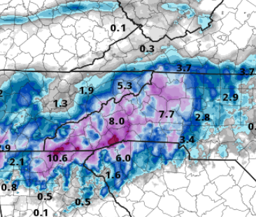
4 minutes ago, Met1985 said:
See this is what I don't understand is some of those holes in the SW mountains should be getting a lot more than it shows. Maybe something is up with the algorithm but this map looks off to me..
Not if this becomes a predominantly upslope/downslope compounded event. Not much different than we see with NWF and snow holes on the leeward side of the of the TN/NC line. I expect the southern escarpment and the higher peaks to wring out the most moisture, and for there to be some lower totals within.
I think some of the blue in Haywood County is due to downsloping from the Balsams from a storm of this setup.
We shall see but I don't see anything inherently glaring from the 3k map that says we should toss. I am not expecting a foot of snow in those favored areas, but I do think they are favored areas.
-
2
-
-
Just now, Met1985 said:
Im suspect anytime a models spits out huge numbers like that. Shoot how many times have we been burnt? I know I sound pessimistic but heck im as excited as yall are but I want to be sure of whats coming. Again no pipe dreams here only concrete meteorology.
While I agree, there has been a consistent storm signal for WNC. Amounts vary, but accumulating snow has been shown, run after run.......
-
1
-
-
3k NAM says someone better rent one of those yurts in DuPont....
-
2 hours ago, Met1985 said:
The overnight models dont really impress me with this storm. The GFS looks very moisture starved to me, the NAM looks decent and the euro has cut back on totals a lot. Again to me not good signs if you are looking for a big snow fellas.
Not a widespread even but could put up some locally high numbers along the southern mountains. I think areas like Balsam Gove could see upwards of 6".
-
1
-
-
2 minutes ago, AsheCounty48 said:

Headed to the bank to cash in.
The ICON looked good for the Southern Escarpment and NW mountains as well.
I'll be interested in seeing the 3km soon.......
-
10 minutes ago, Met1985 said:
The low just seems to be void of a really moisture wrapped system... This is why I said I would wait until Tuesday to really look at things. I've been down this road several times but the trends with the global models have not been great. Saying that we need to see how things play out and keep a level head.
Maybe so for some areas but I expect the southern escarpment will wring out some decent QPF with upsloping. Highlands to Hendersonville should do well.
-
4
-
-
6 minutes ago, BretWx said:
Through next Monday. Going to be a fun week.

Not sure this storm will put out a 10:1 ratio but it'll be a good thump nonetheless.
-
1
-
-
1 hour ago, Met1985 said:
Things do look up starting in about a week but lets get there first. This group is not about pipe dreams and unicorns. The pattern looks to really become active in about a week. We will go from there.
Yes sir, that's one thing I have always loved about the mountain thread over the years. No overhyping storms, no meltdowns, level heads just taking it for what it is.
-
5
-
-
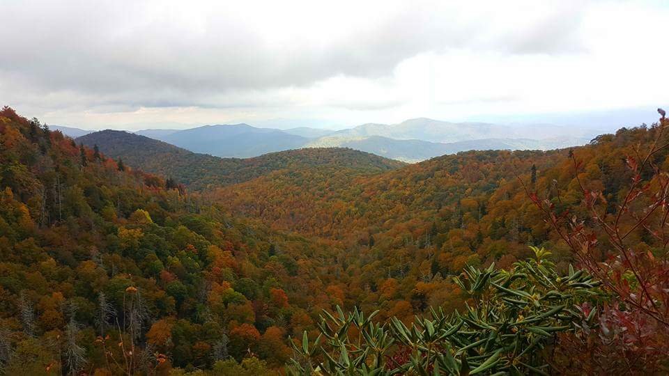
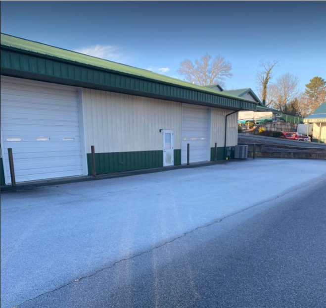
Heaviest frost of the year this morning down in Henderson County. Looked like a good dusting of snow when I first got up. I haven't seen frost lay this heavy on paved surfaces in a while. The roads were soaked from the melt off.
-
3
-
-
-
1 hour ago, Met1985 said:
Until the GFS jumps on it im not buying it from the EURO.
Needs more agreement, I agree.
-
1
-
-
30 minutes ago, WxKnurd said:
Been MIA because I forgot my login info. Y’all book it on a storm next week, I leave on the 30th and won’t get home from working in Louisiana until late the 7th. Was mid-20’s when I left the house at 5 this morning, right around 30 over in Mt Sterling when I got off the interstate. Probably ended up high 20’s over where I’m hunting, frosty morning that felt good. No deer were harmed though I did have one give me the slip,
Winter storm tracking brings everyone back like a good ol' fashioned homecoming.

-
4
-
-
54 minutes ago, SnoJoe said:
Same here. Opal was rough but the double shot of those two resulted in the worst damage I've seen with tropical leftovers. Frances flooded us and then Ivan blew the trees down just ten days later. The blowdown is still very evident across my property.
This is what always sticks out in my mind about those hurricanes.
-
4
-
-
57 minutes ago, Moonhowl said:
Glad Zeta from where I am sitting was not remotely as bad as Ivan or Opal and despite the very active season the mountains in general have not had the horrible tropical season that was in 2004.
Hopefully done with the tropics but not counting on it (something brewing out there now); looking forward to seeing some snow.
Happy Halloween
Frances and Ivan in '04 was an absolute mess up here!
-
3
-
2020/2021 Fall/Winter Mountain thread
in Southeastern States
Posted
No it usually doesn’t as there aren’t many high enough peaks around HVL to cause such.