
BlueRidgeFolklore
-
Posts
725 -
Joined
-
Last visited
Content Type
Profiles
Blogs
Forums
American Weather
Media Demo
Store
Gallery
Posts posted by BlueRidgeFolklore
-
-
1 minute ago, griteater said:
This is the big one Elizabeth, I'm coming to join you honey

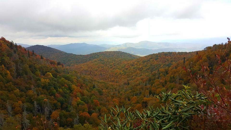
LOL at that white dot over Mt. Mitchell. Close to 4 feet I'd assume!
-
 1
1
-
-
-
26 minutes ago, HurricaneTracker said:
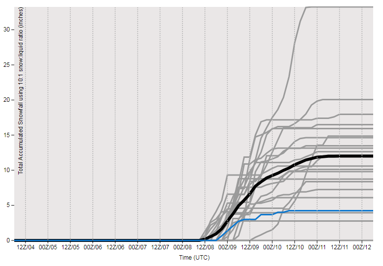
Just for fun, here is the snow plume diagram for KAVL from the 12/04 06Z GFS. The mean is 12.01" of snow...low of zero, max > 30" (HA!). But just another tool to consider.
http://www.emc.ncep.noaa.gov/gc_wmb/tdorian/gefs/EMCGEFSplumes.html
December 09 redux.
-
9 minutes ago, TARHEELPROGRAMMER88 said:
Cold air has trended weaker, storm more north, and people are starting to consider the NAM model outside of 48 hours. It is desperation time.
What are you watching?
-
17 minutes ago, Orangeburgwx said:
That poor county by the mountains in NC got completely whiffed in a snowhole
Cherokee County always gets screwed on these CAD events.
-
1
-
-
Just now, wncsnow said:
Still impressive for western sections. Keep in mind much of this would be sleet/slop
.thumb.png.6ecf4818c1afb0834cd14f518f64b8c9.png)
I expect the typical CAD areas along the escarpment, seeping into the French Broad River Valley and high elevations of the northern mountains, will do well.
-
Per the FV3, the Southern Escarpment is going to be the bullseye. Especially when you factor in some upslope potential. Could be historic.
-
3
-
-
Just now, WarmNose said:
Bad start at 12z with the ICON. Low track still looked good to me but it blew up and cold air was absent
HOWEVER, it was actually colder and further south than it's previous run. That would be a nice trend.
-
3
-
-
3 hours ago, franklin NCwx said:
Dont forget Franklin
If this setup stays consistent, southern upslope areas will take. From Franklin, Highlands to Hendersonville.
-
4 minutes ago, HurricaneTracker said:
I’ll just leave this here.
Check please!
-
It felt warmer this morning when I got up at 5a than it does now. Wind is picking up.
-
33 minutes ago, Buckethead said:
Robert was one of the best posters on here for years and developed a reputation that allows him to charge for his forecasting. I've seen him have far more great calls than busts over the years.
Exactly my thoughts. There are plenty of guys that someone could go after but Robert isn't of them.
-
1
-
-
1 minute ago, nchighcountrywx said:
Zirconia SC Mesowest DW1971
10:46am
NNW at 21 with Gusts to 54
Zirconia NC?
-
47 minutes ago, Upstate Tiger said:
It’s actually not unusual to have a Gulf landfalling hurricane impact upstate SC. 10 years ago when I worked for Greenville County we were working on our Hazard Vulnerabilty Assessment and we looked at the impacts of hurricanes on the upstate. Using historical data from the NWS we studied every named tropical system that had passed within 50 miles of downtown Greenville, SC. Amazingly almost all were from Gulf landfalling hurricanes. Very few were Atlantic landfalling hurricanes. That probably does not hold true for NC but for the upstate of SC, Gulf hurricanes have presented the greatest threat. Of course, to your point, I would bet few if any were still TS when they passed near Greenville.
Same rings true for WNC as well. I always think back to Ivan and Frances hitting days apart, and the sheer flooding it caused around here.
-
Not much changes on the 06z GFS however did notice the cool down starting earlier for the upper South with some cool air seeping in just east of mountains at hr180 for Virginia, NWNC and WNC.
-
1 hour ago, WarmNose said:
It snowed in October 3-4 years ago. This heat is NOT the new normal. Fwiw the rest of that winter was a major dud imby. Keep the heat pumping!
To be fair, that was Halloween night going into November 1st. I grew up in and have lived in these mountains my entire life. Even here it doesn't snow in October until late October if at all, and usually at high elevations.
To that point, I remember plenty of Halloween's with my children, trick or treating in shorts and short sleeves, and sweating, even here in the mountains. Heat in October is normal. Yes this heat is rather extreme due to its unwavering nature but heat now isn't abnormal. This weather pattern has some of you vexed and thinking irrationally.
It'll change folks. Probably sooner than later. Hang in there.
-
1
-
 2
2
-
-
47 minutes ago, Iceagewhereartthou said:
I'm gonna need some support. TWC latest says I don't get below 65 for the next 15 days and all next week I'm mid 80s.

This is turning into a fall nightmare. I mean, seriously dude, enough is enough.
You're putting stock in a 15 day forecast from the Weather Channel? Things are getting desperate around here.
-
1
-
-
2 hours ago, Hvward said:
Anyone have photos of wooly worms or persimmon seeds from this year? How about a count on how many morning of fog you had at your house in August, lol. I am writing a few articles on my website Ashevillewx.com detailing the various winter folklore that mountain people use. I would love to get a few quotes from you all regarding what your parents/grandparents used to say, and what you hear folks speaking of now. Thanks in advance for any help!
Morning fog in August was always a big one, as well as the mast crop and size of the shells on the acorns. Old timers used to believe that if the shell on the acorns extended lower on the nut itself then it would be a harsh winter.
My granddad personally believed that animals could tell us more about pending weather than anything else. He believed animals had a sixth sense developed specifically for the elements. How could they survive without it? If birds, squirrels and rodents were working harder than normal in the fall, winter was going to be cold. If their coats in October were thick and bushy, you can bet it was going to be cold. Ironically, I was hunting the other day and saw plenty of deer losing their summer coat despite how hot it has been. Rarely have I seen that in this weather. I wonder if grandaddy's folklore will ring true this year.
-
3
-
-
Models hinting at a decent cool down coming next week heading into October. First taste of fall? Let's hope.
-
1
-
-
34 minutes ago, BretWheatley said:
Real lull here currently near Hendersonville.
http://origin.wpc.ncep.noaa.gov/metwatch/metwatch_mpd_multi.php?md=0852&yr=2018

Are we expecting things to eventually pick back up again?
-
1 hour ago, Isopycnic said:
At least he wasn’t caught peeing on national tv this time.
That was at Sugar Mountain, wasn't it? Mike puts on a show everytime he comes to NC.
-
31 minutes ago, HurricaneTracker said:
Based on available guidance, including 00Z NAM, 18Z GFS, and 12Z Euro....the dividing line between some rain and a lot of rain will be I-26 or so.
3-6” for McDowell up to Avery.
Buncombe and Madison county storm total rain will be 1.0 to 1.5” and anything west of Asheville will be an inch or less. Henderson county will be 1-2”.
Models have not only sped up the departure of the remnants of Florence, but also trended north and east so the storm doesn’t go too far south into South Carolina. This pushes the best moisture and forcing well away from the southern Apps. So generally good news for WNC! In fact, I would cancel the Flood Watch for Buncombe, Madison, Haywood and points west.
Though my backyard is hard and dry as all get out, this will event will not help too much, especially for dry areas west of I-26.
others? Thoughts?
I did notice that although marginal, the NHC on their 11p update adjusted their cone slightly further west for WNC, than it was at 5p.
-
It's about to get nasty along the escarpment.
-
23 minutes ago, Eskimo Joe said:
I read somewhere that a person has died in Lenoir County as well, plugging in a generator. That would make 4.

.png.4880d9d15c507092c78180792781d77b.png)

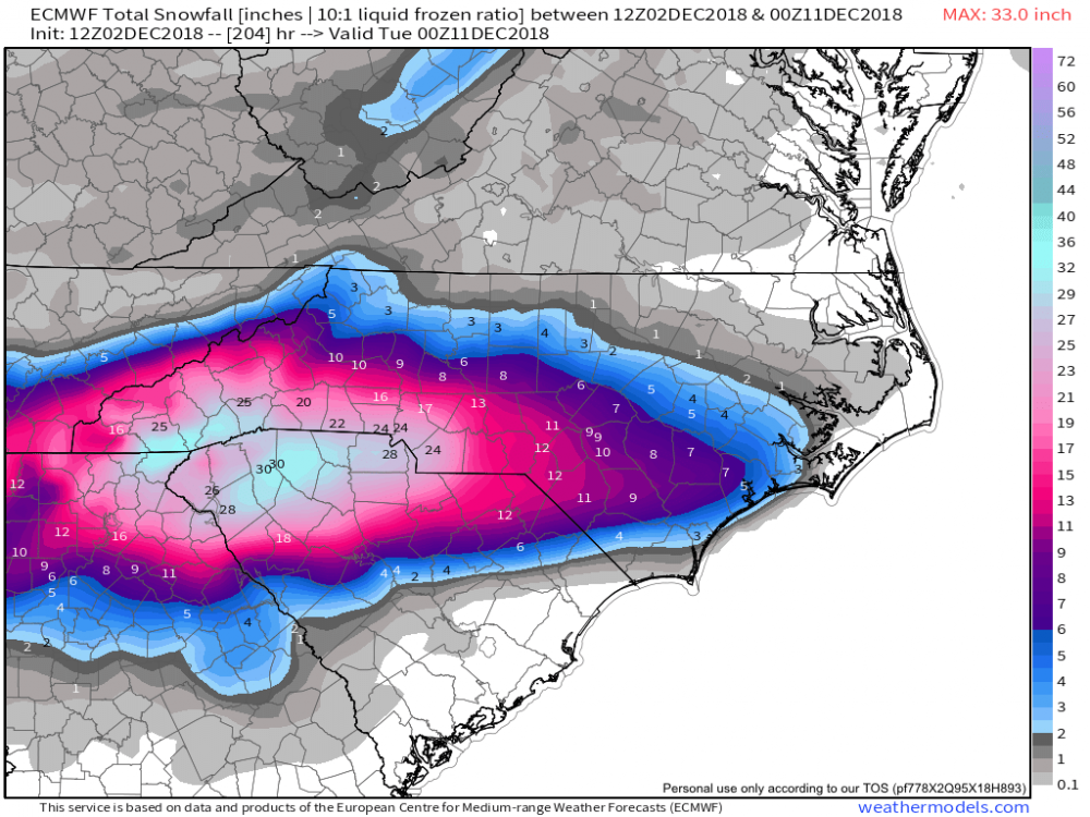
December 8-10, 2018 Winter Storm
in Southeastern States
Posted
Mt. Mitchell.